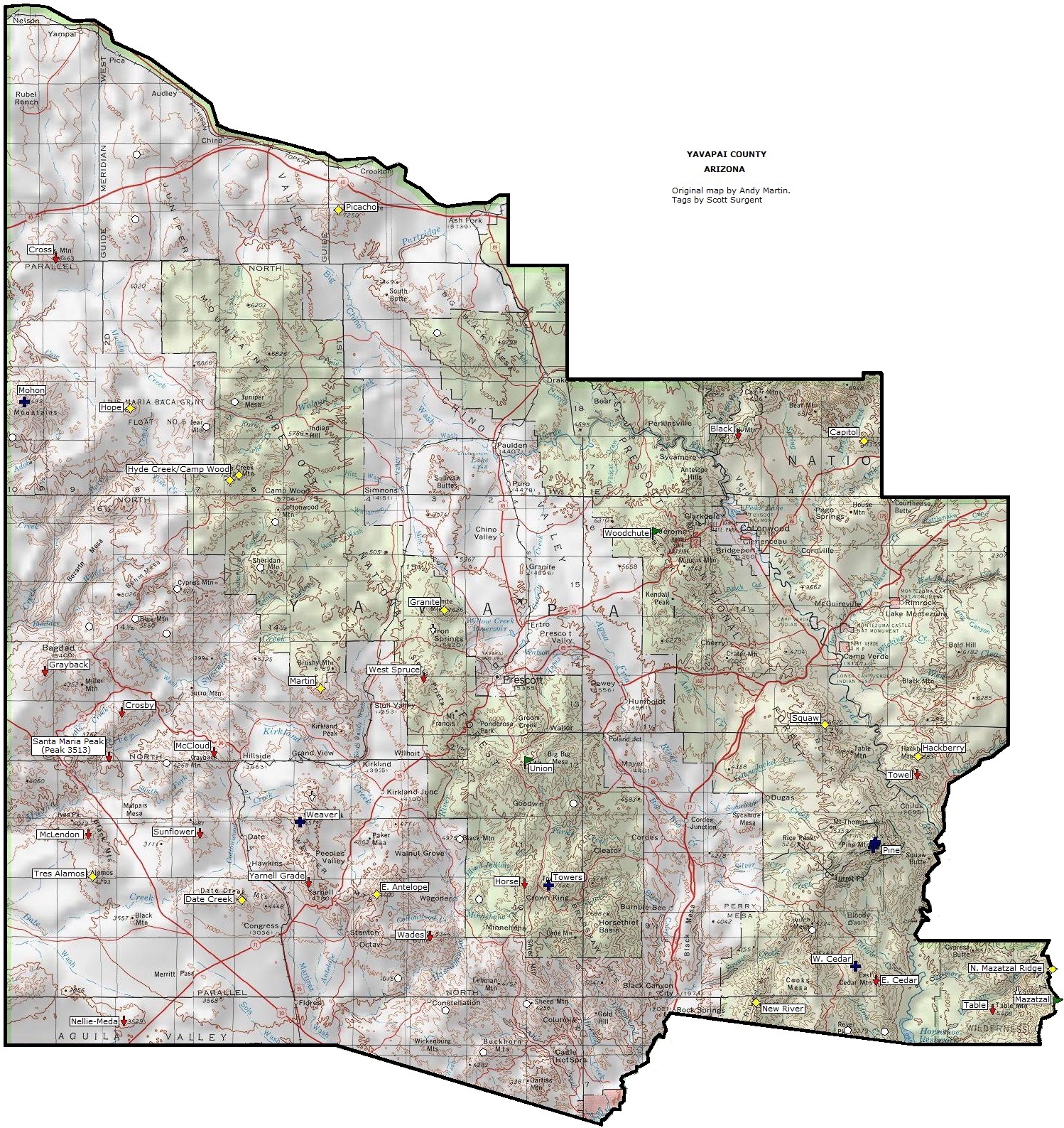
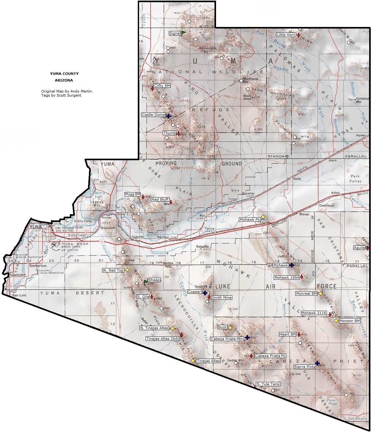
COUNTY MAPS
Click on the county map for an enlarged version, showing the peaks by location.
(Beware: the files are big, some above 1 MB)
These maps were derived from Andy Martin's maps at his website. The key to the markers are:

| Rank |
Name |
Elev. (ft) |
Prom. (ft) |
Range |
County |
Lat & Long |
Notes |
| 1 |
Mount Graham |
10,720 |
6,320 |
Pinaleno |
Graham |
32.7017, -109.8714 |
COHP • COPP • RHP • State Prom Leader • Ultra |
| 2 |
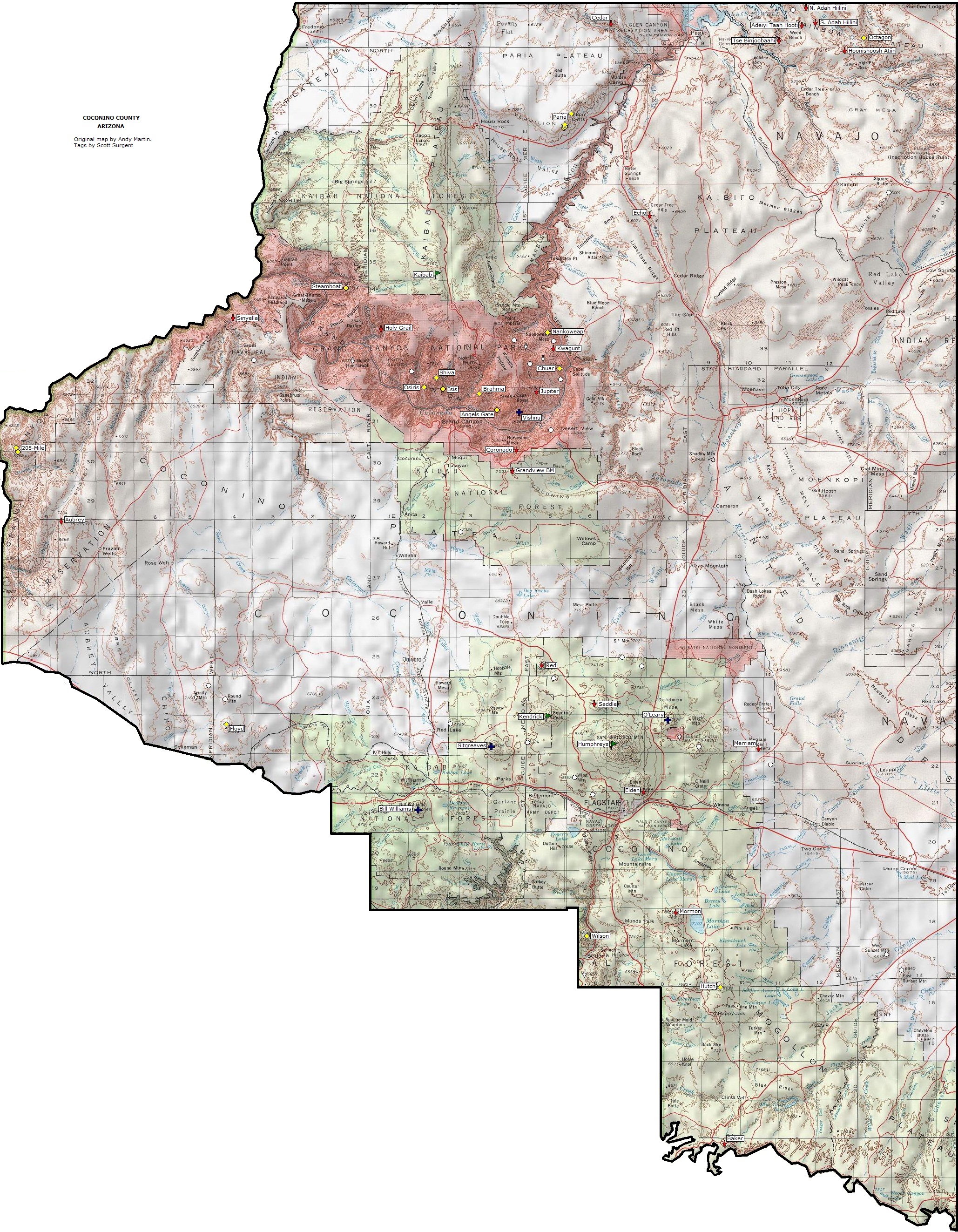
Humphreys Peak |
12,633 |
6,039 |
San Francisco |
Coconino |
35.3463, -111.6784 |
COHP • COPP • RHP • State Highpoint • Ultra |
| 3 |
Mount Lemmon |
9,157 |
5,157 |
Santa Catalina |
Pima |
32.4409, -110.7875 |
COHP • COPP • RHP • Ultra |
| 4 |
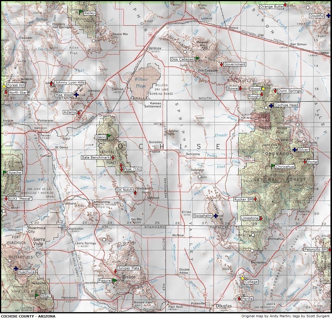
Chiricahua Peak |
9,759 |
5,139 |
Chiricahua |
Cochise |
31.8464, -109.2914 |
COHP • COPP • RHP • Ultra |
| 5 |
Miller Peak |
9,466 |
5,006 |
Huachuca |
Cochise |
31.3928, -110.2928 |
RHP • Ultra |
| 6 |
Mount Baldy |
11,403+ |
4,703+ |
White |
Apache |
33.9094, -109.5641 |
COHP • COPP • RHP • Fort Apache IRHP |
| 7 |
Mica Mountain |
8,666 |
4,610 |
Rincon |
Pima |
32.2209, -110.5431 |
RHP • Saguaro NPHP |
| 8 |
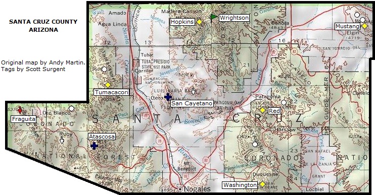
Mount Wrightson |
9,453 |
4,578 |
Santa Rita |
Santa Cruz |
31.6961, -110.8484 |
COHP • COPP • RHP |
| 9 |
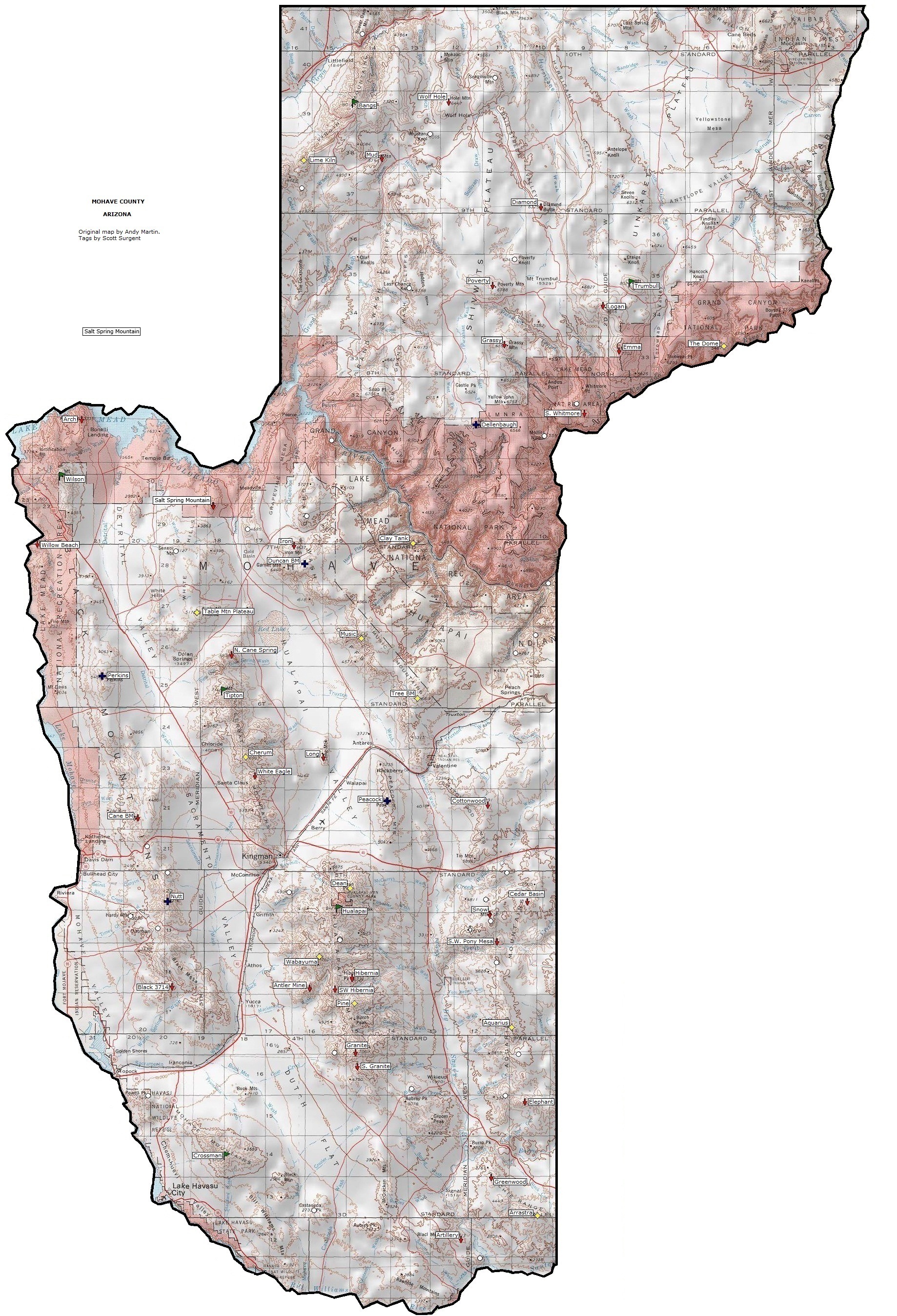
Hualapai Peak |
8,417 |
4,437 |
Hualapai |
Mohave |
35.0750, -113.9007 |
COHP • COPP • RHP |
| 10 |
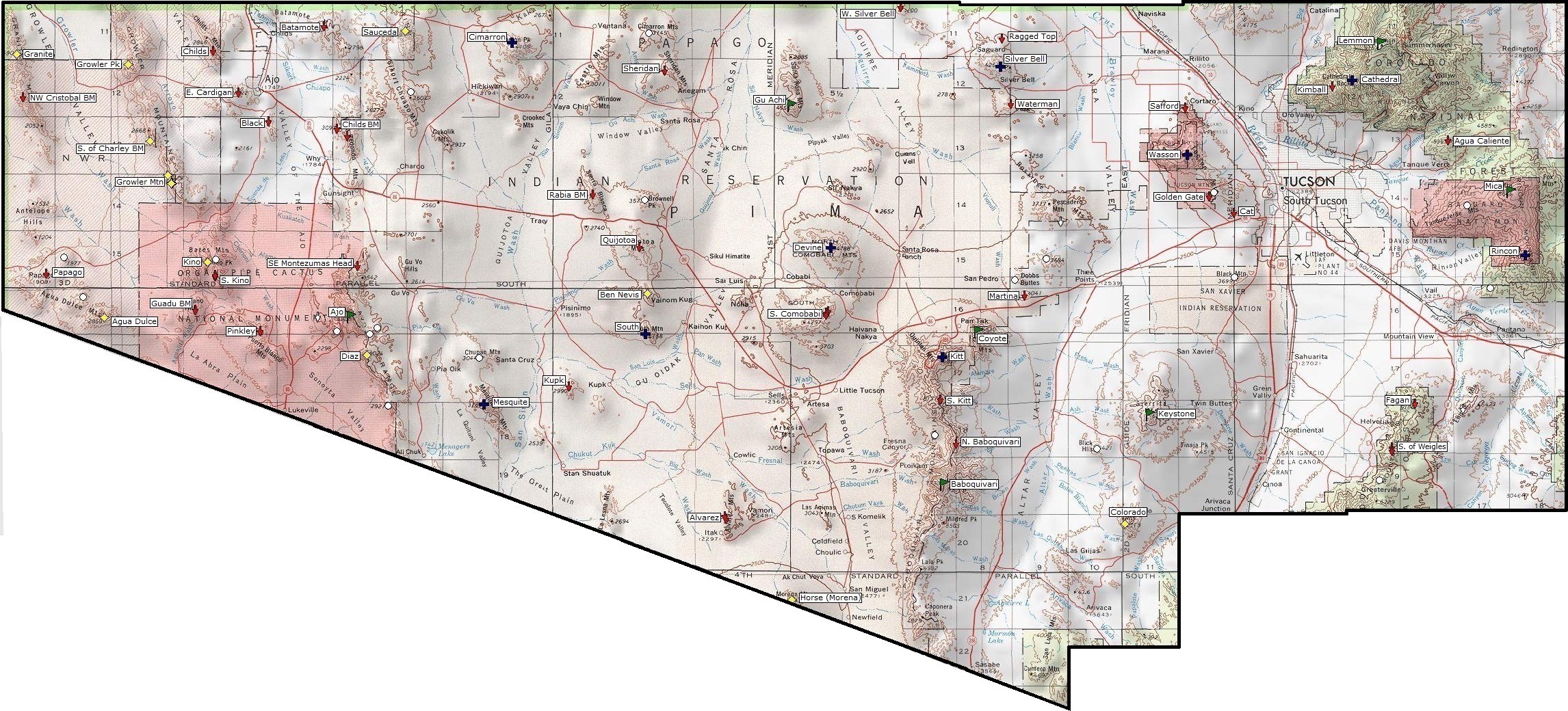
Baboquivari Peak |
7,734 |
4,194 |
Baboquivari |
Pima |
31.7711, -111.5956 |
RHP • Tohono O'odham IRHP |
| 11 |
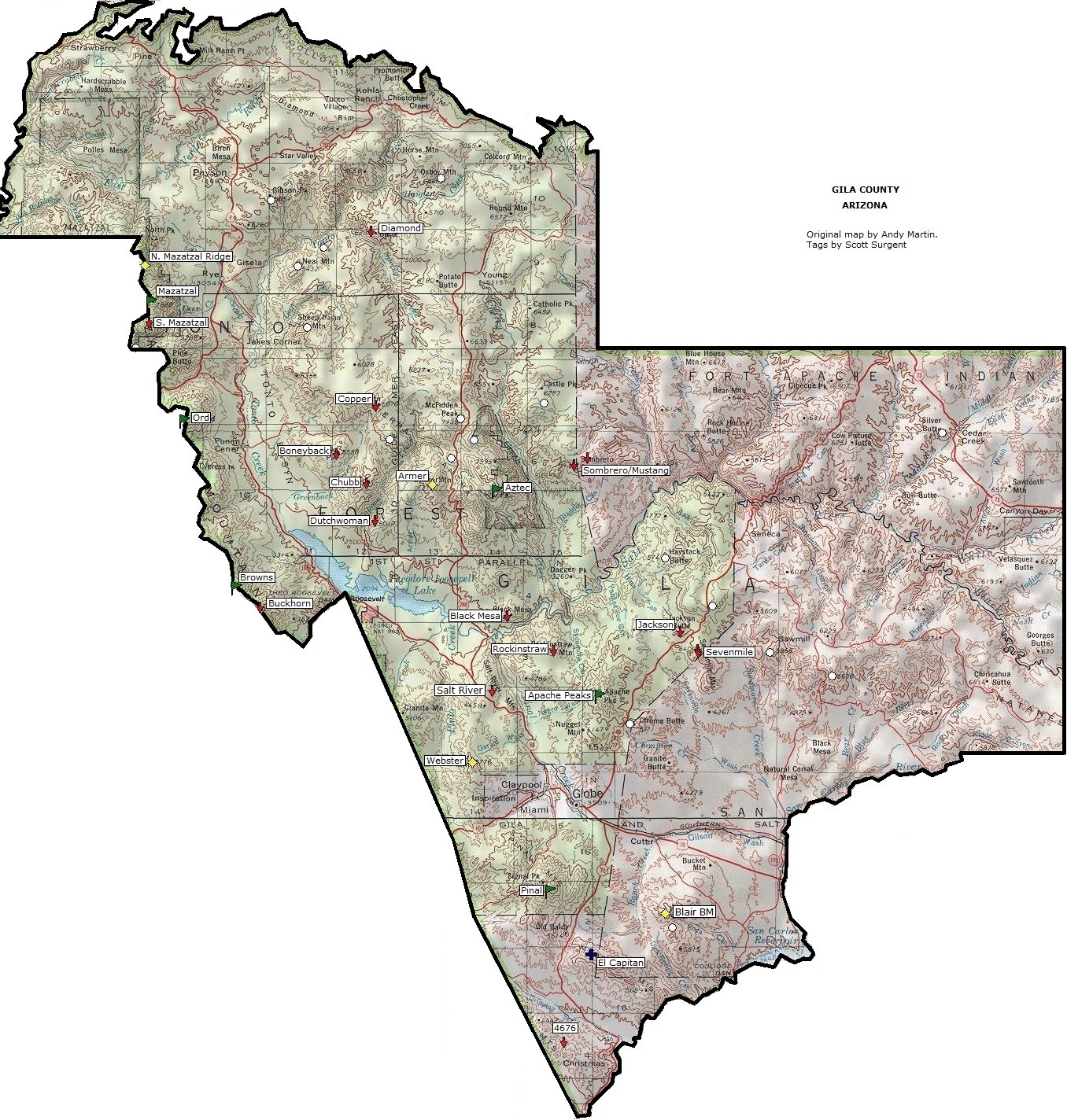
Pinal Peak |
7,848 |
4,090 |
Pinal |
Gila |
33.2822, -110.8212 |
COPP • RHP |
| 12 |
Mazatzal Peak |
7,903 |
3,943 |
Mazatzal |
Gila & Yavapai |
34.0625, -111.4615 |
COPP (Yavapai) • RHP |
| 13 |
Mount Tipton |
7,148 |
3,628 |
Cerbat |
Mohave |
35.5387, -114.1922 |
RHP |
| 14 |
Kaibab Plateau |
9,200 |
3,580 |
Kaibab |
Coconino |
36.3954, -112.1493 |
RHP • AZ Strip HP • near Grand Canyon NPHP |
| 15 |
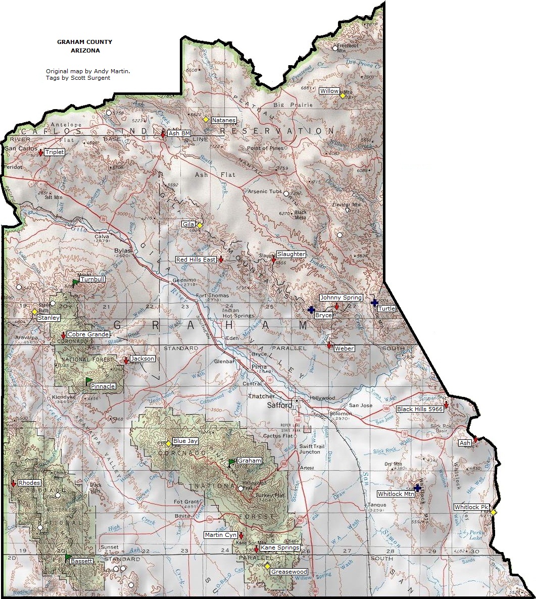
Mount Turnbull |
8,282 |
3,562 |
Santa Teresa |
Graham |
33.0739, -110.2609 |
RHP • San Carlos IRHP • BM "Turnbull Reset" |
| 16 |
Signal Peak |
4,877 |
3,477 |
Kofa |
Yuma |
33.3591, -114.0827 |
COHP • COPP • RHP • Kofa NWR • BM "Kofa 2" |
| 17 |
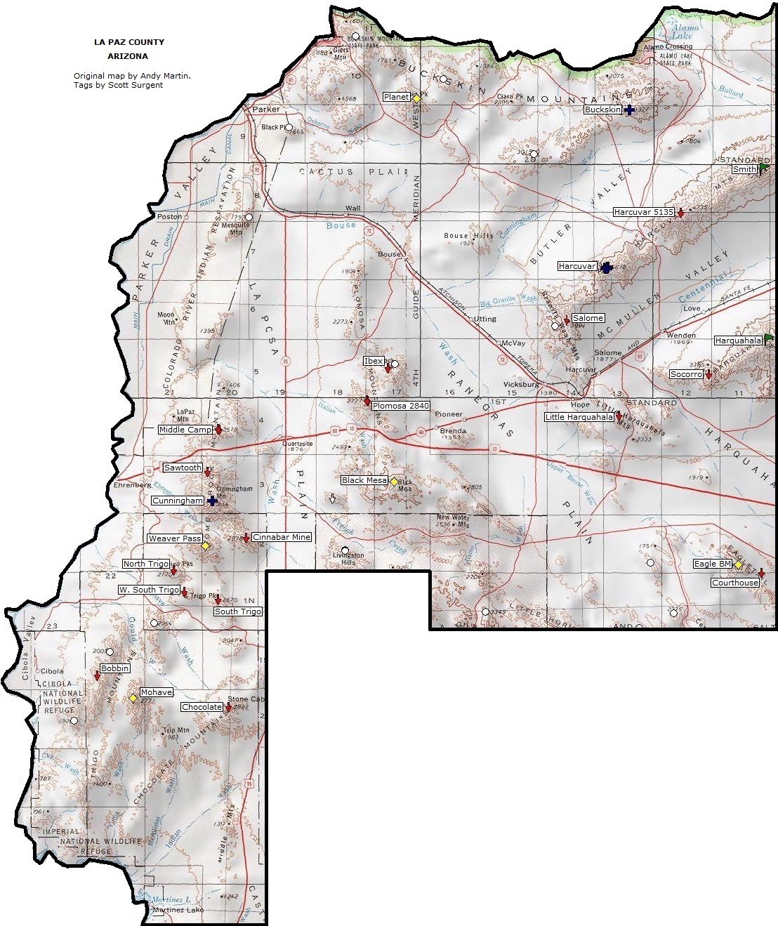
Harquahala Mountain |
5,681 |
3,461 |
Harquahala |
La Paz |
33.8111, -113.3468 |
COHP • COPP • RHP • BM "Harquahala" |
| 18 |
Browns Peak |
7,657 |
3,297 |
Mazatzal |
Gila & Maricopa |
33.6842, -111.3254 |
COHP • COPP (both Maricopa) • BM "Four Peaks Reset" |
| 19 |
Dos Cabezas Peak |
8,357 |
3,257 |
Dos Cabezas |
Cochise |
32.2212, -109.6099 |
RHP • South summit is ~6 ft higher than north |
| 20 |
Mount Wilson |
5,455 |
3,215 |
Black |
Mohave |
35.9966, -114.6119 |
RHP |
| 21 |
Hayes Peak |
4,512 |
3,212 |
Sierra Estrella |
Maricopa |
33.2728, -112.2801 |
RHP • Gila River IRHP • aka Sierra Estrella Peak |
| 22 |
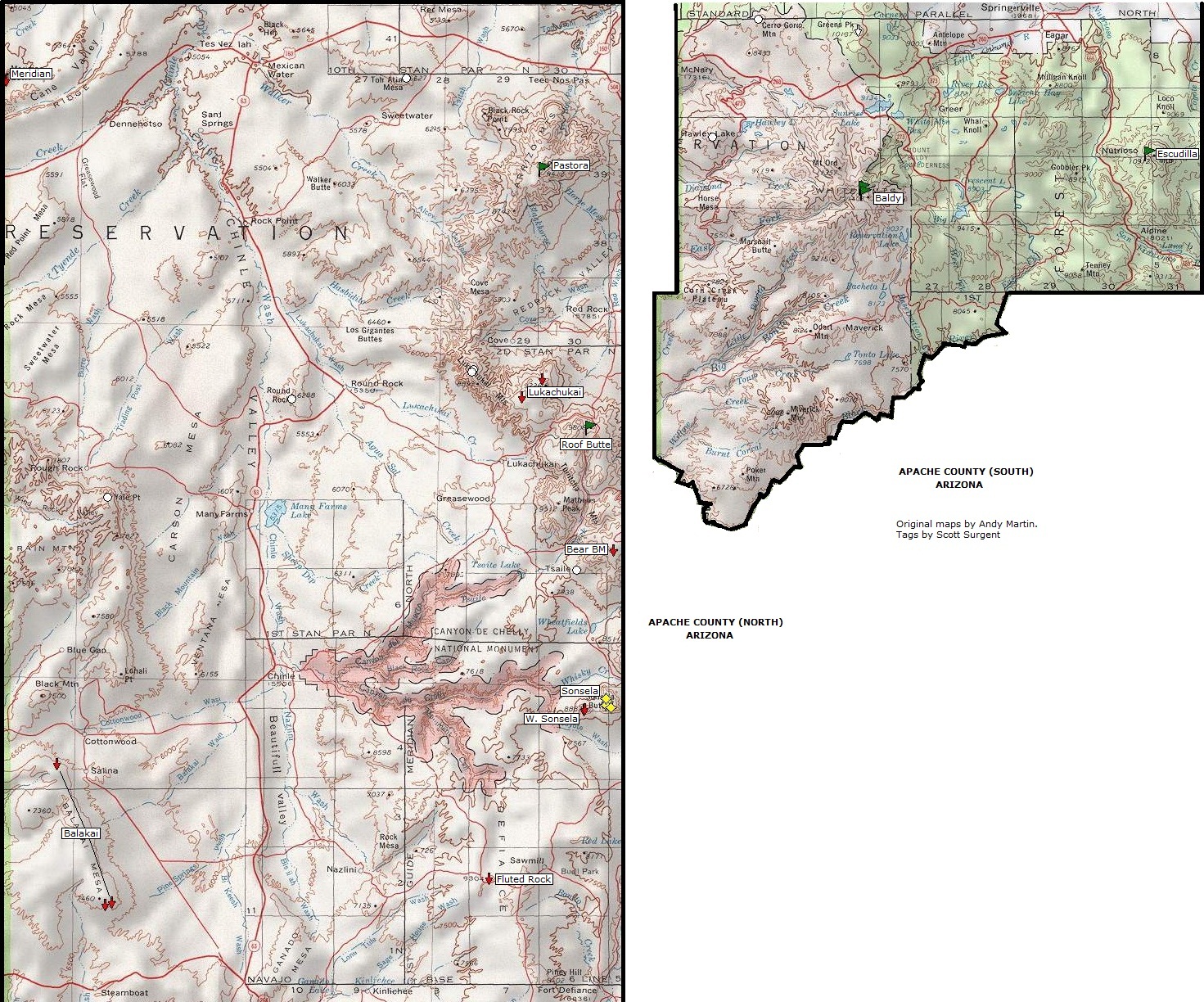
Roof Butte |
9,800 |
3,140 |
Chuska |
Apache |
36.4596, -109.0921 |
RHP • Navajo (Ariz.) IRHP |
| 23 |
Bassett Peak |
7,663 |
3,123 |
Galiuro |
Graham |
32.5061, -110.2798 |
RHP |
| 24 |
Crossman Peak |
5,100 |
3,120 |
Mojave |
Mohave |
34.5489, -114.1885 |
RHP |
| 25 |
Mount Trumbull |
8,029 |
2,969 |
Uinkaret |
Mohave |
36.4101, -113.1383 |
RHP • AZ Strip • Grand Canyon-Parashant NMHP |
| 26 |
Mount Union |
7,979 |
2,939 |
Bradshaw |
Yavapai |
34.4152, -112.4044 |
COHP • COPP • RHP |
| 27 |
Woodchute Mountain |
7,840 |
2,900 |
N. Black Hills |
Yavapai |
34.7497, -112.1757 |
RHP |
| 28 |
Mount Bangs |
8,012 |
2,892 |
Virgin |
Mohave |
36.7924, -113.8549 |
RHP (Virgin, AZ segment) |
| 29 |
Apache Peak |
7,711 |
2,886 |
Whetstone |
Cochise |
31.8250, -110.4269 |
RHP • BM "Stonewhet" |
| 30 |
Mount Glenn |
7,519 |
2,879 |
Dragoon |
Cochise |
31.9520, -109.9867 |
RHP • BM "Dragoon" |
| 31 |
Smith Peak |
5,242 |
2,792 |
Harcuvar |
La Paz |
34.0650, -113.3557 |
RHP |
| 32 |
Mount Ajo |
4,808 |
2,698 |
Ajo |
Pima |
32.0267, -112.6907 |
RHP • Organ Pipe Cactus NMHP • BM "Sierra del Ajo" |
| 33 |
Pastora Peak |
9,407 |
2,687 |
Carrizo |
Apache |
36.7902, -109.1645 |
RHP • NIR |
| 34 |
Fissure Peak |
7,370 |
2,670 |
Mule |
Cochise |
31.4470, -109.9639 |
RHP • N. of BM "Mule" on Mt. Ballard |
| 35 |
Gu Achi Peak |
4,556 |
2,636 |
Santa Rosa |
Pima |
32.3478, -111.8767 |
RHP • TOIR • BM "Santa Rosa 2" (removed) |
| 36 |
Apache Peaks |
6,940 |
2,580 |
Blackjack |
Gila |
33.5406, -110.7426 |
RHP |
| 37 |
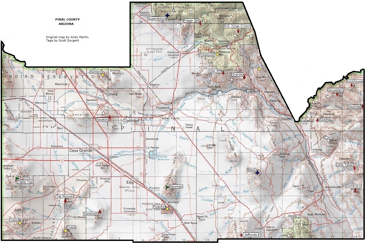
Newman Peak |
4,506 |
2,526 |
Picacho |
Pinal |
32.7189, -111.4003 |
COPP • RHP |
| 38 |
White Tank Mountain |
4,083 |
2,503 |
White Tank |
Maricopa |
33.5752, -112.5788 |
RHP (aka Goldwater Peak) |
| 39 |
Kendrick Peak |
10,418 |
2,478 |
S. F. Volcanic Field |
Coconino |
35.4080, -111.8507 |
LO • Kendrick Mountain Wilderness |
| 40 |
Pinnacle Ridge |
7,550 |
2,470 |
Santa Theresa |
Graham |
32.8712, -110.2274 |
|
| 41 |
Aztec Peak |
7,748 |
2,468 |
Sierra Ancha |
Gila |
33.8111, -110.9058 |
RHP, LO |
| 42 |
Keystone Peak |
6,188 |
2,448 |
Sierrita |
Pima |
31.8774, -111.2155 |
RHP • LO |
| 43 |
Mount Ord |
7,128 |
2,408 |
Mazatzal |
Gila & Maricopa |
33.9047, -111.4087 |
LO |
| 44 |
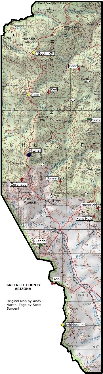
Guthrie Peak |
6,751 |
2,391 |
Peloncillo/Black |
Graham & Greenlee |
32.8870, -109.3150 |
COPP (Greenlee) • RHP • BM "Guthrie" |
| 45 |
Maple Peak |
8,294 |
2,370 |
Sierra Aguilada |
Greenlee |
33.3470, -109.1020 |
RHP • Possible COPP (Greenlee) |
| 46 |
Escudilla Mountain |
10,912 |
2,360 |
White |
Apache |
33.9550, -109.1258 |
LO at south summit (10,877 ft) |
| 47 |
Table Top |
4,363 |
2,333 |
Table Top |
Pinal |
32.7524, -112.1253 |
RHP • Trail to S. summit |
| 48 |
Coyote Mountain |
6,529 |
2,329 |
Coyote |
Pima |
32.0038, -111.5327 |
RHP • Coyote Mtns Wilderness |
| 49 |
Sheep Mountain |
3,156 |
2,326 |
Gila |
Yuma |
32.5328, -114.2339 |
RHP • BMGAFR |
| 50 |
Reiley Peak |
7,640 |
2,320 |
Winchester |
Cochise |
32.3886, -110.1078 |
RHP • South tip higher than north |
| 51 |
Bill Williams Mountain |
9,256 |
2,306 |
Bill Williams |
Coconino |
35.1994, -112.2048 |
RHP • LO |
| 52 |
Rincon Peak |
8,482 |
2,302 |
Rincon |
Pima |
32.1206, -110.5231 |
Saguaro NP |
| 53 |
Bryce Mountain |
7,298 |
2,228 |
Gila |
Graham |
33.0200, -109.6723 |
RHP • SCIR |
| 54 |
Duncan Benchmark |
6,769 |
2,209 |
Music |
Mohave |
35.8093, -113.9836 |
RHP • BM "Duncan" • Grand Wash Cliffs Complex |
| 55 |
Doubtful Peak |
6,520 |
2,193 |
Peloncillo |
Cochise |
32.3726, -109.0512 |
Name became official May 2023 |
| 56 |
Mohawk Mountain |
2,775 |
2,140 |
Mohawk |
Yuma |
32.5895, -113.6471 |
RHP • BMGAFR |
| 57 |
Cunningham Mountain |
3,316 |
2,136 |
Dome Rock |
La Paz |
33.5700, -114.3496 |
RHP |
| 58 |
Weaver Peak |
6,574 |
2,134 |
Weaver |
Yavapai |
34.3272, -112.8099 |
RHP |
| 59 |
Wasson Peak |
4,687 |
2,117 |
Tucson |
Pima |
32.2724, -111.1445 |
RHP • Saguaro NPHP (West Unit) |
| 60 |
Kitt Peak |
6,880 |
2,092 |
Quinlan |
Pima |
31.9639, -111.5998 |
RHP • TOIR • BM "Kitts" • multiple observatories |
| 60 |
Peacock Peak |
6,292 |
2,092 |
Peacock |
Mohave |
35.3044, -113.7727 |
RHP |
| 62 |
Castle Dome Peak |
3,877 |
2,088 |
Castle Dome |
Yuma |
33.0844, -114.1432 |
RHP • Kofa NWR • BM "Castle Dome" |
| 63 |
Woolsey Peak |
3,171 |
2,081 |
Gila Bend |
Maricopa |
33.1672, -112.8854 |
RHP • BM "Gila Peak" |
| 64 |
Mohon Peak |
7,499 |
2,059 |
Mohon |
Mohave |
34.9489, -113.2990 |
RHP • BM "Mohon Water" |
| 65 |
Pine Mountain |
6,814 |
2,054 |
Verde Rim |
Yavapai |
34.2976, -111.7872 |
RHP • BM "Wild" • four areas |
| 66 |
Harcuvar Peak |
4,618 |
2,048 |
Harcuvar |
La Paz |
33.9161, -113.6396 |
BM "Harcuvar" • Areas to NE slightly higher |
| 67 |
Mount Perkins |
5,456 |
2,036 |
Black |
Mohave |
35.5699, -114.5085 |
BM "Perkins" |
| 68 |
Mae West Peak |
6,726 |
2,026 |
Little Dragoon |
Cochise |
32.0973, -110.1257 |
RHP • BM "Lime" (absent) |
| 69 |
Swisshelm Mountain |
7,185 |
2,025 |
Swisshelm |
Cochise |
31.6745, -109.5353 |
RHP • BM "Swiss" |
| 70 |
South Mountain |
4,160 |
2,020 |
South |
Pima |
31.9995, -112.1491 |
RHP • TOIR |
| 71 |
Pinta Benchmark |
2,950 |
2,010 |
Sierra Pinta |
Yuma |
32.2631, -113.5429 |
RHP • CPNWR • BM "Pinta" on map, actually "Pinto" |
| 72 |
Silver Peak |
8,008 |
2,008 |
Chiricahua |
Cochise |
31.9045, -109.1972 |
BM "Silver Peak" • Former LO site |
| 73 |
Turtle Mountain |
7,004 |
2,004 |
Turtle |
Graham |
33.0342, -109.5147 |
RHP • SCIR • BM "Highest Peak" |
| 74 |
Cimarron Peak |
4,124 |
1,984 |
Cimarron |
Pima |
32.4375, -112.3948 |
RHP • TOIR • BM "Cimarron" on lower summit to SW |
| 75 |
Mount Devine |
4,783 |
1,983 |
N. Comobabi |
Pima |
32.1321, -111.8047 |
RHP • TOIR |
| 76 |
Copper Mountain |
2,888 |
1,968 |
Copper |
Yuma |
32.4995, -113.9973 |
RHP • BMGAFR |
| 77 |
Atascosa Peak |
6,422 |
1,960 |
Atascosa |
Santa Cruz |
31.4325, -111.1475 |
RHP • BM "Pajarita" • LO on lower S. summit |
| 78 |
Sitgreaves Mountain |
9,389 |
1,949 |
S. F. Volcanic Field |
Coconino |
35.3422, -112.0062 |
BM "Sitgreaves" |
| 79 |
Towers Mountain |
7,628 |
1,948 |
Bradshaw |
Yavapai |
34.2341, -112.3679 |
LO • Crown King area |
| 80 |
San Cayetano Peak |
6,004 |
1,924 |
San Cayetano |
Santa Cruz |
31.5334, -110.9620 |
RHP |
| 81 |
Silver Bell Peak |
4,261 |
1,921 |
Silver Bell |
Pima |
32.4181, -111.5053 |
RHP • Ironwood Forest Nat. Mon. HP |
| 82 |
Cathedral Rock |
7,957 |
1,917 |
Santa Catalina |
Pima |
32.3856, -110.8433 |
Multiple pillars, low 5th class |
| 83 |
Cochise Head |
8,113 |
1,913 |
Chiricahua |
Cochise |
32.0592, -109.2997 |
|
| 84 |
Huachuca Peak |
8,410 |
1,910 |
Huachuca |
Cochise |
31.4903, -110.3823 |
Fort Huachuca MR |
| 85 |
Black Mountain |
5,587 |
1,907 |
Black |
Pinal |
32.7772, -110.9619 |
RHP |
| 86 |
Buckskin Mountain |
3,927 |
1,887 |
Buckskin |
La Paz |
34.1515, -113.5977 |
RHP |
| 87 |
Eagletail Peak |
3,300 |
1,880 |
Eagletail |
Maricopa |
33.4029, -113.3047 |
RHP |
| 88 |
Mitchell Peak |
7,951 |
1,831 |
White |
Greenlee |
33.2187, -109.3670 |
Near Sardine Saddle |
| 89 |
Cabeza Prieta Mountain |
2,930 |
1,830 |
Cabeza Prieta |
Yuma |
32.3497, -113.8240 |
RHP • CPNWR • BM "Cabeza" |
| 90 |
Superstition Peak |
5,057 |
1,817 |
Superstition |
Pinal |
33.4111, -111.4006 |
RHP • BM "Superstition" |
| 91 |
Vishnu Temple |
7,533 |
1,813 |
Grand Canyon |
Coconino |
36.0891, -111.9359 |
GCNP |
| 92 |
El Capitan Mountain |
6,568 |
1,808 |
El Capitan |
Gila |
33.2000, -110.7562 |
RHP • BM "Pioneer" |
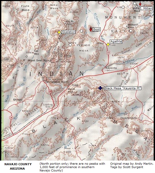
| 93 |
"Kayenta Point" |
8,168 |
1,808 |
Black Mesa |
Navajo |
36.6529, -110.2638 |
COHP • COPP • RHP • NIR • Near BM "Kayenta" |
| 94 |
Whitlock Mountain |
5,682 |
1,782 |
Whitlock |
Graham |
32.6501, -109.4070 |
RHP |
| 95 |
O'Leary Peak |
8,938 |
1,778 |
S. F. Volcanic Field |
Coconino |
35.4025, -111.5319 |
LO • near Bonito Lava Flow |
| 96 |
Saddle Mountain |
3,037 |
1,777 |
|
Maricopa |
33.4402, -113.0380 |
RHP • BM "Saddle Mtn" |
| 97 |
Nutt Benchmark |
5,216 |
1,776 |
Black |
Mohave |
35.0905, -114.3396 |
Located 0.75 mile east of Mt Nutt, BM "Nutt" |
| 98 |
West Cedar Mountain |
5,489 |
1,769 |
Cedar |
Yavapai |
34.1140, -111.8197 |
RHP • Near East Cedar (#240) |
| 98 |
Mesquite Mountain |
3,789 |
1,769 |
Mesquite |
Pima |
31.8928, -112.4454 |
RHP • TOIR |
| 100 |
Mount Dellenbaugh |
7,072 |
1,752 |
Shivwits Plateau |
Mohave |
36.1085, -113.5413 |
AZ Strip • Lake Mead Nat. Rec. Area |
| Rank |
Name |
Elev. (ft) |
Prom. (ft) |
Range |
County |
Lat & Long |
Notes |
| 101 |
College Peaks |
6,768 |
1,748 |
Perilla |
Cochise |
31.4549, -109.4217 |
RHP |
| 102 |
Greasewood Mountain |
7,094 |
1,734 |
S. Pinaleno |
Graham |
32.4914, -109.7806 |
BM "Grease" |
| 103 |
Tinajas Altas Peak |
2,764 |
1,724 |
Tinajas Altas |
Yuma |
32.2725, -114.0466 |
RHP • BMGAFR |
| 104 |
Clay Tank Canyon (North) |
4,630 |
1,710 |
Grand Canyon |
Mohave |
35.8536, -113.7031 |
HuIR • GCNP |
| 105 |
Mount Washington |
7,221 |
1,709 |
Patagonia |
Santa Cruz |
31.3530, -110.7240 |
RHP |
| 106 |
Mound Mountain |
6,266 |
1,706 |
Superstition (?) |
Maricopa |
33.4712, -111.1363 |
Sometimes considered part of Superstition range |
| 107 |
Whitlock Peak |
6,211 |
1,691 |
Whitlock |
Graham & Greenlee |
32.6014, -109.2178 |
|
| 108 |
Harquahala 4489 |
4,489 |
1,689 |
Harquahala |
Maricopa |
33.8674, -113.2256 |
Northeast tip of range |
| 109 |
Blue Jay Peak
|
8,840 |
1,680 |
Pinaleno |
Graham |
32.7423, -110.0296 |
N. of West Peak LO |
| 110 |
Ben Nevis Mountain |
4,011 |
1,671 |
Quijotoa |
Pima |
32.0616, -112.1444 |
RHP • TOIR • BM "Nevis" |
| 111 |
Bronco Butte |
4,349 |
1,669 |
Salt River Canyon |
Maricopa |
33.5536, -111.2761 |
N. of Fish Creek Grade (AZ-88) |
| 111 |
Stanley Butte |
7,029 |
1,669 |
|
Graham |
33.0149, -110.3646 |
SCIR |
| 113 |
Granite Mountain |
7,626 |
1,666 |
Sierra Prieta |
Yavapai |
34.6378, -112.5533 |
RHP • BM on top (unstamped) |
| 114 |
Mount Floyd |
7,441 |
1,661 |
Coconino Plateau |
Coconino |
35.3927, -112.7240 |
RHP |
| 115 |
Monreal Benchmark |
2,400 |
1,660 |
Mohawk |
Yuma |
32.4954, -113.5318 |
BM "Monreal" • BMGAFR |
| 116 |
Black Mesa |
3,639 |
1,659 |
Plomosa |
La Paz |
33.5999, -114.0188 |
RHP • New Water Mountains Wilderness |
| 117 |
Hyde Creek Mountain |
7,272 |
1,650 |
Santa Maria |
Yavapai |
34.8352, -112.9187 |
Nearby Camp Wood Peak nearly as high |
| 118 |
Isis Temple |
7,006 |
1,646 |
Grand Canyon |
Coconino |
36.1408, -112.1379 |
GCNP |
| 119 |
Nankoweap Mesa |
6,316 |
1,636 |
Grand Canyon |
Coconino |
36.2672, -111.8576 |
GCNP |
| 120 |
Rose Peak |
8,786 |
1,626 |
White |
Greenlee |
33.4392, -109.3715 |
LO • BM "Rose" on lower summit |
| 121 |
Granite Mountain |
2,490 |
1,620 |
Granite |
Pima |
32.4261, -113.3059 |
RHP • BMGAFR • BM "Granite" |
| 122 |
Gro Benchmark |
3,293 |
1,613 |
Growler |
Pima |
32.2441, -113.0263 |
RHP • CPNWR • BMGAFR • BM "Gro", +4 areas 1 mi. S |
| 123 |
Hutch Mountain |
8,535 |
1,612 |
S. F. Volcanic Field |
Coconino |
34.8019, -111.3901 |
LO • Mormon Plateau HP |
| 123 |
Prieta Peak |
3,332 |
1,612 |
Slate |
Pinal |
32.5460, -111.8882 |
RHP • TOIR • BM "Sierra Prieta" (unstamped) |
| 125 |
Blair Benchmark |
5,757 |
1,597 |
Hog |
Gila |
33.2536, -110.6357 |
RHP • SCIR • BM "Blair" + 1 unstamped |
| 126 |
Sauceda Mountain |
4,118 |
1,595 |
Sauceda |
Pima |
32.4606, -112.5886 |
RHP • Near TOIR boundary, NE of Ajo • BM "Sauceda" |
| 127 |
Agua Dulce Mountain |
2,850 |
1,590 |
Agua Dulce |
Pima |
32.0256, -113.1451 |
RHP • CPNWR • BM "Quitovaguita" |
| 128 |
San Tan Mountain |
3,104 |
1,589 |
Santan |
Pinal |
33.1733, -111.7090 |
RHP • Gila River Indian Reservation |
| 129 |
Cherum Peak |
6,983 |
1,583 |
Cerbat |
Mohave |
35.3977, -114.1385 |
BM "Mineral" |
| 130 |
Monson Benchmark |
2,411 |
1,581 |
Mohawk |
Yuma |
32.4059, -113.4682 |
RHP • BMGAFR • BM "Monson" |
| 131 |
Octagon Butte |
6,700 |
1,580 |
Rainbow Plateau |
Coconino |
36.9249, -111.0004 |
BM "Cummings" |
| 132 |
Picacho Peak |
3,370 |
1,570 |
Picacho |
Pinal |
32.6350, -111.4006 |
Arizona's only "Via Ferrata" |
| 133 |
N. Tinajas Altas Mtn |
2,720 |
1,560 |
N. Tinajas |
Yuma |
32.3819, -114.1273 |
RHP • BMGAFR |
| 133 |
Date Creek Mountain |
4,920 |
1,560 |
Date Creek |
Yavapai |
34.2142, -112.9144 |
RHP |
| 135 |
Cerro Colorado Mountain |
5,319 |
1,559 |
Cerro Colorado |
Pima |
31.7110, -111.2626 |
RHP • BM "Colorado" • Near Arivaca Rd. |
| 136 |
Martin Mountain |
6,436 |
1,556 |
Martin |
Yavapai |
34.5233, -112.7729 |
W. of Skull Valley |
| 137 |
Table Mountain Plateau |
5,175 |
1,555 |
White Hills |
Mohave |
35.7042, -114.2628 |
BM "Yucca Spring" |
| 138 |
Forest Hill |
6,114 |
1,554 |
Little Rincon |
Cochise |
32.1275, -110.4317 |
RHP |
| 139 |
Vekol Mountain |
3,609 |
1,549 |
Vekol |
Pinal |
32.5778, -112.1117 |
RHP |
| 140 |
Lime Kiln Mountain |
6,464 |
1,544 |
Virgin |
Mohave |
36.6717, -113.9862 |
AZ Strip • BM "Tungsten" |
| 140 |
Mustang Mountains HP |
6,469 |
1,544 |
Mustang |
Santa Cruz |
31.6794, -110.4681 |
RHP • E. of Sonoita |
| 142 |
Planet Peak |
3,141 |
1,541 |
Buckhorn |
La Paz |
34.1669, -113.9816 |
BM "Planet" |
| 143 |
Kino Peak |
3,197 |
1,537 |
Bates |
Pima |
32.1093, -112.9538 |
RHP • Organ Pipe Cactus NM • BM "Tesmo" (?) |
| 144 |
"E of 205-Mile Rapid" |
6,573 |
1,533 |
Grand Canyon |
Coconino |
36.0002, -113.2904 |
HuIR • GCNP • Area 3/4 mi north also as high |
| 145 |
"N. Mazatzal Ridge" |
7,571 |
1,531 |
Mazatzal |
Gila |
34.1107, -111.4733 |
N. of Sandy Saddle Trail at Sandy Saddle |
| 146 |
Growler Peak |
3,027 |
1,527 |
Growler |
Pima |
32.4097, -113.1010 |
CPNWR • BM "Growler" |
| 147 |
Wabayuma Peak |
7,601 |
1,521 |
Hualapai |
Mohave |
34.9725, -113.9471 |
Main summit, south half of range |
| 148 |
"East Antelope Peak" |
6,400 |
1,520 |
S. Weaver |
Yavapai |
34.2203, -112.6741 |
RHP • BM "East Antelope" |
| 149 |
Webster Mountain |
5,781 |
1,519 |
|
Gila |
33.4533, -110.9462 |
Point S. of BM is higher ~10+ feet |
| 150 |
Mount Suappoa |
2,700 |
1,510 |
South |
Maricopa |
33.3309, -112.0654 |
In city of Phoenix, TV Towers • BM "Telegraph" |
| 151 |
Mount Hope |
7,263 |
1,503 |
|
Yavapai |
34.9394, -113.1104 |
Baca Land Grant Float HP, no access |
| 152 |
Aquarius Mountain |
6,236 |
1,496 |
Aquarius |
Mohave |
34.8226, -113.4479 |
RHP • North of BM "Bonner" |
| 153 |
Dean Peak |
8,013 |
1,493 |
Hualapai |
Mohave |
35.1167, -113.8685 |
Immediately NE of Hualapai Peak |
| 153 |
Chuar Butte |
6,480 |
1,493 |
Grand Canyon |
Coconino |
36.1938, -111.8254 |
GCNP |
| 155 |
Natanes Mountain |
7,520 |
1,490 |
Natanes |
Graham |
33.4129, -109.9371 |
RHP • SCIR |
| 156 |
Mohave Peak |
2,768 |
1,488 |
Trigo |
La Paz |
33.2767, -114.4916 |
Yuma Proving Grounds MR |
| 157 |
Arrastra Mountain |
4,807 |
1,487 |
Poachie |
Mohave |
34.4211, -113.3790 |
RHP • BM "Poachie" |
| 158 |
Javelina Mountain |
4,084 |
1,484 |
Javelina/Sand Tank |
Maricopa |
32.7513, -112.3779 |
aka Maricopa Peak • RHP • BM "Maricopa 2" |
| 158 |
Diaz Peak |
4,024 |
1,484 |
Diaz |
Pima |
31.9678, -112.6626 |
RHP • Organ Pipe Cactus NM |
| 160 |
Sonsela Buttes |
8,960 |
1,480 |
Sonsela |
Apache |
36.1079, -109.0680 |
RHP • NIR |
| 161 |
Tres Alamos |
4,293 |
1,473 |
Black |
Yavapai |
34.2466, -113.1796 |
BM "Sawyer" |
| 162 |
Osiris Temple |
6,613 |
1,469 |
Grand Canyon |
Coconino |
36.1449, -112.1876 |
GCNP • SW of Shiva Temple |
| 163 |
Picacho Butte |
7,168 |
1,468 |
Coconino Plateau |
Yavapai |
35.2300, -112.7410 |
|
| 163 |
Brahma Temple |
7,551 |
1,468 |
Grand Canyon |
Coconino |
36.1302, -112.0387 |
GCNP |
| 165 |
Pine Peak |
7,225 |
1,465 |
Hualapai |
Mohave |
34.8741, -113.8568 |
BM "Judi" |
| 166 |
Picketpost Mountain |
4,375 |
1,455 |
|
Pinal |
33.2576, -111.1576 |
W. of Superior, S. of US-60; AZ Trail nearby |
| 167 |
Wood Mountain |
7,326 |
1,446 |
Chiricahua |
Cochise |
32.1211, -109.3339 |
|
| 168 |
Mount Hopkins |
8,560 |
1,440 |
Santa Rita |
Santa Cruz |
31.6884, -110.8853 |
Whipple Observatory |
| 169 |
Agathla Peak |
7,096 |
1,436 |
Monument Valley |
Navajo |
36.8266, -110.2256 |
Spire, NIR • aka El Capitan |
| 170 |
Capitol Butte |
6,355 |
1,435 |
Red Rocks of Sedona |
Yavapai |
34.8858, -111.8066 |
|
| 171 |
Maricopa Mountain |
3,272 |
1,432 |
Maricopa |
Maricopa |
32.9475, -112.3930 |
RHP • S. of AZ-238 |
| 172 |
Nose Benchmark |
2,349 |
1,429 |
Gila Bend |
Maricopa |
33.0851, -112.7304 |
BM "Nose" |
| 172 |
Gila Peak |
6,629 |
1,429 |
Gila |
Graham |
33.1931, -109.9520 |
Fishhooks Wilderness • SCIR • BM "Gila" |
| 174 |
"Weaver Pass Summit" |
2,747 |
1,427 |
Dome Rock |
La Paz |
33.5040, -114.3613 |
2 mi. W of Weaver Pass |
| 175 |
Mohawk Peak |
1,975 |
1,425 |
Mohawk |
Yuma |
32.7493, -113.7623 |
Spire, north side of I-8 |
| 176 |
Music Mountain |
6,697 |
1,417 |
Music |
Mohave |
35.6494, -113.8377 |
Grand Wash Cliffs complex |
| 177 |
Tumacacori Mountain |
5,736 |
1,416 |
Tumacacori |
Santa Cruz |
31.5581, -111.1114 |
RHP • on ridge N of BM "Tumac" |
| 178 |
Wilson Mountain |
7,122 |
1,402 |
Coconino Plateau |
Yavapai |
34.9180, -111.7524 |
Secret Mountain Wilderness |
| 179 |
Big Horn Peak |
3,480 |
1,400 |
Big Horn |
Maricopa |
33.6083, -113.1507 |
RHP |
| 180 |
Red Mountain |
6,373 |
1,398 |
Patagonia |
Santa Cruz |
31.5055, -110.7259 |
LO • Overlooks town of Patagonia |
| 181 |
Tree Benchmark |
6,677 |
1,397 |
Music |
Mohave |
35.5241, -113.6924 |
BM "Tree" |
| 181 |
Burnt Mountain |
2,917 |
1,397 |
Big Horn |
Maricopa |
33.5469, -113.0786 |
BM "Burnt Well" |
| 183 |
Hackberry Mountain |
5,831 |
1,391 |
|
Yavapai |
34.4239, -111.7107 |
Verde River Valley |
| 184 |
Horse Peak |
4,343 |
1,390 |
Morena |
Pima |
31.5953, -111.8770 |
TOIR • aka Morena Peak, on Mexican border |
| 185 |
Buck Peak |
2,639 |
1,389 |
Cabeza Prieta |
Yuma |
32.3822, -113.8926 |
CPNWR • BMGAFR • BM "Buck" |
| 186 |
Skeleton Mesa |
8,087 |
1,387 |
Skeleton Mesa |
Coconino |
36.8759, -110.4633 |
RHP • NIR |
| 187 |
"West Red Top Mtn" |
2,744 |
1,384 |
Gila |
Yuma |
32.5749, -114.3096 |
BMGAFR • West of Red Top Mountain |
| 188 |
New River Mountain |
5,936 |
1,376 |
New River |
Yavapai |
34.0610, -111.9972 |
RHP |
| 188 |
Scott Mountain |
5,096 |
1,376 |
Dripping Springs |
Pinal |
33.1953, -110.9518 |
RHP |
| 190 |
Steamboat Mountain |
7,410 |
1,370 |
Powell Plateau |
Coconino |
36.3650, -112.3990 |
N. Rim GC, SW of Kaibab Plateau |
| 191 |
The Dome |
5,489 |
1,369 |
Grand Canyon |
Mohave |
36.2760, -112.9022 |
N. of Colorado River, lotsa cliffs |
| 192 |
Eagle Benchmark |
3,186 |
1,366 |
Eagletail |
La Paz |
33.4765, -113.4031 |
BM "Eagle" |
| 193 |
Peak 6525 |
6,525 |
1,365 |
|
Yavapai |
34.4691, -111.8761 |
Verde Rim, Yavapai Plateau |
| 194 |
Angels Gate |
6,761 |
1,361 |
Grand Canyon |
Coconino |
36.0919, -111.9893 |
North Rim, West of Wotans Throne |
| 194 |
"South KP Peak" |
9,441 |
1,361 |
White |
Greenlee |
33.5933, -109.3486 |
COHP • S. of BM "KP", near Hwy AZ-191 |
| 196 |
Willow Mountain |
7,817 |
1,357 |
|
Graham |
33.4619, -109.5939 |
LO (abandoned) • SCIR |
| 197 |
Paria Plateau |
7,356 |
1,356 |
Paria |
Coconino |
36.7290, -111.8091 |
RHP • Vermillion Cliffs of AZ Strip • multiple areas |
| 198 |
Sevenmile Mountain |
2,948 |
1,354 |
Estrella |
Maricopa |
33.1261, -112.2237 |
Near Butterfield Stage Route • Goodyear City HP |
| 199 |
Shiva Temple |
7,646 |
1,351 |
Grand Canyon |
Coconino |
36.1646, -112.1541 |
GCNP |
| 200 |
Armer Mountain |
7,310 |
1,350 |
Sierra Ancha |
Gila |
33.8208, -111.0109 |
Sawmill Flats CG area off of Young Highway |
| 200 |
Sawtooth Mountain |
2,990 |
1,350 |
Dome Rock |
La Paz |
33.6133, -114.3579 |
N. of Cunningham, S. of I-10 at Dome Rock Pass |
| Rank |
Name |
Elev. (ft) |
Prom. (ft) |
Range |
County |
Lat & Long |
Notes |
| 202 |
S. Comobabi Mountain |
4,547 |
1,347 |
S. Comobabi |
Pima |
32.0352, -111.8099 |
RHP • BM "Como" |
| 202 |
"South Gila Mountains" |
2,747 |
1,347 |
Gila |
Yuma |
32.4842, -114.2106 |
S. of Sheep Mountain (#49) • BMGAFR |
| 202 |
East End |
4,067 |
1,347 |
McDowell |
Maricopa |
33.6797, -111.8004 |
RHP • McDowell Mtns Preserve (Scottsdale) |
| 202 |
Ragged Top |
3,907 |
1,347 |
Silver Bell |
Pima |
32.4496, -111.4908 |
|
| 206 |
Pinkley Peak |
3,145 |
1,345 |
Puerto Blanco |
Pima |
32.0042, -112.8589 |
RHP • Organ Pipe Cactus NM • BM "Pinkley" |
| 206 |
Sacaton Peak |
2,755 |
1,345 |
Sacaton |
Pinal |
33.0028, -111.6734 |
RHP • GRIR |
| 208 |
Kane Springs Mountain |
6,902 |
1,342 |
|
Graham |
32.5287, -109.8095 |
S. of Pinaleno Range |
| 209 |
South Adah Hiilini |
5,780 |
1,340 |
Rainbow Plateau |
Coconino |
36.9603, -111.1302 |
NIR • E. of Lake Powell, W. of Navajo Mtn |
| 209 |
South Trigo Mountain |
2,640 |
1,340 |
Trigo |
La Paz |
33.4214, -114.3388 |
Eastern summit, east of "W. South Trigo" (#339) |
| 211 |
Mount Triplet |
5,299 |
1,339 |
Gila |
Graham |
33.3436, -110.3495 |
SCIR |
| 212 |
Camelback Mountain |
2,704 |
1,334 |
Phoenix |
Maricopa |
33.5133, -111.9610 |
RHP |
| 213 |
Grayback Mountain |
5,133 |
1,333 |
Grayback |
Yavapai |
34.5480, -113.2620 |
RHP |
| 214 |
"S.E. Montezuma's Head" |
4,088 |
1,328 |
Ajo |
Pima |
32.1025, -112.6776 |
Organ Pipe Cactus NM • N. end of range |
| 214 |
Maverick Hill |
7,488 |
1,328 |
Big Lue |
Greenlee |
33.0262, -109.0575 |
RHP (AZ portion) |
| 214 |
Black Mountain |
3,038 |
1,328 |
|
Pima |
32.3223, -112.8406 |
South of Ajo (town) • BM "Ajo 2" |
| 217 |
"N. Baboquivari Peak" |
6,403 |
1,323 |
Baboquivari |
Pima |
31.8302, -111.5748 |
4 miles N. of Babo |
| 218 |
Lookout Mountain |
2,681 |
1,321 |
Sauceda |
Maricopa |
32.7417, -112.7751 |
E. of AZ-85/Black Gap • BMGAFR |
| 219 |
Portal Peak Highpoint |
8,560 |
1,320 |
Chiricahua |
Cochise |
31.8633, -109.1567 |
North of the "traditional" summit |
| 220 |
Cane Benchmark |
4,827 |
1,307 |
Black |
Mohave |
35.2684, -114.4194 |
BM "Cane" • N. of AZ-68 pass near Bullhead City |
| 221 |
Little Horn Mountain |
3,100 |
1,300 |
Little Horn |
Yuma |
33.3538, -113.6186 |
BM "Little Horn" |
| 222 |
Kwagunt Butte |
6,377 |
1,297 |
Grand Canyon |
Coconino |
36.2310, -111.8440 |
GCNP |
| 223 |
Boot Mesa |
6,656 |
1,296 |
Monument Valley |
Navajo |
36.8899, -110.3092 |
NIR |
| 224 |
Cedar Mountain |
5,955 |
1,295 |
Cedar |
Coconino |
36.9556, -111.6856 |
On Utah boundary, overlooking Paria Cyn. |
| 224 |
Granite Peak |
7,069 |
1,295 |
Hualapai |
Mohave |
34.7677, -113.8528 |
S. of Cedar Mine Rd • BM "Pine" • Jeep road nearby |
| 226 |
Peak 7161 |
7,161 |
1,292 |
Dragoon |
Cochise |
31.8353, -109.9349 |
1 mi. S of Black Diamond Peak |
| 227 |
"Cinnabar Mine Peak" |
2,851 |
1,291 |
Dome Rock |
La Paz |
33.5143, -114.2888 |
2 miles SE of Cinnabar Mine |
| 228 |
Middle Camp Mountain |
2,537 |
1,287 |
Dome Rock |
La Paz |
33.6755, -114.3368 |
West summit may be higher |
| 229 |
Perilla Mountain |
5,939 |
1,285 |
Perilla |
Cochise |
31.3849, -109.4355 |
North peak is highest, elevs checked by 1m Lidar |
| 230 |
Diamond Mountain |
5,120 |
1,280 |
Mazatzal |
Maricopa |
33.8529, -111.4929 |
Near Sunflower |
| 231 |
Red Mountain |
8,154 |
1,274 |
White |
Greenlee |
33.4485, -109.2825 |
Blue Range Primitive Area |
| 232 |
McLendon Peak |
4,091 |
1,271 |
Black |
Yavapai |
34.3093, -113.1851 |
S. of Ives Peak, N. of Tres Alamos Peak |
| 233 |
Dunn Springs Mountain |
6,505 |
1,265 |
|
Cochise |
32.1100, -109.2824 |
Near Allreds Ranch |
| 234 |
Chocolate Mountain |
2,822 |
1,262 |
Chocolate |
La Paz |
33.2622, -114.3242 |
RHP • Yuma Proving Grounds • BM "Twin" |
| 235 |
Clifty Benchmark |
3,240 |
1,260 |
Castle Dome |
Yuma |
33.1751, -114.2103 |
BM "Clifty" |
| 236 |
Wades Butte |
5,337 |
1,257 |
|
Yavapai |
34.1584, -112.5775 |
Near Yarnell |
| 237 |
Wolf Hole Mountain |
6,416 |
1,256 |
Shivwits Plateau |
Mohave |
36.7944, -113.6113 |
AZ Strip • BM "Wolf Hole" |
| 238 |
Sunflower Benchmark |
4,704 |
1,344 |
|
Yavapai |
34.3111, -112.9882 |
BM "Sunflower" • N. of Date Creek |
| 239 |
Peak 2813 |
2,813 |
1,253 |
Maricopa |
Maricopa |
33.0927, -112.4869 |
|
| 240 |
Bunyan Peak |
2,410 |
1,250 |
Gila Bend |
Maricopa |
33.1142, -112.9651 |
North of Gila Bend |
| 240 |
Mount McDowell |
2,830 |
1,250 |
|
Maricopa |
33.5406, -111.6934 |
Salt River IRHP • S.E. Beeline Hwy/Shea Blvd |
| 242 |
East Cedar Mountain |
5,449 |
1,249 |
Cedar |
Yavapai |
34.0989, -111.7877 |
Near West Cedar (#98) |
| 243 |
Rockhouse Mountain |
4,523 |
1,243 |
|
Pinal |
33.1311, -110.5039 |
SCIR • near Coolidge Dam |
| 243 |
Rhodes Peak |
7,123 |
1,243 |
Galiuro |
Graham |
32.6592, -110.4160 |
Near Crest Trail |
| 245 |
Martina Mountain |
4,042 |
1,242 |
Roskruge |
Pima |
32.0589, -111.4473 |
RHP • Northwest of Robles Jct |
| 246 |
Waterman Peak |
3,820 |
1,240 |
Waterman |
Pima |
32.3497, -111.4734 |
RHP • Near Silver Bell Range |
| 246 |
Childs Mountain |
2,880 |
1,240 |
Childs |
Pima |
32.4308, -112.9447 |
RHP • CPNWR • BMGAFR • North of Ajo |
| 248 |
Boneyback Peak |
5,558 |
1,238 |
Sierra Ancha |
Gila |
33.8617, -111.1654 |
Near Roosevelt Lake, Conway Ranch |
| 249 |
Cobre Grande Peak |
7,155 |
1,235 |
Santa Theresa |
Graham |
32.9670, -110.2928 |
North of Pinnacle Ridge (#40) |
| 249 |
Tse Binjoobaahi |
5,738 |
1,235 |
Rainbow Plateau |
Coconino |
36.9188, -111.2286 |
NIR • E. of Lake Powell near UT boundary |
| 251 |
Peak 3513 |
3,513 |
1,233 |
|
Mohave |
34.4219, -113.1506 |
Overlooks Santa Maria River & Ranch |
| 252 |
Salome Peak |
3,991 |
1,231 |
Granite Wash |
La Paz |
33.8390, -113.7111 |
BM Salome (2 ref markers) |
| 253 |
Mugg Benchmark |
1,908 |
1,228 |
Muggins |
Yuma |
32.8165, -114.2475 |
RHP • BM "Mugg" |
| 254 |
Limestone Mountain |
7,186 |
1,226 |
Chiricahua |
Cochise |
31.6674, -109.3447 |
Near Rucker Road, SE portion of range |
| 254 |
Mount Logan |
7,866 |
1,226 |
Sawmill |
Mohave |
36.3605, -113.2129 |
Uinkaret Plateau, AZ Strip |
| 256 |
Government Peak |
7,580 |
1,225 |
Dos Cabezas |
Cochise |
32.2036, -109.5114 |
S. of San Simon |
| 257 |
Sala Benchmark |
7,144 |
1,224 |
Dragoon |
Cochise |
31.8770, -109.9705 |
S. of Cochise & China Pks • BM "Sala" |
| 257 |
Diamond Butte |
6,344 |
1,224 |
Shivwits Plateau |
Mohave |
36.5691, -113.3735 |
AZ Strip • BM "Atkins" |
| 259 |
Elden Mountain |
9,299 |
1,219 |
S. F. Volcanic Field |
Coconino |
35.2407, -111.5965 |
Popular hike, access via trail NE side of town |
| 260 |
Mud Mountain |
5,794 |
1,214 |
Shivwits Plateau |
Mohave |
36.6755, -113.7852 |
AZ Strip • Grand Canyon-Parashant NM |
| 261 |
Manzanita Benchmark |
7,392 |
1,212 |
Aubrey Cliffs |
Coconino |
35.8438, -113.1719 |
RHP • HuIR |
| 262 |
"N. Sierra Estrella" |
3,650 |
1,210 |
Sierra Estrella |
Maricopa |
33.2934, -112.3228 |
Estrella Regional Park • Avondale City HP |
| 263 |
Dome Mountain |
3,381 |
1,201 |
Goldfield |
Maricopa |
33.5019, -111.5458 |
RHP • Near Pass Mtn (#295) |
| 264 |
Sombrero Butte |
5,680 |
1,200 |
Galiuro |
Pinal |
32.7081, -110.4857 |
Near Rhodes Peak (#241) |
| 265 |
"South Kino Peak" |
3,019 |
1,199 |
Bates |
Pima |
32.0857, -112.9392 |
1.75 miles SSE Kino Peak • Organ Pipe NM |
| 265 |
Holy Grail Temple |
6,711 |
1,199 |
Grand Canyon |
Coconino |
36.2747, -112.3043 |
GCNP |
| 267 |
Honishoosh Atiin |
6,275 |
1,195 |
Rainbow Plateau |
Coconino |
36.8967, -111.0530 |
NIR • S.E. of Lake Powell |
| 268 |
Mount Sinyella |
5,441 |
1,193 |
Grand Canyon |
Coconino |
36.2997, -112.7057 |
HaIR • near Supai Village |
| 269 |
"N. Antler Mine Peak" |
5,630 |
1,190 |
Hualapai |
Mohave |
34.9061, -113.9728 |
Near Wabayuma Peak (#147) |
| 270 |
Bowie Mountain |
6,982 |
1,189 |
Chiricahua |
Cochise |
32.1201, -109.4304 |
S. of Fort Bowie |
| 271 |
Ash Peak |
5,585 |
1,185 |
Black Hills |
Graham |
32.7519, -109.2621 |
Unstamped BM |
| 272 |
Big Horn Benchmark |
3,183 |
1,183 |
Maricopa |
Maricopa |
32.9086, -112.4106 |
BM "Big Horn" (absent) |
| 273 |
Sunset Peak |
6,980 |
1,180 |
Big Lue |
Greenlee |
33.1228, -109.2254 |
BM "Sunset" |
| 273 |
Vulture Peak |
3,663 |
1,180 |
Vulture |
Maricopa |
33.8789, -112.7949 |
RHP • near old Vulture Mine |
| 275 |
Sugarloaf Mountain |
3,418 |
1,178 |
|
Maricopa |
33.6782, -113.0515 |
Hummingbird Springs Wilderness |
| 275 |
Piestewa Peak |
2,610 |
1,178 |
Phoenix |
Maricopa |
33.5458, -112.0190 |
|
| 277 |
Butte Peak |
4,890 |
1,170 |
|
Maricopa |
33.8959, -111.8583 |
Scottsdale City HP |
| 278 |
Seven Benchmark |
6,409 |
1,169 |
Sevenmile |
Gila |
33.6012, -110.5870 |
RHP • BM "Seven" • Hill to east may be higher |
| 279 |
North Trigo Peak |
2,168 |
1,168 |
Trigo |
La Paz |
33.4661, -114.4189 |
Yuma Proving Grounds MR |
| 280 |
Peak 5,966 |
5,966 |
1,166 |
Black Hills |
Graham |
32.8215, -109.3333 |
S. of Guthrie Peak |
| 281 |
Batamote Mountain |
3,202 |
1,162 |
Batamote |
Pima |
32.4683, -112.7402 |
RHP • NE of Ajo • BM "Papago" |
| 281 |
Bobbin Peak |
2,562 |
1,162 |
Trigo |
La Paz |
33.3099, -114.5554 |
Near Colorado River, town of Cibola |
| 283 |
West Spruce Mountain |
7,160 |
1,160 |
Sierra Prieta |
Yavapai |
34.5383, -112.5898 |
West of Prescott |
| 284 |
Red Bluff Mountain |
1,899 |
1,159 |
Muggins |
Yuma |
32.7981, -114.1336 |
Yuma Proving Grounds |
| 285 |
Ajax Benchmark |
4,356 |
1,156 |
|
Pinal |
33.1803, -111.1288 |
BM "Ajax" |
| 285 |
Slaughter Mountain |
6,556 |
1,156 |
Gila |
Graham |
33.1242, -109.7673 |
SCIR boundary |
| 287 |
Courthouse Rock |
2,874 |
1,154 |
Eagletail |
La Paz |
33.4637, -113.3605 |
|
| 288 |
"SE Martin Canyon" |
6,753 |
1,153 |
Pinaleno |
Graham |
32.5527, -109.8458 |
Near Kane Springs Mtn (#202) |
| 288 |
Merriam Crater |
6,813 |
1,153 |
S. F. Volcanic Field |
Coconino |
35.3383, -111.2860 |
aka Merriam Mountain • BM "Merriam" (absent) |
| 288 |
Weber Peak |
6,200 |
1,153 |
Gila |
Graham |
32.9475, -109.6288 |
N. of Solomon Pass |
| 291 |
"N. Cane Spring Peak" |
5,830 |
1,150 |
Cerbat |
Mohave |
35.6135, -114.1733 |
North end of range |
| 292 |
Sierra Blanca |
3,727 |
1,147 |
Sierra Blanca |
Pima |
32.2117, -112.2423 |
RHP • TOIR • BM reads "Rabla" |
| 293 |
Towel Peaks |
5,546 |
1,146 |
Verde River |
Yavapai |
34.3964, -111.7116 |
Near Hackberry (#183) • Fossil Creek ruins |
| 294 |
Crosby Mountain |
4,344 |
1,144 |
Crosby |
Yavapai |
34.4875, -113.1271 |
RHP • near AZ-97/US-93 Jct |
| 295 |
Pass Mountain |
3,312 |
1,142 |
Goldfield |
Maricopa |
33.4856, -111.5964 |
N. of Wind Cave |
| 295 |
"NE Sunset Pass" |
5,026 |
1,142 |
Harquahala |
Maricopa |
33.8359, -113.3041 |
|
| 297 |
West Silver Bell Mountain |
3,100 |
1,140 |
West Silver Bell |
Pima |
32.4985, -111.6743 |
Ironwood National Monument |
| 298 |
Fraser Benchmark |
4,618 |
1,138 |
Superstition |
Pinal |
33.3786, -111.2392 |
BM "Fraser" |
| 299 |
Belmont Benchmark |
3,137 |
1,137 |
Belmont |
Maricopa |
33.6419, -112.9010 |
RHP • BM "Belmont" |
| 300 |
Jeffords Peak |
4,696 |
1,136 |
Tortolita |
Pinal |
32.5292, -111.0393 |
RHP |
| Rank |
Name |
Elev. (ft) |
Prom. (ft) |
Range |
County |
Lat & Long |
Notes |
| 301 |
Saddle Mountain |
6,535 |
1,135 |
Mazatzal |
Maricopa |
33.9585, -111.5222 |
N.E. corner of county • Mazatzal Wilderness |
| 301 |
Heart Benchmark |
2,415 |
1,135 |
Sierra Pinta |
Yuma |
32.3586, -113.6153 |
BM "Heart" • BMGAFR |
| 301 |
Peak 6311 |
6,311 |
1,135 |
Santa Rita |
Pima |
31.8222, -110.7698 |
South of Weigles Butte, W. of AZ-83, Lidar confirmed |
| 304 |
Echo Cliffs |
7,151 |
1,131 |
Echo Cliffs |
Coconino |
36.5275, -111.5813 |
RHP • NIR • East of US-89 |
| 305 |
Johnny Lyon Hills |
5,729 |
1,129 |
Johnny Lyon Hills |
Cochise |
32.1378, -110.2328 |
Peak to NE lower per Lidar (1m) and visual |
| 306 |
Golden Gate |
4,288 |
1,128 |
Tucson |
Pima |
32.2072, -111.1019 |
Near Cat Mtn (#359) |
| 307 |
Peloncillo Benchmark |
6,526 |
1,126 |
Peloncillo |
Cochise |
31.5557, -109.0510 |
BM "Peloncillo" • On N.M. border |
| 308 |
Black Mountain |
6,045 |
1,125 |
|
Yavapai |
34.8949, -112.0297 |
N. of Cottonwood • BM "Black" |
| 308 |
"S. Whitmore Point" |
5,045 |
1,125 |
Grand Canyon |
Mohave |
36.1307, -113.2607 |
GCNP • 3 mi. S. of Whitmore Point |
| 310 |
Harquar Benchmark |
3,084 |
1,124 |
Little Harquahala |
La Paz |
33.6971, -113.6156 |
RHP • BM "Harquar" |
| 311 |
Copper World Peak |
6,922 |
1,122 |
Hualapai |
Mohave |
34.9034, -113.9086 |
3 mi. SW of Hibernia Peak |
| 311 |
Coronado Butte |
7,162 |
1,122 |
Grand Canyon |
Coconino |
36.0034, -111.9439 |
GCNP |
| 313 |
Juniper Flats Peak |
7,161 |
1,121 |
Mule |
Cochise |
31.4803, -109.9581 |
N. of Ballard & Fissure |
| 313 |
Cottonwood Mountain |
6,631 |
1,121 |
Cottonwood |
Mohave |
35.2929, -113.5118 |
RHP • S.E. of Valentine |
| 315 |
Mormon Mountain |
8,500 |
1,120 |
S. F. Volcanic Field |
Coconino |
34.9680, -111.5098 |
FR 648 or hike from Dairy Springs CG (E) |
| 315 |
Yarnell Hill |
6,080 |
1,120 |
Weaver |
Yavapai |
34.2351, -112.7936 |
Overlooks Yarnell Grade/US-89 |
| 315 |
Socorro Peak |
3,760 |
1,120 |
Harquahala |
La Paz |
33.7594, -113.4552 |
E. of Salome |
| 315 |
Blue Plateau |
2,920 |
1,120 |
Sand Tank |
Maricopa |
32.7907, -112.5454 |
S.E. of Gila Bend |
| 315 |
Rawhide Mountain |
5,560 |
1,120 |
|
Pinal |
33.0456, -110.4509 |
SCIR |
| 320 |
Snow Mountain |
5,879 |
1,119 |
N. Aquarius |
Mohave |
35.0605, -113.5052 |
BM "Fancher" |
| 321 |
Baker Butte |
8,077 |
1,117 |
Mogollon Rim |
Coconino |
34.4519, -111.3784 |
LO • FR-300 spur to top |
| 322 |
"E Cardigan Peak" |
2,976 |
1,116 |
Little Ajo |
Pima |
32.3681, -112.8958 |
Near Scenic Loop Drive |
| 323 |
Long Mountain |
4,351 |
1,111 |
Long |
Mohave |
35.3973, -113.9369 |
RHP • BM "Long" |
| 324 |
White Eagle Peak |
6,230 |
1,110 |
Cerbat |
Mohave |
35.3565, -114.1143 |
North of Stockton Hill |
| 324 |
Kupk Hills |
2,990 |
1,110 |
Kupk Hills |
Pima |
31.9201, -112.2877 |
RHP • TOIR • BM "Kopeka" |
| 326 |
Mescal Peak |
6,193 |
1,106 |
Whetstone |
Cochise |
31.7344, -110.4236 |
|
| 327 |
Rockinstraw Mountain |
5,385 |
1,105 |
|
Gila |
33.6013, -110.8157 |
BM "Rockinstraw" (BM "Rock" is buried) |
| 328 |
Guadu Benchmark |
2,604 |
1,104 |
Cipriano Hills |
Pima |
32.0362, -112.9771 |
RHP • Organ Pipe Cactus NM • BM "Guadu" |
| 329 |
"Cedar Basin Peak" |
6,160 |
1,100 |
Aquarius |
Mohave |
35.0871, -113.4075 |
N.W. of Indian Head Peak |
| 330 |
Mount Kimball |
7,258 |
1,098 |
Santa Catalina |
Pima |
32.3764, -110.8800 |
SW of Mt Lemmon (#4) |
| 330 |
Chubb Mountain |
5,758 |
1,098 |
Sierra Ancha |
Gila |
33.8231, -111.1167 |
Salome Wilderness, NE of Roosevelt Lake |
| 332 |
Rucker Benchmark |
7,136 |
1,096 |
Chiricahua |
Cochise |
31.7338, -109.3688 |
BM "Rucker" |
| 333 |
Margies Peak |
2,493 |
1,093 |
Maricopa |
Maricopa |
33.1592, -112.6059 |
Sonoran Desert National Monument • BM "Skull" |
| 333 |
Salt Spring Mountain |
3,973 |
1,093 |
Cerbat |
Mohave |
35.9331, -114.2207 |
Lake Mead Nat Rec Area |
| 333 |
Artillery Peak |
3,213 |
1,093 |
Artillery |
Mohave |
34.3694, -113.5815 |
Arrastra Mountains Wilderness |
| 336 |
Black Butte |
3,612 |
1,092 |
Vulture |
Maricopa |
33.8424, -113.0182 |
BM "Black Butte" |
| 337 |
Fraguita Peak |
5,369 |
1,089 |
Cobre Ridge |
Santa Cruz |
31.5070, -111.3325 |
Near Arivaca |
| 338 |
OK Notch Peak |
6,487 |
1,084 |
Dragoon |
Cochise |
31.7547, -109.8770 |
Near Gleeson. Lidar says both points are 6487-ft |
| 339 |
Ash Benchmark |
6,003 |
1,083 |
Natanes |
Graham |
33.3801, -110.0450 |
SCIR • BM absent |
| 340 |
Hibernia Peak |
6,721 |
1,081 |
Hualapai |
Mohave |
34.9251, -113.8630 |
|
| 340 |
"W. South Trigo" |
2,361 |
1,081 |
Trigo |
La Paz |
33.4337, -114.3990 |
Yuma Proving Grounds MR |
| 340 |
Oatman Mountain |
1,741 |
1,081 |
Gila Bend |
Maricopa |
33.0498, -113.1346 |
W. of Painted Rock Dam, near Oatman Massacre Site |
| 343 |
Bear Mountain |
8,560 |
1,080 |
White |
Greenlee |
33.5338, -109.1447 |
LO • Trail #54 in Blue Range Primitive Area |
| 343 |
Peak 2840 |
2,840 |
1,080 |
Plomosa |
La Paz |
33.7182, -114.0694 |
North of I-10, Exit 26, SE of BM "Ibex" |
| 343 |
West Sonsela Butte |
8,880 |
1,080 |
Sonsela |
Apache |
36.1006, -109.1016 |
NIR |
| 343 |
Saddle Mountain |
4,240 |
1,080 |
|
Pinal |
32.9899, -110.6714 |
SCIR • East of Winkelman |
| 343 |
Quijotoa Mountain |
3,940 |
1,080 |
Quijotoa |
Pima |
32.1332, -112.1580 |
RHP • Near Quijotoa (town), Road to top |
| 348 |
Horse Mountain |
7,078 |
1,078 |
Bradshaw |
Yavapai |
34.2366, -112.4088 |
7 mi. NW of Crown King on Senator Hwy |
| 349 |
Childs Benchmark |
3,097 |
1,077 |
Pozo Redondo |
Pima |
32.3126, -112.7139 |
RHP • TOIR • BM "Childs" (not found) |
| 350 |
Bear Benchmark |
9,396 |
1,076 |
Chuska |
Apache |
36.3026, -109.0535 |
NIR |
| 350 |
South Tule Tank |
2,236 |
1,076 |
Tule |
Yuma |
32.1849, -113.7933 |
CPNWR • near Mex. border |
| 352 |
Black Mesa |
4,354 |
1,074 |
Sierra Ancha |
Gila |
33.6470, -110.8910 |
S. of Cherry Creek Rd, FR-203 • BM "Black" |
| 352 |
Peak 1894 |
1,894 |
1,074 |
Mohawk |
Yuma |
32.5515, -113.6065 |
BMGAFR |
| 354 |
Jupiter Temple |
7,084 |
1,072 |
Grand Canyon |
Coconino |
36.1344, -111.8901 |
GCNP |
| 355 |
Aguila Mountain |
1,800 |
1,070 |
Aguila |
Yuma |
32.6454, -113.3426 |
RHP • BM "Eagle" • BMGAFR |
| 356 |
Jackson Butte |
6,104 |
1,066 |
|
Gila |
33.6258, -110.6134 |
Across US-60 from Seven BM (#277) |
| 356 |
Face Mountain |
2,066 |
1,066 |
Face |
Maricopa |
33.1481, -113.1972 |
N. of Oatman Mtn (#339) |
| 358 |
Cortez Peak |
2,624 |
1,064 |
Gila Bend |
Maricopa |
33.2637, -113.2272 |
BM Cortez |
| 359 |
Safford Peak |
3,563 |
1,063 |
Tucson |
Pima |
32.3453, -111.1501 |
Saguaro NP, aka Sombrero Peak |
| 360 |
Mount Emma |
7,702 |
1,062 |
Uinkaret |
Mohave |
36.2644, -113.1715 |
AZ Strip |
| 360 |
Ibex Peak |
2,822 |
1,062 |
Plomosa |
La Paz |
33.7682, -114.0322 |
Southern Cross Mine, Bouse-Quartzsite Rd |
| 360 |
Signal Mountain |
2,182 |
1,062 |
Gila Bend |
Maricopa |
33.2078, -112.9534 |
Signal Mtn Wilderness, N. of Woolsey (#63) |
| 360 |
Cat Mountain |
3,852 |
1,062 |
Tucson |
Pima |
32.1842, -111.0609 |
S. end of range, near AZ-86 |
| 364 |
Grandview Benchmark |
7,540 |
1,060 |
Coconino Rim |
Coconino |
35.9575, -111.9569 |
LO • South Rim HP • FR-310, AZ Trail |
| 364 |
McCloud Mountain |
4,960 |
1,060 |
McCloud |
Yavapai |
34.4277, -112.9617 |
RHP • BM Gray on lower summit |
| 366 |
Granite Mountain |
4,699 |
1,059 |
Mazatzal |
Maricopa |
33.7906, -111.5617 |
W. of AZ-87 • BM "Otero" (not stamped by name) |
| 366 |
"South Kitt Peak" |
6,179 |
1,059 |
Baboquivari |
Pima |
31.9004, -111.6021 |
TOIR |
| 368 |
"North Bend Peak" |
2,056 |
1,056 |
Gila Bend |
Maricopa |
33.0424, -112.7363 |
1 mi North of BM "Bend" • 3 areas |
| 369 |
Harcuvar Mtns Wilderness HP |
5,135 |
1,055 |
Harcuvar |
La Paz |
33.9984, -113.5050 |
West of ECP Peak |
| 369 |
Sheridan Mountain |
3,264 |
1,054 |
Sheridan |
Pima |
32.3978, -112.1012 |
RHP • TOIR • NW of Anegam |
| 371 |
Granite Mountain |
4,052 |
1,052 |
|
Pinal |
33.1623, -111.0251 |
S. of Superior, AZ-177, near Ray Mine |
| 372 |
Adeiyi Taah Hooti |
5,570 |
1,050 |
Rainbow Plateau |
Coconino |
36.9534, -111.1684 |
NIR • Near Rainbow Bridge |
| 372 |
Jackson Mountain |
5,890 |
1,050 |
Santa Teresa |
Graham |
32.9150, -110.1361 |
|
| 372 |
Orange Butte |
5,250 |
1,050 |
Peloncillo |
Cochise |
32.4139, -109.2382 |
|
| 372 |
Tat Momoli Mountain |
2,600 |
1,050 |
Tat Momoli |
Pinal |
32.6675, -111.8886 |
RHP • TOIR • BM "Jack" (two summits) |
| 376 |
Agua Caliente Hill |
5,379 |
1,049 |
Santa Catalina |
Pima |
32.2953, -110.6659 |
BM "Clum" |
| 376 |
"Nellie-Meda Mine Peak" |
3,529 |
1,049 |
Date Creek |
Yavapai |
34.0350, -113.1248 |
1 mi. N of Nellie-Meda Mine |
| 378 |
Table Mountain |
5,408 |
1,048 |
Mazatzal |
Yavapai |
34.0509, -111.5765 |
Mazatzal Wilderness, Deadman Tr to NE; BM "Club" |
| 379 |
Thumb Peak |
3,407 |
1,047 |
Castle Dome |
Yuma |
33.0255, -114.1035 |
Kofa NWR |
| 380 |
Balakai Mesa |
7,444 |
1,044 |
Balakai Mesa |
Apache |
36.0321, -109.9164 |
NIR • Nearby 7,443-ft area, and a 7,442-ft south tip |
| 380 |
Fluted Rock |
8,304 |
1,044 |
Defiance Plateau |
Apache |
35.8858, -109.2489 |
LO • NIR • BM "Fluted Rock" |
| 380 |
Cross Mountain |
6,444 |
1,044 |
Coconino Plateau |
Yavapai |
35.1592, -113.2420 |
I-40, SE of Exit 96 |
| 380 |
Alvarez Mountain |
3,404 |
1,044 |
Alvarez |
Pima |
31.7176, -111.9951 |
RHP • TOIR • S. of Cowlic • BM "Rocky Point" |
| 384 |
Peak 2283 |
2,283 |
1,043 |
Gila Bend |
Maricopa |
33.1384, -112.7871 |
|
| 385 |
Iron Mountain |
6,440 |
1,040 |
Garnet |
Mohave |
35.8478, -114.0189 |
E. of Pearce Ferry Rd • BM "Tinnaka" |
| 385 |
Dutchwoman Butte |
5,040 |
1,040 |
Sierra Ancha |
Gila |
33.7735, -111.1023 |
Salome Wilderness, BM on S tip (Elev 5017) |
| 385 |
Peak 4000 |
4,000 |
1,040 |
Sand Tank |
Maricopa |
32.6775, -112.3776 |
BMGAFR |
| 385 |
"Smith Mine Peak" |
2,600 |
1,040 |
Copper |
Yuma |
32.4845, -113.9812 |
BMGAFR • South of Betty Lee Tank |
| 389 |
Cabeza Prieta Peak |
2,559 |
1,039 |
Cabeza Prieta |
Yuma |
32.2886, -113.8085 |
BMGAFR • CPNWR • BM "Prieta" |
| 390 |
Tortilla Mountain |
5,018 |
1,038 |
Superstition |
Maricopa |
33.4812, -111.3214 |
Near Tortilla Flat |
| 391 |
Rough Mountain |
7,277 |
1,037 |
Chiricahua |
Cochise |
32.1007, -109.3388 |
South of Wood Mountain (#167) |
| 392 |
Copper Mountain |
6,676 |
1,036 |
Sierra Ancha |
Gila |
33.9250, -111.1016 |
Trail off of FR-609 from Young Hwy |
| 392 |
Elephant Mountain |
5,276 |
1,036 |
|
Mohave |
34.6633, -113.4153 |
Near Upper Burro Crk Wilderness • BM "Leaf" |
| 392 |
Daisy Mountain |
3,176 |
1,036 |
|
Maricopa |
33.8826, -112.1035 |
W. of I-17 in Anthem |
| 395 |
Grassy Mountain |
6,595 |
1,035 |
Shivwitz Plateau |
Mohave |
36.2779, -113.4687 |
AZ Strip • GC-Parashant NM |
| 396 |
Peak 3714 |
3,714 |
1,034 |
Black |
Mohave |
34.9107, -114.3293 |
Warm Springs Wilderness |
| 397 |
Mount Fagan |
6,190 |
1,033 |
Santa Rita |
Pima |
31.8938, -110.7246 |
1-m Lidar affirms prom > 1K |
| 397 |
Peak 4676 |
4,676 |
1,033 |
Dripping Springs |
Gila |
33.0819, -110.7981 |
S.E. of Tam O'Shanter Peak, N. of Winkelman |
| 399 |
Estrella Benchmark |
2,766 |
1,032 |
Maricopa |
Maricopa |
33.0323, -112.4752 |
N.W. of "The Boulders" |
| 400 |
"Johnny Spring Mountain" |
6,391 |
1,031 |
Gila |
Graham |
33.0263, -109.6095 |
NE of Safford • SCIR boundary |
| Rank |
Name |
Elev. (ft) |
Prom. (ft) |
Range |
County |
Lat & Long |
Notes |
| 401 |
Meridian Butte |
6,430 |
1,030 |
Monument Valley |
Apache |
36.9025, -109.9945 |
NIR • Spire in Monument Valley • BM "Rooster" |
| 401 |
"S. Granite Peak" |
6,430 |
1,030 |
Hualapai |
Mohave |
34.7377, -113.8493 |
W. of Wikieup |
| 401 |
"NE Kings Crown Peak" |
5,630 |
1,030 |
Superstition |
Pinal |
33.3477, -111.0561 |
Near Oak Flat Rec Area |
| 402 |
Adams Peak |
5,846 |
1,026 |
Little Dragoon |
Cochise |
32.0336, -110.1159 |
Near Texas Canyon & I-10 |
| 402 |
East Mitten Butte |
6,226 |
1,026 |
Monument Valley |
Navajo |
36.9883, -110.0698 |
NIR • Spire in Monument Valley |
| 402 |
Lukachukai Mountain |
9,466 |
1,026 |
Lukachukai |
Apache |
36.5218, -109.1661 |
RHP • NIR • Area 1 mi. SW nearly as high |
| 405 |
Coronado Mountain |
7,503 |
1,023 |
White |
Greenlee |
33.1313, -109.3988 |
Overlooking Morenci Mine |
| 405 |
"Southwest Pony Mesa" |
5,183 |
1,023 |
Aquarius |
Mohave |
35.0054, -113.4853 |
North end of range |
| 407 |
Sombrero Peak |
6,422 |
1,022 |
Sierra Ancha |
Gila |
33.8515, -110.7734 |
Also nearby Mustang Ridge • FAIR |
| 408 |
Sawtooth Mountain |
2,630 |
1,020 |
Sawtooth |
Pinal |
32.6238, -111.7228 |
RHP • TOIR • S. of Arizona City |
| 409 |
Greenwood Peak |
4,339 |
1,019 |
Poachie |
Mohave |
34.5019, -113.5013 |
W. Burro Creek CG • BM "Greenwood" |
| 409 |
"South Mazatzal Peak" |
7,579 |
1,019 |
Mazatzal |
Gila |
34.0354, -111.4651 |
|
| 411 |
Black Mountain |
3,398 |
1,018 |
|
Maricopa |
33.8148, -111.9405 |
HP Town of Carefree |
| 412 |
Little Table Mountain |
6,256 |
1,016 |
Galiuro |
Pinal |
32.8011, -110.4906 |
|
| 413 |
Jerusalem Mountain |
5,294 |
1,014 |
|
Pinal |
33.0945, -110.5751 |
SCIR • SE of Coolidge Dam |
| 414 |
Buckhorn Mountain |
6,612 |
1,012 |
Mazatzal |
Maricopa & Gila |
33.6583, -111.2867 |
S. of Four Peaks |
| 414 |
Palo Verde Hills |
2,172 |
1,012 |
Palo Verde Hills |
Maricopa |
33.4203, -112.9569 |
RHP |
| 416 |
Poverty Mountain |
6,791 |
1,011 |
Shivwitz Plateau |
Mohave |
36.4023, -113.4983 |
W. of Mt. Trumbull ghost town |
| 417 |
Diamond Butte |
6,316 |
1,010 |
Sierra Ancha |
Gila |
34.1567, -111.1094 |
SE of Payson |
| 417 |
Stewart Mountain |
2,988 |
1,010 |
|
Maricopa |
33.5820, -111.5581 |
Lidar 1/3arcsec suggests is about 1010 ft |
| 419 |
N. Adah Hiilini |
5,327 |
1,007 |
Rainbow Plateau |
Coconino |
36.9922, -111.1568 |
NIR • E of Lake Powell near UT boundary |
| 419 |
Arch Mountain South |
3,763 |
1,007 |
Black |
Mohave |
36.1154, -114.5610 |
Lake Mead NRA |
| 419 |
Salt River Peak |
4,858 |
1,007 |
Salt River Mountains |
Gila |
33.5476, -110.9152 |
Lidar 1-meter confirmed to be P1K |
| 419 |
Sunset Crater |
8,041 |
1,007 |
S. F. Volcanic Field |
Coconino |
35.3656, -111.5005 |
Sunset Crater NM, 1-m Lidar affirms prom > 1K |
| 423 |
Peak 2116 |
2,116 |
1,006 |
Mohawk |
Yuma |
32.4260, -113.4920 |
Slightly higher than Peak 2112, not shown on map |
| 424 |
Red Mountain |
7,965 |
1,005 |
S. F. Volcanic Field |
Coconino |
35.5234, -111.8735 |
Overlooks interesting eroded canyon |
| 425 |
Red Hills East |
6,444 |
1,004 |
Gila |
Graham |
33.1253, -109.8967 |
NE of Fort Thomas Area |
| 426 |
NW of Cristobal Benchmark |
2,382 |
1,002 |
Granite |
Pima |
32.3512, -113.2914 |
BMGAFR |
| 426 |
McDowell Peak |
4,033 |
1,002 |
McDowell |
Maricopa |
33.6700, -111.8167 |
Lidar 1-meter confirmed to be P1K |
| 428 |
North Star Peak |
6,041 |
1,001 |
Little Rincon |
Cochise |
32.1064, -110.4231 |
|
| 428 |
"Willow Beach Peak" |
2,321 |
1,001 |
Black |
Mohave |
35.8513, -114.6767 |
1.5 mi. S of Willow Beach, Hoover Dam Area |
| 428 |
Papago Mountain |
2,141 |
1,001 |
Agua Dulce |
Pima |
32.0915, -113.2526 |
BMGAFR |
| 431 |
North Tinajas Altas |
2,640 |
1,000 |
Tinajas Altas |
Yuma |
32.3577, -114.0900 |
BMGAFR |
| 431 |
Hells Hole Peak |
6,960 |
1,000 |
Big Lue |
Greenlee |
32.9956, -109.0778 |
SW of Maverick Hill (#215) |
| 431 |
Saddle Mountain |
8,880 |
1,000 |
S. F. Volcanic Field |
Coconino |
35.4386, -111.7309 |
Road to top |
| - |
Empire Mountains HP
|
5,587 |
998 |
Empire |
Pima |
31.8853, -110.6389 |
Lidar 1-m affirms prom is 998 feet |
| 4xx |
Gunther Castle |
7,199 |
999-1039 |
Grand Canyon |
Coconino |
36.2098, -111.8723 |
N. of Jupiter Temple. Prom is certain over 1000 ft. |
| - |
S. of Charley BM |
2,870 |
980-1000 |
Growler |
Pima |
32.2964, -113.0658 |
CPNWR • BMGAFR • Prom is likely closer to 990 ft. |
| - |
Greens Peak
|
10,133 |
993 |
White |
Apache |
34.1119, -109.5742 |
FR-117 to FR-61, prom probably less than 1K |
| - |
Little Granite Mountain |
7,097 |
986 |
Sierra Prieta |
Yavapai |
34.6167, -112.5667 |
1-m lidar affirms prom is 986 feet |