
The Mountains of Arizona
• www.surgent.net
|
| Turtle Mountain |
• Highpoint: Turtle Mountains • San Carlos Indian Reservation • Graham County |
|
Date: September 28, 2008
• Elevation: 7,004 feet
• Prominence: 2,004 feet
• Distance: 7 miles
• Time: 7 hours
• Gain: 2,600 feet
• Conditions: Clear and warm with breezes
• Teammates: Scott Casterlin & John Hamann
The Turtle Mountains are an isolated range in northeastern Graham County, abutting the San Carlos Indian Reservation, the summit being a waypoint of the reservation boundary. The range is uniformly broad, and no one peak stands out above the rest. Turtle Mountain's summit (called "Highest Peak" on the map) is one of seven highly-prominent mountains in Graham County, but just barely, as its clean prominence squeaks in at 2,004 feet, ranking it last on the list of the 73 such peaks in Arizona. Admittedly, this was the primary reason for hiking this peak. It is not a well-known peak and few people venture this way. Road access is spotty and uncertain. We hoped to be pleasantly surprised.
John Hamann from New Mexico suggested this peak a few months ago, but I suggested we wait until the weather cooled. The summer heat was finally abating in late September, enough to promise a nice day of warm temperatures. Scott Casterlin of Tucson would also be joining us for the trip. This was entirely John s quest: he procured the maps and researched routes in based on one other person's experience in this range. Casterlin and I would simply tag along.
The biggest challenge is the roads. We opted to come in from the south out of Safford. All we had to go on were the maps in our DeLorme Atlas, plus one trip report from someone John knew that mentioned they made it up the roads, but offered nothing regarding description, condition of the roads, and so on. The alternative was to drive an extra 80 miles to Morenci and come in from the east, but we had no solid information on those roads either. So we gambled and came in from the south.
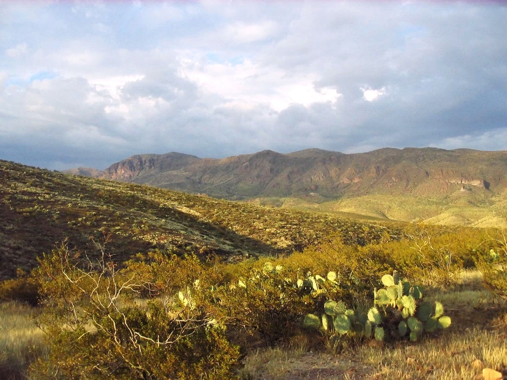
I drove from Chandler Saturday afternoon, meeting Scott and John at the Golden Corral in Safford, where we ate a late lunch and then started our drive in toward the Turtle Mountains, John riding shotgun with Scott in his Chevy Blazer and me following in my truck. We wanted Solomon Pass Road, which begins just west of the Safford Airport (which itself is reached via 8th Avenue, following the signs). We followed Solomon Pass Road steeply up to Solomon Pass, where we had our first unobstructed views of the Turtle Mountains.
Descending north from Solomon Pass, we entered into a broad valley of high desert, unpopulated and looking like it probably did from a hundred years ago. We passed a corral, stayed right at a Y-junction, stayed straight at a 4-way junction (now on Salt Trap Road), passed a small ranch-hand residence, then came to Red Knolls Canyon Road. To here, we had covered about 8 miles from the airport, the roads fairly good.
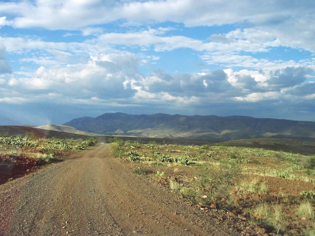
Now on Red Knolls Canyon Road, the road quality deteriorated quickly. The road descends into and out of three small canyons, losing and regaining about 300-400 feet each time. The roads were full of fist-sized chunky rocks, mandating 4-wheel drive. We covered no more than two or three miles on Red Knolls Canyon Road, but did so in 20 minutes, underscoring the slow pace we were forced to take. Soon, we were on a broad bench of land, of high-desert scrub and rock. Next up was a very steep descent into Bonita Canyon, the Turtle Mountains now just across the way.
We got to the lip of the canyon and I immediately backed off, sensing this to be a little much for my truck. It was close to sunset anyway, so we backtracked a few yards and camped amid the brush in a small patch of flat land. There were fire rings in spots, but I suspect more hunters come here than hikers. The night was pleasant, and there were some thunderstorms, with lightning visible, way to the north. However, where we were was dry and uneventful.
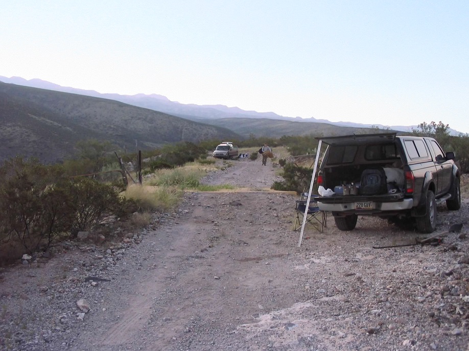
The next morning, I ferried my gear into Scott's Chevy Blazer and locked up my truck. Scott expertly guided his Blazer down the 600-foot descent into Bonita Canyon. A few spots, John had to get out to remove some boulders in the road. The road was a notch worse than what we had driven coming in, but manageable. We were now in Bonita Canyon, facing a ford across Bonita Creek. John waded in to test the depth. It looked promising. The ford was about 30 feet across, a foot in depth. Had we got stopped here, we would have been stranded, although we could have hiked back to my truck to get help. But we made it.
On the other side now, Scott eased his vehicle steeply up the roads, regaining our lost elevation, now on Bonita Creek East Rim Road (according to the map. No signs are placed so far out here). We rumbled north, easing up and down the road, past rocky sections, generally plodding forward at about 10 miles per hour. It was a barely-passable road, and not enjoyable with all the jostling. After covering about three more miles, we parked at Hackberry Spring, close enough for us to walk from here. We started the hike at 7:30 a.m., in cool, clear conditions.
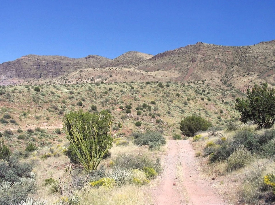
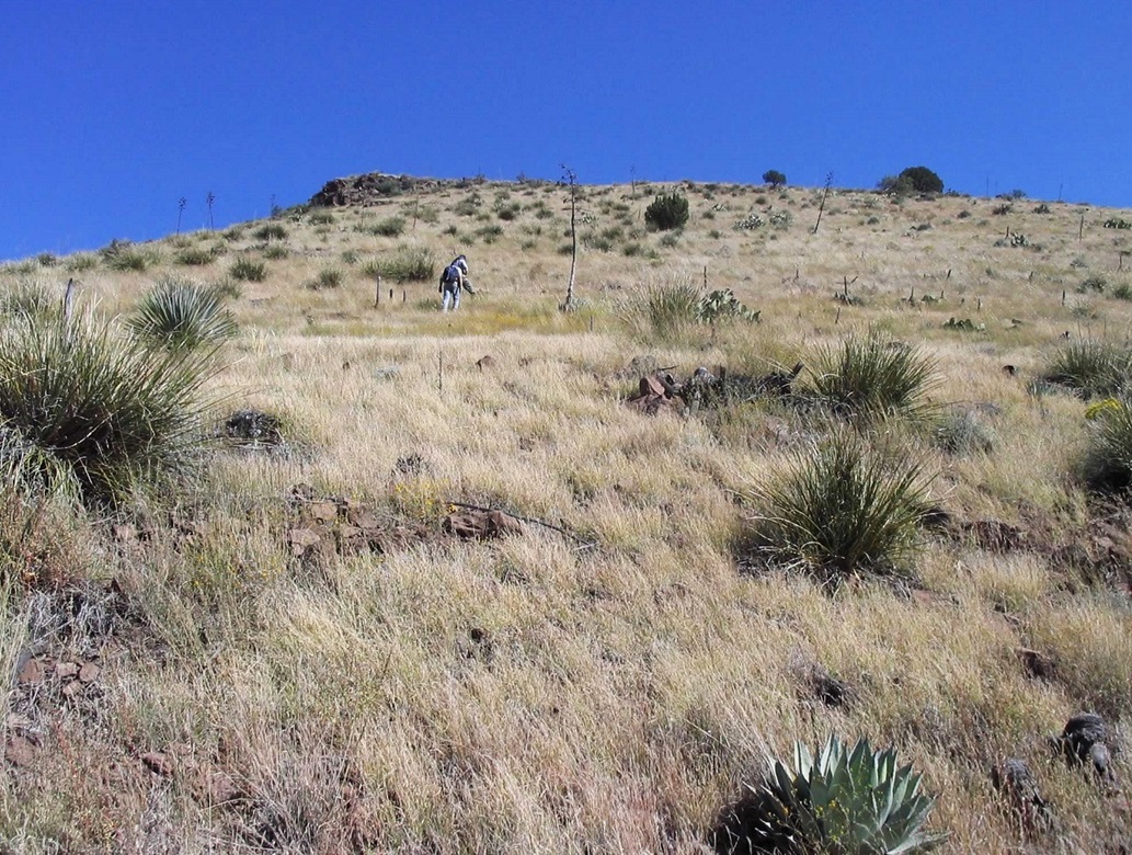
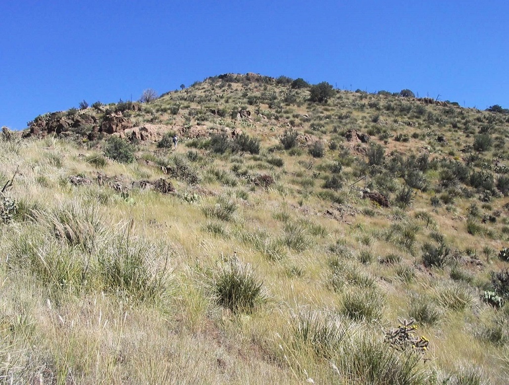
Given all the challenges we had with the roads, the hike itself proved to be very easy. We hiked the road 1.5 miles to Lines Canyon. Making the bend, we could see how the route would unfold: a gently-sloping ridge leads up into mountains, meeting another gently-sloped ramp of open terrain that gains high near some saddles along the range crest itself. Once on the ridge it would be an easy walk north to the summit. This is what our eyes and our maps told us.
We left the road at a convenient spot and started up the slopes to gain the first ridge. This encompassed about 300 feet of steep uphill climbing through thick prickly-pear cactus and lots of loose rock, which would be the theme for the day. Once at the ridge, the slope moderated and we continued east up the slopes through the cactus aiming for an obvious hill directly ahead. After a break, we turned left (north) and started up the ramp. The slopes were very gentle and the cactus had thinned, but the terrain was littered in small rubbly pumice rocks hidden in the grasses that turned and rolled every step of the way.
In time, we all convened at the top of this ramp, directly below the steep slope that led to the saddle. This section only consumed about 300 vertical feet, but it was very steep, brushy, rocky and loose. We each followed our own routes up this section, and Casterlin came upon a baby rattler on his route. I had no such excitement other than slipping at least a dozen times and often having to land on all fours to keep from sliding more.
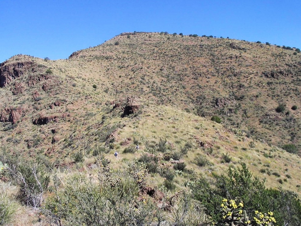
Finally, we were at the top of this slope, sitting in a beautiful open saddle directly south of Peak 6,597. We took another break here. The top was about three-quarters of a mile away. The day was clear and warm but breezy, sometimes strong enough to almost catch my hat but mostly just strong enough to cool us a bit. When it was still we could really feel the heat.
We hiked up the open slopes to gain the summit of Peak 6,597, from which we could see the actual Turtle Mountains Highpoint about a half-mile north. We downclimbed through heavy brush to a lowpoint. The final 500 vertical feet to the summit was better, with open slopes with some natural pathways (game paths?) to follow. John arrived first to the top, then Casterlin, then me, at roughly 11:30 a.m. The terrain was easy, but it had slowed us as you can tell from our times.
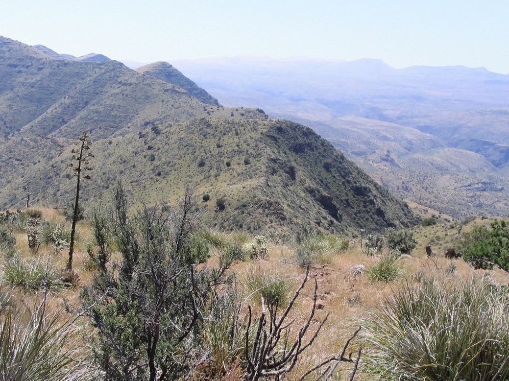
The top itself is grassy, marked by two cairns, and covers a few hundred square feet. The views were tremendous, being able to view big peaks all the way into New Mexico (notably, Whitewater Baldy), and south to mighty Mount Graham. To the north was the open expanse of the San Carlos Reservation, while immediately east we could see the gigantic open-pit mines at Morenci. There was no register on the summit. We honestly have no idea how often this peak is climbed but we surmised less than 10 people a year might see the top. After our slog, we took a well-deserved break up here.
We stuck around the top for about 15 minutes, but the urge to get moving prompted us to start down. We strung out a little bit on the downslopes, following paths when possible but mainly going by sight. We reconvened at the saddle just south of Peak 6,597 and had one more long rest before tackling the ugly steep slope down to the ramp.
The downclimb of this steep slope might better be described as a downslide. Early on I sat on some prickly-pear cactus, getting a glute-full of cactus spines. I spent a few moments yanking the barbs out of my pants and my skin on my backside. I took the rest of the slope slow, and in some places did an impromptu boot-glissade on the rubbly rock. This went fast, and at the bottom we had another short rest underneath some shade trees. From here, we hiked down the ramp to the first ridge, then down that to the road. As usual, John bounded ahead, while Casterlin waited up for me.
By now the slipping and sliding and turning my ankle every step had really fatigued me. The heat of the day also wore on me. Back on the road, we walked our own pace to Scott's Blazer. I was pretty bushed and lagging on this last segment. But we were back to Scott's Blazer at 2:30, a 7-hour hike. Figuring 7 miles round trip hiking, this meant we hiked at 1 m.p.h., not too shabby given the terrain. I was happy to sit and veg while Scott handled the driving back down the steep roads into Bonita Creek and back up the other side to my truck. There, we transferred my gear and we convoyed out the 11 miles or so to Safford, where we all had a good Mexican dinner at Chalo's in downtown Safford. I was home by 8:30 p.m.
It was nice to complete this hike and make the summit, but I think we all agreed that this route really wasn't worth the hassle of the approach roads. The roads are very exposed and steep, and Scott's skill at handling them made all the difference. As I noted earlier, I was not willing to take my truck down some of these roads and probably would have turned around had I been alone. The hiking route was straightforward but the terrain was constantly rubbly.
I would suggest future visitors (both of you) to look into the northern route from Morenci and Smith Canyon, and see how that goes. Eyeballing the east-facing slopes, it looks friendly and probably without much hassle, just brushy. It looks like a longer hike, but the slopes look gentle that way also. In any case, we have it done and I won't likely go back any time soon, but I did have fun and I thank Scott and John for the comradeship on the hike.
|


|