The Mountains of Utah
• www.surgent.net
|
| West Mountain Peak |
• Highpoint: Beaver Dam Mountains • Washington County |
 The Beaver Dam Mountains
|
Date: July 30, 2007
• Elevation: 7,680 feet
• Prominence: 3,640 feet
• Distance: 4 miles
• Time: 3 hours
• Gain: 2,160 feet
• Conditions: Freaking hot
Utah
•
PB
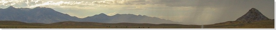
West Mountain Peak is the highest point of the Beaver Dam Mountains in the southwest corner of Utah. The Beaver Dam Mountains are a boundary between the Mojave Desert to the west and south, and the high desert surrounding St. George. βð and I were traveling in the region, visiting the North Rim of the Grand Canyon, plus a night in Kanab. We planned to stay two nights in St. George before driving to Las Vegas to visit my parents. I was attracted to West Mountain Peak for its status as a range highpoint and a highly-prominent mountain. The fact that it has a road to the top helped seal the deal. I was looking for a short workout, not an epic adventure. As things turned out, I got more of the latter than the former.
From Kanab, we drove over the mountains, visiting such places as Cedar Breaks National Monument and Brian Head Peak. On the descent from Brian Head (the town) into Parowan, we were descending a steep grade (12% and greater), when my brakes felt mushy. I pulled to the side of the road to see what was wrong. It took me nearly a half mile to come to a stop, and when I did so, acrid blue smoke rose from my brakes. I had nearly fried the damn things. We sat for an hour to let them cool down. Nothing is more terrifying than trying to stop a vehicle on a mountain road with bad brakes, and barely being able to do so.
After an hour, I looked to see how the brakes were doing. I backed the truck up a few hundred yards along the shoulder, then drove forward, then braked. They worked "normally". But I was taking no chances. I drove the remaining miles down the mountain into Parowan by driving slowly in the shoulder, hazards blinking and the truck in low gear. People behind us seemed to understand something was not right, so they were patient and would pass when there was a chance for me to pull completely aside.
Once down the mountain, I sped up a little more, then would test the brakes by slowing down, and a couple times, getting off at a rural exit, stopping, then right back on. They seemed to work. I got us into St. George without further mishaps. However, first thing tomorrow (Monday), I would get them checked out at a brake shop in town.
Next morning, I drove to a brake shop for an inspection. They said it all looked good, just a tiny bit glazed. Trouble was, it was pushing 9 a.m. by the time I got my truck back, and it was getting hot. Back at the hotel, we talked about what to do. I still wanted to go hike West Mountain Peak. βð had lost interest, and I suspect she was enjoying the air-conditioning and amenities of a hotel room after so many days camping. She allowed me to go on my own.
Driving west along St. George Boulevard, I went north when the road ended, then west again on state highway UT-18 through the town of Santa Clara, then skirting Ivins to the Shivwits Paiute Indian Reservation, about 20 miles west of St. George. By this time, the land forms and colors had changed noticeably, becoming less red and more tan, less cliffy and more rounded, less "Utah-like" and more "Nevada-like". The road bends left and starts trending southwest. Although not marked by any road sign, this road is old US-91, which pre-dates modern Interstate-15. I drove on this road about 6 miles, then found the access road into the range about a mile south of the Shivwits Reservation boundary sign. The access road is called Hell Hole Pass Trail on the maps.
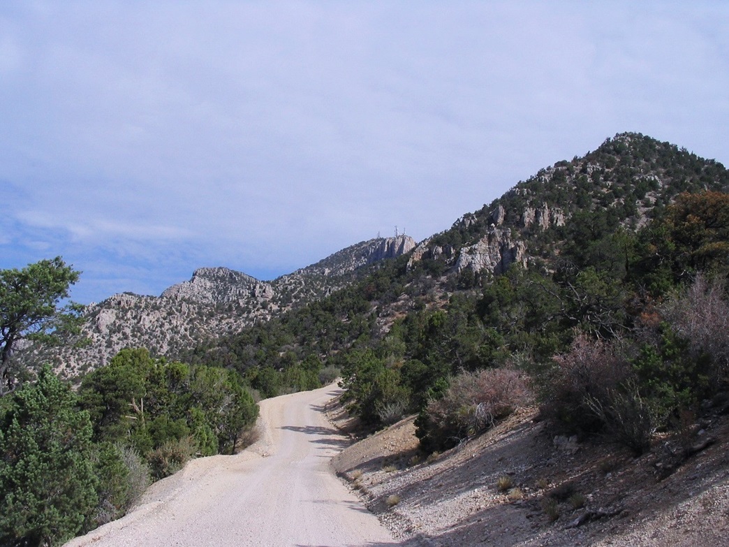
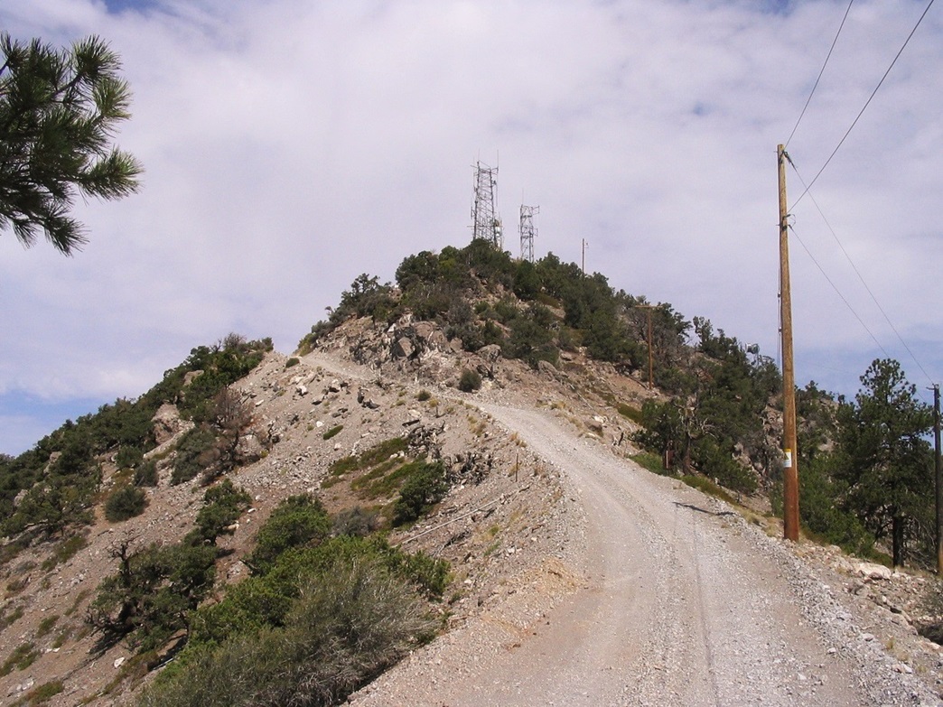
Hell Hole Pass Road is good and regularly maintained because of the towers that sit atop West Mountain Peak. The road gets steep about a mile in, then rises and drops twice before making a steep push to the pass itself, 4.5 miles from the pavement. I parked in a pullout near a barbed-wire fence. The "main" road dips to the left, heading toward Indian Springs, while the better-looking "side" road, goes right, a signed telling me the towers are 2 miles away. I was at 6,240 feet elevation, but it was quite warm. It was 11 a.m. when I got all my stuff together for the hike. I would be traveling light, carrying a bunch of waters and some snacks in my pack.
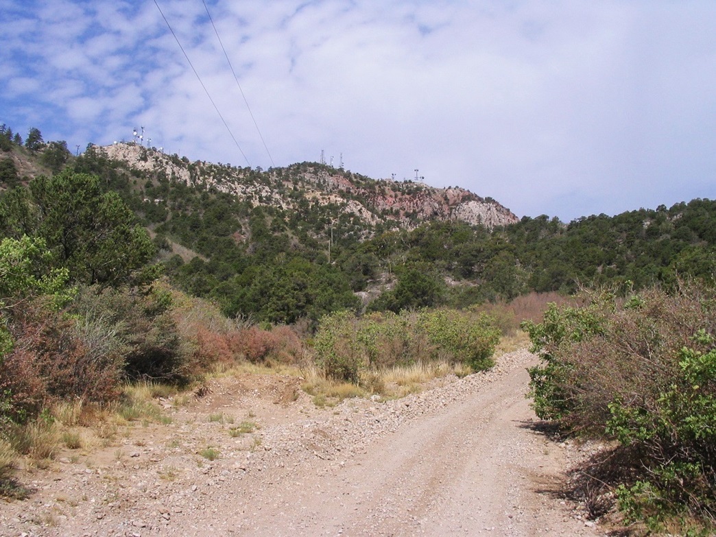
I walked up the road as it bent right, at which point the towers were now in view. That was nice: just a few hundred feet of hiking and I could already see the finish line. The road then steepens, and stays fairly steep, for the next three-quarters mile, gaining 700 feet to a pass near power lines. The hiking was simple, but laborious. Now and then a breeze would kick up and cool me, but otherwise, it was getting hot and uncomfortable.
After the pass the road dropped ... a lot. I was happy to have some downhill to rest my legs but was alarmed how much it dropped, 240 feet according to the map, because I knew this would be unwelcome uphill hiking coming out. I made good time to the lowpoint, where two work trucks drove by, on their way to the top to the towers. At the lowpoint, I had about 950 feet of gain to the top, in what I figured was about another 3/4 of a mile. In other words, steep. I continued on.
I trudged upward, one foot in front of the other. All went well until halfway up, I bonked. The heat was really getting to me. It had been 106 degrees in St. George the previous day, and it felt like the mid-90s already on the trail here. There was no shade nor breeze. I wobbled to the top-most ridge and walked the remainder of the road to the summit hill. I tagged it the cairn, then turned right around for the hike out.
I had great views looking south and west as I hiked down the road. The views are impressive, with almost 5,000 vertical feet between the summit and the deserts to the west. Looking south I saw Scrub Peak and farther on, the Virgin Mountains. To the North and East, I saw thunderstorm clouds forming, although above me we had nothing for the time being.
The 950-foot descent to the lowpoint of the trail took 15 minutes and was easy, but the 240-foot uphill part slowed me. I took a couple breaks but the heat was really getting to me. At one point one of the work trucks was now coming down, and I considered asking him for a lift, but I didn't. Despite the discomfort, I wanted to make it out on my own. The last 700-foot descent took another 15 minutes and shortly, I was back to my truck, totalling an hour for the descent.
I was thrashed. I didn't even change into dry clothes or out of my boots. I just piled in and drove down. My truck's brakes worked great, happy to say, and I was back onto pavement in about 15 minutes, then back to Santa Clara in another 15 minutes. I was dehydrated and extremely uncomfortable. Once in town, I stopped at the first Stop-&-Rob and bought a 32-ounce Gatorade, which I drained in just a few minutes. That seemed to do the trick. My tummy settled down and I felt a lot better.
I was back to the hotel at 2:30, the day already nasty hot, about 104 degrees, give or take. βð was guarding the fort in the hotel room, with the air-conditioning blasting. I took a dip in the hotel pool and watched as the big thunderstorms started to build. After a shower, we ate again at the Chuck-a-Rama, then got back to the hotel room to watch the lightning, dust and rain come in.
Last comments on the hike: Overall it was easy, but steep. I would tackle this first thing in the morning during summer, to take advantage of the cool mornings and better light effects. It looks to be a pretty fall hike, possibly. However, a mid-day summer hike can be rather hot. Even at 7,000 feet, it gets very, very warm.
|

|