The Mountains of Utah
• www.surgent.net
|
| Deseret Peak |
• Highpoint: Tooele County • Highpoint: Stansbury Mountains • Wasatch National Forest |
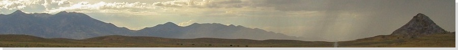
 The Stansbury Mountains with Deseret Peak to the left
|
Date: August 12, 2003
• Elevation: 11,031 feet
• Prominence: 5,812 feet
• Distance: 7 miles
• Time: 5 hours
• Gain: 3,600 feet
• Conditions: Clear, spotty clouds, windy at the ridge
Utah
•
PB
The highpoint of Tooele County is Deseret Peak in the Stansbury Mountains, 40 miles west of Salt Lake City. It is the last big range heading west before the salt flats of the Great Salt Lake Desert come into view. I was finishing a five-day "extended weekend" of peakbagging in northern Utah and in Idaho, with the biggest catch being the Idaho state highpoint, Borah Peak. Yesterday, I hiked Naomi Peak, then drove back toward Salt Lake City with most of a day to kill. So I visited the Great Salt Lake itself. This would be my second visit to this interesting sea, my first being in 1990.
On the 1990 visit, I wanted to test the theory that I could float on the water, given the sea's dense brine. I parked at the Saltair complex and walked out to the shore, then into the water a few hundred yards. It immediately wasn't going well. The sea is shallow, and I was still only up to my shins. The bottom was an awful goo of warm mud that felt like I was walking in soft smelly fresh gushy gooey poo. There were billions of tiny brine flies buzzing the water and me, and the smell was unbelievable. I grew a brain and stopped this quest, returning to the Saltair and washing off the salty muck from my body using outside showers. I was content to admire the sea from a distance.
Here I was again, thirteen years later. I had no desire to walk into the water again, but still wanted to explore the place. I parked again at the Saltair. It is a pavilion sitting astride the sea. Depending on the sea's level, it can be beside the sea, or over a mile from shoreline (or, rarely when it's been a wet winter, flooded, as it was in 1983). The Saltair seems to have been built with the intent to host big dances and parties. It has a big interior room, but little else. It was in disrepair. The electricity was off, and the snack bar sold its drinks out of an ice-filled cooler. The bathrooms didn't work either.
Nevertheless, I still thought it would be amusing to walk to the shore. This time, it was about a half-mile away. The surface to it was a salt-hardened crust akin to a sabkha. It was mostly solid, but sometimes I would step through it into soft mud. There were flies, and it smelled horrible. Up ahead, I could see people lounging on blankets and in chairs, like this was a normal ocean or pool. Judging by the cut of the swimsuits, some were clearly Europeans who didn't know any better. What was I going to do once I got to the shore? Float? I decided to stop this quest and returned again to the Saltair. I spent about three hours here, and at least was able to kill off part of the day. In the late afternoon, I drove west toward the towns of Tooele and Grantsville, in the Rush Valley.
The Rush Valley is hemmed in by the Oquirrh ("Oker") Mountain to the east, and the Stansbury Mountains to the west. The town of Tooele comes first, but Grantsville is closer to the Stansburys, so I drove out there, only to discover they had no lodging options. So I drove back to Tooele and stayed at a motel in town along Interstate-70. It was hot outside, there were trucks everywhere, and my dining options were whatever the nearby minimart had available. In other words, heaven.
Early the next morning, I drove to Grantsville, then south on another road toward South Willow Campground. About 4 miles from Grantsville, I turned right (west) at a junction into the range. The road was paved for the first 3 miles, but the pavement was horrible. The dirt road at the forest boundary was actually much better. I drove this dirt road another 4 miles through interesting narrows to the Loop Campground, where the Mill Creek Trailhead is located. I arrived at 7 a.m. in slightly breezy, slightly cloudy conditions. I was the only person there (no campers). I started hiking at 7:15 a.m.
The route to the summit is 3.5 miles one way with about 3,600 feet of elevation gain. This was just three days after my Borah Peak climb, which gained 5,100 feet in the same 3.5 miles, so by comparison, this hike would be easy. The first half-mile gains moderately, staying north of the Mill Creek drainage, makes two switchbacks, then crosses the creek itself. A junction in the trees immediately follows. I went left, as the sign indicated. Here, the trail was level, but then it began its consistent upward grade again. The next two miles gained about 2,100 vertical feet to achieve the main ridge at elevation 10,042 feet. This stretch was pretty, with meadows hemmed in by enormous cliffs and ridges.
The gradient never got too steep and I was able to make good time. Only the final 100 vertical feet, where the trail is loose, was mildly troublesome. But I had one really neat event: as I hiked, I heard rustling and a loud "voosh": a huge, gorgeous eagle alighted from a nearby tree branch and flew right by me, close enough that I could have reached out and grabbed him. I watched him fly and soar. Wow, he was impressive. I applauded him! Moments later, I reached the main ridge where I quickly got nailed by heavy winds. I took refuge in a small stand of trees about 200 feet to the right (northwest, roughly).
The trail continues up and contours across and around back of a small foreground peak. For much of this stretch the winds were howling. Once "around back", the trail switchbacks up the west face of the main summit mass, coming around one small bend, by which time the actual summit is visible, the first time I saw it on the whole hike. I arrived on top just before 10 a.m. The winds were strong and it was cloudy, but clearing. I enjoyed the beautiful views, especially nice to the north and south, and snapped a couple of photos. There's a small rocky dugout/wind shelter, but I could not locate a register nor the benchmark.
To the north are a pair of impressive peaks that I though were the summits (one of them, at least) as I hiked up the main ridge. In fact, from the desert floor below these look like the summits, but they're not. See my photo at left for reference. I centered these peaks, thinking they were the top, but the true summit is to the left.
After 15 minutes, I started down, meeting up with a man and his two grandchildren at the ridge. I made excellent time down these trails, which were steep but rarely too steep -- the right gradient for me to jog-walk. As a result, it took me just 90 minutes to exit, coming back to my car at 11:30 a.m.
My flight out was later that day, and I needed to clean up. I went to the truck stop near the motel I had stayed at the night before, and lucked out. Someone had paid for a shower, then bailed, so they let me use it for free. I spent a couple hours driving aimlessly in Salt Lake City, then to the airport for the flight home.
I also learned how to pronounce "Tooele". They say "To-willah" or "Twillah". To the south is the giant Tooele Military Reservation.
|

|