
Idaho
• www.surgent.net
|
| Borah Peak |
• Highpoint: State of Idaho • Highpoint: Custer County • Highpoint: Lost River Mountains • Salmon-Challis National Forest |
|
Date: August 9, 2003
• Elevation: 12,662 feet
• Prominence: 5,982 feet
• Distance: 7 miles
• Time: 11 hours
• Gain: 5,260 feet
• Conditions: Fantastic
• Teammates: Adam Helman and Barney Metz
Main
•
PB
•
LoJ
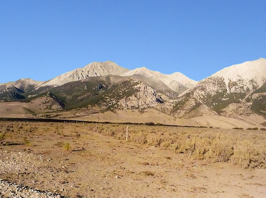
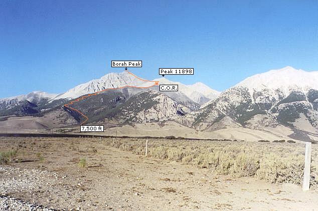
Borah Peak is in the Lost River Mountains of central Idaho and is the highest point in Idaho. The peak has a well-earned reputation as a tough, all-day grind, gaining nearly a vertical mile from trailhead to the top. The hike is short, about 7 miles round trip, but steep, and includes a challenging knife-edge section called the Chicken Out Ridge (COR). While the hike is not technical, it is challenging, and the COR can scare people off, as it did me in 1996.
On that 1996 attempt, I was here with my college friend, Jen (Mount Whitney '92). The trip started with a bad omen: I got a speeding ticket while driving into Arco, the main town in the area, about an hour south of the peak. I was about 5 miles per hour over the limit, but Hank the cop was a stickler for speed limits. Fortunately, the ticket was just $40. Later, while Jen and I ate at a cafe in Arco, Hank came walking in. It was apparently his favorite cafe.
In 1996, I was still confining myself to peaks with trails, and although I was aware of the challenges of Borah Peak, I was curious to discover how well I would do on the scramble sections. The hike itself up the steep slopes went well, but when we encountered the Chicken Out Ridge section, Jen and I both CO'd. We had been joined by another hiker, Dave from Texas, who was nearing his 50-state completion and badly wanted to complete Borah Peak. The three of us stood around at the base of the COR, wondering if we'd run up a dead end.
About this time, two women came hiking up, and one quickly scampered up the initial rock slope of the COR, while her friend stayed behind with us. The first girl talked Dave up the slope and they hiked as a pair to the top, while Jen and that other lady walked back down with me. I was bummed, but knew that we had made the right decision. Jan and I consoled ourselves with a day trip to the Craters Of The Moon National Monument nearby, walking the lava fields and tubes for fun, and looking out for snakes.
For this attempt, I was joined by Adam Helman and Barney Metz, the latter an Idaho native. In the intervening seven years, I had gained experience on cliffier, rockier peaks and felt better prepared to handle the Chicken Out Ridge. I flew into Salt Lake City rather than Boise (same distance, cheaper price), and spent the previous day on a conditioning hike up Bridger Peak in Utah. From there, I drove to the Borah Peak trailhead and campground, arriving in mid-afternoon.
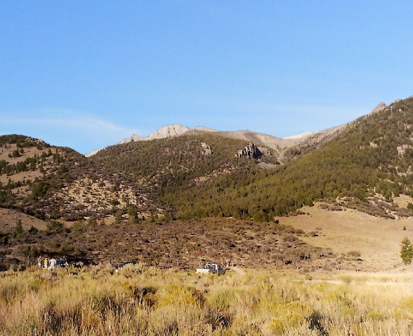
I was to meet Adam and Barney here, but they were running late. I spent most of the day walking the parking & camping area, psyching myself up for tomorrow's big hike. No storms had developed over the peak, which was a good sign, suggesting stable air for possibly the next few days. Adam and Barn didn't arrive until well after dark. We made introductions, chatted a little bit, but then got busy sleeping, me somehow stretching out in my rental Oldsmobile Alero sedan.
We arose at 4:45 the next morning, the sky a deep purple tint. We were hiking by 5:25, getting the early start knowing we would be spending most of the day on this endeavor. I "led", deliberately trying to keep a slow but consistent pace. Adam and Barney fell in behind and we made steady progress up a small canyon, topping out near a knob, elevation 8,714 feet. To here, we walked three-quarters of a mile and gained 1,100 feet in 50 minutes. We took a break at this knob. Soon, other hikers were showing up, a few bounding up the slopes like gazelles. Where these people store their third lung, I'd like to know.
After our rest, we resumed the upward trek, gaining another thousand feet in 45 minutes to a rest-stop near a single lone fir tree, one of the last big trees as we neared tree line. Above tree line, the trail continues steeply upslope, then finally moderates for a small segment, roughly a half-mile, where it runs along a ridge. A small stone-wall shelter is nearby, and in places the trail even dropped slightly.
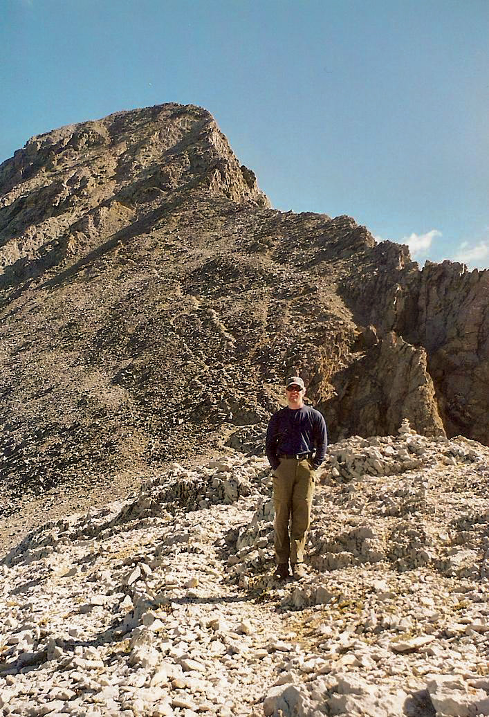
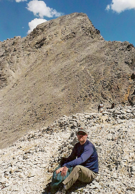
Borah Peak's mass was still looming high to the north, over 2,500 feet above us. To the south, the terrain was sloping fields of talus. To the north was a giant cirque ringed by cliffs and containing lots of glorious air. Above us, the route seemed to steepen to near vertical, but we knew this was a trick of the eye. Upward we marched.
As we gained this seemingly vertical section, we found it to lay back nicely, with the trail worming its way up through the talus and small rock bands, growing weak and hard to follow in areas. The next immediate goal was an obvious cleft in the skyline above us. We hiked to this point, roughly 11,300 feet elevation, a 3,800-foot gain since we started the hike a few hours earlier. Here, the trail "ends". This is the base of the Chicken-Out Ridge.
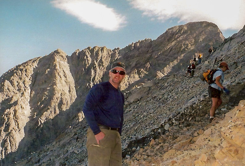
Jen and I hiked to here with no problem back in 1996, but the exposure spooked us. Plus, we weren't sure that were we even on the right track. We thought we missed a turn or something. For a number of years afterwards, this bugged me: had we been in the right place or not, and if not, why not? Well, we had been to the right place. But seven years of climbing since then had gained me a tiny bit of knowledge and bravery, enough so that I could will myself up the initial sloping rock that marks the start of the COR.
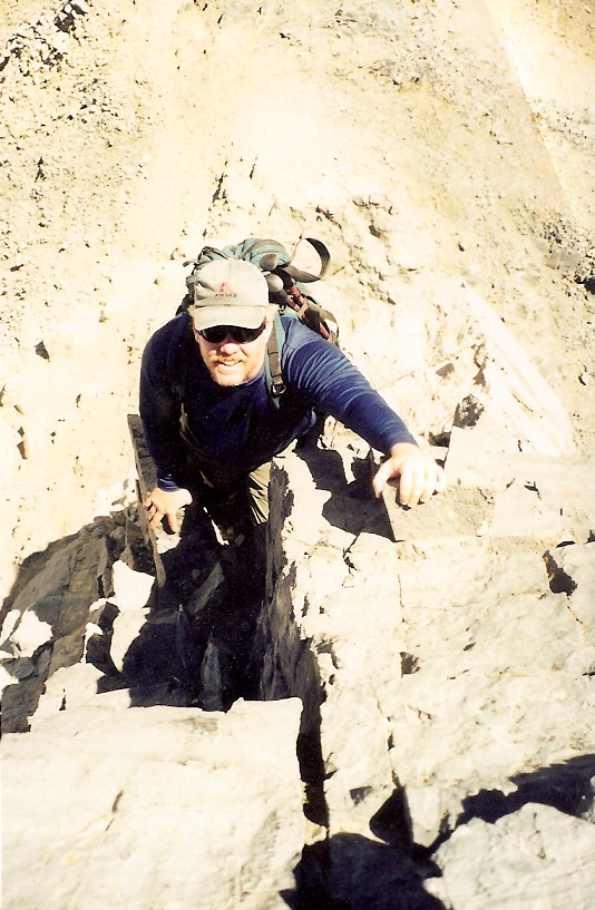
Here's where a nice bit of luck fell our way: a couple were standing at the base as we were, but they had hiked the peak before and knew the nuances of this section well. With their guidance, we easily scampered up the rock and across the small section of exposure to place ourselves back onto a wider ledge, and again on the trail. We all hiked up this trail as it surmounted a hump, then down the other side. The real crux of the crux, a steep-walled notch, still lay ahead.
We followed the trail as it traversed about 100 feet to come to the base of a chute, the slope about 40 degrees, but with the rocks set solidly. Looking up it, it was no problem, Looking down, it was 2,000 feet of air. We all climbed up the notch, Adam and Barney eventually topping out about 60 feet above us. Meanwhile, the couple pointed out a scanter side trail to our left (as we looked up). They followed it, so I did too. This segment covered just a few dozen feet but was sloppy and loose, and I didn't enjoy it. But it had one positive result: it placed us in the notch, thereby bypassing the 30-foot rock downclimb that one normally takes to get into this notch (and what Adam and Barney did).
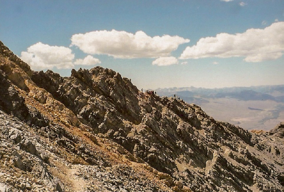
The notch is often filled with snow, even into early summer, but now in August, there was no snow. Thus, it was trivial to cross this notch and gain the slopes beyond it, once again on wide trail. We were now past the Chicken-Out Ridge, and closer to our goal. Borah Peak still stood high, but now just about a thousand feet higher. And the good news was that a trail leads almost all the way to the top. The trail traversed left of Peak 11,898 and came to a saddle below Borah's mass. The trail snaked up its southwest face, and looked like a real grind. But, in truth, it was easy.
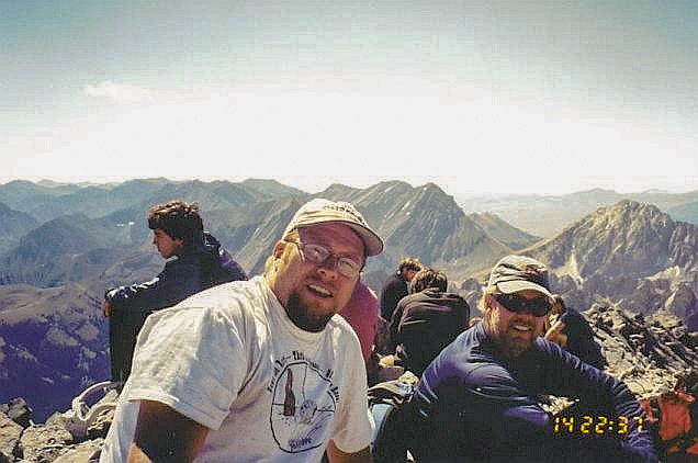
We strung out a little here. Adam and Barney went up ahead. Me, I got about 200 feet below the top and tiring of the looseness of the trail, opted to scramble right and up firmer rock sections to gain a ridge, approaching Borah Peak's bare top from the south. People were sitting about enjoying the summit and the views, and no doubt, the well-earned rest. I found a spot beside Adam and Barney and rested myself, happy (and just a little bit surprised) to be successful on Borah Peak.
It had taken me nearly 6 hours to gain the summit, which (according to a sign at the start) is about average. The weather was still and calm, just a few clouds here and there, but nothing threatening. I enjoyed the break and the incredible views. But truthfully, my mind was fixated on descending back down the Chicken Out Ridge. I wouldn't really be able to enjoy the success until I was below that section. Thus, when Adam and Barney clamored to get moving, I fell in immediately.
The downclimb was easy but tedious, and the trail directly below the summit was loose. But it presented no challenges and in time we had descended to the notch above the COR. We walked into the notch and waited while hikers on the ascent were coming down the rock wall from the other side, or us on the descent waited for a chance to scale this wall. I had bypassed it on my upclimb, but wanted no part of that messy trail I mentioned earlier. Besides, the wall looked like fun and not as bad as I had feared it to be.
Adam and Barney were about 10 minutes ahead of me and had already climbed this wall (we had agreed to meet one another below the COR's lowest section). I stayed with some other people and studied the route as hikers scampered down or up the wall. Thus, when it was my turn, I knew where to go and I was able to get up the wall in just a minute. The wall rates easy class 3, but it's the exposure and the huge voids of air below that mentally spook people. The actual climbing was easy.
Above the wall, I walked a few feet to get to the top of the chute, then carefully downclimbed it, now looking down at the two-thousand feet of cliffs and air below me. But as mentioned before, the rocks were solid and as long as I took them one at a time, I did fine. I used the five points of contact technique often. Once at the base of the chute, I followed the trail left to the top of the initial rocks of the COR, and was able to get down these, where Adam and Barney were sitting enjoying a break. Only now could I relax. The worst was behind (or above) me.
With a good trail from here on down, we felt no real need to stay clumped together, so the three of us hiked at our own rates, agreeing to meet up "later", presumably at the cars. This was fine by me, but after about a half hour, I realized I was in for some potential trouble: I was low on water. I had packed a lot, but ran through it faster than expected. Adam and Barney were off ahead of me so they couldn't help. I had a liter remaining.
I made it down to the trees but was lagging. I probably could have made it all the way out with what I had, but about this time, a guy I had talked to up high came walking down past me and I asked if he could spare me some water. He was happy to give me a full bottle and thereby lighten his load in the process. Having this extra bottle helped me a lot. The rest of the downhike was tiring, dusty and boring. I stumbled out to the cars at 4:30 p.m., tired but happy. Adam and Barney had been out about 30 minutes and once they were satisfied I was good to go, they drove to the town of Mackay, where I agreed to meet up with them after I rested and changed.
In Mackay, I rewarded myself with Stewart's Orange and Cream soda and other liquids. We then convoyed to the interstate to the town of Burley where we ate a meal, before driving south to the City of Rocks State Park, where we camped for the night, in preparation for the next day's short hike and drive up Bull Mountain in Utah.
It had been a successful summit day and the weather had behaved for us the entire time. My thanks to Adam and Barney for being good partners and everyone else on the hike who helped one another through the rough bits. In retrospect, I'd have to agree with all the advice I'd heard about COR: always stay high. Other than that, it was just a very steep hike. The views were magnificent, and it was a beautiful climb all the way around.
|


|