The Mountains of Utah
• www.surgent.net
|
| Bull Mountain |
• Highpoint: Box Elder County • Highpoint: Raft River Mountains • Sawtooth National Forest |
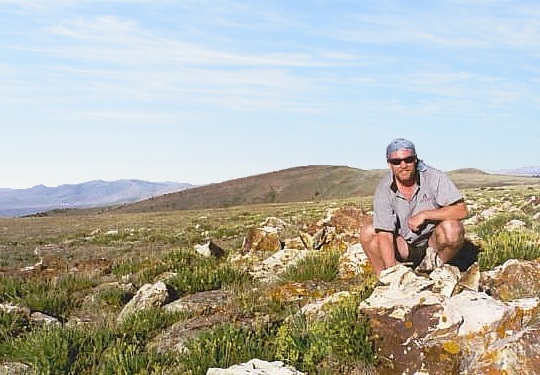 Me at the eastern highpoint. The rise behind me is the other highpoint area but is lower by a couple feet
|
Date: August 10, 2003
• Elevation: 9,930 feet
• Prominence: 3,725 feet
• Distance: 0.2 mile (walk)
• Time: 3 hours total
• Gain: 50 feet
• Conditions: Sunny and high clouds
• Teammates: Adam Helman & Barney Metz
Utah
•
PB
Bull Mountain is the highpoint of the Raft River Mountains in northwest Utah, near the Idaho boundary. The two common ways to reach the summit is a long trail from the east or a beat-up 4-wheel drive road from the west. The day before, Adam Helman, Barney Metz and I climbed Borah Peak, an all-day hike. We came down tired and sore. A day off from hiking is really what we needed, and so we decided to drive the rough road to the top of Bull Mountain, rather than hike.
From the Borah area, we convoyed for a meal in Burley, then I followed Barney and Adam through miles of gravel roads, not having any idea where they were actually going. This went on for quite some time. We ended up at the City of Rocks State Park, where we car-camped for the night. The City of Rocks features large granite rock outcrops, popular with climbers and campers. However, we were the only ones here this night, it being quite hot. As sore as I was, I slept poorly, trying to stay cool and stretch out in the front seat of my rental vehicle. I got about 4 hours of half-ass sleep.
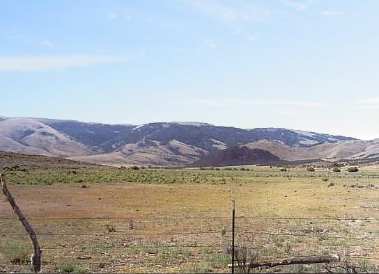
Early today we got moving, with Barney leading the way and me following. Barney's an Idaho native and knows all the backroads, so I followed trustingly, but I never had a strong idea of where we were heading. We just drove and drove through high-desert hinterlands, at some point popping into northern Utah, rolling into the community of Yost. This put us on the western foothills of the Raft River range. It was still early, and the only activity in town were the various dogs barking at us. We didn't see any people.
We continued driving, working our way up some steep roads into the mountains, reaching a spot where my little rental could go no farther. I found a secluded pullout and stashed the vehicle there for the time being, and sat in the back of Barney's beefy truck. Adam was shotgun and navigator while Barney handled the driving. Me, I was ballast. As sore and tired as I was, I had no objections whatsoever.
The drive covered another ten miles or so. The roads were rough, but not impossible. A few places the roads were cut into the hillsides, but mostly, we had broad and open ridges with no forest cover, so the views were superb. We arrived at the presumed highest point of the range about 9 a.m. in clear, warm and sunny weather. We got out and milled around, tagging the highpoint rocks and getting a photo or two (the one on the left sidebar of me was taken here). Everything was calm and peaceful. I didn't feel that guilty for being driven all the way to the top.
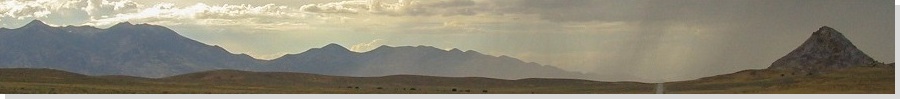
After a few minutes, we piled back into Barney's truck and rumbled back, stopping again at another rise, another possible contender for the summit of the range. We had to park below it and walk the easy slope to the top, where the USGS benchmark "Dunn" sits encased in concrete and rocks, covered by wooden remnants of an old triangulation apparatus. I did not attempt to reach into this mess to tag the benchmark, given the spiders or snakes that probably live here.
This visit took just a few minutes and with that, we were done. We drove down the roads to my vehicle, at which point I bade Barney and Adam farewell, thanking them for a fine hike up Borah and a fun drive up Bull Mountain. It had been a very successful 24 hours with those guys. They went off into Idaho to tackle some more peaks up there.
Me, I was so tired I couldn't see straight, not to mention filthy. It was still early, maybe 10 a.m., so I drove back into the populated parts of northern Utah, stopping for the day in Logan where I got a hotel room. It was too early so I had to kill time, so I found an old bookstore in town that had all sorts of authentic 19th-century Mormon literature for sale. A lot was fascinating and downright strange, but expensive too. Once my hotel room opened up, I showered and crashed, doing not a damn thing the rest of the day.
Sufficiently rested, I spent the remainder of my time up here hiking a couple more peaks, starting with Naomi Peak in nearby Cache County the following morning.
|
|