The Mountains of New Mexico
www.surgent.net |
| Eagle Peak |
• Highpoint: Tularosa Mountains • Gila National Forest • Catron County |
 Eagle Peak
|
Date: May 24, 2007
• Elevation: 9,786 feet
• Prominence: 2,266 feet
• Distance: 4 miles
• Time: 2 hours and 30 minutes
• Gain: 1,120 feet
• Conditions: Sunny and dry
New Mexico
•
PB
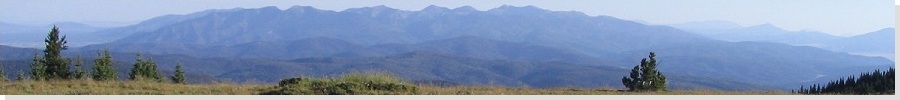
Eagle Peak is the highest peak in the Tularosa Range in western New Mexico, near the interesting little town of Reserve in Catron County. A good gravel and hardpack dirt road leads from the highway to the base of the peak, while a lesser road goes all the way up to an active lookout tower. Our plan this trip was to stay a night in Reserve, visit Eagle Peak, and double back into Arizona for more camping in Greenlee County.
We left our home and went the northern route, following the highways through Payson, Show Low and Springerville into Alpine, then from Alpine into New Mexico through Luna and finally Reserve. Luna itself wasn't very interesting, mostly scattered homesites over a wide area, with about 200 people in it. However, the drive into Reserve was scenic, highlighted by a bear sighting. A black bear was ambling along the highway as we rounded a bend. We saw him and he saw us before taking off into the trees. We rolled into Reserve about 7:30 p.m., staying at the Rode Inn, barely in time to catch the 2-hour season finale of Lost.
Reserve is the county seat and only incorporated municipality in Catron County, but its population is only about 300 people. The town is a T-intersection of two highways, with everything situated along the two highways, including the two-story Catron County Courthouse next door to the grocery and diner, and across the street from the hotel. The town's population live in homes scattered on the fringe, and the biggest employer seems to be the Forest Service. I asked the hotel clerk if they get busy on Memorial Day weekend, and he said "only when there's a fire". In fall, hunting is the big activity: the main restaurant in town has a wall full of photos of hunters and their catch. This is all amid rolling hills and mountains, while and the San Francisco River cuts through the north end of town. It's all very lovely.
The next day, we got moving around 8 a.m. in calm weather. The morning was very cold (in the 30s) but once the sun was up, it warmed fast so that by 8 a.m. we didn't need jackets anymore. After gathering provisions at the grocery across the street, we hit the road. We followed highway NM-12 north and east out of town for two miles, coming to the Gila Forest Road 233 access, signed with "Eagle Peak L.O. 18 miles". In we went.
The road descended into a lovely canyon toward Tularosa Creek. Part of this land is private. some areas were fenced, and there were cattle in one area, and some horses in another. The canyon walls were sometimes sheer, with interesting rock formations. The road fords the creek, then gained steeply up the side of a mesa, where excellent views. Then the road surmounted the mesa, and for the next three miles, the road was flat and straight, passing through a pinon and juniper forest. The grasses were green and the whole place looked like a park. In time, the road started to gain elevation, and after 12 miles (according to my truck's odometer), we came upon the junction with Forest Road 38, and a sign pointing to Eagle Peak, "5 miles".
Eagle Peak itself was mostly invisible along our drive in, blocked from view by foothills and forest. At the FR 233/38 road junction, we could make out distant peaks looking up the canyon, although trees blocked most views. We angled onto FR-38 and started up the narrower road. I put the truck into 4-wheel drive for the handling. We drove a mile to where FR-38 flattened out at a wide clearing. We decided to park at the next best wide area we came upon. We were able to get another mile up the road, parking at approximately 8,660 feet. There was a pullout here, just wide enough for me to do a 15-point U-turn here to orient the truck downhill and off the main track.
βð decided that she would not be able to go on the hike. The area looked safe and it was evident this road saw little traffic, especially on a weekday. We set a chair up, got the cooler handy, and she was good to go. The weather was superb, and we felt this was a safe environment. Just in case, we had pepper spray handy, plus she kept the truck keys and could drive down if things got nasty.
I got suited up for the hike. Whatever cold I had caught in California was still with me, so while I generally felt okay, I still had a nagging cough and a general malaise. The hike itself looked doable if I went slow. The distance looked like two miles each way and 1,120 feet of gain, all of it on road. I started hiking, and within minutes I was keeling over, coughing and wheezing, barely able to catch my breath. After I rested a minute or two, I made sure to go real slow. This worked well. I still didn't feel great, but I could keep a slow pace if I didn't rush things. Interestingly, once I got into a good breathing and hiking regimen, my cough subsided, and only returned whenever I took a break.
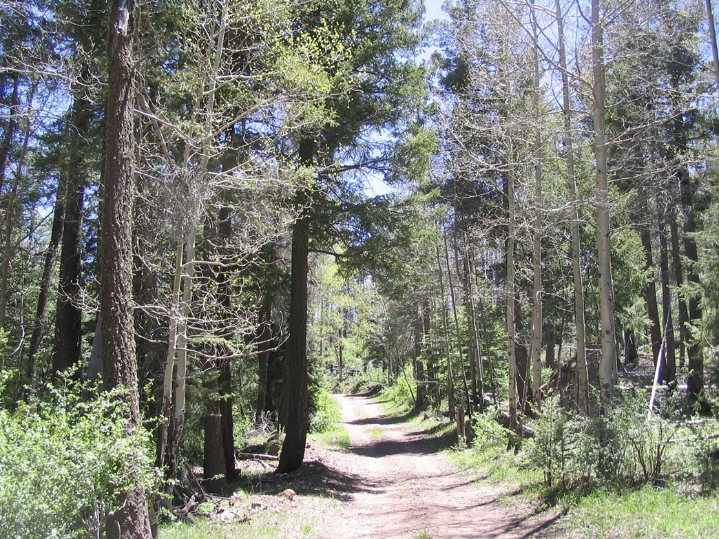
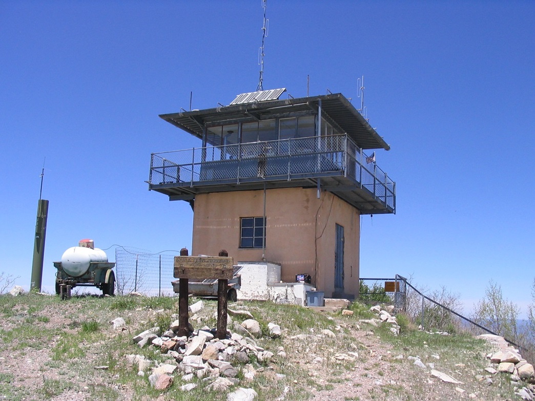
From the truck, I followed the road a half-mile to a bend where I had good long-distance views of the summit, including the lookout tower. Fortunately, the road was pitched at a lenient grades, and by going slow I did well. I lost sight of the summit again in the trees, but quickly came to an open gate (closed if the tower is not in use).
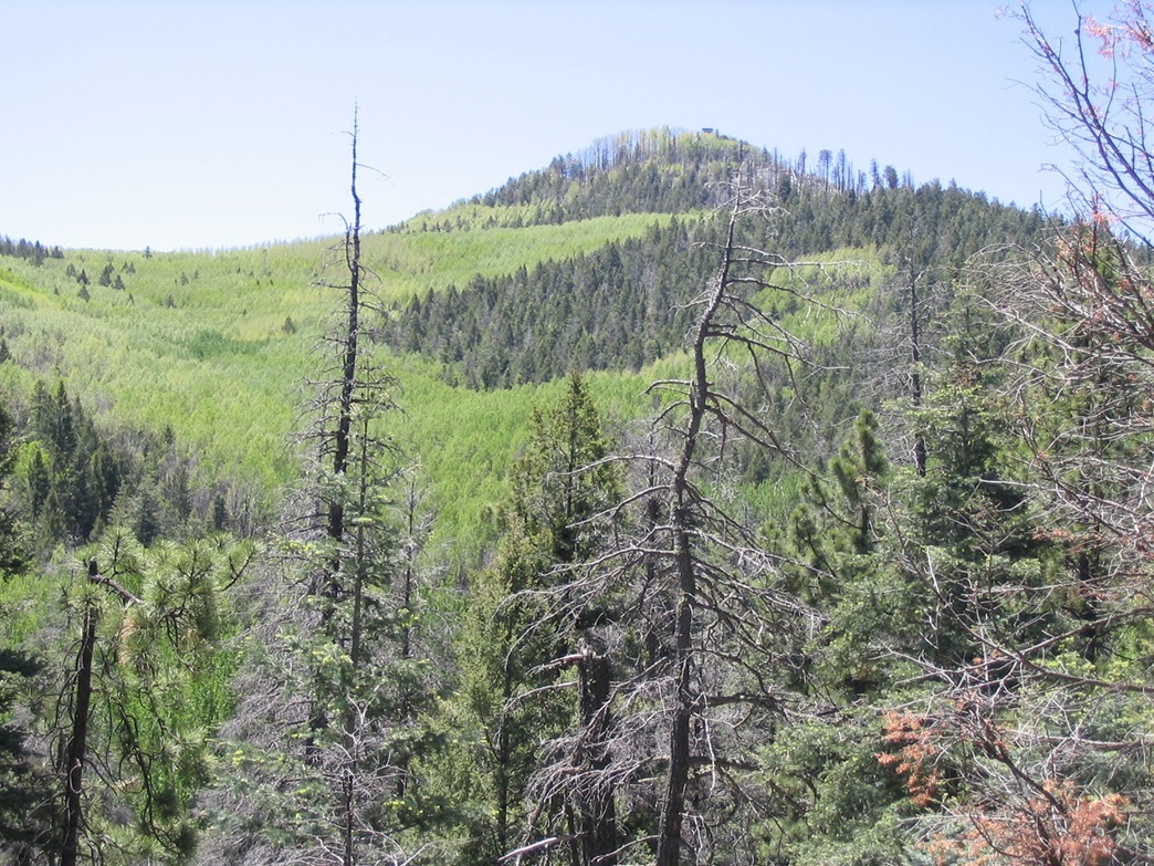
After the gate, the road steepened and switchbacked a couple of times, then cork-screwed up to the summit. The lookout guy saw me and said hello as I came upon the top. He invited me to come up for a visit, which I did, escorted by his dog Shadow. From the lookout tower, the vantage was fantastic. The man's name was Skip, and he was the relief guy, spelling the regular guy. Skip was doing a 3-day stint atop the peak. Nice guy. He described the big 1995 burn that swept the range and some of the summit.
From the top I could see sections of forest that still looked mostly dead, and sections that had over twelve years of growth, plus sections that were untouched. The new growth contrasted sharply with the old growth, with brighter greens and yellows against the darker greens of the mature forest. It is interesting to see how forests rebound after a burn. The view to the south was of Whitewater Baldy and Mogollon Baldy peaks. I spent 20 minutes visiting with Skip, but figured I better get moving so as not to go over my time I had promised. Despite my malaise, I had covered the one-way trip to the top in about 75 minutes.
The hike down went well, and I didn't stop once, making the one-way journey in about 45 minutes, for a total time gone of just under two and a half hours. After I changed into dry clothes, I sat down and had a coke, and we both enjoyed the scenery for about another hour. We left the area about 2 p.m. The drive out took about an hour, then back on the highway we backtracked through Luna and Alpine to our next destination, our campsite at KP Cienega. Two days later we made a fun day hike of Blue Peak.
|
|