
The Mountains of New Hampshire
www.surgent.net |
| Pack Monadnock Mountain |
• Highpoint: Wapack Mountains • Highpoint: Hillsborough County • Highpoint: City of Peterborough |
|
Date: March 21, 2015
• Elevation: 2,280 feet
• Prominence: 1,256 feet
• Distance: 3 miles
• Time: 1 hour and 45 minutes
• Gain: 790 feet
• Conditions: Mixed clouds and chilly
Main
•
PB
I was in the Boston area on business, sent out here at the behest of my publisher to shoot videos for the textbook that I co-authored. Since I don't get back east too often, I looked around for possible peaks or county highpoints to visit while here. Since I was coming in March, weather could be variable, so I would hope for the best.
This has been a record year for snow in Boston and all of New England. My publisher originally wanted me to come here in January, but I wasn't ready with my video scripts yet, and as it turned out, that weekend was when the first of a series of big blizzards slammed Boston. Flights were cancelled, people were stranded, and I was lucky that I did not go. So we bumped it back a month, to late February. In the meantime, more blizzards hit the region. I asked if we could postpone until March. Weather wasn't the only issue. It takes time to develop the scripts and I was not ready until about a week before. Thus, I was slated to arrive here very near the Spring Equinox. Maybe some of that snow would be gone by then.
I left Phoenix Thursday (the 19th) afternoon. My flight took me through Reagan Airport in Washington DC, then onto Boston. I arrived at 10:30 p.m., the weather cold (about 30 degrees F), but still. I picked up my rental car and drove about 35 miles to my hotel in Concord, arriving there at 11:45 p.m.. All things considered, the flights and the drive went off with no issues nor delays, so I had no complaints. But I was dead tired and starving when I rolled into my hotel.
There were no shops or restaurants or minimarts open near us, nor any I could see. The hotel seemed to be by itself. The man at the desk tried to help me by giving directions, but I was hesitant to get back out onto the roads and get hopelessly lost in the hodge-podge of roads out here. It was very dark, too. Signs were hard to see. My dinner was whatever I could buy from the hotel vending machines.
I fell asleep not too long after, then awoke to an annoying whine. It took me a few moments to realize it was the fire alarm! I looked out my door and saw nothing out of the ordinary. It was 1:30 a.m.. People were like me, looking out their doors, wondering what's going on. I got dressed, grabbed a few items and slowly walked to the lobby, where about a dozen others were standing and seated, the night clerk answering repeated calls, saying "It's a false alarm...". Apparently, steam from a shower set one alarm off. You'd think in 2015, fire alarms would know the difference between steam and smoke.
We had no choice but to stay put until the firefighters arrived. Only they can turn off the alarm. So a big engine rolls in, lights and sirens on. Two guys get out in their turnouts, with axes, picks, oxygen canisters, and so forth. All this to officially say it was a false alarm. We understood they had to do it this way, but it was very annoying. I was amped for another hour, not to mention starving. I finally slept, then awoke early to get first in line at the hotel's breakfast bar.
Despite all the drama, my video shoots the next day went very well. We were able to grind through about 20 videos of varying length. It was tiring work, but productive, and I was glad to be done. That left Saturday open for possible hiking. I had lined up two objectives: Watatic Mountain, which holds the highpoint of Middlesex County in Massachusetts, and Pack Monadnock Mountain, the highpoint of Hillsborough County, New Hampshire. Both are part of the Wapack Mountains, separated by about 20 miles.
Then it started to snow. It snowed most of Friday evening, then stopped about midnight. It wasn't heavy snow, but consistent. I watched the weather reports. All indicated that it should move out by noon tomorrow, and it would lessen the farther north one went, which was favorable for me, since that's where I was heading. I even found a place close by my hotel that rented snowshoes. I picked up a pair that Friday night, so I'd have them ready to go early Saturday morning.
The next morning, it began to snow again. The temperature was about 32 degrees F, so the snow fell in large, wet flakes. It wasn't snowing hard, but it was collecting. I decided to leave and start my drive northwest, aiming for Watatic Mountain, hoping that I'd emerge from the snow at some point. I left my hotel at 8:30 a.m.
From my hotel, I followed MA Route-2 north and west, then where it crossed Interstate-495, became MA-119. I drove through Acton and through Groton. The highway is just two lanes, fronted by businesses and homes. People were driving slowly, but also pulling into and out of traffic everywhere. The roads were not yet plowed nor salted. Only the consistent traffic maintained a mushy path through the snow. On one stop, when I had to stop quicker than usual, my car skidded about 5 feet before the anti-lock braking system kicked in. I also saw someone biff their vehicle into a road-side barrier when they took a turn too wide. However, the roads were not icy, which was important.
I got about 20 miles, getting as far as Townsend. By now, traffic had dwindled, so the roads were more snowy. This was getting close to the hills, and I grew concerned about the snowy roads and the grades. Given that I know nothing about what to expect here, I decided to bail and return to my hotel. But that was easier said than done. I had to drive another couple miles until I found a business where I could enter, then exit back to the highway.
I was bummed because it seemed the snow was not letting up, and it would add to the already significant snows on the peaks I planned to hike. I sensed that I would be shut out from both highpoints. I returned to the sports rental shop and returned my snowshoes. They refunded me my payment, which was nice of them. I then went to my hotel, called the airline and asked about changing my flight to today rather than tomorrow. They said sure, just an extra $500! I declined. So now, here I was, a day to kill, nothing to do.
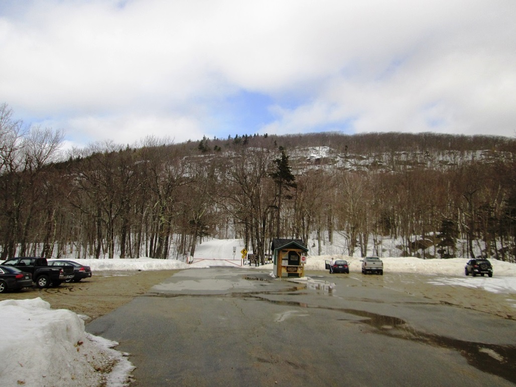
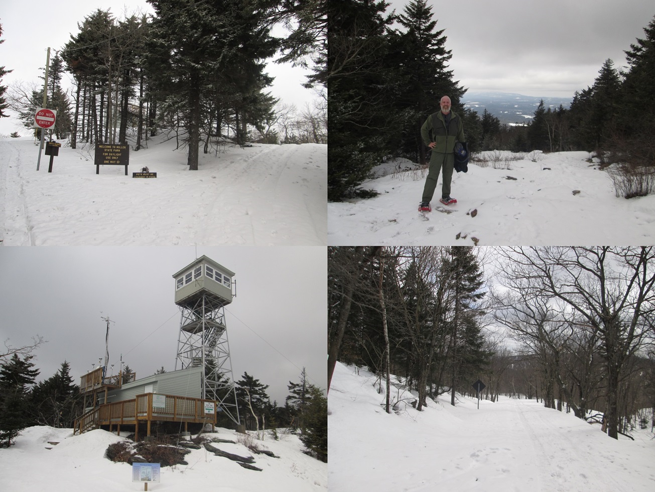
About noon, the snow lessened, then stopped. I decided to retry the hikes. I went back to the rental place, got the snowshoes again, and hit the road. To hedge my bets, I figured that of the two hikes I had planned, the one on Pack Monadnock Mountain would likelier be open. It's idiot-proof, even in snowy conditions, as there is a toll road that one can hike to the top. Under the circumstances, that was fine by me. So I re-routed my itinerary, and went north into New Hampshire first, Pack Monadnock Mountain on my agenda.
As I followed Interstate-495 and US-3 into Nashua NH, the skies even cleared to spotty blue sky, which was heartening. I followed the highways west out of Nashua, following NH-101 toward Peterborough. Pack Monadnock Mountain is immediately east of Peterborough, about 20 miles from Nashua, and about 45 or 50 from my hotel. The drive took about an hour, but in time I was going up the grades and soon found myself at the Miller State Park signs. The snow was piled high on both sides of the highway, but the parking area below the toll road was clear! And there were cars there. Awesome! Not only was it open, people had beaten in paths. I was very happy, because I had no idea of my chances of success, or even getting started, until I rolled in.
Pack Monadnock is part of a grouping of mountains all named "Monadnock" in southwest New Hampshire. The name is derived from the local Native American term for the mountains. The mountains all appear to be big rocky extrusions rising above the surrounding plains. The term "monadnock" has been generalized to refer to any mountain of a similar geology. Thus, the Monadnock mountains are all monadnocks, an interesting tautology. This particular Monadnock is smaller than the main "Mount" and the other "Grand" Monadnocks. But it's still a nice peak with over 1,200 feet of prominence. There are relatively few foothills coming in from the east or the west.
I get the impression that Pack Monadnock is a favorite "workout" peak for hikers living in the region. It has a few trails to the top, as well as the toll road. Some people hike it regularly for the exercise, perhaps so much so that they're bored with this peak by now. For me, this was exciting! My first New Hampshire peak ever, and my first county highpoint in nearly two years. And it was cold with snow. I'd actually have to earn this peak with some effort, too.
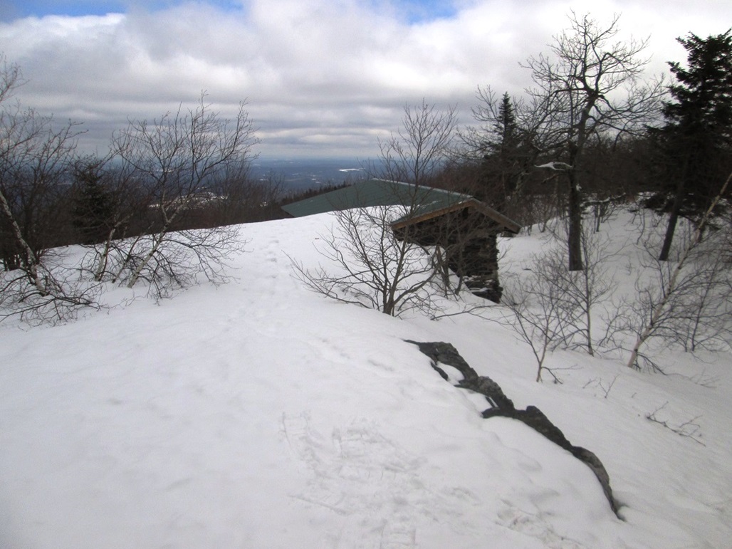
I paid my parking fee, got my stuff together, then walked onto the snow and put on my snowshoes. I talked to a couple young women who were emerging and they let me have their map, plus whatever knowledge they had. They had hiked it in hiking boots. The snow was so consolidated that it was possible to hike it in boots. But I was glad I had my snowshoes. They offered me a better margin for error. By 1:15 p.m., I was trudging up the toll road, making all sorts of crunching noises in my snowshoes.
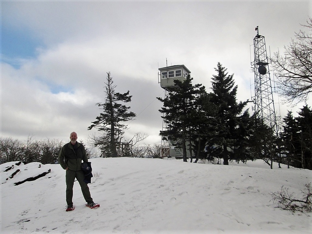
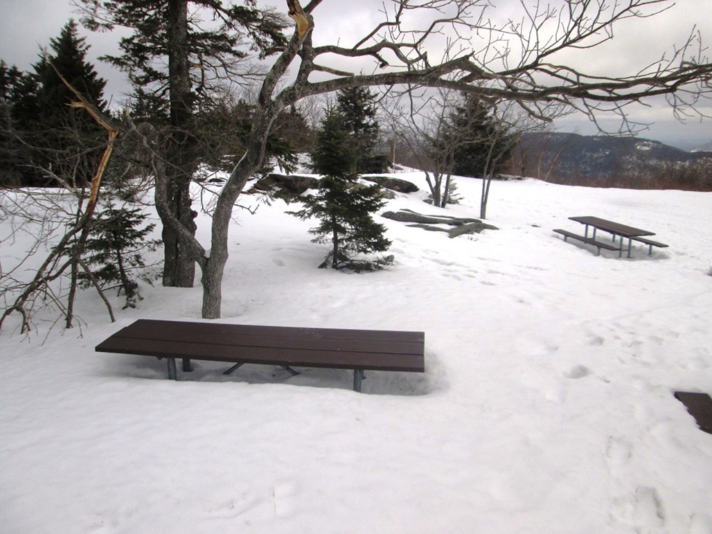
The route is a no-brainer. I followed the road as it turned a few times down low, then straightened out once it reached the main ridge. I met a couple hikers coming down, and we talked briefly. The hike was pleasant, the temperatures about 35 degrees F. I had brought along extra clothing, but I ended up carrying it instead of wearing it. As long as I kept moving, the cold did not affect me at all. In about 40 minutes, I had covered the 1.4 miles (says the map) to the top. The summit is broad with a few cell-phone towers, a lookout, some "comfort stations", picnic tables and a shelter. The snow was relatively deep, about 2 or 3 feet along the road, then about 3 or 4 feet up here, in swells, sometimes hiding the rocky landforms.
I met a gentleman who was sitting at one of the tables and we talked for about ten minutes. His stepson lives here in Tempe, Arizona! Small world. He was a very friendly person and very interesting too. He took a couple photos of me, so that I would have proof I was actually here, not drinking at some bar somewhere.
I spent about 20 minutes up top, tromping on anything that looked high. Some rocks stuck out from the snow, so I tagged them, plus I walked onto any swell that possibly covered the highest ground. The views were nice but hazy. Grand Monadnock rose to the west. Supposedly the buildings in Boston can be seen from up here, but not today. I chatted with the man once again before starting down. I followed the same route and descended in about 30 minutes. The snowshoes had worked wonderfully, and I was thrilled to have hiked this peak, especially since I had all but given up a few hours earlier.
It was a little before 3 p.m. when I started the drive out. I descended west down into Peterborough, which I found to be a very pretty city, with old-time buildings in its downtown, and very "New Englandy" homes lining the roads. I drove south on US-202 then followed NH-119 southeast toward my next objective, Watatic Mountain, which I had tried to visit earlier. Even after my success on Pack Monadnock Mountain, I wasn't sure I'd be so lucky on Mount Watatic, since the county highpoint is off trail a ways. The snow could cover important ground clues. There was only one way to find out, and I intended to try!
|


|