The Mountains of California
www.surgent.net |
| Frazier Mountain |
• Transverse Ranges • Los Padres National Forest • Ventura County |
|
Date: May 29, 2009
• Elevation: 8,013 feet
• Prominence: 2,453 feet
• Distance: 2 mile hike
• Time: 1 hour hike, 2 hours total
• Gain: 500 feet
• Conditions: Clear for now
California
•
Main
•
PB
Frazier Mountain is in northeast Ventura County, north of the town of Gorman and south of the famous Grapevine grade on Interstate-5. A dirt road leads to the top coming from the west side. Climbing this peak is simple and requires no skill nor even physical fitness since the road really does go to the top, not just somewhere nearby, and in good conditions, any passenger vehicle should be able to manage the dirt road. Apparently the peak is popular with hang gliders looking for a place to launch.
I first visited Frazier Mountain in 2007, but the big Day Fire of 2006 had scorched much of its slopes, as well as much of the nearby countryside, so the peak was closed to everyone while they cut down "problem" trees. For this trip, I had this peak planned, plus a couple more near Lake Isabella, northeast of Bakersfield. I had a two-week delay leaving Arizona for this trip: We had adopted five wonderful kittens to feed and care for until they could be adopted out. For the last two weeks I was the "kitty daddy", bottle feeding them and caring for them until they got old enough to eat on their own. Their adorableness was infinite. We kept two.
I left Arizona on the afternoon of the 28th, driving west to my brother's place in Cucamonga for an visit with his family, then crashing in Wrightwood for the night. The next morning, I left Wrightwood at 7 a.m., driving west toward Frazier Mountain through Palmdale and Lancaster along Routes CA-138 and CA-14. Other than infinitely many traffic lights getting through Palmdale, the drive went well.
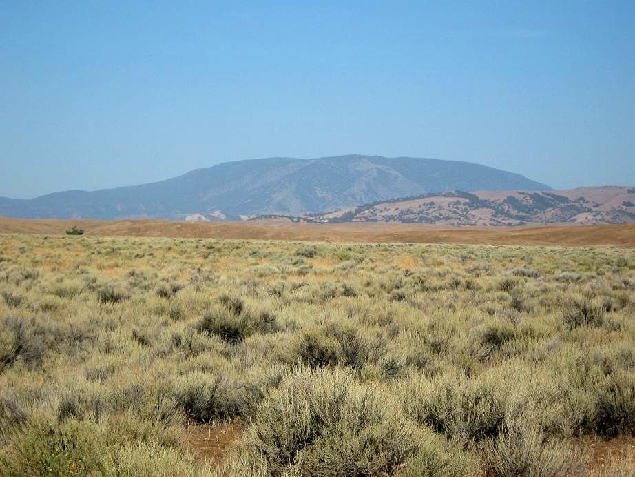
The nicest part of the drive was the long stretch of CA-138 west of Lancaster, all the while the mountains closing in on the high desert with Frazier Mountain's big bulk in the distance. On Interstate-5 briefly, I exited at Frazier Park Road, went west another 6 miles to Lockwood Valley Road, then left there another mile to the turnoff to Frazier Mountain Road. I stopped in at the Los Padres Forest Ranger Station here to ask about the road to the top, and the guy said everything is open, have fun.
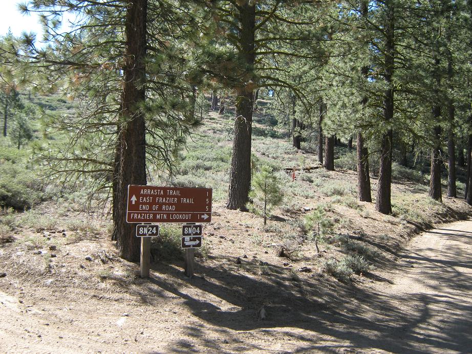
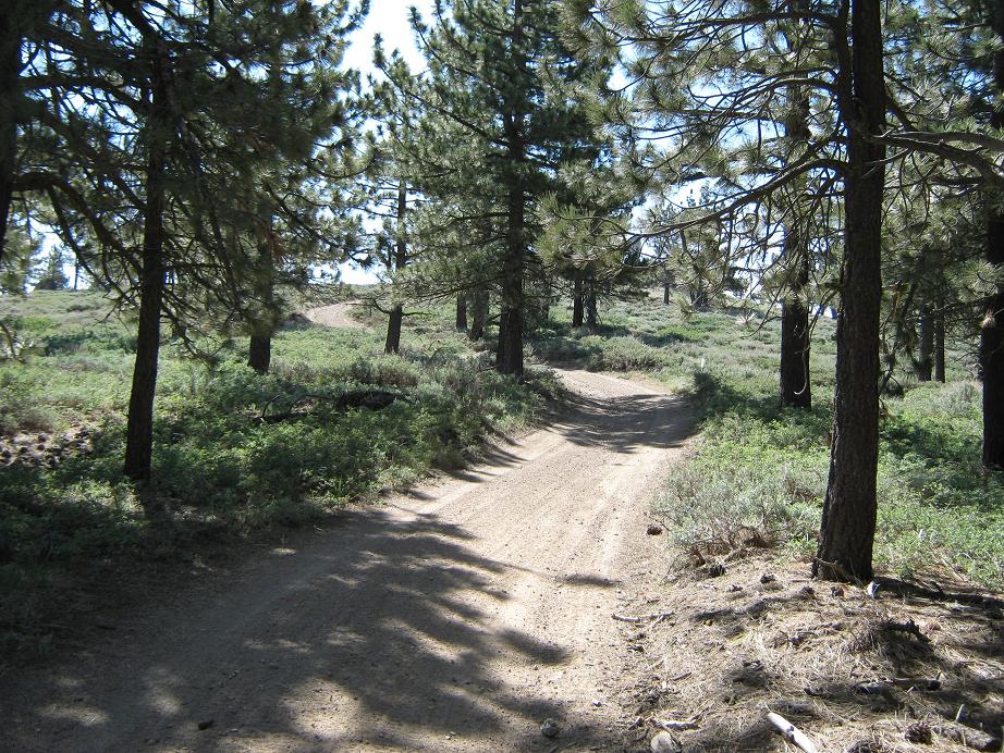
I drove up the paved continuation of Frazier Mountain Road (Forest Road 8-N-04), which narrows into a single lane for three miles to the Chuchupate Campground. Afterwards, a right fork continues to to the top. The road switchbacks up the west slopes through chaparral-covered hillsides, then enters into the pine forest. Another three miles (3.1, said my odometer), I came to the junctions with Forest Roads 8-N-04 and 8-N-24. These, along with another lesser road, form a loop to and from the summit. For those wishing to drive to the top, hang a right to stay on 8-N-04. I parked in a clearing and hiked the rest. The summit was just a mile distant, about 500 feet higher.
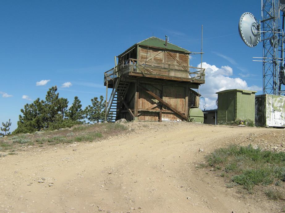
There is a well-beaten use trail up the slope between the two aforementioned forest roads. It led through sparse forest and brush-covered slopes toward rock outcrops, about a third of a mile of hiking and 250 feet of gain. At the rock outcrop there is a road, a dead-end spur not shown on the map. I followed the road up past one junction and then to another, which put me on 8-N-42, a lesser-quality forest road that forms the loop with roads 04 and 24. From here, I walked this road up to the top, leaving the forest for the final open stroll toward the communications equipment and old lookout tower. It had taken me 25 minutes.
The lookout tower is an old squat wooden structure, derelict and falling down ever so slowly. Even though it looked open to explore, I dared not trust the steps or the balcony. The views were fantastic, despite the hazy, moist air. Mount Pinos was visible to the northwest. I stayed on top 10 minutes, then walked back to my truck via 8-N-04, a round-trip hike of just less than an hour.
For grins I decided to drive back up to gauge the mileage and also check out the loop. I went up 8-N-04 to the lookout (1.2 miles according to my odometer), then down 8-N-42, which gets a little rough in spots. Road 8-N-42 goes for a mile where it meets with 8-N-24, which I followed back to the start of the loop, almost running into a couple ATVers. The total round trip: 3 miles exactly.
With Frazier Mountain now finished, I descended back to the Ranger Station, where I talked to the guy about Alamo Mountain to the south. That's when he told me it is still closed, but they hope to re-open it this summer. It just gives me an excuse to come back here again (which I did, in 2010).
I drove back to Interstate-5 and descended the Grapevine. As a kid we did this often as part of family vacations and I always enjoyed it, as the highway loses about 3,500 feet from Tejon Summit to the flatness of the San Joaquin Valley, all in about 10 miles. I think the last time I drove down the Grapevine was in 2000. The downhill part is fun. Going up, you have to battle slow trucks and your own engine's thermostat.
Once down, I exited the interstate and followed route CA-184 north through the exciting towns of Weedpatch and Lamont, arriving into Bakersfield on its east side, where I stopped for a Subway sandwich. It was only noon, and I had one more peak planned, Breckenridge Mountain. The clouds were building.
|


|