|
|
|
Date: January 18, 2009
• Elevation: 6,574 feet
• Prominence: 2,134 feet
• Distance: 4.4 miles
• Time: 5 hours
• Gain: 1,600 feet
• Conditions: Clear and warm
• Teammates: Scott Casterlin, Adam Helman, Rick Hartman, John Klein, John Hamann & Jack Bennett
Arizona
•
Main
•
AZ P1K
•
PB
Weaver Peak is in the foothills south of Prescott, near the communities of Peeples Valley and Yarnell. Highway US-89 runs through here, most well-known for the steep and exposed "Yarnell Grade" section, where the highway snakes up and down the steep south-facing cliffs that separate the high country to the north from the deserts to the south. This is a popular scenic back-way to Prescott from Phoenix, if one does not mind the curvy remaining 20 miles it takes to actually get into Prescott once past Yarnell and Peeples Valley. I drove it once when I had my motorcycle, and a few other times in my truck alone or with my wife. Going up or down the Yarnell grade never gets old.
The land here is extremely rocky. Whatever geology took place here left behind many hundreds (?) of square miles of rugged rocky peaks, spires and valleys, all covered in exposed granite boulders, some the size of a three-story building. The most visible example of these rocks is along sections of US-93 between Wickenburg and Wickieup, where the rocks come right up to the highway. It's all the same, pretty much the entire southern extent of the high plateau country. Between the rocks grows numerous cactus and dense brush. This region is mostly ranch country and contiguous state-owned property, and little development has ever taken place out here.
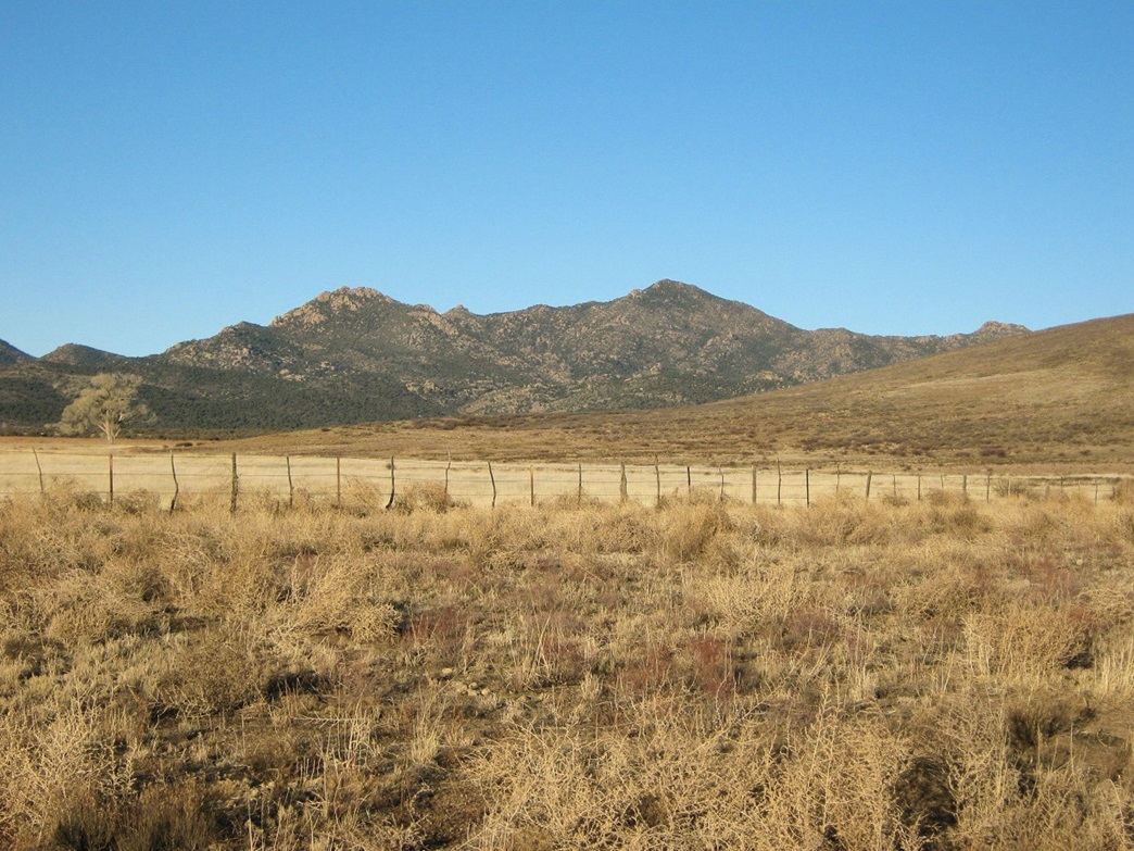
The Weaver Mountains run northwest to southeast, with Weaver Peak set back north and west of US-89. Weaver Peak is visible from the highway, a pointed, rocky, brush-covered peak about 6 miles distant. The slightly lower Rocky Boy Peak sits to the left of Weaver Peak as viewed from the highway. Both peaks lie on state lands, but surrounding these lands are some privately-owned lands, so getting close to Weaver Peak requires some advance homework to secure the permission of the landowner. Scott Casterlin was able to find out the landowner's name and sent him a letter requesting permission, and the landowner was kind enough to grant it. We chose the three-day Martin Luther King Jr. weekend as our hike date. Eventually seven of us would convene for the hike, including three from out of state.
I met Scott Casterlin in Scottsdale, then riding with him to north Phoenix where we picked up John Hamann. The three of us went west via the Carefree Highway (AZ-74) to Wickenburg, then to Congress where we picked up Adam Helman. Then we went up the Yarnell grade, through the town of Yarnell, and a little more north to the ranch road leading in to the rancher's property, where the other three guys were waiting for us: Rick Hartman, Jack Bennett and John Klein.
I've hiked with Scott, John H., Adam and Rick before; I met Jack and John K. for the first time today. Jack is famous as the first person to climb all thirteen Canadian Provincial and Territorial highpoints, which he completed in 1998 (his book, Not Won In A Day recounts his five-year epic). Apparently only one other person has duplicated Jack's feat since then, underscoring just how difficult it is to climb these peaks, some of which are located in the high Canadian Arctic or along the Alaskan boundary. John K. is a name familiar to me via the Southern Arizona Hiking Club as a trip-leader for numerous peaks, although I had yet to meet him prior to today.
After handshakes, we drove in to the rancher's place, met him, and spoke with him briefly. A real nice guy, he was perfectly happy to let us pass through his property to get close to Weaver Peak. He told us of the history of his ranch and gave us some ideas how to get close to the top. He has been to the top once before, and described some old paths that might get us close. No actual path exists to the summit, though. He got on his quad, joined by his dog, and led us along an old Jeep route for a couple miles into the mountains.
One section of road was very rocky and troublesome, but the three vehicles got up and past it on the way in (we wouldn't be so lucky on the way out, though). We all parked near a stock tank, about two miles east of the summit. In places we were following tracks that were barely discernible in the low grass and brush. Obviously, it would have been very difficult to get here without the rancher's knowledge of the roads. After some more chatting and getting our stuff ready, we started the hike at 9:30 a.m., elevation about 5,020 feet, in clear, pleasantly warm conditions.
The rancher suggested we follow a fence line (shown on the map) that runs northwest from the stock tank. A well-beaten cow-path runs parallel to this fence, and as we followed it we saw horseshoe prints, cow hoof prints and plenty of cow poop. The trail doesn't gain much elevation during this stretch, which was maybe no more than half a mile of actual travel, but at least it put us closer to the peak. Within thirty minutes we'd come to the end of this path, and now we began the cross-country portion of the climb.
I'd like to say that we followed a nice route that was mostly open where most brush could be avoided, but unfortunately, this was not the case. None of us had ever been here before and no useful information on the web or otherwise gave us any insights. We just followed what seemed logical and hoped it worked. The initial few hundred vertical feet of bushwhacking went reasonably well, all things considered. Most of the time there was an open route between the worst of the brush, and the rocks themselves had plenty of easy options to bypass or clamber over. We took our first break after 50 minutes, per Adam's timekeeping. Someone mentioned we had covered 1.4 miles from the cars and had gained about 700 feet, leaving roughly 900 to go. So far, not too bad.
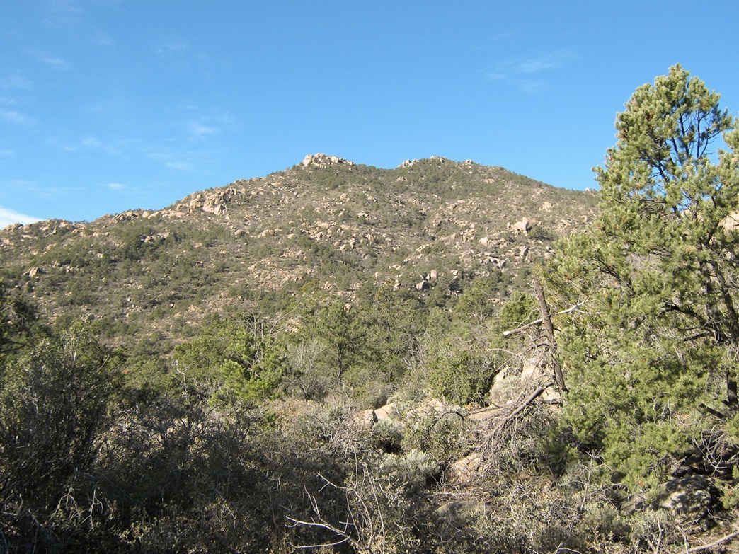
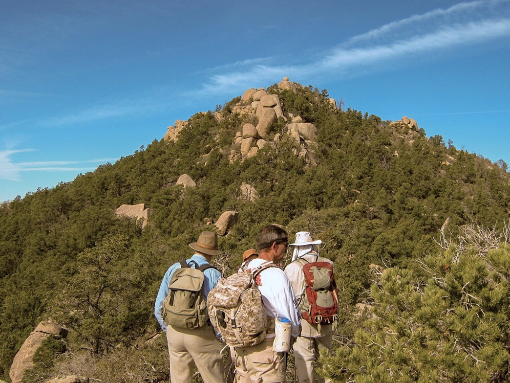
We had settled on a route that aimed for the main southeastern ridge of the peak. A prominent rock pinnacle sits on this ridge, shown on the map as a single small 6,400-foot contour to the southeast of the summit. In the first photo at left, this pinnacle is visible as a small knob of rock immediately to the left of the summit, and in the second photo it is a little more detailed. Both the map and the photo would suggest this rocky pinnacle to be nothing much, but in reality it was a fairly challenging obstacle, and getting past it would prove to be the crux of the climb.
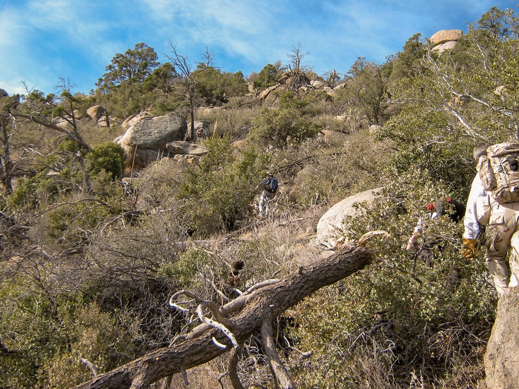
Just getting to this pinnacle from our first rest stop would also be a struggle too, as by now the brush had really closed in, and generally no real way up existed that didn't involve direct plowing through the brush. We strung out in places, sometimes groups of two or three trying an alternative path and generally no one having any better luck than anyone else, but we did manage to move upward, albeit slowly and tediously.
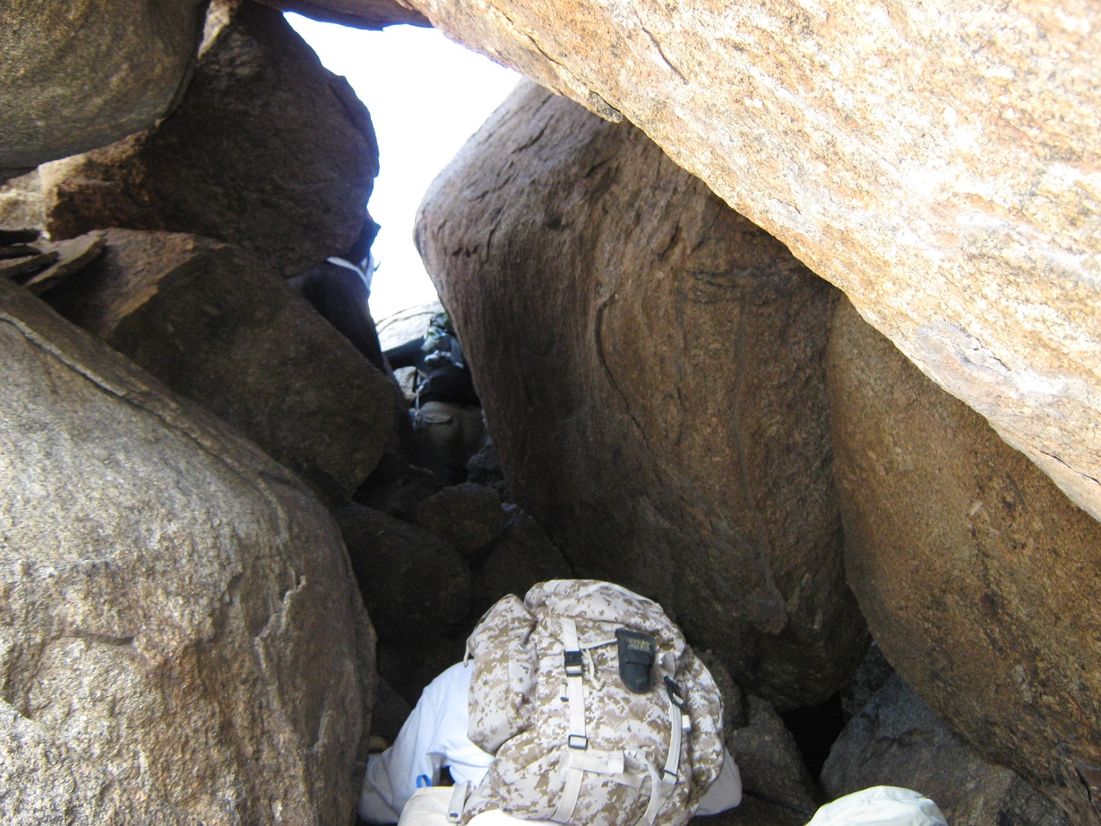
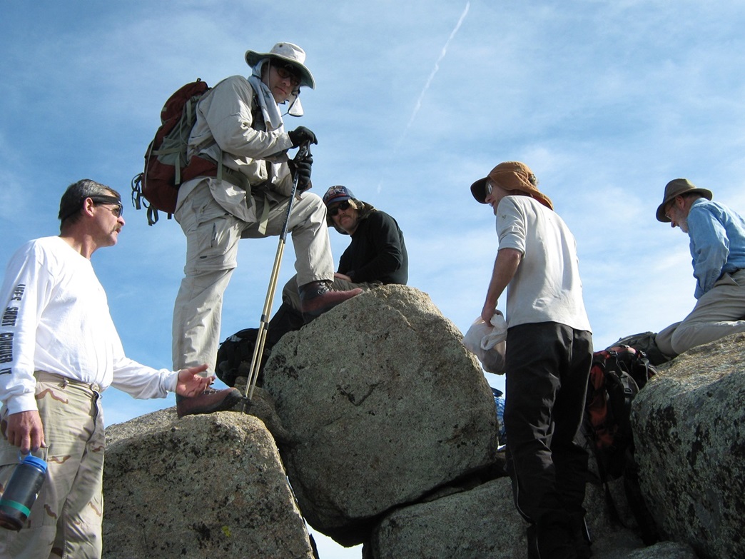
In time we had all convened at the base of this pinnacle. The guys at the front had already started poking around for ways through it, and the only workable route involved hiking through a natural tunnel, a void created by these giant rocks leaning against one another. In the heart of this void, we scampered up a sloping rock standing seven feet high, but requiring some awkward positioning to actually get up the damn thing. Maybe it was me being bigger than most, but my back kept banging into the other rock behind me, too close to use as a chimney. Instead I put both hands into a crack and leaned against the rock I wanted to ascend. It wasn't pretty, but I got up it.
After a few more feet of somewhat exposed rock to bypass, we were now mostly through this pinnacle. The last move was to hop onto and across a few big slabby boulders, the only tricky portion being the mental aspect of ignoring the big drop below if one of the hops didn't land right. We got past those too, and all reconvened now on the summit-side of this pinnacle. This part had been real nasty and I had no desire to come back down this way. I was heartened when others expressed the same sentiment. The good news: the summit was in view, just a quarter-mile away and about 150 feet higher.
The final portion of the hike took us across thick brush and easy terrain, approaching the summit from its southeast before angling left, reaching the top by circling and coming to it from the west. The rock here was not too bad, but the brush was relentlessly thick. We made the summit at about noon, a two-and-a-half hour ascent time. The summit is (surprise) composed of big slabby granite boulders lying in a heap, but fortunately, attaining the highest rock was not complicated at all. A USGS benchmark is cemented into this highest rock. Everyone sat on or near the summit and we all enjoyed lunch and some home-made fudge, courtesy Adam. Getting this summit was especially sweet considering what we battled through to get here. Despite long sleeves and pants, I was scratched up pretty good, and my pants had a huge hole in the knee, torn by brush earlier on.
On the summit, we signed into the log, noting that the previous entries were from 2003, a six-year lag between ascents. I figured maybe someone or two would have been up here since then but after the brushy scramble we just went through, perhaps this is accurate. We took photos and played "identify the surrounding mountains". We had clear skies and dry conditions so we could see peaks all the way up past Flagstaff. From where I sat I had a great view of big Harquahala Peak to the west. Signal Peak in Yuma County was barely visible farther on. I was content to sit on a nice open rock a few feet below the top, and relax. We stayed up top for about 30 minutes, by my estimate.
For the descent we came off the peak directly opposite the way we had come up, by heading generally slightly southeast of east, deliberately to avoid the ridge we came up, and for awhile this descent route worked very well, and I daresay there was evidence of a path in places, but maybe that was my brain hoping there was actually one that would take us all the way out. We dropped about 500 feet pretty quickly, but equally as quickly the ridges started to become more defined and we found ourselves descending into a drainage, with very heavy brush and jumbles of rocks. We followed this drainage for awhile, and when it felt right followed some routes up out of the drainage, all done by instinct. Fortunately the worst of the obstacles we faced on the descent was just very thick brush and some occasionally awkward moves down from one rock to another. Snakes were on my mind but also bees, as I saw a few buzzing me here and there.
Slowly, the slopes began to moderate and the brush seemed to let up. The first positive sign I saw that the worst of the rocks and brush was over was a big pile of cow poop, suggesting that if those big lumbering meats can get up this far, there must be an easy way down. We aimed east, trying to re-meet the fence line, walking up and down many smaller easier humps and dips. Then we spotted fence posts and barbed wire ... the fence! We even saw our own boot prints, facing the other way, in the sandy trail. In fact, we had actually come to the fence much closer to the vehicles than expected. Within minutes we rounded a bend and there the cars were, the prettiest sight of the day. Casterlin had the time as 2:30 p.m., a five-hour hike. I think we were all glad to be back to the cars and out of that brushy nightmare. Having the summit done made it worth it. We got things packed and started the drive out. Then things got real interesting.
The portion of the road that had given us trouble coming up proved to be equally troublesome going out: Casterlin high-centered his Blazer on a set of rocks. We all got out, looked at the situation, tried a few things, but in the end he had to jack his Blazer up, dig a hole and shove a lot of rocks into the hole for traction, which worked, a total delay of 20 minutes. A few minutes later we were back on to the highway.
For a final capper to an interesting day, we came upon a big tractor and trailer truck on its side on the first bend of the downhill portion of the Yarnell grade. Looked like he took it fast, skidded, and gravity took care of the rest. The firemen and cops were all there, setting up cones and directing traffic around the site. The cab of the tractor looked intact so we hope the driver was okay. We drove down the grade into Congress, dropped Adam off and bid goodbye to everyone (Rick, Jack and Adam were heading west for another peak the next morning). Casterlin, John H. and I continued back into Phoenix, catching the last fifteen seconds of the NFC championship game on the radio, which our local Cardinals won, a 32-25 verdict over the Eagles. This win put the Cards into the Super Bowl, believe it or not.
The three of us had burgers at a Denny's on the Carefree Highway, dropped John off, then the two of us drove back to Casterlin's place so I could get my truck and head home. By now it was dark, but only about 7 p.m. I was my usual tried and beat-up self, but happy to be home and happy to have Weaver done and in the books, and especially happy to never have to deal with that terrain ever again.
Closing comments:
The brush was a mix of manzanita, mountain oak, madrone, grasses of all sorts, prickly-pear cactus (I got its fine hair-like spines on me in three places and spent the next couple of days pulling them out off my skin), agave, and larger trees like pine (limber maybe?). Curiously, there was not any cholla or ocotillo. The brush here seemed more like the kind one would find on the coastal ranges in Southern California. It was by far the most grueling brush I have dealt with on an Arizona peak. The upside was that given all the brush, the actual hike was not lengthy at all, and our gain not tremendous either. I don't think I could have mentally coped with another thousand feet of this brush. It was brutal.
The rancher was super friendly, and he didn't seem to mind us crossing his property to get to the peak, but he obviously appreciated the advance request. He mentioned he's had trouble in the past with the occasional yahoo, and ironically, Christmas-tree cutters. I am not printing his name, however, out of deference to his privacy.
The team was strong and I thank each and every one of them for being good partners on the climb, everyone helping one another out in places.
|