The Mountains of Arizona
• www.surgent.net
|
| Mount Union |
• Highpoint: Bradshaw Mountains • Prescott National Forest • Highpoint: Yavapai County |
|
Dates: (1) October 9, 1999; (2) January 11, 2003; (3) September 12, 2008
• Elevation: 7,979 feet
• Prominence: 2,939 feet
• Distance: 1 mile
• Time: 1 hour
• Gain: 380 feet
• Conditions: Cool in 1999, cold and frosty in 2003, humid and stormy in 2008
• Teammates: Just me in 1999; Dan B., Scott C., Ken R. and others (Highpointers Convention outing) in 2008
Arizona
•
Main
•
AZ P1K
•
PB • LoJ
Mount Union is the highest point of the Bradshaw Mountains near Prescott. The Bradshaw Mountains are significant in Arizona's history, for it was one of the first places to be settled by American settlers in the 1840s and 1850s. The town of Prescott grew quickly and became the territory's first important big city. Today the sprawling range is an easy reach from Prescott, but much of the range is still undeveloped, and although lots of roads cross the range, a lot of it is surprisingly remote and difficult to access, giving the place an aura of timelessness and solitude.
Numerous ghost towns and townsites can be found in the Bradshaws. Some are just sites, nothing to see, while others are still functioning. Crown King is the best known of the old towns, while Cleator is a fascinating relic, still populated and a real time-warp of a place. Seeking the Yavapai County highpoint is fairly simple, as it's close to Prescott. When I journeyed here in October 1999, I was just a brand-new county highpointer, not entirely sure if this hobby was really what I wanted to be doing.
First Visit, October 1999: I decided on a whim to get out of Phoenix for a day and head up to the Prescott National Forest and the Bradshaw Mountains for some backroads exploration in my truck. Fall had arrived in a hurry and the day was breezy and brisk, but beautifully clear. I left home around 8:30 a.m. and went north on Interstate-17 to Cordes Junction. Then, west on AZ-89 for about 30 miles, or most of the way toward Prescott.
From the highway, I turned south onto Walker Road, which is a paved route leading into the Bradshaws, passing lakes and campgrounds along the way. After a while, the pavement ended and the road turned to dirt. I followed the signs to Walker townsite and then to Potato Patch, merging onto the Senator Highway, which is a dirt backcountry byway that starts in Prescott and heads south as far as Crown King. The Senator Highway was better graded than Walker Road, and I followed this for about 2 miles until I came to the Mount Union junction.
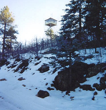
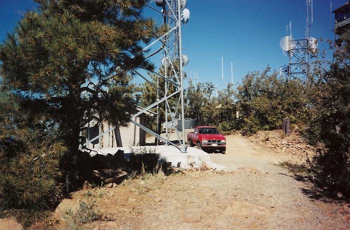
The last mile along this road spur was rough, so I put my truck into 4-wheel drive and rumbled my way to the very top of Mount Union, arriving around 11 a.m. It was breezy and cool, about 45 degrees. The top is flat and features a couple of small buildings, a lookout and power lines. After a few minutes, I turned around and headed out. I followed the Senator Highway all the way into Prescott, where it turns into Mount Vernon Road and meets up with AZ-89 (Gurley Rd) east of the historic downtown. I spent a couple of hours in town, having lunch at the Palace hotel, and walking around the downtown area. The weather was gorgeous, and a number of bikers were in town as well (When I had my motorcycle, I made a trip to Prescott, too). I returned home via Yarnell, Congress, Wickenburg and the Sun Cities.
Comments on the routes: Four wheel drive is not necessary on the approach roads, but it's nice to have on the Mount Union spur road. A high clearance vehicle would normally make that spur fine. A low clearance passenger car would probably not. At worst, that would create about a mile round-trip hike should you need to park early. The Groom Creek map is vital just to negotiate the roads, which go every-which-way and have spurs, turnoffs and loops. Also, the road is gated just below the top. I was fortunate to be able to drive it when I did.
Second visit, January 2003: For this journey, we took the long scenic route, south from Crown King along the old Senator Highway route. We left home about 9:30 a.m. and exited Interstate-17 at Bumble Bee/Crown King Road. The first town we came to was Bumble Bee, 5 miles from the interstate. Bumble Bee today conists of a cafe and gift shop, and about 5 or 6 bungalows built in the 1930s. Most of the original buildings from the early 1900s having been burnt down or carted off. We stopped in the cafe and chatted with a man named Virgil, representing half of Bumble Bee's full-time population. A few other folks live there seasonally, and there's a large ranch about a half-mile south.
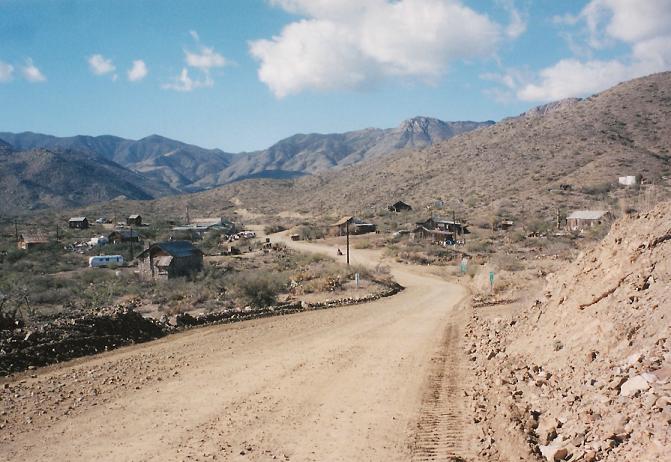
Nine miles up the road, we arrived in Cleator, appearing suddenly as we crested the road. Unlike Bumble Bee, most of the buildings in Cleator are original and laid out haphazardly, more typical of these towns from the olden days. The town has about a dozen full-time residents and a bar. We saw a few trucks, and the whole place looked fascinating and authentic. Apparently, we missed "Cleator Day", which had a parade and chili cook-off.
Continuing out of Cleator, we followed the Crown King Road south. The road itself is the old railroad bed of "Murphy's Impossible Railroad", which was built to haul ore out of Crown King's mines. To put it in, long stretches had to be blasted into the rock, and to account for the low grades required by railroad cars, long switchbacks snake up the mountainsides at lenient grades by automobile standards.
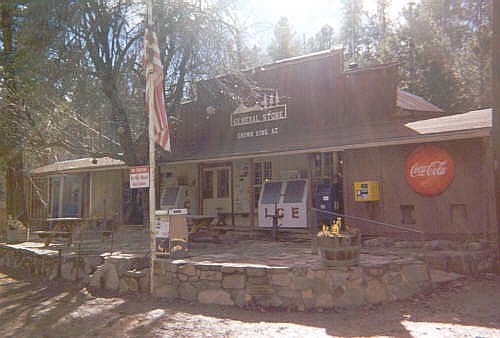
Twelve miles south of Cleator and almost 26 miles since the interstate, we arrived into Crown King, 6,000 feet in elevation amid tall pines. Including our stops, this drive took a little over an hour. We stopped in at the general store and toured Main Street, featuring a restaurant, a saloon, a church and a Forest Service fire station. About 100 people live in Crown King full time. There are some mines still working in the area, but most people live there for the remote solitude and cool weather. About another 300 people live there seasonally, and weekend crowds from Phoenix are common, especially in summer. The road is well-graded and passable by passenger vehicle, except in the worst of weather.
After about a half-hour, we set out again. Most people who drive to Crown King apparently leave the way they came in. Our intent, instead, was to drive the Senator Highway to Prescott. Leaving Crown King, we drove a couple miles to the townsite of Bradshaw City, which has no significant remains today, for a picnic lunch. During our time there, we saw one Jeep and about four or five quadrunners pass us. The road is no longer an old railroad bed, but now a more typical forest road: narrow, steep, occasionally rutted and rocky. The sign said 38 miles to Prescott, and the guidebook said to allow three hours.
The Senator Highway is today just a long, interesting forest road (FR-52). In its hey-day, it was a stage-coach route from Prescott to Crown King and Phoenix, back when Prescott was the territorial capital and Phoenix was a hot, lonely outpost in the desert. Traveling this road isn't difficult. The signs and guidebooks insist that a high-clearance vehicle is mandatory, but for most of the 38 miles into Prescott, the road is reasonably level and reasonably smooth. However, there are areas of ruts, rocks and steep grades, plus some creek crossings. I did not need 4-wheel drive. Periodically we'd come to an unsigned junction, always staying straight and following what appeared to be the road most traveled. (Update, 2011: the roads are noticeably worse, requiring hefty 4-wheel drive at a minimum).
There were moments when I wondered if I'd made a bad decision, but then a sign later on down the road would reassure me I had not. Traveling was slow. Even on the occasional smooth straight stretch, I'd be lucky to get up to 15 mph. We were happy to take it slow and take in the sights. We made one stop to hike up an unnamed hill for some views, including that of Mount Union, still way off to the north.
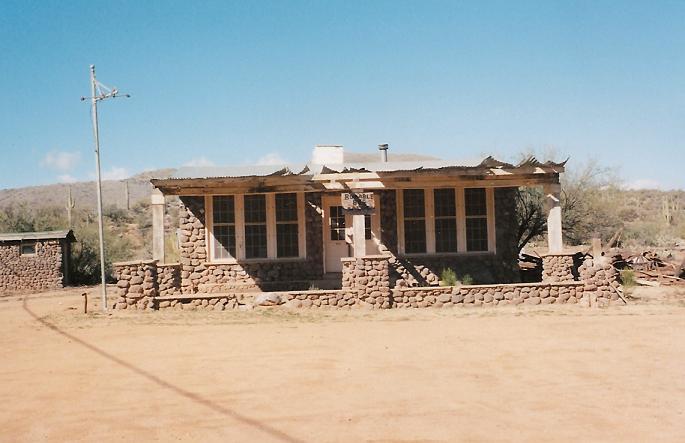
After nearly 2 hours on this road, in which time we had covered no more than 25 miles, we came upon Palace Station, which was a stage stop along the Senator Highway, and today consists of one preserved building and some interpretive signs and walking areas. Just north of this spot was a hand-made sign mentioning "Snow, 4wd" in orange spray paint upon a wooden palette. A few days earlier a storm had moved through Arizona and though most of the snow had melted and we had seen very little of it on our drive in, we were coming upon some areas shaded from the sun where snow might still be in place. Well, there was. I used 4-wheel drive, but previous vehicles had already worn paths through the standing snow. My concern was ice, as the sun was now mostly low in the sky and the temperatures getting quite cold.
In any case, we finally came upon the Mount Union Road junction and drove as far up as we could before coming to a locked gate about a half-mile from the summit. There was still a lot of snow on this short stretch of road, and it was obvious very few people had driven this in the previous days. We parked and hiked in, achieving the summit after about 20 minutes in cold, brisk but beautiful and clear weather. After some photos at the summit, we headed back down and drove the remaining road out to Prescott, arriving as darkness fell. We ate at the St. Michael's Hotel Restaurant on Whiskey Row. After a night at a Super-8, we headed back to Phoenix.
To attain Mount Union from the south via our route we had driven 54 miles of dirt road, the first 26 via the Bumble Bee-Crown King Road, and the next 28 via the much narrower Senator Highway. Including stops it had taken us nearly five hours to get to the base of Mount Union. Total, we drove nearly 61 miles on dirt before pavement just outside of Prescott. The road to Crown King from Interstate-17 is interesting and I'd do it again any time. However, I think the drive along the Senator Highway is a once-in-a-lifetime thing for me, although I wouldn't mind going back to that area and exploring some other side roads.
Third Visit, September 2008: I came back for another whirl with Union as part of the National Highpointers 2008 convention being held in Flagstaff. I was to lead this little excursion for the benefit of the visitors. I did not actually attend the convention, but instead drove up from Chandler that morning and met everyone at the Walker Road intersection with Highway AZ-69, following the same route I went back in 1999.
We met at 10 sharp, a total of five visitors and me. Dan B., Scott C. and Ken R. came in one car, and two brothers whose names escape me at this moment in another; we convoyed in three vehicles to the highpoint following the roads through Walker and Potato Patch to the Senator Highway, then from there up FR-261 to the gate. The walk up went quickly amid some threatening thunderheads. We took our photos and stuck around a few minutes, the entire hike covering an hour.
Back down, we went out the Senator Highway into Prescott, where we all split ways. I went home via the neat AZ-89 drop down the Weaver Mountains into Congress and via Wickenburg. It was a fun day trip, and neat to revisit this highpoint after 5 years.
|

|