
The Mountains of Arizona
• www.surgent.net
|
| Peak 2582 |
• Ajo Mountains • Organ Pipe Cactus National Monument • Pima County |
|
Date: February 4, 2022
• Elevation: 2,582 feet
• Prominence: 320 feet (per Lidar)
• Distance: 1.5 miles
• Time: 1 hour
• Gain: 402 feet
• Conditions: Clear, but the wind, oh my
Arizona
•
Main
•
PB
•
LoJ
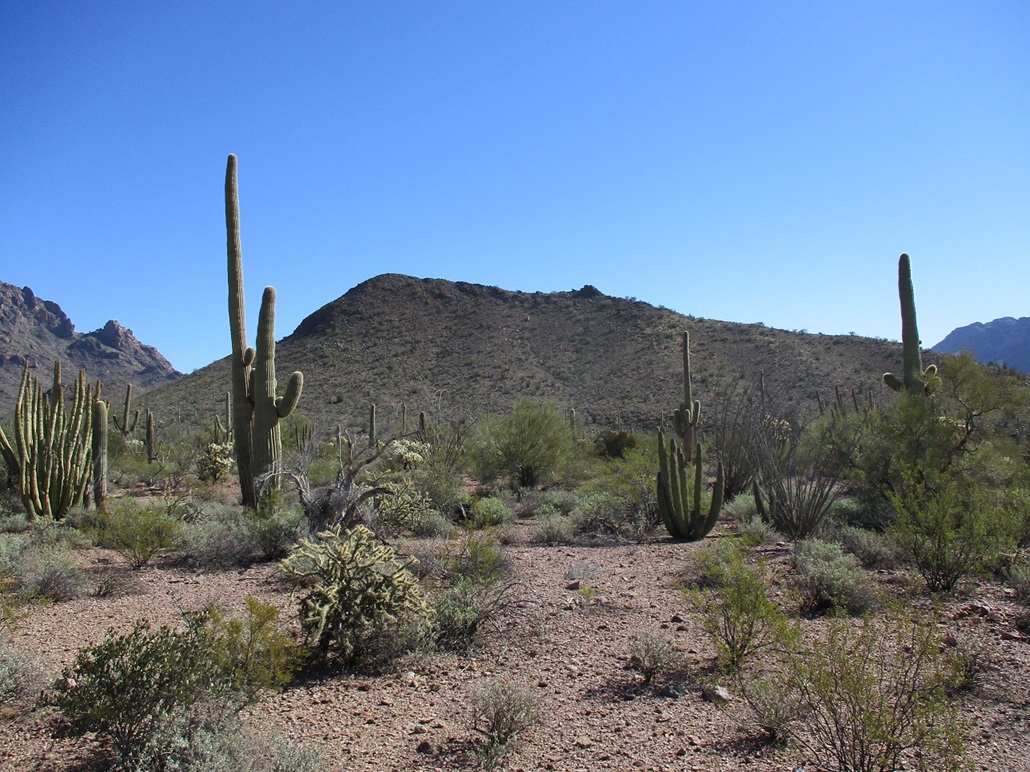
Peak 2582 is a completely uninteresting and anonymous peak close by the Ajo Mountain Scenic Loop Drive in the Organ Pipe Cactus National Monument. When I woke up this morning, I had no intention to climb this peak, and wasn't even aware it existed. Long story short, things went to hell, and I ended up climbing this little guy simply to justify all the time and energy I spent getting here.
My plan was much more grand in scope. I wanted to hike the highpoints of both Tillotson Mountain and Diablo Mountain. Both lie close to the Loop Road, and I thought I could get them both done in a day. I hiked Mount Ajo way back in 2006. This would be my first time back on the loop road since then.
I left Tempe before dawn, stopped briefly in Gila Bend for snacks and sodas, continued south on AZ-85 into Ajo, the sun starting to come up about now. I continued south beyond Ajo through Why and onto the Organ Pipe Cactus National Monument, and finally onto the Loop Road. So far, everything was dandy.
On the Loop Drive now, I noticed how windy it was. I had not noticed it on my drive down, and in Gila Bend, it was calm. But here, it was blowing hard, kicking up dust and causing my car to shake if the wind hit it broadside. I drove to a bend in the road that is east of Tillotson Peak, the time now about 8 a.m.
The wind was heavy and fast. It shook the car steadily. Big 30-foot saguaro teetered in the wind. The lower brush such as the palo verde and creosote were flailing furiously. And it was cold, about 40°. I got out of the car to fetch some items from the back and got knocked back by the combined effect of the wind and cold. To say it was uncomfortable is like saying the Pacific Ocean is wet.
Maybe this was just a morning thing, maybe some localized katabatics that will go away once things warm. So I got back into the front and just sat there. I even tried taking a little nap. No luck. It was now 9 a.m. and the wind was as strong as ever. I wanted no part of the wind for this hike. It looked especially dicey way up top on the highest crest. I wanted to have fun, not shake and shiver in the cold gales. So I called it. I never got out of the car except to grab a couple things.
I then drove a few more miles to the parking and picnic area for the Bull Pasture Trailhead, the one that leads to Mount Ajo. There were about ten cars parked here. The guy next to me was trying to cook something using his hatchback and rear storage area as a windbreak. We chatted for a few minutes. I assume everyone else was braving the wind and heading up to Bull Pasture, maybe a few going for Mount Ajo too. Me, I was going the other way, up toward Diable Mountain Highpoint.
Here, I was shielded somewhat from the wind so that it was just a strong breeze. I hiked uphill to catch a saddle and a ridge about 100 feet higher, then turned left, aiming south for the summit, still a mile-plus away and invisible for now. I got up a couple weak cliff bands and everything seemed to be going well. But then I got higher on the ridge and wham, the wind just slammed me again. I was in its wheelhouse, me a mere speck compared to its power. I called it again. It was just too freaking uncomfortable in it, not to mention the potential for injury if I was higher and more exposed. So back to my car, me.
By now, I was feeling a little aggravated. I had no regrets about turning back on both hikes. I never feel regret because I know it's always the right decision at the time. But I still felt bummed about having driven about 170 miles with no peaks to show for it. Which brings us to this peak.
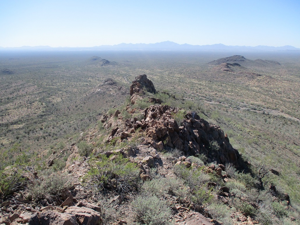
I drove some more on the Loop Road and positioned myself south of Diablo Mountain and north of a cleaver-shaped hill about a half-mile south of the road. I looked it up on my phone and by gum, it is a ranked peak, just barely. It had a long and consistent slope and looked easy, wind notwithstanding. So I decided to hike this peak. Heck, it would at least be something.
I hiked south into the desert brush, down and up a couple arroyos, and quickly, I was at the base of a slope that went up and met the main crest not too much farther away. I was up this hill and on the crest quickly. And now exposed, the wind was blasting me once again.
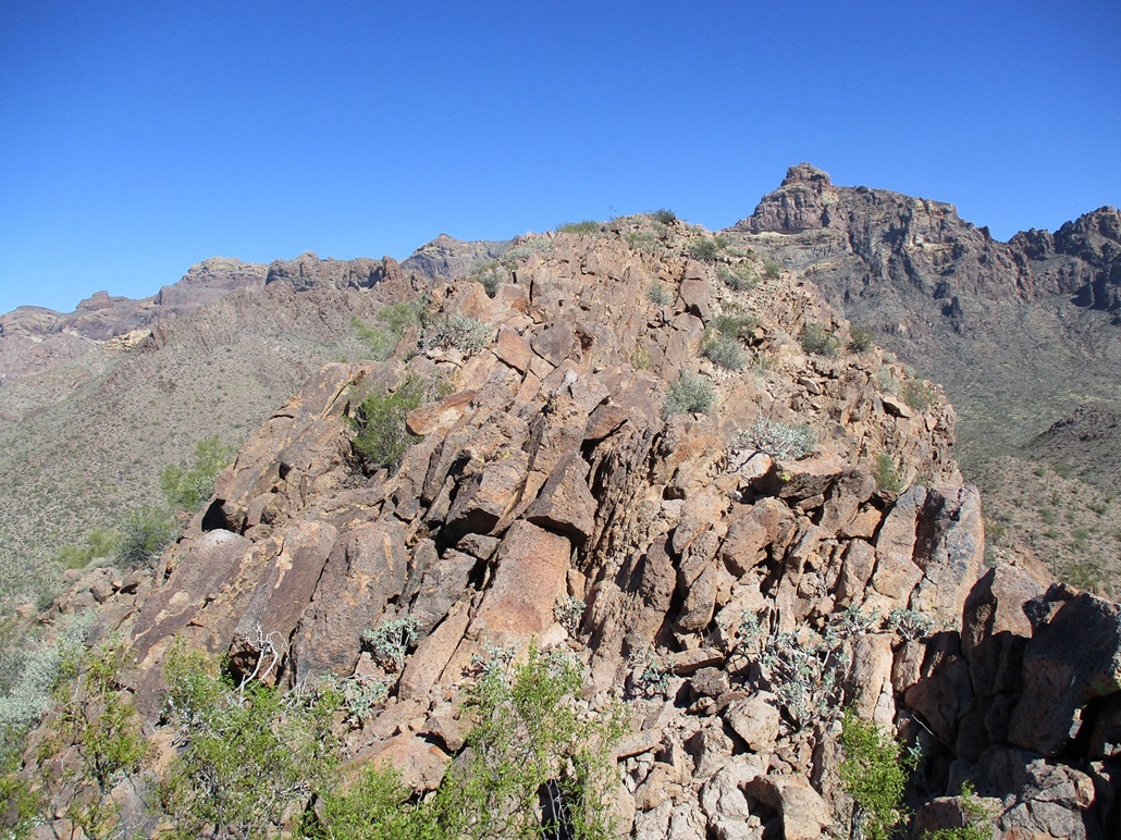
Higher up is a large rock pinnacle, which was visible from below, a classic ridge-line gendarme. I used the hope method of climbing, which is I hope there's a way past it. Once upon it, I saw a sloppy but viable ledge-path on climber's left. I followed it and was was soon past the pinnacle. The summit wasn't much farther, maybe 300 feet.
I clambered past a few rock piles then came to a knife edge. I don't like them on a good day, but in the wind, things could be troublesome. I may have yelled a cuss word or two. No damn way I was going to go 0 for 3 today. So I carefully inched my way past this knife edge, which turned out to be only about 15 feet in length. Past it, the summit was another three-minute walk up the rocky slope.
The wind was strong and unrelenting. It wasn't like a gust here and there. It was a steady 40-50 mile per hour gale. If I stood up, it would push me aside. I had little room for error here, so I did a football-player crouch, one hand always on the rock in case I needed to sit down real fast. I got to the summit, took an image, looked around and started right back down. I carefully moved through the narrow portions and down past the big rock pinnacle. Only when I was below the crest did I get some mitigation from the wind.
The hike out went fast and I was gone about 45 minutes. This was a lame peak, but it counts, and I was grateful for that. I exited the Loop Road and drove to the Organ Pipe Cactus Visitor's Center to look at things and relax a little bit. I had a weak plan to inspect a hill near Pinkley Peak that I could possibly add on. Given how things had transpired this morning, I wasn't picky at all, and knew no shame. Any bump, hillock or convexity would be fine with me right about now.
The Visitor's Center had a table set up with the usual things a visitor would want, e.g. maps, brochures and so forth. It keeps the number of people who go inside to a minimum and thereby keeps everyone socially distant. The woman who was at the table was positively stunning, even with a mask on. Tall with a killer figure, longish hair and beautiful eyes. And this was while wearing those National Park uniforms. Suddenly, all the angst and drama I had experienced this morning went away. I appreciate that the National Park Service is hiring from under-represented groups such as the gorgeous honeys. We need more diversity that way.
That hill by Pinkley Peak wasn't as easy to get to as I hoped, but really, I didn't care. I got a weenie peak climbed and figured that was a good deal given the conditions. I had originally reserved a room in Ajo for the night but decided to bail altogether. I wanted to position myself for some explorations along Agua Caliente Road, so I made a reservation in Gila Bend. It was only 2 p.m. so I drove north to Interstate-8, and with time to kill, drove east about 25 miles to the Freeman Road exit and hiked Lost Horse Peak. It wasn't much of a peak either but it would at least make me feel like I had a productive day.
|


|