The Mountains of Arizona
• www.surgent.net
|
| Mount Lemmon |
• Highpoint: Santa Catalina Mountains • Coronado National Forest • Highpoint: Pima County |
. . . . . . .
Summit Panoramas
Computer generated panoramas from the summit, as created by Jonathan de Ferranti, a map-wizard based in
Scotland. His highly-detailed images describe the distant horizons, ranges and peaks, with compass bearings and distances provided. They are remarkable and, in my opinion, beautiful works of art. Please check them out!
|
Dates: (1) July 7, 1997; (2) August 28, 2004; (3) June 13, 2010
• Elevation: 9,157 feet
• Prominence: 5,157 feet
• Distance: 1 to 6 miles
• Time: 2 hours in 1997 and 2004, 5 hours in 2010
• Gain: 800 feet in 2004, 2,200 feet in 2010
• Conditions: Hot in 1997, Hot in 2004, Nice in 2010
Arizona
•
Main
•
AZ P1K
•
PB • LoJ
Mount Lemmon is the highest point of the Santa Catalina Range, north of Tucson. The giant range rises nearly 7,000 vertical feet above Tucson and is one of just five mountains in Arizona with over 5,000 vertical feet of prominence. The Santa Catalinas are a hiker's paradise, but ironically, Mount Lemmon's summit is a dud. It was graded flat years ago, houses an observatory complex, and a road gets within feet of the highest point. It presents virtually no challenges.
Despite this, a visit to Mount Lemmon is worth the trouble. The scenic Catalina Highway snakes 27 miles from Tucson below, to a small ski area just short of the top. Along the way are numerous pullouts and options to hike, camp and explore. In summer, these highlands are very pleasant, compared to the hot deserts below. I have been to the top three times, in 1997, again in 2004, and a third time in 2010.
First Visit, July 1997: I got an early start from home and drove to Tucson and up the Catalina Highway, my primary goal to hike out to Rice Peak via the Arizona Trail. I was vaguely aware of the Pinal County highpoint being out there and wanted to visit it. I started hiking about 9 a.m. in warm conditions. I descended a thousand vertical feet to Dan Saddle and was alarmed at the rising heat. I hiked another mile or two to within sight of Rice Peak, but then I took a bad spill on the trail. It's rare for me to fall... but I did, and kind of bad, too.
I was concerned about my water. I had brought too little, and had hiked nearly four miles from my car. I still had two more miles to Rice Peak and the day was very warm. I was about 6,500 feet elevation, but the temperature was in the mid 90s, and I was lagging. I decided to bail, and return to my car. I got back to Dan Saddle okay, but was down to about a half a litre of water. I had a thousand vertical feet to gain, a couple more miles to hike, and was very thirsty.
Obviously, I had no choice. I couldn't wait out the day and let the heat subside, so I just shut my mouth and hiked, drinking the last of my water early on (rule: never ration water, just drink it). I stumbled out to my car as thirsty as I have ever been. I had water in my car, now hot as it had been sitting in the sun. Still, I gulped some down, which helped. I drove a couple miles into Summerhaven and recovered at a cafe, drinking about a gallon of liquids.
The experience was unsettling, but probably a good one since it underscored the necessity of having more than enough water at all times. Since then, I have never skimped. The day was unusually hot, and I underestimated the length of the hike. I learned a good lesson.
After a couple hours, I drove to the Ski Area, bought a lift ticket, and took it to the top of the lifts, then walked the service roads to the observatory. I just walked in. Some guy was doing work and I asked if it was okay to seek the "summit". He didn't care. So I walked up roads and grassy slopes and found the top, at least what I thought was the top. I didn't linger long and went back to the ski area for more exploring.
Second visit, August 2004: We drove down at a moment's notice to take advantage of a relatively brief spell of "good" weather, which this time of year meant temperatures were merely very hot, not blazingly hot. We left home early and were on the Catalina Highway around 10 a.m., in no rush.
We intended to hike the Marshall Gulch Trail, but when we rolled in, the Sheriff's deputies were blocking the parking lot, as there was an active search for a lost hiker (she was found alive after six days on the trail — good to hear). So we backtracked into Summerhaven for other possible trailheads, but these were closed. The whole town had been burned in two giant fires from 2002 and 2003. When we were here, whole lots were blackened ash where homes once stood. There was new-home construction going on. The town was essentially closed for business.
Instead, we drove to the Ski Area and parked. We found a trail near a culvert that worked up Radio Ridge and one of a few stands of mature forest to survive the fire. Soon, we were near the top of the ski lifts, and we repeated my walk from 1997. We entered onto the observatory grounds and found the highpoint. One lady asked us what we were up to. We told her, and she seemed okay with that. Our visit didn't last long. The hike up covered about 2 miles and took us just under an hour.
We descended via the road, just to see what it looked like. We took a break for snacks along the way. The descent took an hour, and the whole round trip took us just over two hours. The weather was spectacular, and there were many hikers everywhere. We drove down the highway and got lunch at a Garcia's near the interstate, then drove home.
Third visit, June 2010: I came back to the Santa Catalina Mountains after a six-year absence, with plans to hike to the summit via the Marshall Gulch route. The last time we were here the Aspen Fire had obliterated much of the upper slopes and most trails were closed for rehabilitation.
I left Scottsdale Saturday afternoon and arrived in Tucson around 4 p.m., got supplies and drove up the Catalina Highway. In about an hour, I rolled into the Mount Bigelow area, which is about four miles east of Mount Lemmon. Mount Bigelow is a sub-peak, with a road to the summit, on which sit communications towers. There are free camping spaces along this road, but most were already taken. I lucked out and took one of the last remaining spots. I had nearly unobstructed views of Tucson below me, and of the Rincon Mountains to the east.
The night was cold but pleasant. The other campers were boisterous. The gang below me seemed to consist of a few families and their kids. They devised a fun game that consisted of banging something against something wooden, making a loud percussive sound followed by hearty yells of "whoa" and "hey" and "neat". Whatever game it was, they played it till almost 10 p.m. I curled up into my truck's bed and was able to zone them out for the most part. I slept well under my down comforter.
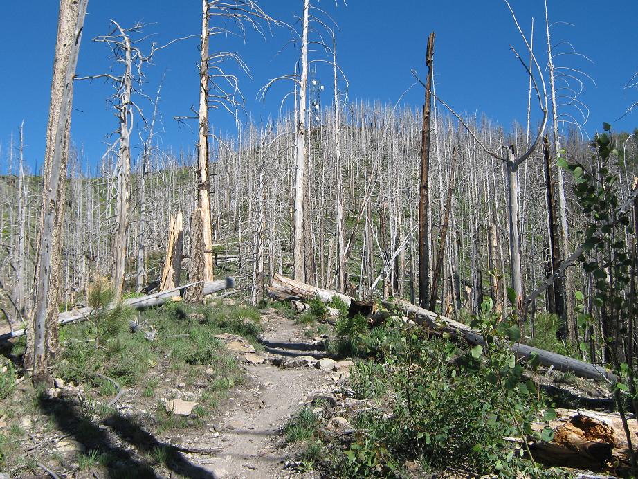
I was up early the next morning, and drove on to the Marshall Gulch trailhead. I got my stuff all set and started hiking just before 7 a.m., the second car in the parking lot. I followed the Marshall Gulch trail up Marshall Gulch and its running stream. The fire damage wasn't too bad here, but about a half-mile in, the damage was more evident. In 1.2 miles the trail surmounted Marshall Pass and the junction with the Aspen Trail. From here to the top the trail went through the burn area. Nothing but dead tree trunks the whole way up, but there was much undergrowth sprouting, The hiking itself was straightforward. The trail gets steep in places and the dirt still has a lot of fine ash in it. The trail gains onto Radio Ridge, then pushes to the top, where the first of many communications towers sit. This stretch was another 1.3 miles.
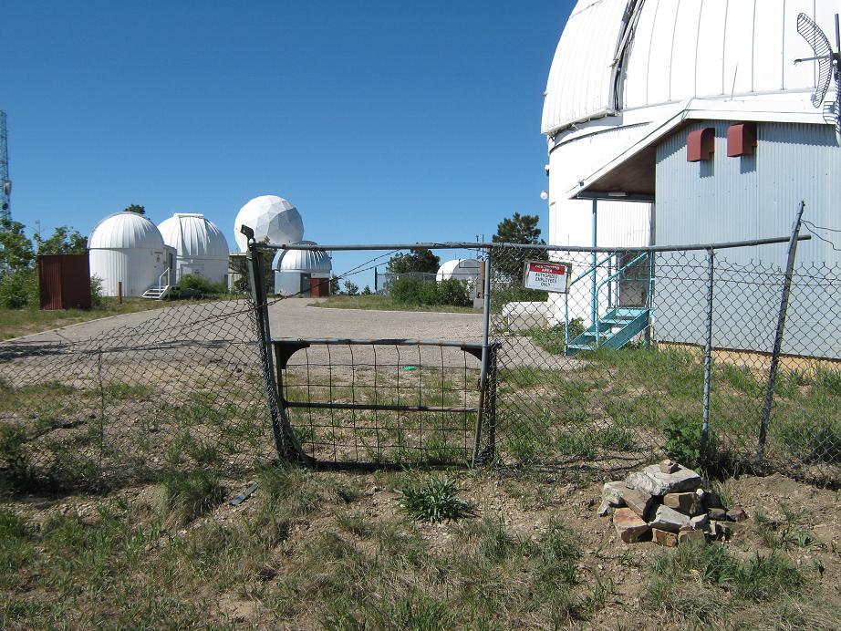
The remainder of the hike to the summit was along service roads. The observatory was closed so I went around the perimeter of the fence to the north end. I had never visited the north end of the summit area before, and suspected I might have missed a rock pile that might be the highest point. When I got there, there was a cairn but the highpoint itself was about 50 feet inside the observatory area, a couple feet higher than the cairn. This part wasn't that interesting, but at least I could say I was there.
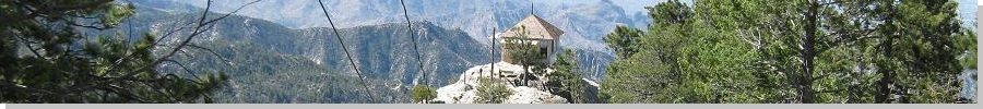
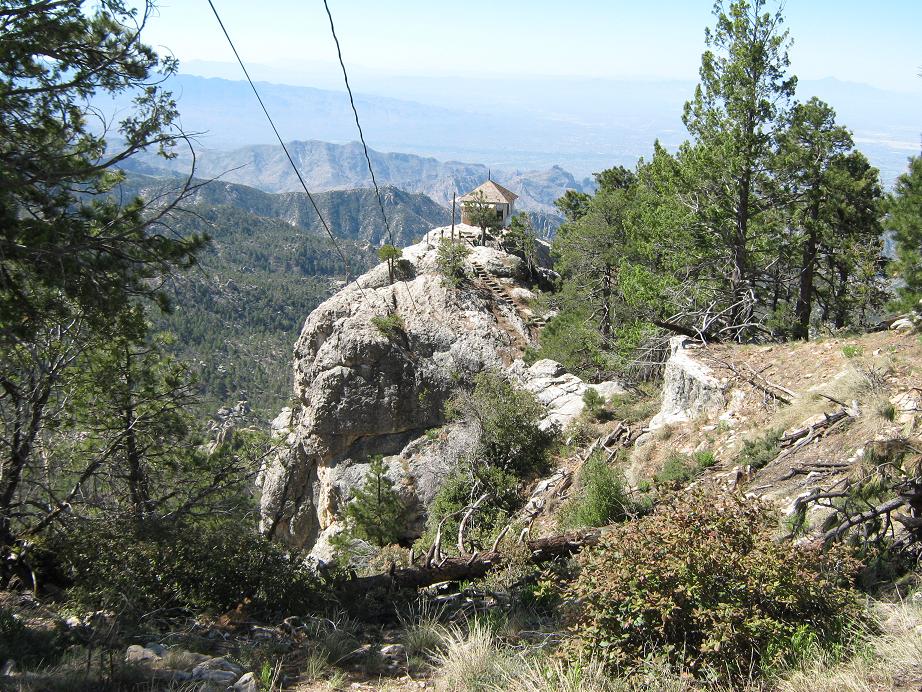
I hiked back out and took a side trip to the Mount Lemmon Lookout, situated on a rock promontory south of the summit area, with phenomenal views to the west, south and east. Dave was the lookout man and we had a good chat. He filled me in on the details of the Aspen Fire from 2003 and told all sorts of interesting stories. His dog Gus was helping him out. We talked 20 minutes. A decent guy.
I retraced my route back to my truck at Marshall Gulch, amused to now see about 40 vehicles and a hundred people all over the place, hiking, picnicking and having a merry old time. I was even more amused to see a message written in the dust of my truck's shell from my Tucson pal, Scott Casterlin. What a small freaking world sometimes. Then, a few minutes later he rolls up in his car. He'd been hiking up here with his friend Katie. The three of us went into Summerhaven and got snacks at the General Store, killing about an hour of time. After saying our goodbyes, I made the long drive home, stopping for a meal at the Cracker Barrel in Casa Grande, which seems to be habit for me now, given I've stopped here now about half a dozen times after hikes. I was home by 4 p.m.
|


|