The Mountains of Arizona
• www.surgent.net
|
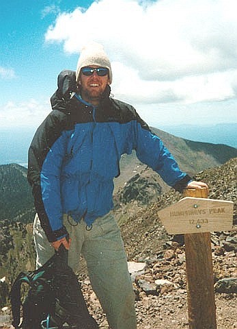
| Humphreys Peak |
• Highpoint: State of Arizona • Highpoint: Coconino County • Highpoint: San Francisco Peaks • Highpoint: Kachina Wilderness & Coconino National Forest • San Francisco Volcanic Field |
. . . . . . .
Summit Panoramas
Computer generated pan- oramas from the summit, as created by Jonathan de Ferranti, a map-wizard based in
Scotland. His highly-detailed images describe the distant horizons, ranges and peaks, with compass bearings and distances provided. They are remarkable and, in my opinion, beautiful works of artPlease check them out!
|
Dates: (1) July 11, 1994; (2) June 14, 1997; (3) September 13, 1997; (4) September 26, 1998; (5) July 3, 1999; (6) June 13, 2003
• Elevation: 12,633 feet
• Prominence: 6,039 feet
• Distance: 9.5 miles
• Time: Usually 7 hours
• Gain: 3,300 feet
• Conditions: Nice, sometimes windy, had clouds and fog on 3rd visit
Arizona
•
Main
•
AZ P1K
•
PB • LoJ
•
Interactive map
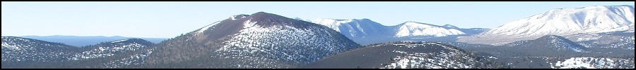
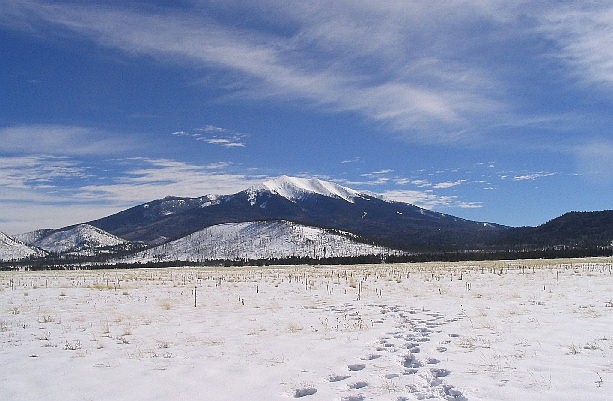
Humphreys Peak may be the best-known mountain in Arizona. It is the state's highest mountain and one of only two peaks to exceed 12,000 feet in elevation (nearby ridge-bump Agassiz Peak is the other), and contains the only alpine life-zone environment in Arizona. Due to its status as the state highpoint, it attracts hikers from all over the country, even internationally. As far as big western peaks go, climbing Humphreys Peak is not difficult since it features a trail all the way to the summit. Most try it in the summer and fall months, while more experienced climbers can make the summit during winter's snowy conditions. Spring usually means a lot of mud. When driving toward the range from the south via Flagstaff, the mountain is obviously visible, but Humphreys Peak itself is not visible, hidden by the foreground peaks. What seems like the highest points is actually Agassiz Peak and Fremont Peak.
Humphreys Peak is a rim-point along the ancient caldera of a once-gigantic stratovolcano that may have risen close to 16,000 feet in elevation. The volcano is now extinct, but volcanism still exists in the area. Some time in the distant past the mountain blew up, similar in manner to the 1980 Mount Saint Helens blast. The mountain blew sideways, sending everything eastward and reducing the summit by a few thousand feet in the process. The series of hills and mountains east of Humphreys are remnants of this old blast. The collective remains of this once mighty volcano are grouped together as the "San Francisco Peaks". A large swath of land north, east and west of Flagstaff, roughly 70 miles east to west and 30 miles north to south, is known as the San Francisco Volcanic Field and features hundreds of volcanic peaks and mounds. The newer features are on the eastern part of the volcanic field, the youngest being Sunset Crater, dating just under a thousand years ago.
Despite its seemingly tame nature, Humphreys Peak can be a tough customer for those who come unprepared, or if the weather turns south. Thunderstorms build fast, and high winds are common along the upper ridges. The elevation can sometimes knock people flat, especially if they show up without any acclimation. Personally, I have been on the mountain over a dozen times, including six successful summits, two failed attempts, two winter search-and-rescue training missions, and other visits on the mountain where other summits were the goal. I have been on the mountain in calm, beautiful bright blue conditions, and in white-outs, storms, and winds that nearly blew me over.
The driving and hiking is straightforward: From Flagstaff, follow the signs to the Grand Canyon, getting onto US-180 westbound. About 8 miles out of Flagstaff, take the Snowbowl Road up another 7 miles to the parking areas. The hike starts at the lower Snowbowl parking lot at a large information kiosk. The trail cuts diagonally across the ski area and enters the trees at the Kachina Wilderness boundary. It is a well-constructed trail and easy to follow. About a half-mile in, the trail comes to a T-junction; turn left (going right leads to the upper buildings of the ski area). From here, the trail makes four or five long switchbacks up the west slopes of the peak. Views are minimal due to the trees, but nearer the top the trees thin and the views west over the Coconino Plateau are astounding.
The trail then gains toward Weatherford Saddle between Humphreys Peak and Agassiz Peak. Here, the trees are virtually gone. Also, the trail gets steep in places but not difficult. Weatherford Saddle is at 12,000 feet elevation and offers an excellent place to stop for a break. It is tempting to hike up Agassiz but due to the sensitive biota, hiking it is not allowed except in winter when it is under snow. The remaining mile to Humphreys Peak is along the west crater rim. The trail loses itself in the rocks sometimes but the going is easy and logical. A handful of false summits await you before the true summit. Overall the hike is 4.5 miles one-way, with about 3,300 feet of gain. It usually takes me between six and seven hours round trip.
My summaries of my hikes:
First Attempt (July 1993): My first attempt didn't go well, due to weather and my own inexperience. Driving up from Phoenix I arrived at the trailhead around 7 in the morning and started hiking ... the wrong way. I followed a lesser path on a wrong bearing from the kiosk signs. I walked across the ski run, into the trees, across more meadows, more trees, meadows, trees, meadows... and knew I was lost. No big deal, I figured. I started hiking uphill and in time I intersected the trail. I was relieved.
I followed the trail up to Weatherford Saddle where I came upon snow and white-out conditions. The winter of 1992-93 had been a wet one and there was still a lot of snow on the peak, which is atypical for July. I tried to follow beaten paths but had just 5 feet of visibility, so I bailed. The hike out went fine (I saw a big porcupine, which they say is rare) but when I got back to my truck I discovered I had left my lights on, and my battery was dead. Some work guys gave me a jump, and I headed back home considerably wiser, and 0 for 1 on the peak.
Second Attempt (July 1994): In excellent weather, I took the Humphreys Peak Trail from Snowbowl to the top. There was not a cloud from horizon to horizon, and the North Rim of the Grand Canyon was visible, 70 miles to the north. The weather was spectacular and I had a wonderful hike. I was now 1 for 2. This was my third state highpoint.
Third Attempt (June 1997): I went up with college friends A. and J. (Whitney, '92), and J.'s fiance, M. We had cool, nice weather but with strong winds near the top. Same route as before. Now 2 for 3.
Fourth Attempt (September 1997): I kept a long-standing promise to take my friend K. up Humphreys Peak. Her friend D. also came along. The mountain was socked in with clouds from the monsoon storms the night before. I stayed with K. while D. literally ran up and down the peak. We went slow but summitted in dense fog with no views. Coming down, it started to rain and one bolt of lightning prompted us to jog down the route back into the trees. Now 3 for 4.
Fifth Attempt (January 1998): My first winter snow conditions attempt. I went with a group of five total. Weather had been dry and we hoped the snow had consolidated well. I had a brand-new pair of snowshoes, and I am glad to report they worked great. However my tummy not so great. I got nauseous half-way up, keeling over and nearly throwing up a few times. I really felt out of it. I could barely walk 5 feet without feeling like I was going to die. What's the deal? I realized I may have a touch of altitude sickness, so I stopped (I was about 11,800 feet) and returned to the ski area, waiting for the others. I was now 3 for 5.
Mountain Rescue SAR Alpine & Avalanche Training (February 1998): This was an exercise for our Mountain Rescue Unit. There were nearly forty of us, from Central Arizona Mountain Rescue (CAMRA; my group), Southern Arizona Rescue Association, Grand Canyon NPS Search and Rescue and the Northern Arizona Search and Rescue Association. We began our climb around 7 a.m. in about 8 inches of new snow. We all plowed through the powder to the 11,400 foot level near an old World War II Bomber crash site on the west face of the peak, where we dug snow caves for an overnight stay.
During the evening, a storm blew in, dropped about another foot of powder, and created nasty avalanche conditions on the bare slopes below the summit and above us. We did not bother to try for the top. Instead, we did some basic training exercises, including digging big pits and recognizing the layers of snow and learning how avalanches form. It was interesting. But at this elevation, some people really suffered, and I think we had a few cases of Altitude Sickness among the group. I felt mostly okay but lethargic. At this point in my life, I think this was the second-highest elevation at which I had camped. The hike out the next day was fun, snow-shoeing in powder through the trees and avoiding the skiers.
Sixth Attempt (September 1998): I went up with Mountain Rescue pal J. for the exercise. We made excellent time and passed a lot of people. Winds at the summit were extremely strong. I literally crawled up the final 100 feet. The hike down went fast, although I slipped once and took a pretty hefty spill. Total time: 7 hours, including a total of one hour of stoppage at the saddle and the summit. Now 4 for 6 on the peak.
Seventh Attempt (July 1999): I was joined by a couple people from ASU's Math Department. We arrived at the trailhead at 6:30 a.m., dismayed by the cloud cover on the top of the peaks. We began hiking in, taking a leisurely pace, not entirely sure whether the summit was possible with the clouds (and possible storms). Around 9:30 a.m. the clouds began to drift away and I made a push for the top. I arrived to the summit around 11 a.m. The winds were strong and clouds drifted up and over the top, but the views were tremendous. The hike down was pleasant and I arrived back to my truck by 2:30. The others generally did their own thing. 5 for 7.
Mountain Rescue Alpine Recertification (February 2002): We (CAMRA) had to re-certify in Alpine Rescue, so we drove up to Humphreys Peak for our recert. This was a dry winter and there was barely any snow on the ground. We found enough to make snow-anchors, dig trenches, do an avalanche beacon-and-pole search, and enact a few scenarios. We did not build any snowmen or forts. We passed our re-cert, because we're awesome. The best thing afterwards was the big meal in town when all thirty of us all crammed our smelly butts into a little Italian place in Flag.
Eighth Attempt (June 2003): βð gave me a late birthday gift: a weekend at the Ski Lift Lodge just north of Flagstaff on the main highway out of town. The lodge consists of a handful of bungalows and is located at the junction of the main highway (US-180) and Snowbowl Road. We arrived Friday evening and toured downtown Flagstaff, enjoying a dinner at Charlie's, in the Weatherford Hotel.
The next morning, we hiked up to Humphreys Peak, starting on the trail around 8 a.m. We were in no hurry due to the clear and windless conditions. After a long break at the Weatherford Saddle, we arrived onto the summit at noon. Unlike my last couple of times at the top, there was no wind. The downside was the number of bugs and flies up this high. But the views were spectacular and we had a great time.
I counted 27 people on the summit, with a few dozen more either going down or coming up the trails. It was by far the most crowded I'd ever seen the peak. I'm guessing a lot of people in the Flagstaff area awoke to a beautiful morning and decided on the spot to hike the peak. Our hike down went quick, and one woman had counted the number of people who signed in at the register at the start: 166 for the day (so far). We saw numerous people still going up, and a lot of people just out for an amble on the lower slopes. Who can blame them? It was so clear and beautiful.
Our round trip took 7 hours, and were grateful to have our hotel so close. We showered and rested, then went back into town that evening for a celebratory dinner at a Mexican food place. The next day, Sunday, we used our complimentary ski-lift vouchers given to us by the hotel and rode the ski lift to the 11,500-foot level on Agassiz Peak's west slopes. I had never done this before and it was a unique position from which to view Humphreys. We stayed here for about 30 minutes then rode down. I was now 6 for 8. I have not attempted Humphreys Peak since this climb.
A few more comments on Humphreys Peak:
This hike is probably the easiest state highpoint of all the western states. The trail is well maintained, it's easily done in a few hours and it doesn't have any portions of extreme exposure or requiring technical expertise. However, Humphreys makes up for its relative ease by its fickle weather. Summer thunderstorms are tremendous, extremely dangerous and they build up FAST! It can go from blue, cloudless skies to big puffy thunderheads and lightning in about 30 minutes time. I kid you not. It has happened to me once. If you go up during the monsoon season (usually July-August), plan to be entirely off the mountain by noon, which means a 5 or 6 a.m. start.
I cannot make this point strong enough: start early! The summer storms are powerful and terrifying, and they build fast. I have been caught in one. The damn thing literally billowed up out of nowhere in thirty minutes, dropping lightning and hail. I read reports at various hiking sites like Alltrails and shake my head at the number of people who mention starting their hike at noon or somesuch. This is not a mountain to mess with. If the storms build and you're caught up high, you're in deep trouble.
The peak is named for Gen. Andrew A. Humphreys of the United States Army, a member of the Ives Expedition of 1851. The peak is always referred to as Humphreys Peak, not Mount Humphreys, nor with an apostrophe such as Humphrey's. The Navajo consider the peak to be one of its four sacred mountains and the traditional western boundary of its homeland. The Navajo call the peak Dook'o'oosłííd, meaning "place that never melts" or "shining on top". The Hopi call it Nuva'tuka'ovi, "snow on top", and consider it a home of the kachina. The Havasupai call it Hvehasahpatch, "Big Rock Mountain", the birthplace of the Havasupai people, while the Apache name it Dilzhe'e, where the "earth brushes up against the unseen world".
|


|