
The Mountains of Arizona
• www.surgent.net
|
| Hualapai Peak |
• Hualapai Mountains Park • Highpoint: Hualapai Mountains • Highpoint: Mohave County |
|
Date: (1) May 13, 2000; (2) October 18, 2003
• Elevation: 8,417 feet
• Prominence: 4,437 feet
• Distance: 8 miles
• Time: 5 hours
• Gain: 2,200 feet
• Conditions: Cool the first time, sunnier and hotter the second time
Arizona
•
Main
•
AZ P1K
•
PB • LoJ
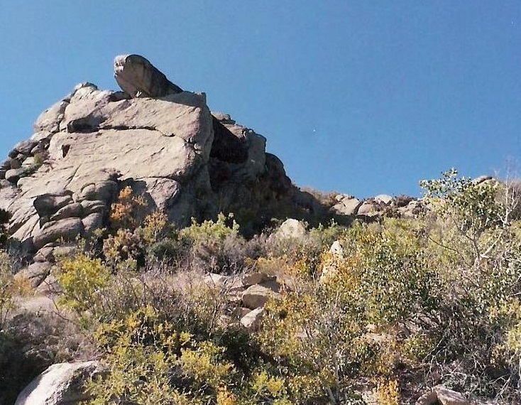
Hualapai Peak is the highpoint of the Hualapai Mountains in northwest Arizona, south of Kingman. The hike to the top follows trails, an old road, with a bit of bushwhacking and rock scrambling at the top. Much of the route is interspersed with massive granite rock extrusions, and the views (in parts) are quite dramatic.
May 2000: With my teaching duties done for the semester, I drove to Henderson, Nevada, to visit my parents and hike a couple peaks. When I arrived in Henderson on the 12th, I found out from my dad that my sister-in-law was in labor with her first child, and that my mom had already left for Southern California to be present for the birth. I thought about cancelling my hikes, but my dad said to go have fun. Even if the baby was born now, we wouldn't drive out for at least another day or two.
The next morning, I drove to Kingman, then south to the Hualapai Mountains Park. The plan was to meet up with Ken A., with whom I'd hiked before, and a group of hikers he was supposedly leading from a hiking club in Tempe. I showed up at the trailhead about 30 minutes late, saw Ken's vehicle and a few other vehicles, and assumed they'd already started in without me. I got packed and started in myself about 9:30 in the morning.
I started up the Aspen Peak trail. This trail gains at an easy grade and bypasses huge rock slabs seemingly plopped onto the mountainside. After 0.9 mile, the trail comes to the Potato Patch trail junction, where I turned left. This section traverses on the east and south faces of Aspen Peak, with superb views along the way. It passes a bench and a shelter, where views of Hualapai Peak are now possible. It then starts a decline to a point where it meets an old forest road.
The temptation here is to stay straight and climb up to Hayden Peak, which is the peak north of Hualapai Peak. Presumably, one would then traverse the ridge from Hayden to Hualapai, but a visual inspection of the ridge shows numerous rocks and cliffs, not to mention lots of brush, in the way. Armed with Bob Martin's Arizona's Mountains book, I knew to hang a hard left at this junction, and follow the road downhill to the south. This seemed counter-intuitive, but I knew I could trust Bob. The total descent is roughly 300 feet, then the road makes a steep ascent to a small saddle. This point is about 3 miles from the trailhead and 1 mile from the peak.
The remainder of the hike is up this poor quality road. Erosion has exposed the bedrock and trees now lie in the road, so I'm assuming they (whoever they are) are letting the road return to nature. I walked this steep road all the way to its end at a small shack with random antennas, just below Hualapai Peak's summit. However, climbing the summit from here was above my skill-set, so I backtracked about 200 feet to the last switchback and started hiking up a steep slope through thick brush and rocks. I had to avoid a beehive hanging from a rock overhang.
Finally, I was high on the ridge and just a few feet below the summit's top-most slab. I frictioned my boot into one good foothold, then hoisted my knee up on top this slab. I tagged the top, but didn't want to remove my foot from that hold, so I eased down and back onto safer ground, where I ate lunch and enjoyed the views. This was my thirteenth Arizona county highpoint done, just two to go. After a few minutes, I started the descent. Curiously, I had not seen Ken or anyone from his group the whole time.
I was back on the road when Ken shows up. I was wondering where he had been because I should have passed him at some point. It was just Ken, no one else from this alleged hiking club wanted to come this far. He explained he had climbed Hayden Peak then tried to traverse to Hualapai Peak, giving up due to the brush and cliffs. We talked for a few minutes, then parted ways. At least he's alive, I thought. I told him about the bees. I was back to my vehicle within a couple hours.
Naturally, I was curious if I was an uncle yet. I stopped at a gas station in Kingman and called my dad, but no, the baby was still in her mom's tummy. But ninety minutes later when I arrived back in Henderson, I was met with the good news. Little E. had arrived into the world, healthy and gorgeous. I cancelled my second hike and drove with my dad the next day to California to meet this beautiful new person.
Second visit, October 2003: We drove to Kingman and stayed the night at the Hotel Brunswick, an old-timey hotel from the 19th-Century along old US-66. The price was reasonable, and as is common with these old hotels, supposedly haunted. However, we slept well that night, no ghosts or spirits to bother us.
We drove to the trailhead the next morning, starting our hike at 10 a.m., in clear, warm conditions. We followed the same route as I took in 2000, since there really is no other choice. We made good time, but the flies were bothersome and drove us nearly insane. What is it in my ear they want so badly? After a couple hours, we found ourselves at the base of the final scramble. I changed into long pants, while & scampered up ahead of me and out of view. The brush was thicker than I recall, probably because it was late in the season.
We got to the base of the summit slab. I did the same thing as I did before, which was get most of the way up and tag the top. βð, more limber than I, chimneyed up between the slab and some nearby rocks to get her head about summit-high, then she reached up and tagged the top, too. We then sat on a nearby set of rocks and relaxed. The views on this clear day were outstanding. Wabayuma Peak was to the south and Hayden to the north. We could see Kingman and the Cerbat Range to the north. After a few minutes, we made our way back down and hiked out, everything going well except for them dagburned, consarned, blashgummit flies.
We drove down to the living ghost town of Oatman and its tame burros, and spent the night in Laughlin. The next day, we drove home. It was unexpectedly hot, and later, we would discover that it had been over 100° F along the Colorado River and in Phoenix, the latest 100-degree reading on record.
|


|