
The Mountains of Arizona
• www.surgent.net
|
| Harquahala Mountain |
• Highpoint: Harquahala Mountains • Harquahala Mountains Wilderness • Highpoint: La Paz County |
|
Dates: (1) April 19, 1997; (2) February 14, 2004
• Elevation: 5,681 feet
• Prominence: 3,461 feet
• Distance: 16 miles in 1997, 11 miles in 2004
• Time: 7 hours in 1997, 6 hours in 2004
• Gain: 3000 feet in 1997, 3,360 feet in 2004
• Conditions: Lovely both times
Arizona
•
Main
•
AZ P1K
•
PB • LoJ
Harquahala Mountain is the highest peak in southwest Arizona. The range is about 75 miles west of Phoenix, and is conveniently viewed from Interstate-10 at the Maricopa-La Paz county line, near Avenue 75E. Looking north, it's the obvious high mountain about fifteen miles to the north. It is notable for once hosting a solar observatory about a hundred years ago.
In 1920, a solar observatory was constructed on the summit and functioned for five years before being dismantled and abandoned for a newer site closer to San Diego. The few hardy workers and scientists that worked for the observatory lived atop the summit and relied on a mule team to provide supplies. A 5.4-mile long trail snakes up the mountain's north slopes and was originally constructed for the mule-teams and later adopted and maintained by the Bureau of Land Management. The one building that survived intact was placed on the National Registry of Historical Places in 1975 and much of the mountain range was declared a wilderness area in 1990. The main building, which apparently housed both the equipment and residences, has decayed over the years but still stands, wrapped in corrugated tin and surrounded by a chain-link fence. It is too fragile and dangerous to allow people inside.
In 1983, the Central Arizona Project (CAP) constructed a modern radio transmission and gauging facility on the summit as part of its management of the hundreds of miles of canals running from the Colorado River toward Phoenix and Tucson. A four-wheel drive road was built to reach the summit on the mountain's south and is open to the public. Today it is known as the Harquahala Mountain Back Country Byway. The top holds the CAP buildings and solar collectors, a windsock at the summit itself, the observatory building, many informative signs, benches and a picnic table. The summit is often shared by hikers, people in jeeps, and motor-bikers.
First Visit, April 1997: My first visit to the range came as a result of curiosity about the mountain derived from the many road trips I have taken along Interstate-10. I was not yet into county highpoints and none of my hiking guidebooks had much to say about Harquahala Mountain. The only strong lead I had seen was an article in the Arizona Republic newspaper talking about the old observatory and the grueling hike it takes to get there.
I did some searching on the web (what little was possible in 1997) and came across information about the mule path, and set out to hike the peak via that route. I left home early in the morning and drove northwest out of Phoenix, past Wickenburg and the little town of Aguila along US-60, and to the La Paz county line sign, which put me nearly due north of the summit. Here, I had no idea where to enter, but I found an old road and decided to try that. I parked my vehicle along the highway, hopped the fence and hiked in along the old road about two miles until it started up the lower foothills. Then the road ended, and I had no idea where to proceed, and after an hour of trying things, I bailed and returned to my car. I scouted the south side on my way home, following Salome Road. I noticed the road-cut high on the mountain and decided to try that route the following weekend.
A week later, I drove Interstate-10 west about 70 miles to Salome Road at Exit-81, then went northwest along Salome Road nine miles to Eagle Eye Road. I went north along Eagle Eye Road another 10 miles to the Harquahala Mountain Road sign, and drove in about 3 miles and parked where the road got too rough for my low-slung passenger car. I then marched up eight more miles of road to the summit. There were a few heavily eroded sections down low, sandy spots here and there, and crumbly rock up high, but in about 4 hours, I had arrived to the summit, where I relaxed and toured the various buildings. The weather was superb and beautiful, and I had the top to myself.
After a half-hour break, I returned the way I came in. It took me 3 hours to hike down, and I was tired when I got back to my car. I was pleased to have had a successful day hike of this pretty peak, and it was as advertised: a remote and very interesting journey. I may have never returned, but then I got married...
Second visit, February 2004: We left Phoenix after work and drove to Salome, following Interstate-10 to Salome Road into Salome. Salome (pronounced Sa-loam) is a little town of about 500 people along US-60. In the old days before Interstate-10, US-60 was the main Phoenix-California highway, and a number of little towns sprung up along its fringes. Since Interstate-10 was completed back in the 1970s, US-60 has remained open but sees just a fraction of the traffic it used to. It's a mix of old buildings, some abandoned, trailer villages, and little towns. We stayed at the Scheffler's Hotel.
We checked in, then went across the highway to the Salome Cafe for a meal. The food was good. The waitress was a high-school girl who chatted with the people at the three tables she was serving (ours included). She hates Salome. It's too boring and hard to get dates. She wants to either go to school in Yuma or become a corrections officer. When one guy asked her where the high school was located, she said "on School Road". Ah yes, of course, we all knew that. On top of all that, she was mad at her co-worker, a guy about her age who apparently wasn't doing his duties fast enough, and the lady who was the cook was also yelling at him, and he was yelling back, but not angrily. We crashed back in our room about 10 p.m..
The next morning, we drove 13 miles east along US-60 to a gate along the highway that is the entrance to the trailhead for the hike. The gate is located at about milepost 70.4, on the south side of the road. Once inside, we went right and followed the road southeast 2.1 miles to a developed trailhead. A parking area, pit toilet and information sign are at the trailhead, which is at elevation 2,320 feet. It was about 8 a.m. when we rolled up, and quite cold, nearly freezing.
We started hiking at 8:15 a.m. Shortly we came upon a small sign marker detailing the original location of a garage where vehicles used to be parked and the mules loaded to start the trek up the peak. Nowadays there's nothing there except a metallic tank and numerous food cans and other trash items, obviously from that era. We continued up the trail as it gained elevation, never too steep, always just about right. We took our first break at 9:15 and using GPS, noted our location. We had gained a thousand feet and were just east of a prominent rock knob at 3,645 feet. We rested here 15 minutes then got moving again.
We followed the trail as it entered into the heart of the range and started zig-zagging up prominent ridges. Again, the gradient was never too steep, and we made excellent progress. We passed a stand of saguaro cactus and took another breather at elevation 4,400 feet about 10:15 a.m. This was close to a transition zone, as we went from scraggly thorny desert scrub to grassier slopes.
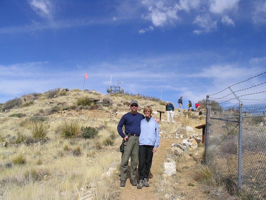
We soon passed the remains of an old mining shack, then started up the only "steep" section of the entire hike. Even then it wasn't too bad. We could see the ridgeline not too far off, and motivated by this, we made great time, arriving at the ridge at 11 a.m., where we again took a quick rest. We could also see the 4-wheel drive road coming up from the other side, and we soon saw (and heard) the rumbling of a jeep slowly making its way up this road. We also had sight of the summit now, just a short way east. The three main "markers": the observatory hut, the windsock and the radio tower, were all in view.
We hiked up the remaining short section and achieved the top at roughly 11:45 a.m. The jeepers were already there, just looking around. We walked to the summit rocks near the windsock. The jeepers saw us but didn't wave. In fact, they got moving pretty quick. We then sat at the top, relaxed, shot a couple of photos, then heard the whine of motor-bikes. I looked down and could see a couple of bikes way below. We walked down to the picnic table, started eating and were soon joined by the foursome of bikers: three brothers and their dad. The younger brothers were about 12.
They asked us how we got up and when we told them, they seemed pretty surprised anyone would want to hike the peak. They wondered if they could take dirtbikes down the trail we came up and we said it would be impossible. They only stayed a few minutes as well. Lastly, a group of six hikers from Prescott followed us and joined us. In all, we stayed an hour on the summit, touring the buildings, and waiting for the rest to leave. We were the last to leave, starting down at 12:50 p.m.
The hike down went great and very fast. We took breaks at roughly the same spots as we did coming up, and aside from the expected fatigue toward the very end, we exited in exactly 2 hours. The weather had warmed nicely and we relaxed at my truck at the trailhead. Our round trip had taken 6 hours, 35 minutes, but really just about 5.5 hours of actual hiking time. We covered 10.8 miles round trip and 3,360 feet of vertical gain.
We drove back to Salome, where we found that our neighbors at the hotel had been "evicted", their clothes and stuff piled by their door. We went for a meal at a little place in Wenden called the Brooks Outback ("Hot Beer and Lousy Service"), then back for a night of relaxing at the hotel. Our evening was highlighted by three full hours of Law and Order television shows, and the cursing of our neighbors when they showed up to see their stuff outside. The next day we went back home via Wickenburg (attending the Gold Rush Days event) and a stop at the Vulture Mine south of Wickenburg.
|


|