
The Mountains of Arizona
• www.surgent.net
|
| Browns Peak • Four Peaks |
• Highpoint: Maricopa County • Mazatzal Mountains • Tonto National Forest • Four Peaks Wilderness |
. . . . . . .
Summit Panoramas
Computer generated pan- oramas from the summit, as created by Jonathan de Ferranti, a map-wizard based in
Scotland. His highly-detailed images describe the distant horizons, ranges and peaks, with compass bearings and distances provided. They are remarkable and, in my opinion, beautiful works of art. Please check them out!
|
Dates: (1) September 26, 1999; (2) December 15, 2006
• Elevation: 7,657 feet
• Prominence: 3,297 feet
• Distance: 5 miles
• Time: 5 hours
• Gain: 1,700 feet
• Conditions: Clear and dry both times
• Teammates: Ken in 1999; Andy Martin, Sarah Martin, Bill Jacobs and Rick Hartman in 2006
Arizona
•
Main
•
AZ P1K
•
PB • LoJ
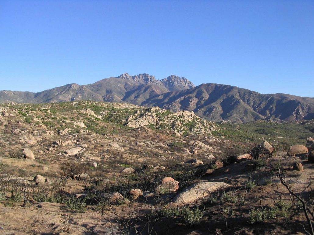
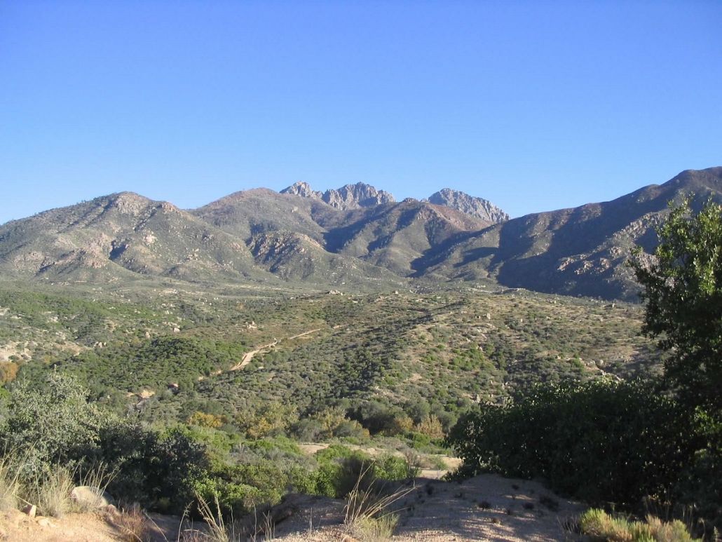
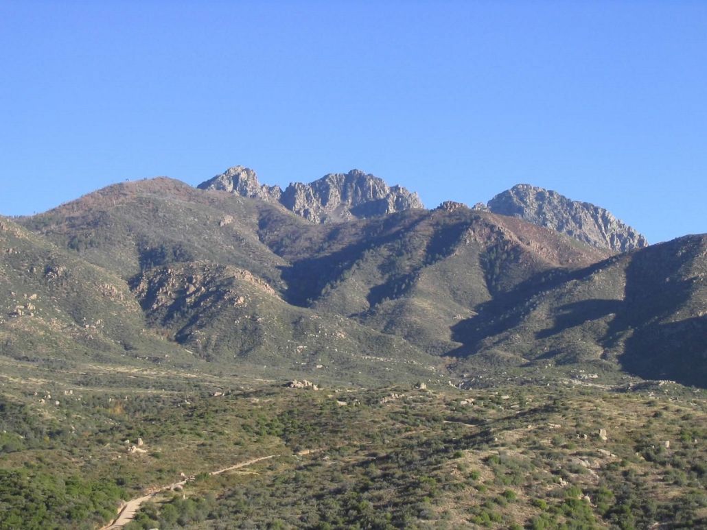
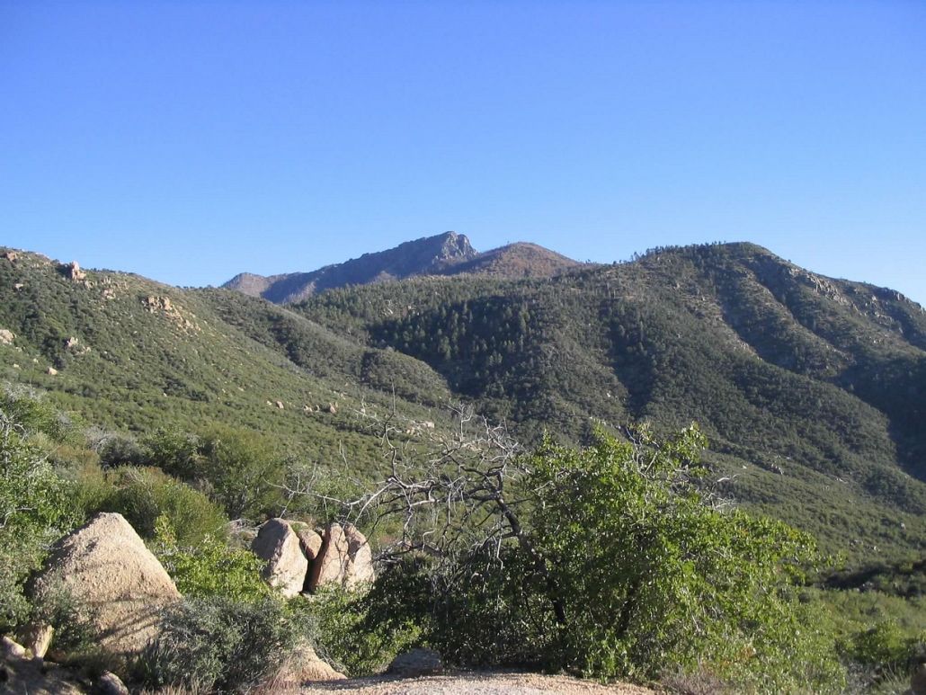
Browns Peak is the highest of the Four Peaks of the Mazatzal Mountains in central Arizona. The Four Peaks are a serrated ridge of four summits, the left-most (as veiwed from the Phoenix) being Browns Peak. The next highest is the one immediately to the right, just 13 feet lower. The peaks lie along a northwest-southeast alignment, with Browns Peak sitting along the Maricopa-Gila County boundary, and the other three peaks being within Maricopa County.
A decent road (Tonto Forest Road 143) runs 17 miles from the Beeline Highway (AZ-88) to the range crest. A spur road leads from there to the trailheads for the Four Peaks, while the road itself continues down the opposite side of the range for another 10 miles, meeting State Route AZ-188 near Roosevelt Lake. In normal conditions, the road on the Phoenix side is rough and high-clearance is advisable, while it is usually nicer on the east side (due to the lack of use). In wet conditions, the roads can be treacherous.
A good network of trails surround the Four Peaks, although the route to the summit is a steep, brushy use-path requiring a lot of patience, route-finding skills and a little courage to deal with small segments of exposure. This may be the toughest of the 15 county highpoints in Arizona. Plan on getting lots of scratches if you go. Other trails go along the west and east sides of the peaks, including one on the west that gets close to an active amethyst mine high up on the flanks of the fourth (right-most) peak. People actually live in small pre-fab buildings up there, ferried in by helicopter.
I have been up on the Four Peaks and surrounding areas many times over the years, four trips as a member of the Maricopa County Sheriff's Mountain Rescue team on rescues or trainings, and four other times on my own to seek out the summit or go for other hikes. I have achieved the summit twice. I have been up here in beautiful fall weather and horrible winter and spring snowstorms, including a blizzard in 2001.
First Successful Ascent, September 1999: One night in September 1999, I was sitting at home and my phone rang. The caller was Ken, a name familiar to me from the National State Highpointers Club. Apparently he just moved to Arizona, had the list of members living in Arizona, I was closest, and he called me. My life would change forever.
He was interested in the county highpoints of Arizona. I had a passing interest in the list but had made only token efforts to hike the other summits. Having lived in Arizona for over seven years by this time, I had hiked just four of the fifteen county highpoints. We agreed to meet at his apartment in Scottsdale. His suggestion was for us to climb Browns Peak, here in Maricopa County. He had maps and everything. He seemed okay, so I accepted his offer and figured I could use the exercise. We planned it for the following weekend.
I drove, picking him up, and then following State Route AZ-87 to the Four Peaks Road, and then the long, laborious drive up this road to the trailhead below Browns Peak. This alone was a small adventure. I had been here just once before, in December 1997, on my first rescue as part of the Maricopa County Mountain Rescue Team. That day was snowy, while today was warm, dry and pretty.
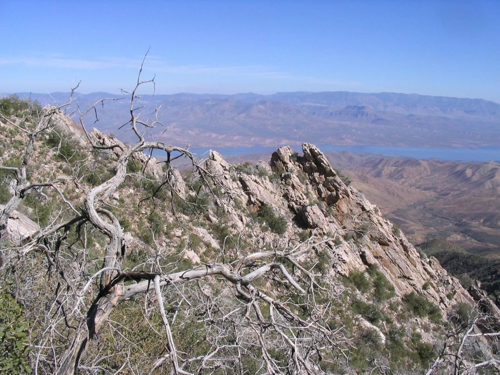
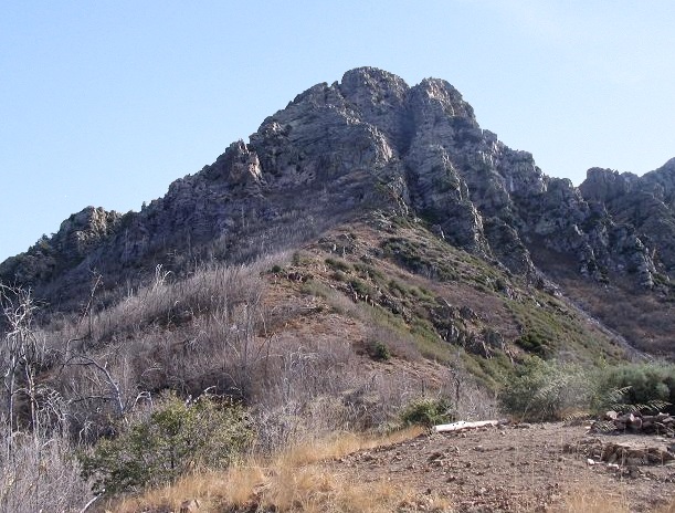
Ken and I hiked up the trail a little over a mile and a half to Browns Saddle, then looked at the imposing summit block, a big rocky peak fronted by steep cliffs and gullies. I was aware of the main gully that leads to the top, but had never actually climbed it, and to be honest, one look at it spooked me and I nearly lost interest in the whole endeavor.
Instead, we angled left and traversed through a thin forest and thick grass, then down into a steep and brushy gully. Turning right, we climbed up this gully, following a path in spots, until we were getting onto more bare rock. The summit was near, but we could not see it and had to guess a few times which path led to the top. We found a way, involving a few steps of hundred-foot exposure. And bam, there we were, on the summit.
We were both happy, and I was gently surprised that I had made it. It wasn't as bad as it looked. There was a father and daughter team up there, the girl about 10, and another guy. They seemed cool and had come up that aforementioned gully. They were cool enough to let us join as they descended it. It wasn't bad. It was steep, yes, but with ample ledges and holds nearly the whole way. Only a couple spots were challenging. Quickly, we were at the base, then after a short sloppy section across scree and rock, we emerged back to the saddle, where we had an easy hike back to my truck.
I drove out the east road (Los Osos Road) to Highway AZ-188 near Lake Roosevelt. We followed highways through Globe and back into the Phoenix area, where I dropped Ken off. Me, I was pretty stoked to have climbed this peak after hearing so many horror stories about it. Given that I can see this peak most days from my home, it was a treat to finally surmount it.
Mountain Rescue Visits: We had two call-outs on Browns Peak in 2001. In April, after a week of 90s in Phoenix, a spring storm blew in and dropped a lot of rain on the deserts, and snow up high. Not surprisingly, we had a call-out: a couple were missing from the high trails surrounding the peak. I recall driving up in rain and snow to the trailhead, and being scared crapless about the roads, but somehow I got my truck to the trailhead, already under 6 inches of snow. It was about 9 p.m. when we arrived.
We were short of manpower. Most of the team were on a training, while just a few of us stayed home. At command, there was just three of us who could go in. We were the "hasty" team, sent in first to run the trail (so to speak) and assess the situation. We had basic gear but not a full complement of technical items. We suited up and hiked to Browns Saddle. It was dark and the snow was coming down thickly, but we made it to the saddle without a problem.
Apparently the subjects were way to the south near the Amethyst Mine, and we spent three hours at the saddle trying to find the trail to them. The terrain past the saddle was utterly treacherous and we had no luck. In dry conditions, this route is scant and steep. In snow, it was impossible. We made every effort to traverse this slope, but encountered impassable snow or terrain quickly. With a lot of discussion and debate, we were forced to abandon our attempt and we returned to command, arriving back at 3 a.m. By this time, others from our team had arrived and the snow had stopped falling. At dawn, the Sheriff sent up a helicopter and presto, found the two, alive, about two hours later. Man, I was relieved.
In October, in good weather, we had a call-out for a father-son duo. I and another rescuer were sent in on a helicopter and as soon as it left, I called out, and much to my surprise, got a response! We radioed back to command and gave the helo guys an approximate search area to shine their lights on, and within minutes the subjects were spotted. We hiked down to them and helped them out. They were fine, other than being out all day, tired and exhausted. As rescues go, this one went by the book.
In January 2003, I joined a few other Mountain Rescue guys for an overnight on Four Peaks. We hiked to a nose near the Amethyst Mine and set up a simple open camp, then hiked out the next day. This was for our experience, plus a so-called "trail guard" program that we ran.
As a result I have seen this peak in the best of times, and in the worst of times. It is no peak to be taken lightly, that is for sure!
Second Summit Attempt, May 2004: I drove up with βð, my second try at the top and her first. We made good time to the main saddle then climbed as far as the base of the gully. We both were a little reticent, and I was eager to re-produce my ascent in 1999, in which Ken and I had taken an alternative approach directly from the north.
We bushwhacked toward this gully ... and quickly got nowhere. We managed to climb high on the mountain, but we got cliffed out about 50 feet from the top. The irony is that we had equal or greater exposure on this route than we would have on the main gully. We had to turn back as it was getting late in the day. So we abandoned the summit and walked back to my truck, and drove home.
Day Hike and Scouting Mission, November 2005: With a good spell of weather lingering into November, and a desire to scout the Four Peaks for alternative ways to the summit, I took off for a day and hiked the perimeter trail that goes around the north and east flanks of the peak. I had never done this popular hike and looked forward to seeing the peaks from these unique vantage points. The drive up to the trailhead went fine and I was on the trails by 10 a.m. in cool, pleasant weather. The Four Peaks Trail goes left at the information sign (the summit trail goes up from here).
The trail is in excellent shape and stays level for the first half-mile (lots of little ups and downs, but a net level gain overall). The trail then dropped 300 feet into a drainage, crossing a small creek that had just a scant flow in it this time of year. A little farther on I heard some pounding: two forest workers digging a hole for a concrete base for a junction signpost. They were pretty cool, and they were the first people I'd seen for this leg of the hike, covering 1.5 to 2 miles.
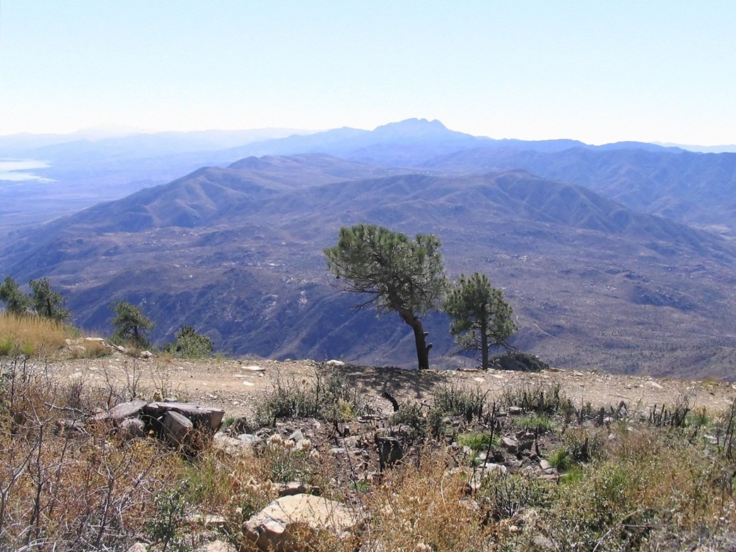
I turned right onto the continuation of the Four Peaks Trail, I was now traveling south on a gentle uphill gradient. Views were mostly blocked by brush and trees, but soon I surmounted a small ridge crest and had unobstructed views of the sheer eastern cliffs of the Four Peaks, and lots of air below me. My map showed the trail continued on, but I couldn't see how they'd hew in a trail here.
I continued on, losing elevation, by gum there was a good trail etched into the cliff faces. Some of the trees were turning color for fall, a beautiful sight. The trail then gains elevation and wiggles its way southeast of Browns Peak, before losing yet more elevation into a drainage. Here, I found the Alder Pass Trail junction, well-signed but the trail itself was way overgrown and obviously sees little visitation.
I barrelled up a sketchy trail choked by brush, and was surprised to come upon another hiker, the first I'd seen on my hike (not counting the forest service guys). We talked for a bit, and I asked him how the trail was up higher, and he said not too good. After a minute or so we went on our ways and I continued up the steepening slopes toward Alder Pass. The trail had sections of downed trees and places where it simply disappeared. I guessed, re-found the trail for a bit, then lost it again. Eventually I headed into the thick chapparal brush and zig-zagged my way up the slopes northwest of Alder Pass. The going was slow and often blocked by brush.
The summit of Browns Peak was about an mile to the northwest, brushy and rocky and cliffy, although it's possible had I been determined enough I could have found a route to the top. But it was close to 2 p.m. and I took a long snack break. I figured at least 3 hours round trip if I headed toward the summit, and the intervening brush was way too thick, so I decided against trying.
After my snack, I headed out for the hike back to my truck, taking about 2 hours to egress. The stats for this hike were: about 7-8 miles for the hike, about 1,200 net feet of gain. Although I missed on the summit, I enjoyed the hike and had a good learning experience. I highly recommend this trail for an enjoyable outing.
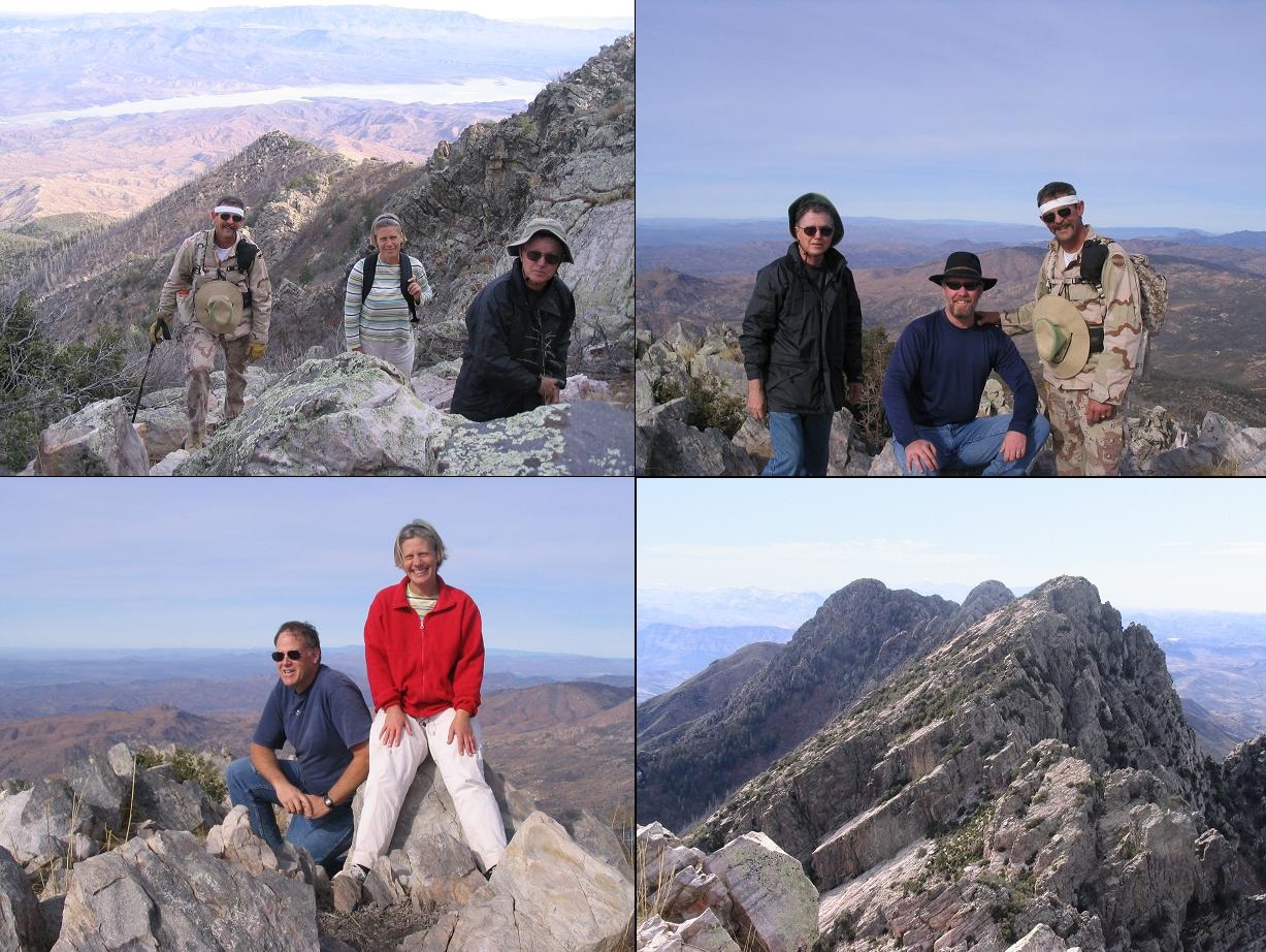
Second Successful Ascent, December 2006: Fellow hikers Bill Jacobs and Rick Hartman were both up to fourteen Arizona county highpoints, needing only Browns Peak to complete the fifteen. I needed only Browns Peak to complete the set of fifteen a second time. We were accompanied by Andy Martin and his wife, Sarah. Andy led us up a use path he had mentioned before. It actually was the one Ken and I followed in 1999, but that I could not remember with my wife in 2004. The foliage was gone from the trees, making movement easier, but even so it was slow, tedious going.
In the brushy gullies even Andy got himself up a dead-end once, but in time we had found a viable route, requiring just a whiff of rock scrambling for the final 30 vertical feet. It was great to be on top again, to complete the state's county list once again, and to congratulate Rick and Bill on their ascents and completions. The weather was tremendous. Footnote: Rick later completed the set of fifteen county highpoints a second time. To date, Andy, myself and Rick are the only three people to have hiked them all at least twice.
I drove down the east side again and home via the Apache Trail. The east side road is far better anyway, and I have decided to take it always for the up and down driving. Even though it's an extra 60 miles of extra driving each way, it's a far better road overall.
|

|