Crossman Peak overlooks Lake Havasu City, parallelling the Colorado River and rising nearly a vertical mile above the river and city. When the temperature is pleasant here, which is usually about a two-week window in winter, a hike up to Crossman Peak's summit is an enjoyable experience, but getting to the trailhead is itself a small adventure.
We don't get to Havasu much. It's not on the way to anywhere, and the roads to it are winding and slow-going. This would be our first (and thus far, only) trip explicitly with Lake Havasu City as our primary destination.
From Phoenix, we drove west on Interstate-10, then State Route AZ-95 northbound into Parker. The speed limits drop fast, from 55 to 25 in about a mile. The city limits are way out in the desert, so naturally, a cop was parked right on the city limits, radar gun in hand, and he motioned for the car in front of me, and me, to pull to the side.
The cop talked to the other people first, then us, then wrote me a ticket for going 45 in a 25 zone, which was false, and a potentially serious hit to my record. So the cop leaves and we sit there. The other people got the same ticket. We talked with them. They were from California and had decided they would just pay the ticket. Sometimes, infractions in one state don't carry over to one's insurance in another state. But us, even if I just paid the fine, I'd have a couple points on my record. We decided to fight it. Read on at the end to see how we did.
We stayed the first night at the Buckskin Mountain State Park, north of Parker, along the Colorado River. We had a ramada, and there were few people here, so it was peaceful. The next morning, we packed up and drove into Havasu, looking for Bison Road, which is the let-in point for the mountains behind the city.
Lake Havasu City is not laid out in any sort of grid. Streets go in long arcs and change name along the way. We had to pay close attention to our street map and we were able to find Bison Road, which is in an upscale part of town. There are very nice homes, then the pavement ends and immediately, we're in the desert again.
We followed the dirt continuation of Bison Road, which was bumpy and rocky enough for me to use 4-wheel drive. In 1.3 miles we came to a wide-open flat area, a staging area for off-road vehicles. The road we wanted was to the left of an old concrete foundation, leading into a prominent wash. A bunch of people on Polaris-type 4-wheel ATVs came rumbling up a slope from the wash, bypassing some poor schmo whose truck was buried up to its axles on this same slope. We continued on, turning right at a T-junction and heading northeast toward the range. The road quality was decent, but bumpy, and the 4-wheel drive helped a lot.
We had in hand a report saying to stay left at a Y-junction. We came to a Y-junction but failed to note our mileage. We stayed left, then stayed on this road another mile, eventually driving to a dry waterfall complex. The report said "the other" road would lead to these falls ... our first hint something wasn't right. A bunch of off-roaders were here at the falls, and when I asked if the road here went to the towers, they all said yes, uncategorically. They're local, I figured. They must know for sure. Mistake number two.
We started the hike, working up a steep jeep path to get above the falls, then the road up the canyon. We hiked about a mile up the gently-sloped road, coming to a Y-junction. To the right were old mines, and to the left, we hoped, was our route, but no such luck. It was clear we were on the southerly of the two jeep roads shown on the map. There was no way we were getting to the top this way. We hiked back to our truck, where a bunch of new off-roaders were goofing off at the falls. We met up with some hikers on our hike out and when I mentioned the towers, they said we wanted "that left turn back there", which we had apparently missed. So when we drove out, we made a point to look for this proper left turn (our right, as we drove out). We found it. The road grader had piled up a berm of rocks at this junction so that it looked like the road was not meant to be traveled on.
I wanted to scout this road, so I drove this road as far as I felt comfortable, covering 1.6 more miles to the mouth of a canyon. Since it was nearly 4 p.m., we decided against hiking, but now had an idea of the distance needed to hike to the top, and made plans to try it the next morning. The area was starting to fill up with more ATVers and target shooters. We surmised this was a popular saturday night "drink-&-shoot" hangout. We drove back into Havasu and found a cheap hotel, along London Bridge Road near the water. (The guy whose truck was stuck to its axles on the slopes had by this time managed to unstick himself and he was gone.)
Early the next morning, we awoke and βð took time to see if her arthritis was going to allow her a good day or a bad day. Turns out her ankles and knees felt pretty good, but her back was out, bad enough that hiking would exacerbate it. So she begged off the hike for today, and agreed to wait for me while she relaxed at a nearby Starbucks. We packed our things, and I dropped her off, then went for the hike. I drove back to where we were yesterday, taking about 40 minutes to get there. It was 9:45 a.m. when I parked and started the hike. The weather had improved from yesterday: it was clearer as opposed to yesterday's high clouds, but it was breezy and cool. A front was passing through to the north, and Vegas was getting some rain.
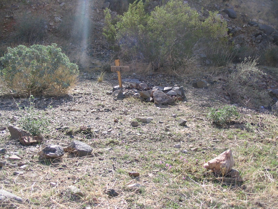
From my truck, I walked the remaining 0.4 mile of road to a sharp right switchback turn. Curiously, a grave was nearby, on a small raised platform off the road. Past the sharp bend, the road goes steeply upslope and around to a locked gate. On the gate was an old sign mentioning this was a "private drive" and "no trespassing" in small letters. A newer sign from the tower company was on the gate, too. This was all BLM land, as far as I knew. Others apparently felt the same way: a few had scratched in "This is Public Land" and other phrases not fit for a family-friendly website such as this into the paint on the gate. I didn't feel the least bit worried about tromping on someone's alleged private property, so I breached the gate and continued up.
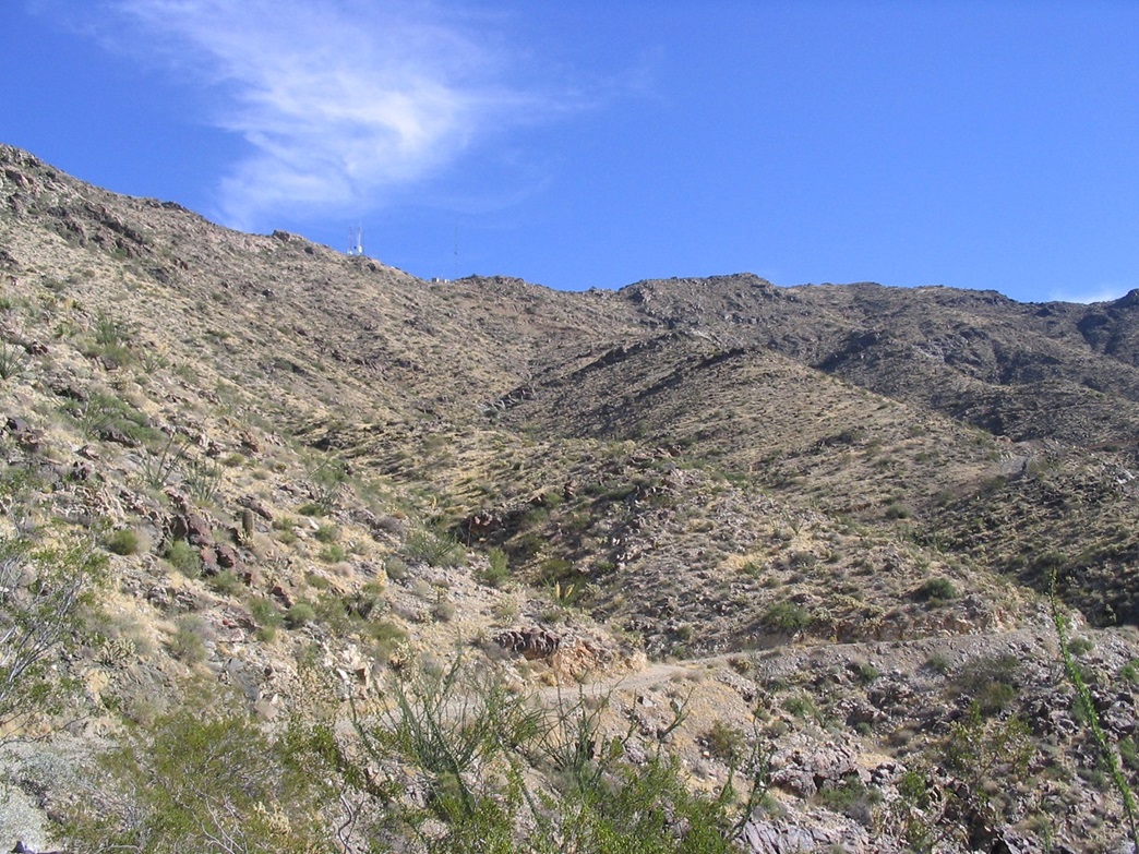
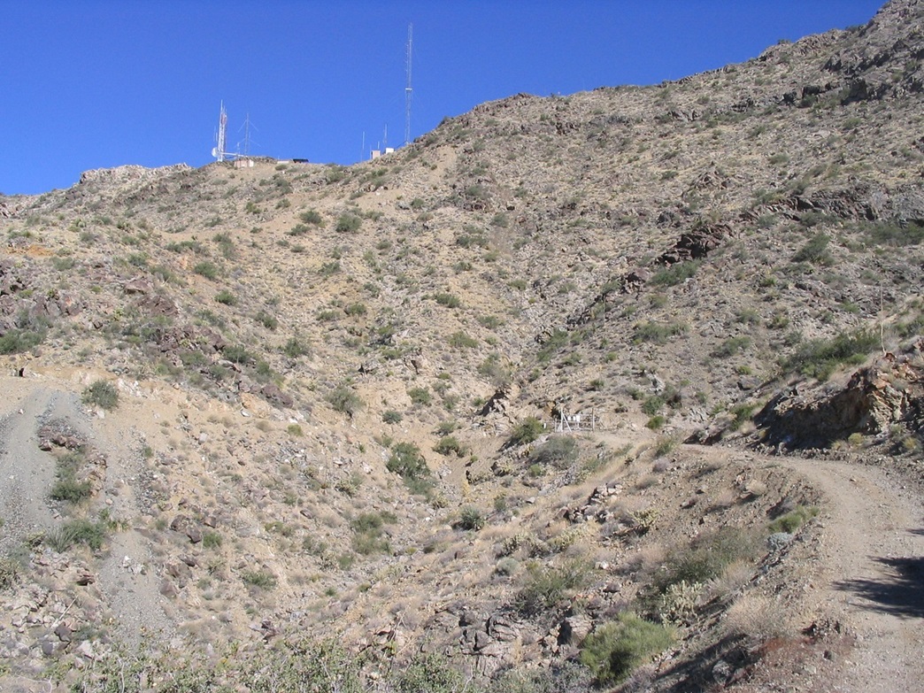
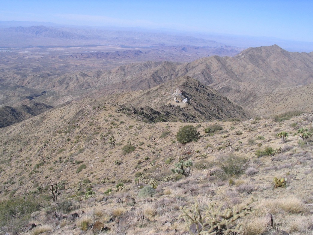
Past the gate, the road gains steeply, always visible ahead of me as a swath of discoloration on the desert slopes. I took a break after an hour, in which I had gained a thousand feet. After one of the many bends, I could finally see the tower complex on the west ridge of Crossman Peak, and the summit to right of the towers. The road started a series of switchbacks up to the towers, gaining steeply in some parts. A couple of old mine adits and tailing piles were here as well. I then came to another gate. This one had the usual signs about staying clear of the towers, warnings of high radio frequencies, and the penalties of breaking the law. Once again, I scooted past the gate and hiked to the towers. I went behind a couple buildings and started up the trail that continues to the top. Now exposed on the ridge, the breeze was heavy and cold.
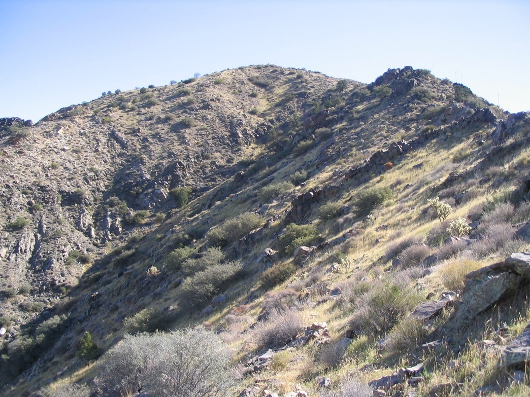
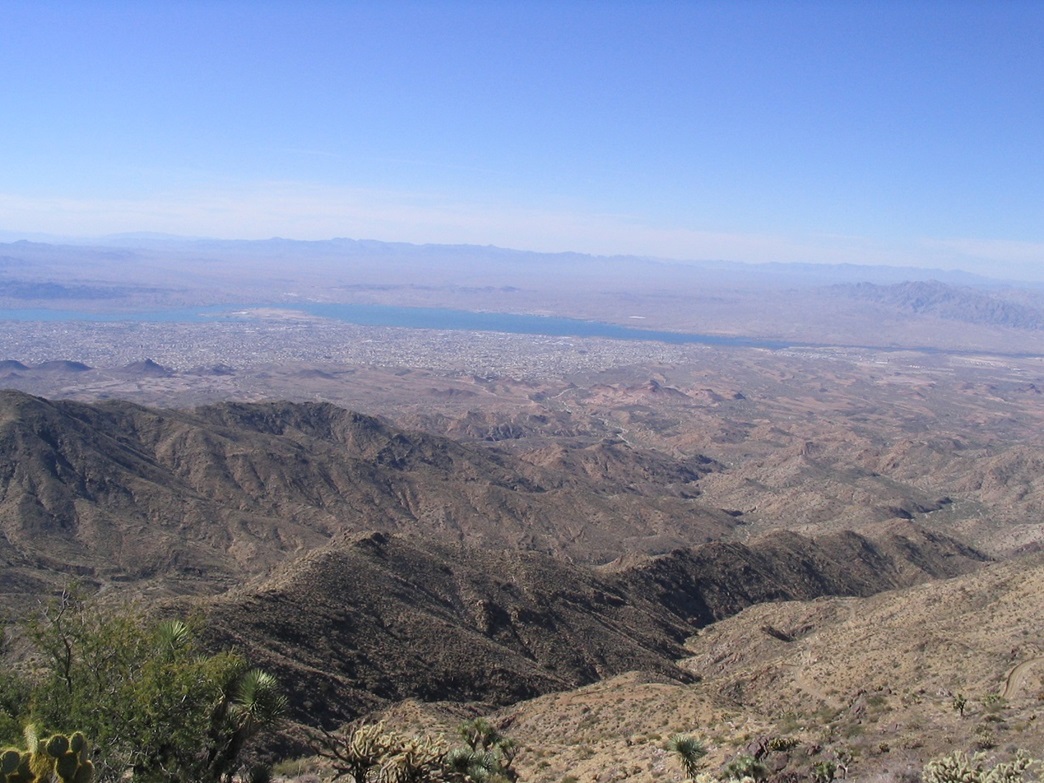
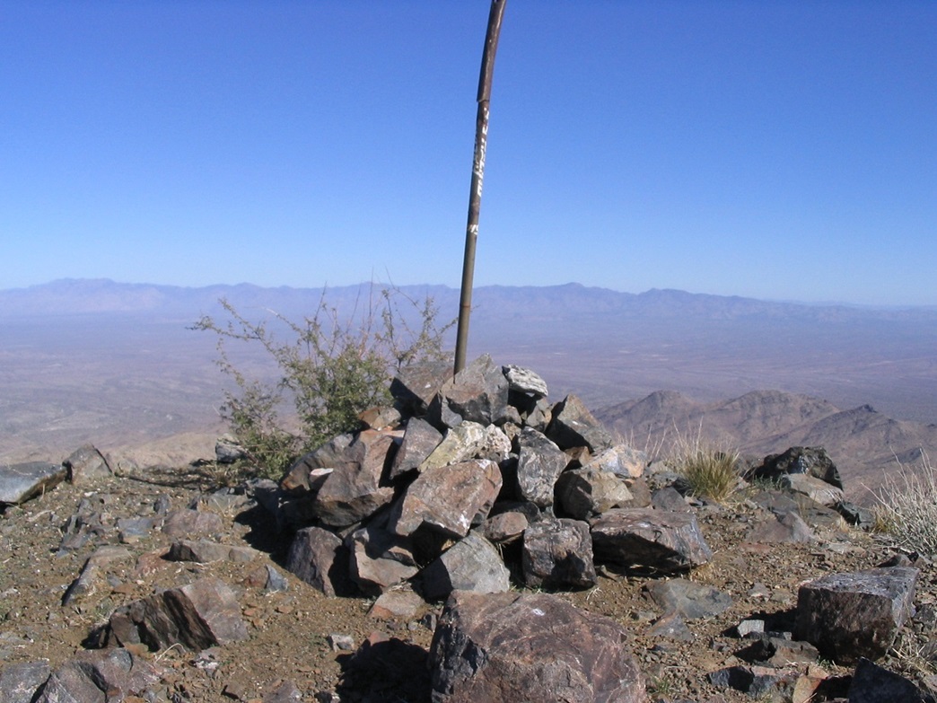
The final 400 feet to the summit is along this good trail, which gains towards a batch of rock outcrops. After a few of these, it lets out onto wider, more moderate slopes. At last, the trail came up and over a small hump and there was Crossman Peak, topped by a steel pole set in a large cairn. I scampered up to tag the top and look for a register (I found none). The views were astounding, but the wind forced me to descend a few feet onto the lee side to stay comfortable. It had taken me 2 hours to hike to the top. I had a full signal on my cell phone, so I called my wife to say hi. Lake Havasu City was visible below, set against the blue ribbon of the Colorado River. I could also see a lot of dust being kicked up by the breeze, and the beginnings of dust clouds. I spent 10 minutes on top, and it was noon when I started down. As pretty as everything was, the wind was too brisk for my comfort.
The hike down took exactly an hour, going at a good pace. The steep roads and rubble forced me to take some parts carefully. I landed on my butt once, and came close a few other times. Back down near the grave area, I came upon some off-roaders and we had a short friendly chat. Then it was back to the truck and the drive out. I picked up B. at the Starbucks and we spent the rest of the day driving home, highlighted by a dinner at Tonopah Joe's Truck Stop in Tonopah, west of Phoenix. We also managed to get snarled up in the traffic leaving PIR, after the yearly big NASCAR race. We exited the freeway and took a back-route home.

My court date was not until the following February. I took a day off from teaching and rented a car to drive to Parker. I didn't want to have my truck with me, in case they would run my plates again. The court was simple: the judge sat at one table, the officer and me at another. The officer spoke for the record, then it was my turn. My first bit of luck: the officer forgot to mention the other vehicle he had pulled over.
My main argument was how he could be certain I was going the speed he said I was going. What vehicle did the radar gun track? Could the gun show an erroneous reading by bouncing off between the other vehicle and my vehicle? But when he forgot to mention the other vehicle, I had my "in". When it was my turn, I kindly reminded the officer and the judge about this other vehicle. It would be on the record so there'd be no way he could deny it. The officer then got annoyed and tried to amend his statement, mentioning this other vehicle ... but the judge got annoyed at him, reminding him that he'd had his chance to speak for the record.
The officer was really worked up, clearly upset, and the judge started to question him exactly the same set of questions I intended to use. Sensing this may go my way, I shut up and let them go at it. Their back-and-forth lasted just a couple minutes. The judge felt that there was enough uncertainty and dismissed my ticket. I thanked everyone and got the hell out of Dodge. I drove 45 miles into Quartzsite, where I stopped for gas and called βð with the news.