
The Mountains of Arizona
• www.surgent.net
|
| Blackhawk Mine Peak • Peak 1570 |
• White Tank Mountains • City of Buckeye • Maricopa County |
|
Date: March 11, 2023
• Elevation: 1,570 feet
• Prominence: 400 feet
• Distance: 2 miles
• Time: 1 hour, 10 minutes
• Gain: 430 feet
• Conditions: Warm, dingy high clouds
Arizona
•
Main
•
PB
•
LoJ
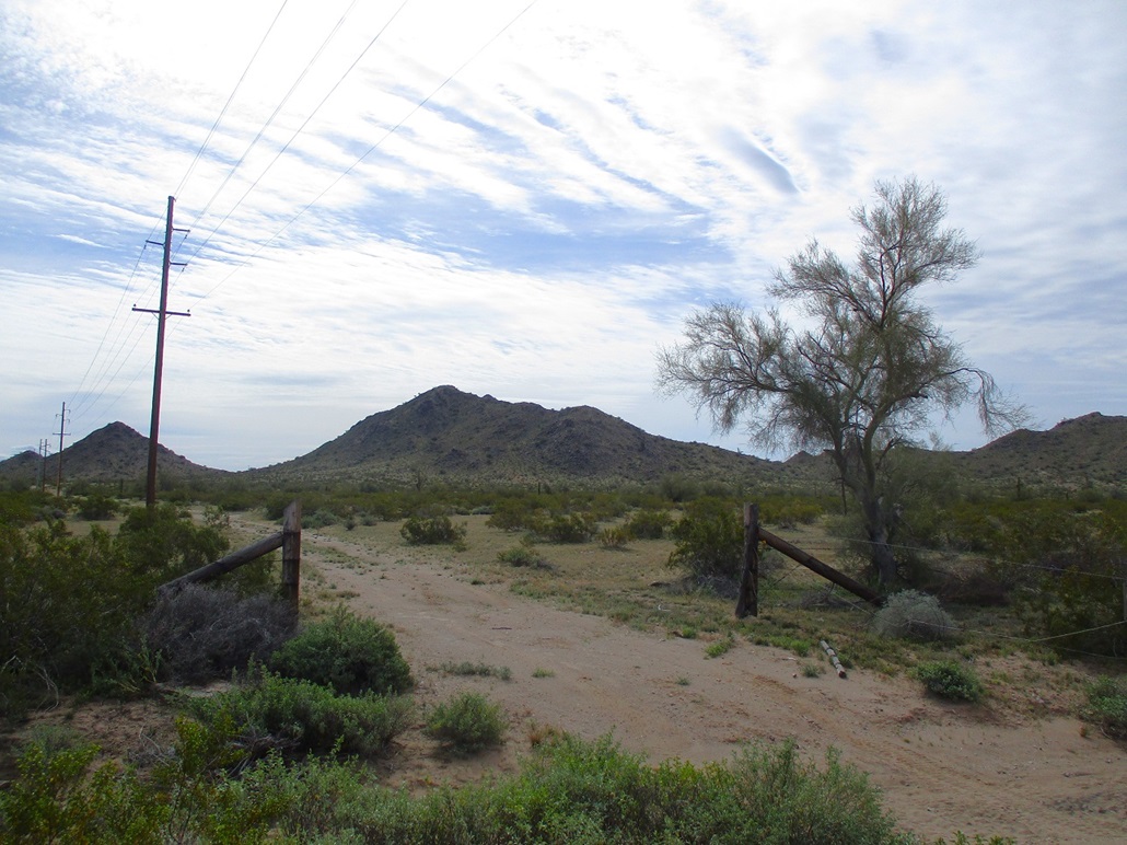
This is Peak 1570, or Blackhawk Mine Peak as I call it. On the hillsides and flats below are a handful of old mine shafts, some vertical, from what the maps call the Blackhawk Mines. This peak is the southernmost peak of the White Tank Mountains. It rises immediately north of the interchange where AZ-85 branches south from Interstate-10 in Buckeye. Thousands of people drive by it daily.
This was my only hike of the day, what ended up being a comedy of errors where all my initial plans fell apart. I was happy to get this little guy done and in the books, but it's not something I would have spent half a day driving to or from to do on its own merits. But, I'll take it. It's better than sitting in an apartment staring at the walls. Plus, the peak has some interesting personal history, which I'll get into momentarily.
My plan for today was to tag two or three, maybe four, singular peaks that I otherwise would ignore, thinking that combining them all into one outing would be a good way to get them all. I actually aimed for Gila Bend first. I was up early and on the road before dawn. I gassed and got drinks in "the Bend", then got onto Interstate-8 westbound, intending to hike Sentinel Peak, which is a volcanic vent/mound on the Sentinel-Arlington Volcanic Field. The peak rises gently from the surrounding lava beds and has been on my want list for awhile, but every time, I get stymied by the parking and access situation.
This is not my first look at Sentinel Peak. It rises a mile north of interstate-8, about 25 miles west of Gila Bend. But there just isn't any convenient access. There are no roads near it. The only feasible way to approach it is from the interstate itself, parking alongside it, then breaching the fence and running up to the peak. Otherwise, the closest roads get to about 3 miles from the peak. I'm not sure this peak is worth 6 miles of desert walking.
When southeast of the peak, I eased to the side of the interstate and studied the parking situation. Usually, there's about 50 feet of brushy frontage. But here, I couldn't get onto it at all. The margin between the gravel and the frontage was too brushy. My only option was to keep my car parked on the gravel shoulder. That was not an option I would consider. At one point, I got out to study the fence. It's barbed-wire but very sturdy and built in such a way to inhibit scootching under it. It looked essentially impassable. Forget it. I did not want this kind of nonsense. So once again, Sentinel Peak defeats me.
I drove to Sentinel Road, exited, got back on and headed back to Gila Bend. I had a back up plan. I was now looking at Nose Benchmark, a P1K north of the town, but I had no maps and was only going by what I read about on the web. I found Pierpont Road fine, but it was gated short of the peak's base. I wasn't expecting that. Next, I drove north to the Gillespie Truss Bridge. I was here a week ago and figured I could tag some of the peaks near where Enterprise Road branches off Old-US-80 near the bridge. The only two side tracks that get up onto the slopes I wanted were gated and posted. I wasn't willing to trespass or walk extra distances. So I cancelled this one. Admittedly, I wasn't enthusiastic about any of these and was backing off them the first inconvenience I encountered. It was nearly 10 a.m. by now, the sky a heavy gray, but the temperatures in the low 70s. It wasn't cool, it wasn't warm. It was a little sultry. At this point, I was ready to toss in the towel and go home.
I got onto highway AZ-85, heading north. Suddenly, it looked like a good opportunity to hike this peak. Even then, the gods were working against me. The connector to westbound Interstate-10 was closed, so I had to go east a little, then double back west. I didn't go far, exiting onto Sun Valley Parkway. I went north a little, overshot my turn, doubled back again (I set a world record for doubling back today), found McDowell Road, went east on it briefly. It curves south and connects to old Tonopah-Salome Road, which runs diagonally southeast-northwest. These days, it's a dirt road, not really open to traffic but no one checks. I followed it to a cattle grate and a sign saying no hunting, no hiking, no shooting, no everything. So I no enter. Staying on the safe side, I found a lesser track that went south to a fencline and power lines, and parked in a cleared area. Peak 1570/Blackhawk Mine Peak was not far, less than a mile to the southeast.
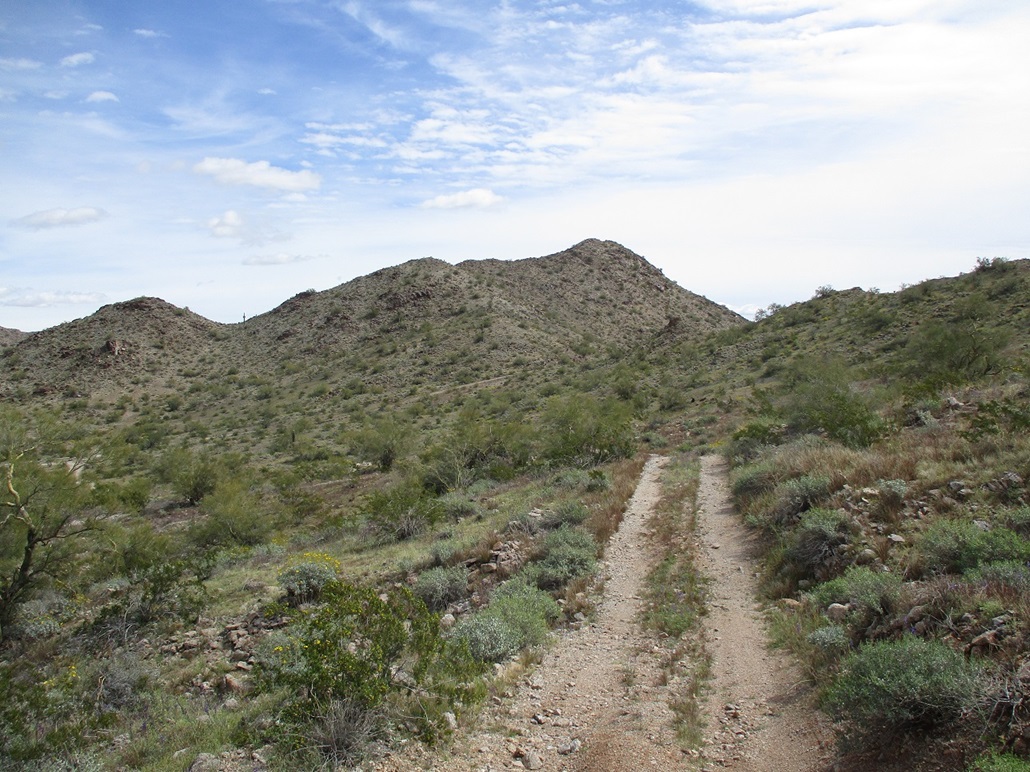
I started walking at 10:50, already warming up, but the sun was muted by some high cirrus clouds. It was warm but not uncomfortable. I aimed toward the peak and got there in a matter of minutes. I got up a few feet to where I could look down on the flats below me, a mush of tracks, piles of dirt, a few scattered pieces of junk, a visible mine shaft, and memories.
In 1998, as a member of the Maricopa Sheriff's Mountain Rescue team, we were asked to do an evidence recovery, and they needed us because it would involve lowering some guys into one of the shafts, and we had the expertise to do it. Before the actual recovery, a few of us drove out there in small groups and practiced rappelling. Using a bumper of one of our cars as an anchor, I and another guy rappelled into a mine shaft about a hundred feet. And then stood upon the back end of a vehicle. Someone was dumping them into the mine shaft. We'd be pulling this one out, and three more as I recall.
I do not like enclosed spaces and have no desire for caving and mine shafts. The few times I've done it, I get terribly anxious. But this was good practice, and I needed to get over my fear. We ascended using a jumar and an etrier for the feets. It's exhausting work. The whole time, a steady rain of fine dirt particles fell on us. I was glad to be out.
On the days of the evidence recovery, it was like a huge convention of people. The bad person of interest was wanted for a very heinous, well-known event that happened a few years earlier. I won't mention the particular event as it's still unsolved. Somehow, the authorities felt that there may be evidence in the mineshaft connecting this individual to the crime. So everyone who was important assembled out at this site. Our team was there, as were about a dozen Sheriff people. We had a crane operator on site. The media trucks were present. And about 30 or 40 people in nice suits and professional attire, men and women alike, just standing around. Some were Federales. If it has an acronym, someone from it was there that day. To see these people standing around dressed sharply in the desert in temperatures in the 90s, and likely that most of these people were not local to begin with, was a very odd juxtaposition.
Me, I was main-line guy, in charge of the lowering system, then when appropriate, re-rigging it to raise the guys out. They do not rappel in cases like this. Two would go in at a time, holding onto a big metal hook from the crane. We'd lower them in, then they'd spend a couple hours connecting the hooks to a vehicle so it could be pulled out. We'd raise them out, then the crane operator would pull out the vehicle and place it to the side. Again, to see a car come out of a hole is not something you see every day.
We were a team of three. We had an anchor and brake boss, and a rope boss, and me, the overall boss with the walkie-talkie. So we'd lower them in, lock off and tie off the rigging, then stand around with the important people. They were clearly bored and probably a little overheated. One of the guys hung out with me. He was important, as his badge was hung around his neck by a lanyard. He was totally into what we were doing, asking all sorts of questions. He was a real cool fellow.
When it came time to pull our guys out, we'd set up a ganged 5:1 system and stretch it out. One person can pull in on the rope, but it's more fun to have a whole bunch of people do it, so I asked if anyone wanted to volunteer and quite a few did, giving them something to do. All they needed to do was hold on to the rope and walk it toward our rope boss, drop it, and walk to the side. We did this a few times. As an aside, I asked my important friend if they knew who did this heinous criminal act, and he said yes, they did. They just couldn't tie him to it, enough to convict him.
Unfortunately, none of the cars we pulled out had any useful evidence. I'm not sure what we expected to see. Bodies? Who knows. This evidence search took up two days, and a few people camped there. I went back home for the night, because (a) I had a big kitty to feed and pet, and (b) it was still very warm at night and I knew I'd get some sleep at home. I even made the news. A photographer took an image of our rope system and my forearm was on the front page of the newspaper the next morning. And I was also seen in one of the news clips. The whole event was one big bizarro experience. The underlying reason was grim and not to be celebrated. People took it seriously. But it was quite a show. I've never been in anything like it, before or since.
And here I was, back here again, the first time in 25 years (that it's been 25 years blows my mind). It all looked familiar. I could locate where I stood with our rope system (within a thirty-foot radius). I remember a road snaking up one of the hillsides. I felt a deja vu. Of course, today, it was vacant.
Okay, that went long. As for the climb, I just got on the ridge, walked uphill, worked through a couple easy rock outcrops, and was on top quickly, about a thirty-minute hike covering under a mile. The top was nothing special. There was no register. Looking down, I could see the interstate and hear all the cars on it. The sun was still muted and it was still warm, which always means insects. I kept moving to mitigate them flying into my ear.
I descended to the flats and walked around. I found one of the mineshafts, now covered by a large metal grate. This may well be the very hole I rappelled into back in '98. I now intended to hike up a lower subpeak but didn't get very far. It was warm and I wasn't that interested, so I hiked back to my car, an 80-minute round trip hike. I "enjoyed" the visit, seeing it all again and thinking about that crazy weekend.
It was noon now. I had been screwing around now for 6 hours and had one peak to show for it. There weren't any others convenient to my location, and I had no desire to get back on Interstate-10 and head home. So I followed Sun Valley Parkway north as it curls around the White Tank Mountains. It connects to Bell Road, then to the Loop-303 freeway. I followed that to Lake Pleasant Drive and checked out a big park. It was real busy, hundreds of people. it had playgrounds, ball fields for the little leaguers, a dog park, ramadas and grills. It was huge. I pulled into a slot and relaxed. I studied the map. One peak of interest could be hiked from here but it'd be a long hike. Not today, though.
I bailed, got back on the freeway and drove home, arriving at 3. What a day. It was a lot of driving and gas for one small peak. Sometimes, it works out this way. But I was glad to hike this one peak and revisit the area. For those keeping score, this is my 676th ranked summit in Arizona. The square root of 676 is 26. That's very momentous. If AA represents the very first Arizona ranked peak (Camelback Peak in 1992), then this is peak ZZ.
|


|