The Mountains of Washington
www.surgent.net |
| Mount Rainier |
• Highpoint: State of Washington • Highpoint: Cascade Mountains & Pierce County • Most Prominent Mountain in Coterminous United States • Twenty-first Most Prominent Mountain on Earth |
|
Date: August 13-15, 1997
• Elevation: 14,411 feet
• Prominence: 13,246 feet
• Distance: 16 miles
• Time: 16 hours (summit day)
• Gain: 9,100 feet
• Conditions: Calm weather, blue skies
• Teammate: Vic
Main
•
PB
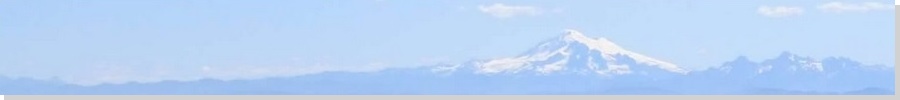
Prologue: Mount Rainier is the mountain of the northwest United States. Yes, I know that northwesterners can think of eighteen "better" mountains than Mount Rainier, but for a desert boy such as myself, who gets to Washington about once a decade, Mount Rainier represents everything what a grand, northwest peak should be. It is gigantic, looming nearly three miles into the sky when viewed from the base. It is mesmerizing and beautiful. Naturally, I had to climb it.
Around 1997, I started to think I was a real mountaineer, but had never climbed any big peaks with glaciers, nothing as daunting as big Rainier. I would concentrate my efforts this year on Oregon's Mount Hood, and Washington's Mount Rainier. So I trained, read books, and talked to whomever I could find who had climbed either peak. I spent six months psyching myself for these big peaks. I badly wanted to climb both.
First Attempt: In May 1997, when I had a break from teaching, I made the long journey to the Pacific Northwest and tried my luck with these big snowballs. For Mount Hood, I signed up with the Timberline Mountain Guides, aware that I was a novice when it came to glacier climbing. I also worked in dates to attempt Mount Rainier, teaming up with two college friends, Vic and J., now married and living near Seattle. Perhaps I was overly optimistic, trying for both summits on this one trip, but I thought it was worth the gamble. As they say, there's only one way to find out.
I was successful on Mount Hood, a thrilling experience for me. I came off that peak riding an emotional high, and from Portland, drove north to Seattle, staying a night with Vic and J. while we got our stuff in order for our Rainier climb.
We left their place on the morning of May 24th and drove to the Paradise Ranger Station parking lot. The weather was dreadful, with dense fog, gray skies and cold rain. On the road up the mountain, the snow was still piled high. The plows had thrown up "walls" of snow beside the roads about 15 feet high. It was like driving in a tunnel. We parked, suited up and started the hike around noon. Our goal today was Muir Camp, about 4,700 feet higher. Saddled with heavy packs, we entered onto the deep snow, then started the uphill grind. I was hating things after 15 minutes. I couldn't see 20 feet ahead of me, and everything was a gray phantasm in the fog. The snow was steep and mushy. I fell a lot. I was tired and spent, but somehow we made it to Muir Camp, arriving around 6 in the evening.
I was completely thrashed, and not at all up for a summit attempt the next day. The only saving grace of this ordeal was the final thousand feet, once we had ascended above the fog. The views of the upper mountain and of the surrounding hills and lower clouds was something I'll never forget. We set up camp, ate, and then crawled into our bags and slept, still working under the assumption we'd be starting our summit hike around midnight. So midnight comes and I'm awake, and Vic and J. are awake, and we look outside and see teams starting up, and other people milling about getting their act together. It's bitterly cold, the ground is hard ice, and there's a strong wind. When Vic expressed doubt, I could have hugged him. The three of us decided to abandon the attempt and sleep in. In fact, the teams that had left early that morning were coming back down too. No one was summitting today.
The hike down was long and grueling, but fun in a tiring, tedious, foggy, falling-down sort of way. The first couple thousand feet of descent down the Muir snowfield was interesting. One guy was skiing it. Occasionally we'd hear a big gunshot-type sound, realizing it was the nearby Nisqually glacier calving big seracs. You could see the cloud of pulverized snow lift up, like confectioner's sugar. Then, we hit that effing fog layer again, so for the remaining descent, we followed the wands or other people. The fog suppressed noise, and you never had any idea just where you were. I took a spill down a 20-foot slope at one point. Finally, we were among the trees again, and things were flattening out, and bam, the cars. You couldn't see them from 50 feet away.
I was grateful to be back to the cars, and that this ordeal was over. I had not enjoyed it at all, viewing it as a lesson in what this type of climbing really involves, and just how mentally difficult it can be. I was happy to have been successful on one of the two big peaks. I bid J. and Vic goodbye and started my long drive south through Oregon, California and on home to Phoenix.
Second Attempt & a Major Storm: Back in Phoenix, I looked into retrying Rainier in August, and Vic was game for another attempt. I think it bugged him we had to turn back in May, and he had not yet had success on Rainier on his other attempts. So we set up some dates in August for a re-attempt. J. would pass on this try. We actually set up a whole week, with one day to climb to Muir, a rest day to acclimate, three days to make the summit (allowing for bad weather days), and a day to hike down. We were getting up the darn thing one way or another!
This journey started in California. I had my cat with me and would leave him with my folks while I was gone. I usually cross the desert at night in the summer to avoid the high heat. I left Phoenix around 9 p.m. on a day that had been very active with monsoon thunderstorms. A big one had passed through town that evening, but had dissipated by the time I left. So I get about 50 miles out of town, around Buckeye-Tonopah on Interstate-10, and drive headlong into a gigantic thunderstorm. So it hadn't dissipated, it had just moved west. The rain was squall-like, the lighting every half-second and the claps of thunder unbelievably loud. This was a major-league storm.
In time I had driven past the rain cells into relative calm, then I hit dust. It quickly thickened to zero visibility. This was at the Vicksburg area on Interstate-10, about milepost 45. I am not kidding when I say I could not see my car hood. It was like a towel being placed over the windshield. I straddled the white lane lines then luckily saw a DPS cop with his lights, as he was slowing traffic down. I got in behind him then eased to the shoulder, actually driving well off to the side onto the sandy margin, and waited out the dust. What I had done was drive into the leading dust cloud (the "haboob") of this storm. These things move about 25 miles per hour. I let my cat out of his holder and he poked around the car, wondering what was up.
When the dust had cleared, I continued westward, hitting dust again in Quartzsite, about 30 miles later. By now it was 1 a.m., about two hours behind normal schedule. So I had to wait out the dust again for another hour, sitting there in my car with my cat in Quartzsite. I finally got moving again, only to hit the dust again west of Blythe. I was sensing a trend by now. So I waited it out again. I didn't roll into San Dimas until 5 a.m., about three hours behind schedule. I can't complain though. This was the same storm that caused a horrible flash flood in the slot canyons up near Page, where about 10 people drowned.
I spent a couple days in Southern California, then flew to Seattle to meet up with Vic for our Mount Rainier redux. We knew what not to do. For example, no starting at sea level and hoping to hike to the 10,000-foot Muir Camp the same day, like we did in May. We got food and goodies, then drove to Paradise and car-camped in his truck at the trailhead, giving us a night at 5,000 feet. This would help. The next morning we started early, mentally prepared for the long grind up to Muir Camp. But now, August, the snow line was 7,500 feet, so the first few miles was along paved and hard-pack trail with beautiful wildflowers and forest scenery surrounding us. There was no fog and the weather was mild.
We then encountered snow patches, then the snowfield itself. The remaining 2,500 vertical feet was up the Muir snowfield. The snow itself was compacted and pocked, making for good footing all the way up. I mentally zoned out, put one foot in front of the other, and grunted my way to Muir Camp, arriving about noon. I was happy to get that segment done, as I had not been looking forward to it. We thought about grabbing some bunks in the Climber's Hut, but it looked like a zoo, so we pitched a tent in the general area and prepared for the next day. We had decided to sit a day up here to acclimate to the elevation, but we also agreed that if the weather was as pretty tomorrow as it was today, we should take advantage of the opportunity, so we prepared under the assumption tomorrow was our first summit attempt.
The Climb: We both crawled into our bags around 4 in the afternoon, trying to sleep in spite of the people milling around in the daylight. We awoke at 10:30 p.m., got our stuff in order, and started up the mountain at midnight. The sky was black with millions of stars and a partial moon. There was enough ambient light to make the snow reflect a deep blue, discernible against the black of the sky. Headlamps weren't absolutely necessary, but we used them to make sure we were stepping on solid footing, not over a crevasse.
The first segment is a level traverse of the Cowlitz Glacier. This was easy and went well, leading us onto the Cathedral Rocks, which separates the Cowlitz Glacier from the Ingraham Glacier. We walked over the rocky terrain to surmount the crest of the rocks, then followed a good footpath that fed us onto the Ingraham Glacier. There was a team ahead of us, and looking back, more coming up from Muir Camp. We were not expecting to set speed records, hence our earlier start.
The path across the Ingraham Glacier was easy, too. Previous teams had beaten in a path about a foot deep in the snow, so we followed it up the glacier toward the base of the Disappointment Cleaver. This stretch covered about a half mile. Total, we'd covered a little over a mile, gained about a thousand feet, and were doing well. There had been a few small crevasses to hop over on the Ingraham Glacier, nothing big, or so we thought at the time (read on). At the base of the Disappointment Cleaver, we got our heads right for the next segment, the extremely steep grind up the Cleaver, arguably the crux of the whole climb. I actually bashed my head into an overhang at one point, happy to be wearing my helmet because I hit it hard. I have to admit, the darkness hid a lot of things from my eyes. Had I actually seen what we were about to do, I think I would have had a small anxiety attack. But in the dark, we just concentrated on the next patch of ground, and did that all the way upwards.
The "trail" up the Cleaver was a path beaten into the snow. It switchbacked left and right over and over again, too many times to count. Some of the faster teams were passing us including teams from the guided service, RMI. I remember thinking that it was good I couldn't see much here. I could sense a lot of slope and a lot of air. But happily, we finally arrived onto the top of the Cleaver, where the path levels ever so briefly. An RMI guide told us (and anyone who was listening) that we were at 12,400 feet. It was about 4 in the morning, with dawn barely breaking to the east. It was incredibly magnificent, to see the sun's light peak over the horizon, spread over the few clouds below, lighting up the land and the upper mountain. We could see things now, such as Little Tahoma, the big tooth-like pillar-summit that is a notable landmark near the Ingraham Glacier.
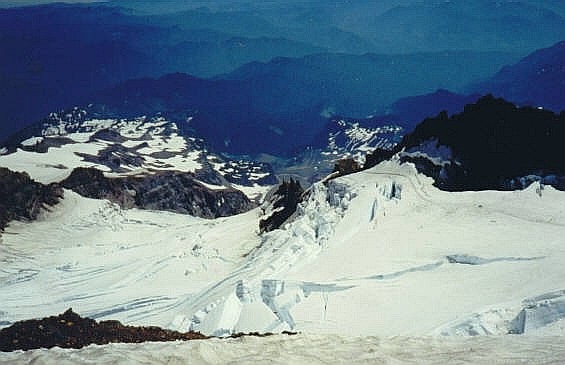
We still had 2,000 vertical feet to climb. I was huffing and puffing, feeling the effects of the thin air. We'd walk a dozen steps, then catch our breath, and repeat. The climbing here was not as severely steep or intimidating as below, but it was remarkable. We would cross alongside edges of crevasses hundreds of feet deep. The glaciers would be broken into wildly amazing (and large) blocks of ice and serac pillars. It all had a deep blue color, and deeper down, pitch black. It was beautiful, and humbling. It reminded us to pay attention, and make no wrong steps. It was like being on an alien world.
By now, the faster teams had long-since passed us, but we were in a (slow) rhythm, and in time we had got in behind a team going about the same speed as us. They were about 200 feet ahead of us. They would round a bend or crest a ridge, and disappear from us until we came to that bend or ridge, at which time we'd see them for just a moment before they disappeared on us again. This cat-and-mouse game worked well as it gave my mind something to think about, and we did this for about an hour.
This team crested another ridge, and we came to that ridge a few minutes later, but they were nowhere to be seen. Where were they? Where's the rest of the mountain? What are those rocks up ahead? Holy smokes, we're here! I had not immediately picked up on the fact that we were now approaching the summit caldera. We had made it! I saw some guy crawl up the rocks, take off his jacket and relax, and I was thrilled. This was it, the summit.
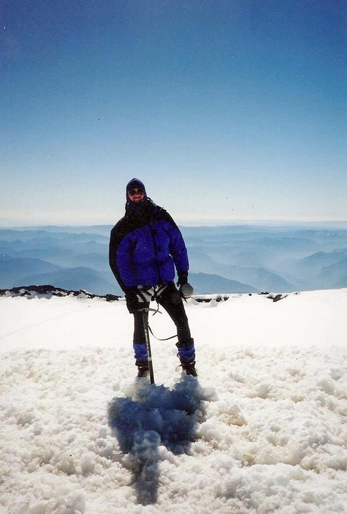
We clambered over these rocks and descended about 20 feet, now sitting on the level snow of the inner caldera. There were a few dozen people scattered about, most clumped near our position. Many were from the RMI groups. People were standing around, talking, shooting photographs, lollygagging, enjoying their time up top. For us, the climbing was not yet finished. Whereas RMI brings its groups to the summit caldera, the actual highpoint is a hill across the caldera called Columbia Crest. It's not a little bump, but a 200-foot high hill. As far as I was concerned, we hadn't yet "climbed" Mount Rainier until we'd stood atop the hill.
The walk across the caldera was easy, and so was the hike up the hill, which, interestingly, was free of snow in spots. We took photographs and returned back to where everyone else was. It was interesting to note how few people actually climbed Columbia Crest. Most people are happy just to be at the caldera. I probably wouldn't dicker over small details, but Columbia Crest is not trivial. It's 200 extra feet. Some people, especially on guided teams, discover that they aren't allowed to climb this hill. I know this bothers some people. It would me.
We had arrived at the caldera about 7:30 in the morning and spent nearly 90 minutes up here. We let some of the guided teams start down first, and then we followed. The weather was clear, cloudless and warm, about 30 degrees here at the caldera. The descent down to the top of the Cleaver was easy, but we watched every step. The snow was getting mushier. In an hour, we were back to the Cleaver. This part had been weighing on my mind all day, and I wanted down from it, the sooner the better.
We followed the snow path as it started to steepen, then seemingly go over the edge. In reality, it starts down the main slope of the Cleaver, which is close to a 40% gradient. It would be real easy to look out over all what lies below and freak out, so I made it a point not to. I just looked at the patch of mushy snow about 2 feet ahead of me, and made triple-sure my crampons were solidly set, before repeating this process. When the footing was less secure, I sat on my ass and governed my slow descent with my boots. Mind you, this was no glissade. Literally, I would scootch my butt forward, extend the legs, and do it again. It was terrible to watch, but effective. In this way I inched down the Cleaver. Vic was ahead of me a few yards, and we reconvened when the snow slope gave away to the rocks below the Cleaver. Whew! What a wonderful sense of relief. I knew the remaining hike back to Muir Camp would be easy, and for the first time on the whole journey, I was actually enjoying myself.
The hike down the Ingraham Glacier was interesting as we could see the huge gaping crevasses we had not seen in the darkness on the ascent. There were seracs about 100 feet high, slits in the snow about a foot wide opening up into great voids below. And we had been walking amid these things a few hours earlier, oblivious to it all. We got back to the Cathedral Rocks, then had to make the last traverse across the Cowlitz Glacier. By now, with the warmer temperatures, rocks were being released from the glacier's icy hold, and rumbling down the slope like bowling balls. We unroped and literally ran this segment. I was so bushed when we arrived back at camp that at one point, I stumbled a few feet from our tent, and fell fast asleep in position. At the tent, I immediately crawled into my bag for a three-hour nap. When I awoke, it was about 5 in the afternoon. A lot of the summit teams had already started down the mountain for the parking lot, but we were staying put for another night.
We made dinner and lazed around the camp. A whole new set of climbers had arrived for their date with Mount Rainier, and we were like rock stars, everyone asking us about conditions, what was it like, that sort of thing. I could feel their sense of excitement and trepidation, the same feeling I had had the previous day. I sincerely wished every one of them the best of luck. I also spent time walking around the area and looking out over the landscape, with cloudless views everywhere. Other big volcanoes stood grandly in various directions (Mount Adams, Mount St. Helens and Mount Hood, with Mount Jefferson sort-of visible way to the south). The sunset was something else.
The following morning's hike down went well. We hit a little fog on the way down, but nothing to concern us. We were back out to Vic's truck by 10 a.m. The final mile along the paved nature paths was amusing, us lugging big packs, looking like hell after all what we'd done, ambling past the day-hikers out looking at the flowers. Vic developed blisters and had to go slow, so I waited for him back at the truck. We changed, cleaned up, got some burgers and rode back into Seattle that afternoon, where J. was quite surprised to see us back so soon. I stayed an extra day with them until my flight out.
Epilogue: I cannot thank Vic and J. enough for their camaraderie on the mountain, for both the May and August attempts. Climbing Mount Rainier was at the time (and continues to be) one of my all-time great life thrills. I treated them to a celebratory dinner, then ran into a mishap flying home when I couldn't find my driver's license to prove who I was at the airport. They had me sign all sorts of affidavits but finally let me on board. The flight out was fun, since I could stare down at the giant mountain and say, "I was there a couple days ago". Even today, I still wonder how I got up and down the mountain. It was a singular thrill and an amazing experience.
A few weeks later, back home in Phoenix, I got a letter from RMI with my driver's license inside it. It had fallen out at the summit, and was picked up by an RMI guide. I also lost a couple items, like a rappel device and a couple carabiners. I guess I had a zipper open because I lost all these things at once.
|


|