
The Mountains of Oregon
• www.surgent.net
|
| Mount Hood |
• Highpoint: State of Oregon • Highpoint: Clackamas and Hood River Counties • Mount Hood National Forest & Wilderness • Cascade Mountains |
|
Date: May 22, 1997
• Elevation: 11,239 feet
• Prominence: 7,706 feet
• Distance: 6 miles
• Time: 8 hours
• Gain: 4,320 feet
• Conditions: Clear and cold, then colder, then clouds moved in as we descended
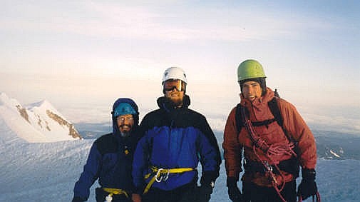
• Teammates: Kirby (guide) and Jim
Main
•
PB
•
LoJ
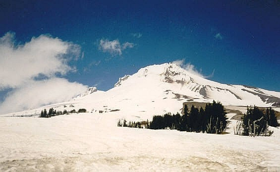
Mount Hood is the highest peak in Oregon, rising about 70 miles east of Portland. It is an active volcano and one of the peaks that compose the Cascade Mountains that stretch from Washington to California. My initial interest in climbing Mount Hood was for its status as the state’s highpoint, but in the bigger picture, it served as motivation for me to climb a glaciated, snow-bound mountain, something I had never done before.
I spent many months prior to this trip researching the climb, reading anything I could get my hands on, talking to people, and even trying out the newfangled “internet” for possible reports. Knowing I was a complete novice on steep-angle snow mountaineering as well as the basics of ropecraft, knots, self-arrest and so on, I chose to sign up with the Timberline Mountain Guides and go with their expertise.
I had time off after the semester ended at ASU, so I split the drive to Mount Hood over four days, spending time in SoCal with family, the Bay Area in Northern California with college friends, a night in Klamath Falls, and finally, arriving in the town of Government Camp, at the base of Mount Hood, on the afternoon of the 20th. The next day, I drove to the Timberline Lodge and met my guide, Kirby, and the other member of the climb, Jim the Doctor. We spent the afternoon learning some basics of roped travel, tying knots, self-arrest, and other skills. Although it was an abbreviated course, I felt better knowing at least some skills. I spent that night at the climber’s hostel at the Timberline Lodge. I was lucky and had a room to myself.
We were to meet at 2 a.m., so I was out of bed by 1 a.m., packed, ready and excited. I met Jim outside the lodge. It was cold but not uncomfortably so. There was a partial moon out tonight and the sky was clear. There was one other team out there, too, about seven of us total. After many months of looking forward to the climb, it was now “go” time! I was very excited.
We piled into a snowcat, which ferried us up past the ski slopes. It was a cramped, loud and unpleasant ride. A few climbers were out already, trudging up these slopes. I felt kind of guilty about being in a snowcat, but it only cut off a small portion of the uphill gain. We’d still be responsible for the bulk of the climbing. After about 90 minutes, we were let out at the highest of the ski-lifts. Higher up, it was noticeably colder, but still, not terribly so. I figured the air temperatue was about 20 degrees Fahrenheit. It was cold enough to create an icy sheen over the snow, but not so cold that it made everything completely iced. In other words, when we stepped, we could feel the crunch of ice, but then the softer snow underneath.
The other team got situated and started up the slopes, and so did Jim, Kirby and I. We were unroped, and we simply marched up the lenient slopes, following well-beaten broad paths that myriads of previous climbers had put in during the previous few weeks. This segment was very easy, and we covered about two miles and gained about 2,000 feet in a couple hours. We arrived at the top of the slope just as dawn broke. We were now on a snowy ridge called the Hogsback. We took a break here while Kirby unraveled the rope. From here on up, we’d travel as a roped team.
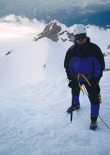
Above the Hogsback was a large bergschrund, a crevasse formed where the main glacier mass moves away from the actual mountain. Above the bergschrund, the slopes became much steeper and icier, and not surprisingly, much more treacherous. There were a number of teams up here, probably 30 people total. I was surprised that we were actually one of the faster-moving teams. Kirby tied us in and we started up, aiming for the bergschrund. Kirby led, then Jim, and me last.
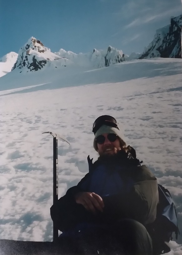
We arrived at the lip of the bergschrund shortly. I deliberately did not look into it, but even peripherally, I could sense its scale and depth, and the implicit understanding that falling in was not an option. To get across it, we had to move about 15 feet horizontally and gain about 10 feet vertically, just enough to require the ice-axe and a front-point with the crampons to get up above the big chasm. For a moment there, I felt like a real mountaineer!
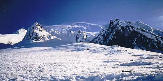
Now above the bergschrund, the slope was steeper as expected, about a 35% gradient. We were able to follow very scant paths from previous climbers, and after a couple-hundred more feet of gain, had arrived to the Pearly Gates, a ramp of snow situated between two rocky ramparts covered in rime ice, hence the name. It was indescribably beautiful up here. The snow and terrain was utterly alien to me, and the whole place reeked of sulphur. There were steam vents and places where there was no snow. It was a reminder that Mount Hood is still an active volcano and is still warm in places.
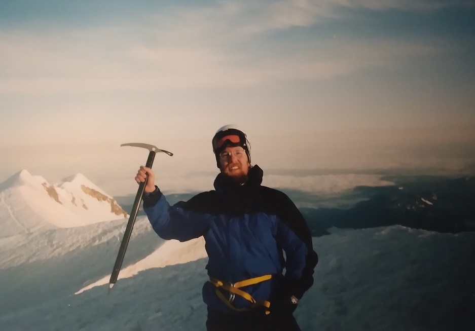
At the Pearly Gates, the slope moderated, and shortly, we were on the summit of Mount Hood! We arrived at 6:45 a.m., the sun still low in the East but lighting the whole place in a very beautiful, soft manner. The big stratovolcanos such as Adams, Jefferson and Rainier were visible. It was clear and a little breezy up here. At this elevation, it was quite cold. There was one solo climber up with us. We stayed up top for 15 minutes for photos and a rest, but given the cold and the fact there were more people to follow us, the sooner we got moving, the better. I had no objections.
We descended exactly the way we came up. We stayed in the same relative positions on the rope, but now I “led”, going downslope, with Jim behind and Kirby taking the top-most position. I made it my immediate life’s goal for the next hour or so to not slip or fall. I did not look down the steep slope and let it intimidate me. I just looked at the patch of snow in front of me and made triple-damn-sure my crampons were set solid before putting weight on it. In this manner, we slowly, but safely, made it down below the bergschrund. Kirby then made the call to the other teams that this section may best be avoided. Many teams were still going up, and they were now going the “long” way around the opening.
Below the bergschrund and back at the Hogsback, we rested and unroped. All we had ahead of us was our descent back to the Lodge. We braided out a little as we descended the snow slopes back to the ski runs, reconvening at the point where we were let out of the snowcats a few hours earlier. We then walked as a team down the ski slopes to the Lodge, arriving just before 10 a.m. In fact, they were closing the dining room from its breakfast service, but we got in just before and were able to score a hearty celebratory meal.
We took our time to enjoy breakfast and bask in the good vibes of a safe, successful climb. I was tired and thrilled. After eating, Kirby went on his way back to the guide hut. Jim had a room here at the hotel and he was nice enough to allow me to shower and clean up. We then met for some beers, sitting at one of the big windows and staring up at the mighty mountain, knowing that just a few hours ago, we were all the way up at the tippy top.
By midafternoon, Mount Hood started to disappear on us as some low clouds moved in. I felt it wise to say my goodbyes to Jim and thank him for his camaraderie on the climb. He was a good fellow and I was glad to have met him. I stopped in at the guide hut and said goodbye to Kirby plus gave him an honorarium for his leadership skills.
My whole trip could have ended here, but I had already made plans to drive up to the Seattle area and meet with two college pals, Vic and Joelle, now married. We were going to attempt to climb Mount Rainier in a few days. That climb attempt turned out to be a horrendous death march up snowy fog, but a valuable learning experience. Once off of Rainier, I split the drive to SoCal over two days, with one night in Cottage Grove, Oregon, then a 900-mile marathoner to San Dimas, California. After a couple of rest days, I returned to Arizona.
|
|