The County Highpoints of Texas
www.surgent.net |
| Del Venado Ranch Hills |
• Highpoints: Concho & Menard Counties • Edwards Plateau |
|
Date: March 16, 2003
• Elevation: 2,413 feet (Concho HP) & 2,432 feet (Menard HP)
• Prominence: 62 feet (Menard HP)
• Distance: 6 miles
• Time: 3 hours
• Gain: 300 feet
• Conditions: Clear and pleasant
Texas
•
PB (Concho County)
•
PB (Menard County)
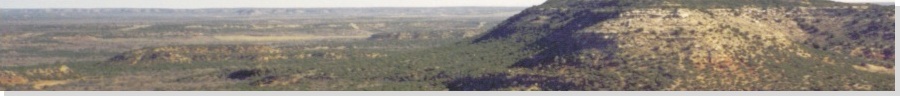
The highpoints of Concho and Menard Counties lie on a low, sprawling hill whose top lies within Menard County, with ridges north into Concho County. There are two 2,430-foot contours within Menard County, one with a spot elevation of 2,432 feet. One area in Concho County has a spot elevation of 2,413 feet.
My hike starts at a radio tower than can be seen from many miles. I tried a few ways to get there, arriving to it via local paved and dirt roads from the town of Eden. I arrived at 3 p.m., the weather pleasant and stable. The highpoints were about 2.5 miles west of this tower.
I almost didn't get anywhere at all. When I hopped the fence, I landed on rocks on the other side and almost busted my ankle. I took a few moments to walk it off and make sure it was okay. Satisfied that it was, I started the walk west. I was aiming for the Concho County highpoints first, two ridges off to the west.
The first Concho County highpoint area is a mile west of the tower, and the second area another mile farther west. The first three-quarters mile of the hike was through moderate tree cover, not enough to slow me, but enough to limit my line-of-sight views. I came to a fence line at 0.8 mile, shown on the map. This proved to be tricky to scale as all the posts were flimsy. Cattle watched me. I just put my head down and walked right past them. The land was more open here.
Soon, I reached the first area, the largest area and the one with the 2,413 spot elevation. I took a GPS reading to ensure my position, and I walked in looping arcs to cover this area. The "fattest" part of the 2,410-foot contour coincides with the spot elevation and I found this with no problem. Satisfied, I continued west toward a second fence. I could see the second Concho County highpoint ridge ahead.
Here, I noticed a work truck and a trailer up on the hilly area south of me. I was about a half-mile north and unless they were looking hard, I wasn't noticeable, even in the open terrain. As I approached this second fence, I noticed a herd of sheep. Sure enough, they all freaked out when they saw me, and took off running to the north. The sheep creating all sorts of commotion, I decided to spend the next few minutes laying low, hiding in a patch of brushy trees.
I decided to work up the courage and go meet and greet whoever was in this trailer. As I walked up toward them, the lay of the land was such that I became more hidden as a result. They were up on a hill, while I was below, hidden by the slopes. So I decided to skip meeting them and continued west.
I hopped a second fence, and entered into a copse of trees. I reached the second Concho County highpoint ridge quickly. No one area stands out as "highest", but I walked the spine as best as I could. I was north of the two Menard County highpoint areas, one of which I could see about three-quarters mile to the south.
So I continued on toward the Menard County highpoints. I came to a third fence running east-west. The map shows this fence to be inside Menard County by about 1,000 feet, and my GPS reading confirmed this. The fence makes getting the northern of the two Menard highpoint areas easy, as it runs over the top. I quickly ran over to visit this northern area, then hopped the fence to seek out the (likely) higher southern area, with the 2,432-foot spot elevation.
After lengthy walking through intermittent trees, I came to what appeared to me to be the highest ground. It clearly dropped to the south, west and north, so I paced east a little to cover the general area encompassed by the 2,430-foot contour. While I couldn't declare what particular rock was the highest point, I spent about 15 minutes walking the area, confirming with my GPS and visually, and left feeling confident I had been in the right place. Cattle were in the area, which was a little more open with less trees.
Satisfied I had visited the four necessary areas to claim Concho and Menard Counties, I began the long walk out, following my route exactly, including hopping the fences at the same places. The sheep were long gone, and the cattle had moved to go feed, too. I walked briskly, but I slowed down at the eastern Concho County highpoint area to walk the other fat part a little more as insurance.
I was back to my truck at 6 p.m., and it was getting dusky as I came back out to pavement and civilization. This hike entailed almost 6 miles round trip hiking, plus a gross cumulative gain of nearly 300 feet, when I include all my gains and drops. It was a pretty area with lots of green, trees, and rolling hills. I was expecting more ugly scrub but was thankful I had very little of that. The map was absolutely vital, and it helped that the main fences shown on the map were in their proper places in the field. A windmill roughly in the center of all this also served as a useful navigation reference.
This was it for hiking for today. I stayed in the town of Ballinger, putting me near Moro Mountain for the next morning.
|
|