The Mountains of Nevada
• www.surgent.net
|
| Mount Charleston |
• Highpoint: Spring Mountains • Highpoint: Clark County • Toiyabe National Forest • Most Prominent Mountain in Nevada |
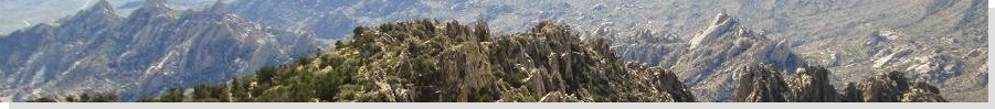
 The summit up ahead
|
Date: November 27, 1999
• Elevation: 11,916 feet
• Prominence: 8,241 feet
• Distance: 16 miles
• Time: 10 hours
• Gain: 4,270 feet
• Conditions: Very mild and comfortable
Nevada
•
PB
Mount Charleston is the highest peak in Southern Nevada, dominating the western skyline of Las Vegas. Its summit is about 10,000 feet higher the famous Strip. From below, a blocky massif called Mummy Mountain seems to be highest. The actual highpoint is the first point to the left (south).
I flew in to celebrate Thanksgiving with my parents, now living in Henderson. I packed my hiking boots and basic cold-weather gear for a possible hike for the day aftert the big meal. The weather had been very mild throughout the southwest. If it held a few more days, I could conceivably hike a near-12,000-foot peak much later in the season than normal.
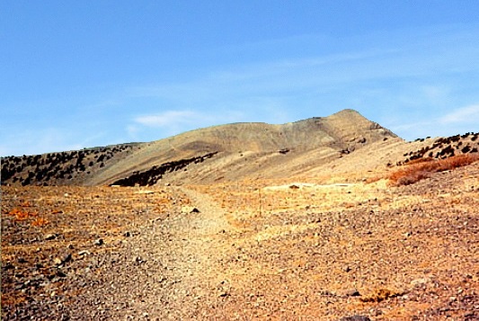
Early that friday morning, I borrowed one of my parents' cars and drove about 60 miles into the Mount Charleston town and ski area, arriving at 7 a.m. in cool but pleasant conditions. The peak can be reached by a loop with two possible trailheads. However, on this day only the southern trailhead was open. I parked at the Mazie Canyon Trailhead, the only car in the small lot.
The trail does not waste time going uphill. The grades are consistent but never steep, and the trail itself was in great shape. I seemed to be the only one hiking so far. The trail switchbacks up the steeper slopes and traverses an avalanche gully before curling around and levelling off near Echo Point, above a massive stone cliff about a thousand feet higher from the trailhead.
Continuing upward, the trail enters into thick pine and aspen forest and charges up a steep ridge, making well over two dozen switchbacks to lessen the gradient. This segment was a chore, but it gained elevation quickly. In about 90 minutes, I had gained another two-thousand feet to put me on the highest ridges of the range. I had hiked about four miles thus far, and the weather was chillier but calm, no clouds or wind to battle. I took my first break here and ate a snack: a turkey sandwich.
I was about halfway to the summit milewise, but had gained nearly three-quarters of the elevation. I was now a little over 11,000 feet and effectively at treeline, with no big trees up this high, just little scrubby plants. With the sun higher, temperatures warmed into the 50s. I hiked generally northwest on the trail, and was even joined by a hiker who had come up while I was taking my break. We hiked together for a couple miles.
Up this high, I had unobstructed views. The summit was still a couple miles away, a skewed point rising above the treeless ridges. To my left and a couple vertical miles down was the Amargosa Valley and the ghastly town of Pahrump sprawling out across the desert. My hiking pal started to slow and stumble, stopping often. We took a few breaks, and I suggested he may want to start heading down. He may have had a touch of altitude sickness. He agreed and started down.
I had about a mile to go, now high above any sort of vegetation. The trail crossed a couple long scree slopes and even the wreckage of an old aircraft. I was now on the home stretch, the final couple-hundred feet to the top when another hiker hustled up behind me. He was moving quickly, and we summitted the peak together, arriving at noon.
The one-way hike covered 8.3 miles (going by the forest literature), with about 4,270 feet of elevation gain. The weather could not have been better. It was mild, calm and clear, and we spent about a half-hour up here. I called my folks on my newfangled cell phone. A few moments later, another hiker showed up. Suddenly, the peak was very popular.
I started down at 12:30, following the same route back. I moved at a consistent and slightly slow pace due to a funny ankle that turned on me a few times. I didn't think about much except for putting one foot in front of the other. When I was back on the steep slopes in the trees, I met a few others and asked them about my hiking pal, the one who had to turn back. They said they saw him, so that was good to know he was making his way down okay.
The other hikers passed me at various times, and by the time I was down below Echo Point, I was the only person on the trails and it was getting late in the day. The sun was low to the west and everything here was shaded and noticeably colder.
I arrived back to my vehicle about 5 p.m., sore but feeling fantastic. This had been a long, strenuous hike and to this point in my life, the longest hike I had ever done in one day. I changed into more comfortable clothes and drove back to Henderson, arriving a couple hours later.
Mount Chalreston was my second peak hike in Nevada, coming over four years after I had hiked the state highpoint, Boundary Peak. Over the ensuing years, I would return to Nevada often to hike its peaks. But even so many years later, Mount Charleston still ranks as one of my favorites in the state.
|

|