The Mountains of New Mexico
www.surgent.net |
| Santa Fe Baldy |
• Highpoint: Santa Fe County • Sangre de Cristo Mountains • Santa Fe National Forest • Pecos Wilderness |
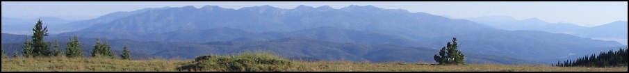
 Our first view of the grand peak
|
Date: October 9, 2004
• Elevation: 12,635 feet (Lidar)
• Prominence: 2,003 feet (Lidar)
• Distance: 14 miles
• Time: 8 hours and 15 minutes
• Gain: 3,600 feet
• Conditions: Clear, blue skies and cold
New Mexico
•
PB
•
LoJ
Santa Fe Baldy is the highest point in Santa Fe County, and if successful, this would be the last of the 33 county highpoints in New Mexico for me. It is a well-known peak in a beautiful part of the state, so it was by design that I "saved" this peak for last, to hike it with βð.
I was down to just three county highpoints, so about a month ahead of time, we made plans to come to Santa Fe and hike Santa Fe Baldy. In the meantime, I made separate plans to come to New Mexico and climb the other two county highpoints, Caballo Mountain in Los Alamos County, and Redondo Peak in Sandoval County. However, Redondo Peak sits on "closed" land and success was by no means guaranteed. But a little bit of luck came my way and I was able to climb both these other peaks two weeks earlier.
We arrived into Albuquerque on Friday the 8th, during the big hot-air balloon festival that is famous world-wide. What that meant for us was lots of traffic and an extremely pricey rental vehicle. We drove north on Interstate-25 then stopped, for about an hour. We just sat there on the interstate, not moving. In the meantime, we watched fireworks that were part of the balloon festival. It was dark by now so the balloons were grounded.
We saw cars bailing onto the median and onto the southbound lanes, but then traffic started to crawl. It turns out there had been a bad wreck in the southbound lanes, but that did not explain why the northbound lanes were closed too. We never really got a clear answer. We arrived in Santa Fe kind of late, had a late meal and then got to our hotel at 10:30 p.m.
The next morning, we were out the door by 7 a.m. and ran a couple quick errands before setting out for the hike. I had lost my sunglasses on the plane, so I needed a new pair. Then, I realized I forgot my jacket, so we went back to the hotel room. Then, back on the roads again, I had this feeling I had forgotten something else. My hiking boots! We had to return again to fetch them. My mind was definitely not in the moment. Finally, we could get moving.
So, finally organized, we drove twenty miles to the Santa Fe Ski Area, enjoying the colorful fall colors, and arrived at the trailhead about 8:30 a.m. in cool, clear weather. We got ready and were on the move by 8:40. The Windsor Trail (#254) is well-marked and well tended, its starting elevation being 10,260 feet. We both grunted up this first segment, a half-mile stretch in which we gained 600 feet. Shortly, we came to the top of the ridge and the boundary fence of the Pecos Wilderness, where we took a break.
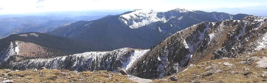
The next segment involves a long gentle descent of about 600 feet over a couple miles. The trail cuts east along the north face of the ridge in thick spruce and aspen (which were bright yellow with fall colors). Patches of ice and hail from recent storms covered the trail. Views were minimal and blocked by the heavy forest. We came to the junction with the Nambe Lake Trail after about 2.25 miles, then descended more to a small meadow opening where we could see Santa Fe Baldy for the first time.
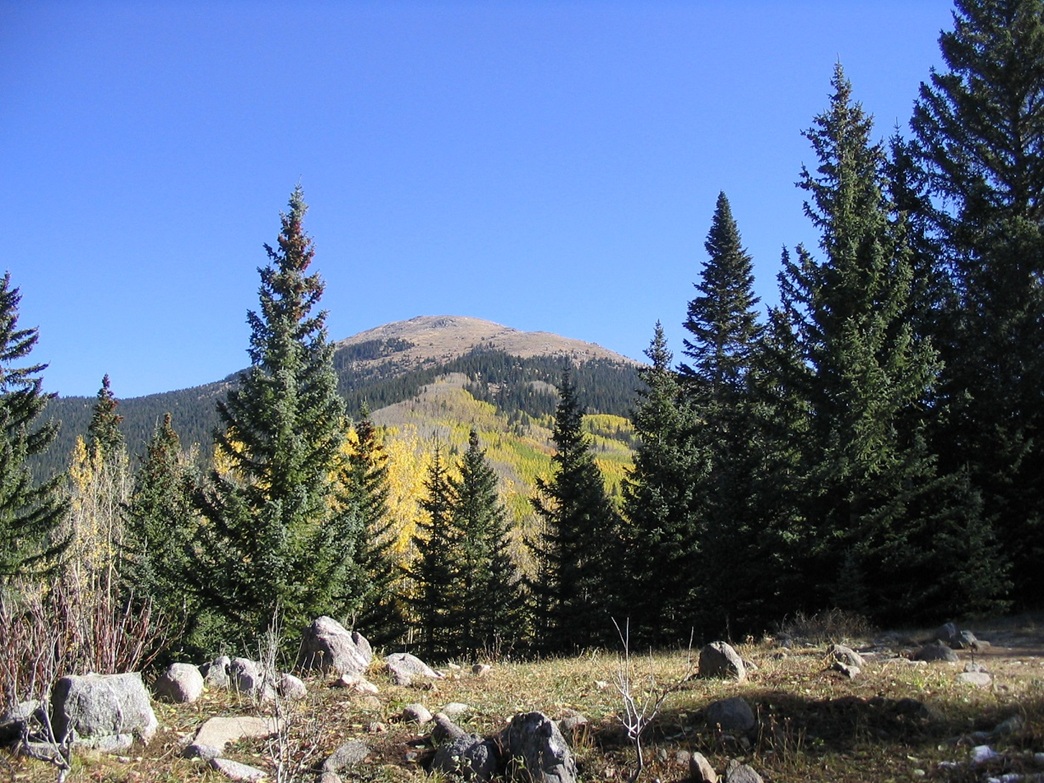
The trail reaches its lowest point at 10,260 feet near a flowing creek. We crossed the creeks, then started up steep switchbacks that eventually topped out in a beautiful meadow called Puerto Nambe. This point was about 4.5 miles in from the start and 11,000 feet elevation. The weather was awesome, and we had unobstructed views of Santa Fe Baldy to the north and the snow-covered Lake and Penitente Peaks to the south. We took a break here, buffetted by occasional brisk winds.
Rested, we turned left from the Windsor Trail onto Skyline Trail (#251) and started the slog toward the pass at 11,600 feet east of Santa Fe Baldy's summit. The trees lessened along this trail, and we had better and better views of our objective as we steadily moved higher toward the pass, which we reached after about an hour, where we again found a good excuse to take a break.
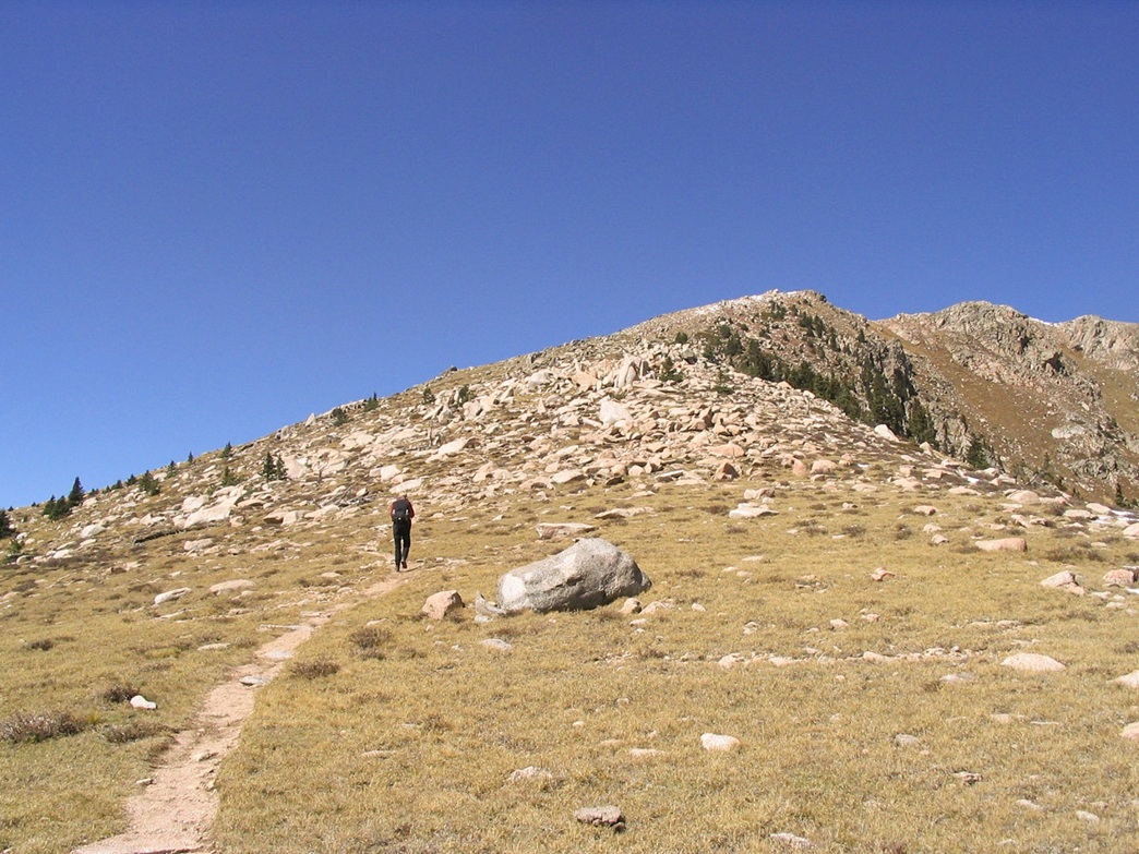
The final segment to the summit covers a mile and 1,000 feet of gain. We left the Skyline Trail at a large cairn and followed a path up toward the summit. The path wends its way through rock outcrops and is consistently steep, but never too bad and by no means technical.
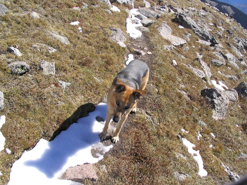
Toward the top near where the trail makes a slight bend north to the summit, I was surprised by panting noises ... a pretty doggy had materialized behind me out of thin air. She was a pretty german shepard and her owner was just a few feet behind. In fact, she hiked with me for about a minute, hopping ahead, pawing at the snow and taking a big bite of it, then bouncing back. I chatted with her owner as we hiked up to the top. A handful of hikers were just starting their descent as I walked up.
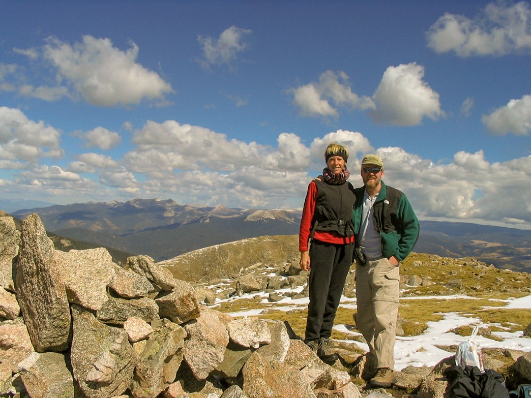
We arrived on top at 1 p.m., a four hour ascent. The weather was holding steady, temperatures in the high 40s. As long as the wind didn't blow, we were fine, but when it did, it had a real bite to it. We talked with the dog's owner, a transplanted Montanan named Peter who'd just moved to New Mexico a few days earlier. The dog's name, we found out, was Miss Lighty. We stayed on top for 20 minutes and pointed out nearby peaks. From the summit I could make out a number of New Mexico's high peaks: Redondo Peak and Caballo Mountain immediately to the west, Wheeler Peak to the far north, South Truchas Peak to the northeast, Elk Mountain to the east, Sandia Crest and the Manzano Range to the south, and way off to the southwest, Mount Taylor. The sky was clear above us and to the west, but to the east, the clouds were developing and looking mean. We felt safe, but got moving as we started to get chilled. We bid Peter adieu and started our descent at 1:30 p.m.
Our descent went fast and we had quickly covered 2.5 miles to get back to the trail junction at Puerto Nambe, where we took an extended break. A few hikers passed us going up, and Peter and Miss Lighty passed us coming down. One guy, about 50s-ish, asked me if I knew where Spirit Lake was. I got out my map and showed him, and he said something like it might be wise to bring a map next time. Then he got moving. Then, a few minutes later, we got moving too. We passed this guy, oblivious to us due to his wearing headphones. We made good time and took another extended break at the Nambe Lake Trail junction, 2.25 miles from the trailhead. At this time this guy passed us again, made some comment that it seemed farther than it looked, and started following the trail to Nambe Lake.
We both got this bad feeling that he took a wrong turn, that he meant to be hiking out to the Windsor Trailhead (like us). He seemed pretty out of it. We got moving and hiked up the final few hundred feet (and 1.75 miles) to top out at the Wilderness Boundary, where we rested briefly before descending the final 600 feet (and a half-mile) back to our car. We exited at 5 p.m., an 8 hour, 15 minute day in which we covered 14 miles round trip and a gross overall gain of close to 3,600 feet. We debated whether to contact a ranger about that dazed hiker, but could not find anyone. On the hiker's plus side, we saw numerous people hiking in as we were leaving, so he probably had plenty of company.
After relaxing and cleaning out our packs, we drove about 10 miles to the Ten Thousand Waves Japanese Spa located just outside of town. For less that $50 we got a one-hour hot spa to ourselves, open to the air but enclosed for privacy, plus a few cool drinks to enjoy. The hot waters soothed the sore muscles and afterwards, we weren't nearly as sore as we would have been normally. We then celebrated at an Olive Garden Restaurant in town before crashing for 9+ hours of deep REM sleep we so richly deserved.
We flew back to Arizona the next day. I was thrilled to complete the New Mexico County Highpoints project. I had climbed Wheeler Peak in 1994, but had not started on the county highpoints until 2000. There are two counties whose highpoints have restricted access, so finishing them all is difficult. According to the records at cohp.org, I am the 8th finisher.
|

|