The Mountains of New Mexico
• www.surgent.net
|
| Madre Mountain & Davenport Lookout |
• Highpoint: Datil Mountains • Cibola National Forest • Catron County |
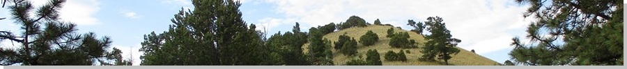
 Madre Mountain summit hill
|
Date: July 27, 2023
• Elevation: 9,556 feet (M), 9,354 feet (D)
• Prominence: 1,956 feet (M), 394 feet (D)
• Distance: 8 miles
• Time: 4 hours & 45 minutes
• Gain: 2,350 feet gross
• Conditions: Mix of clouds and sun, slightly humid
New Mexico
•
PB
Madre Mountain is the highest point of the Datil Mountains in central-western New Mexico, near the town of Datil. I was going to be in Albuquerque for a couple days and wanted to break up the drive with a couple overnights along the way and to hike a peak or three.
This peak jumped out at me pretty fast while studying the maps. There is a decent road network that gets close and allows for easy vehicle access, and all reports online suggested this to be an enjoyable, no-fuss hike, the last couple miles being overland through grassy ridges and clumps of forest.
I left Arizona early yesterday and drove to the Show Low area and knocked out three easy peaks and seeing a bear walking in a road. I then stopped in Springerville for groceires and a few supplies. Despite all this activity and me deliberately trying to waste time, it was just noon when I got back on US-60 heading into New Mexico.
Traffic on the highway was essentially zero. I did not pass any vehicles nor did anyone pass me. I stopped in Pie Town briefly to stretch my legs, waste some more time, and possibly have pie. But only one place was open and their pie selection was minimal. I was close to my destination by now, the Datil Range lying immediatelt to the east, contained within the Cibola National Forest.
I drove a few more miles on US-60 to Forest Road 6, then followed that north a few miles to a private inholding featuring a couple newer-looking log homes, but I saw no cars or people. Everything looked shut down. The road was good and the gate to the property was open, so I continued through.
Forest Road 59 branches east from here, near one of the log homes. I eased onto this road, which was rougher, and drove in about a quarter mile, going up two switchbacks. This gained me about 150 feet and placed me on top of a tiny ridge with an excellent clearing to one side. I pulled into this clearing and parked. This would be my camp.
The road hereafter was much rougher and I doubt I could have coaxed the Forester past it, so parking where I did was convenient. It was a perfect spot. It was open, but with trees on three sides so I could only be seen from someone along the road itself. I was invisible to anyone from below, had there been anyone down there.
It was 3 p.m. when I turned off the engine. I wasn't going to pitch a tent. I was just going to sleep in the car. I had the rest of the day to do nothing and this was by design. I needed to simply sit still and relax for a few hours, not always be doing something or moving from one place to another. I literally had this whole side of the mountain to myself.
The day was warm, borderline hot (in the low 90s). I was at 8,300 feet elevation, and within an hour, the monsoon storm clouds started to build. From about 5 p.m. through sunset, the storms picked up, zapped the highest ridges with lightning, and dropped a steady rain, never too intense. The temperature dropped into the 60s and felt fantastic. During lulls, I would walk around the area.
I slept okay, stretching out as best I could. It wasn't too cold, maybe mid 50s overnight. The storms had dissipated and I had a starry night, with some high clouds moving through. Coyotes howled all night. The range is home to bears but I saw none nor their sign. I wondered about wolves, but I don't think they're located here.
I was up about 3:30 a.m.. I used this time to get my stuff together. I wanted to be hiking at the first dimmest morning light as possible, to eat up some of the time for the road walk ahead of me. I started moving at 4:45 a.m., barely enough light to see by, but enough to keep me on a wide road easily. It was cool but humid. Within a few minutes I had to peel off a layer to keep from being too warm.
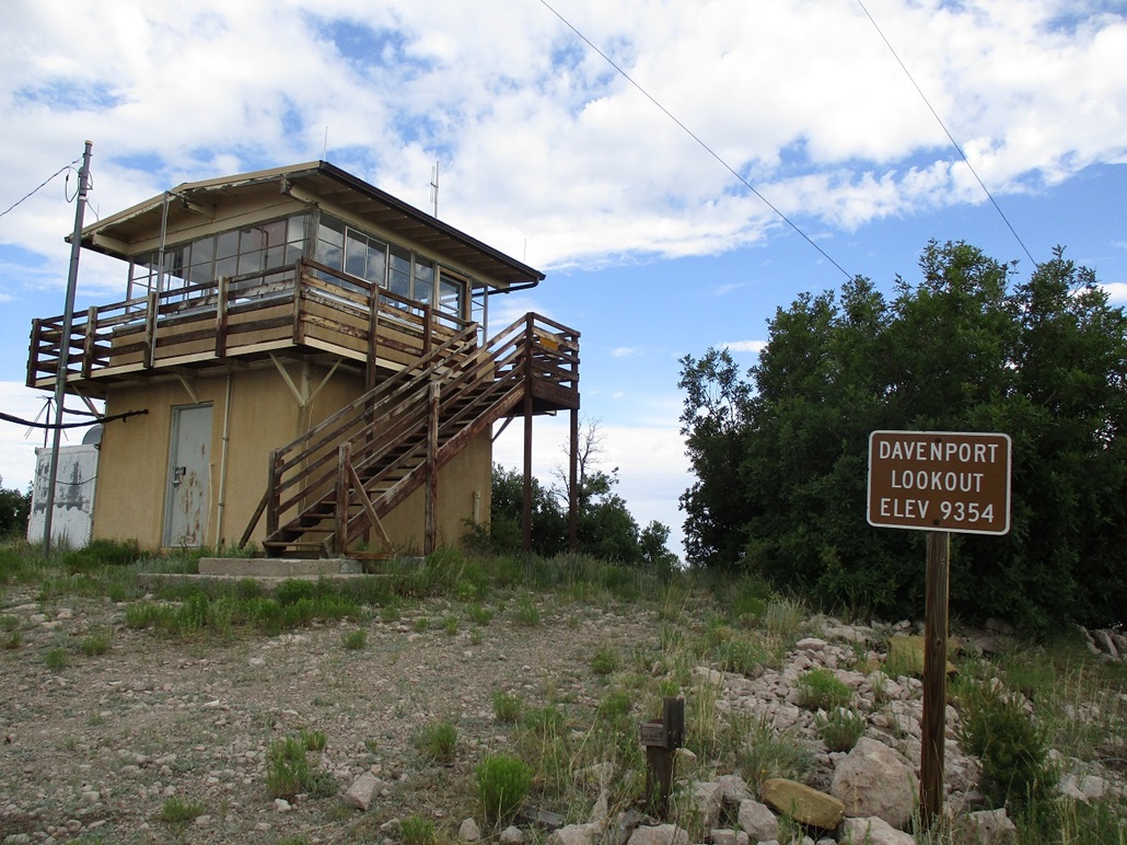
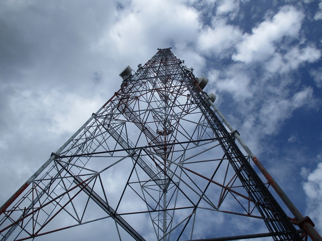
The initial segment is a 1,100-foot gain in about two miles to top out on Davenport Lookout Mountain, which also hosts a couple very big communications towers. I could see one of its giant towers from my camp, and its size played tricks on my eyes. It made the top seem lower and closer than it really was. This road segment went well and I covered the distance in about 45 minutes. I deliberately did not "summit" this peak yet, instead bypassing its top by staying on the road.
The road then drops about 500 feet in a half mile. Where the road then makes a hard rightward bend south, I went north onto a lesser track that has been bermed to prohibit vehicles, but where an ATV could easily get through. For hiking, it was perfect.
This road follows a tight canyon at first, then starts an ascent, angling up and right, topping out on a ridge. To here, I had been hiking about 75 minutes, covering a little over two and a half miles. And I had done all this in the shade. The sun was up by now but blocked entirely by the hills above me. Only now, at this ridge, was I in the sun. It was comfortable, but the bugs were waking up about now too. The sun was very intense to the east.
The track by now is not as well-defined as it was coming up, but it was still easy to follow. It splits, and I went left, this left branch busting straight up the slope ahead of me. I followed the track until it petered out. Fortunately, the terrain here was mostly open, mostly grass and clumps of trees but with open views to easily navigate by. I would find a cairn here and there, but mostly just followed common sense, heading up until there was no more up to go. This was good, as I had gained almost all the main elevation I had lost coming down from Davenport Mountain.
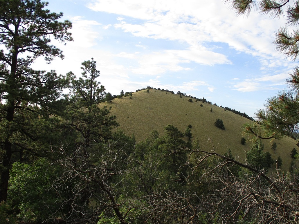
The rest of the route goes north along this ridge, which then trends east and meeting another ridge that bends south to the summit, which was now easily seen but backlit too severely by the sun for any decent photographs.
Slightly beyond the top of this first ridge bump, I picked up a trail again. It was weak in spots and I lost it at times, too. Whenever in doubt, I stayed high, going up and over the bumps. Almost always, I found the trail again, which when I could stay on it, was very helpful. It weaved neatly through some clumpy vegetation and through easy rock bands. I lost it as I neared the ridge north of Madre Mountain, but had no trouble staying on course in the general sense. I was finally on the ridge north of the peak, from which it was an easy trudge up open slope to the summit.
The one-way hike covered about 4 miles, probably a little more, taking me a little over two hours. The top is open with piñon to the side, and a small rocky cairn at the highpoint, plus two markers, one unstamped, one with a lot of stamping (see my images). I found the register and signed in. I think I was the first person here in 2023, but the register held names going way back. All the peakbagging all-stars from these parts have climbed this, plus a few from Arizona. Hunters also come here.
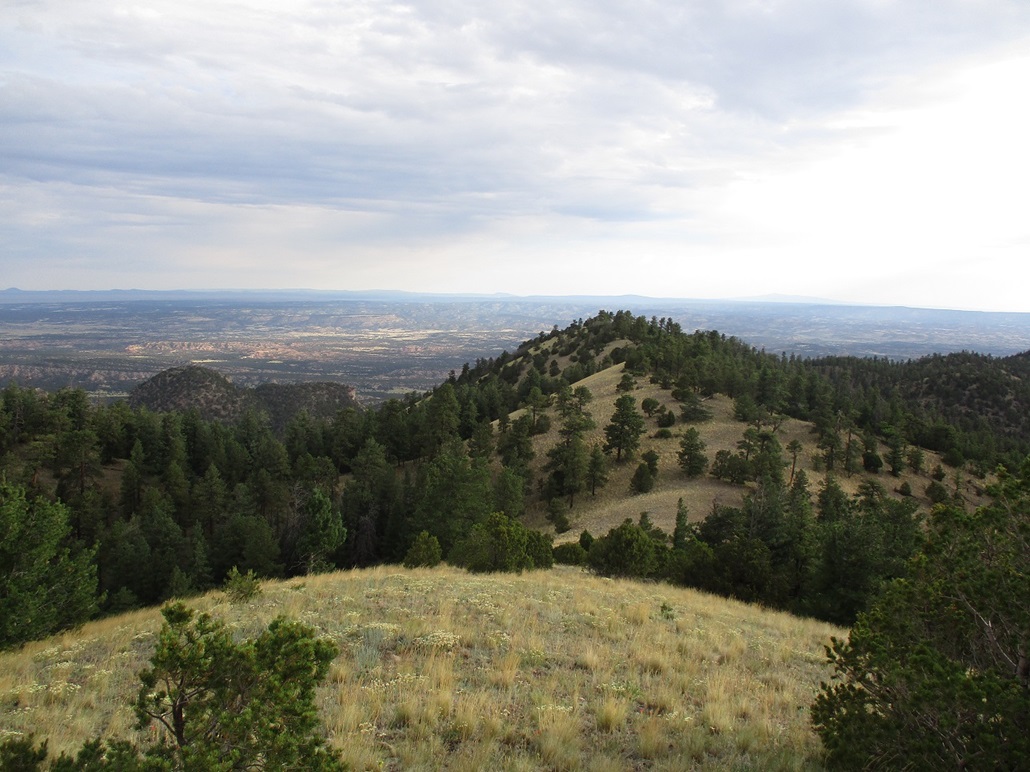
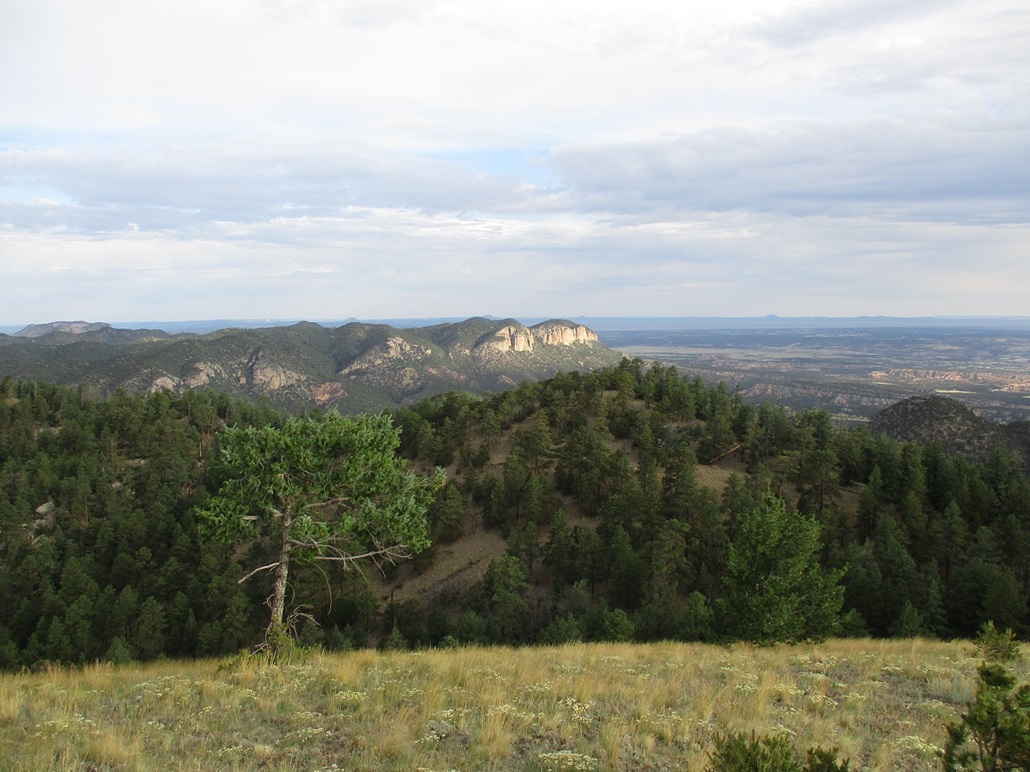
Views were very good, the sun still low in the east (it being not yet 7 a.m.). I could see interesting cliffs to the northwest. Alegres Mountain rose to the southwest. Many other big peaks jutted up above the plains but I do not know their names. I could also make out interesting canyonlands in the intervening plains too. It was cool and slightly breezy, but comfortable. Clouds were scattered, still way too early to collect into storms. I spent about fifteen minutes here, enjoying the break.
For the hike out, I retraced my route as close as possible. In the few spots where I had lost the trail, I was able to "find" it on the way out. Often, I would get back to a point I remember and no, I would never have known the trail went where it did. I was able to stay on it for most of the ridge section, and I made good time. I got back onto the ATV track, then down back to FR-59. Now it was time to properly "climb" Davenport Mountain.
I just walked the road uphill to the towers. I left the road and followed a spur to the lookout itself, which was unmanned. I looked around the area, and also walked by the actual towers. I smelled something kind of eggy, and walking near one of the towers, could hear a soft hiss where there was a line connecting a propane tank to a building. It may have been leaking propane a little.
With Davenport Mountain now properly visited, I got back on the road and walked it back to my car, arriving a little after 9 a.m.. The round trip covered 8 miles (likely more like 9) in 4 hours and 45 minutes. I had the tiniest of worry that someone from that property below would see my car, but no one did. I saw no hint of any others in the area. Back at the car, I changed quickly and started the drive out.
I drove US-60 east through Datil, then the long straightaway across the Plains of San Agustin, which is home to the Very Large Array, where over two dozen gigantic radio telescopes are laid out in patterns to form essentialy one super-gigantic telescope. We had been here many years ago, and this kind of thing always appeals to my inner nerd (and outer nerd too).
I made one side trip, to visit a lat-long confluence at 34 North, 107 West, my first such confluence visit in 7 years. It was hot, though, mid 90s, so any big hikes were out of the question for now. I then rolled into Socorro, and killed time at a McDonalds, before driving north some more to Los Lunas, to set myself up for the night and for tomorrow's adventures, starting with El Cerro de Los Lunas.
Madre Mountain had been my "big" hike for this trip. It has the most prominence (over 1,960 feet) of any peak I have climbed in many years, and it looked like a fun hike, and it was. I thoroughly enjoyed it, and found the logistics to be very easy, not always having to stop to worry about being lost or dealing with crappy brush or rock.
Regarding where I camped: at the time when I pulled into my camp spot, I was unsure if I was still on private land, or back on forest land. A sign at the junction with FR-59 had a small tent icon on it, suggesting camping spots were up ahead. I did not feel worried where I was. But when hiking the road the next morning, I saw the forest boundary sign up ahead. A proper high-clearance, with recommended 4-wheel drive, can get up the road, certainly past the forest boundary. Otherwise, an option would be to park low, south of the gate entrance of the property, and walk the road. Generally, staying on road is acceptable, especially if gates are already open. Parking and camping where I did is a judgement call. I felt okay, but others may feel differently. Had there been anyone at the property to ask, I would have done so. On my visit, it looked vacant, although kept up. So someone or people do use it.
|


|