The Mountains of New Mexico
www.surgent.net |
| Mesa Leon |
• Highpoint: Guadalupe County |
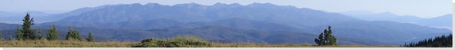
 Mesa Leon, photo taken 2007 |
Date: October 21, 2001
• Elevation: 6,339 feet
• Prominence: 359 feet
• Distance: 6.7 miles
• Time: 2 hours and 15 minutes
• Gain: 520 feet
• Conditions: Clear and lovely
New Mexico
•
PB
Mesa Leon is the highest point in Guadalupe County, about a two-hour drive east of Albuquerque. The land here is mostly flat plains and high desert rangeland, but toward the western boundary, there are a few mesas that rise above the flats, such as Mesa Leon.
I was here in March 2000, staying the previous night in the town of Vaughn, about 10 miles to the south. On that attempt, the day started with a late-Spring snow "storm". It was a slow-moving front that dropped big, wet, slushy snow. It wasn't collecting very fast so I thought I might be able to hike to the top anyway.
I spent some time trying to find the right road out of Vaughn (I needed Road 4F). This took some time because nothing was marked. I assume the locals know all the roads so why bother putting up signs? I found the right road and then located myself west of the mesa. It is surrounded by fencing. I expected this, having done what research I could beforehand. It's all private lands out this way.
The west gate was open so I entered, following the main road up the mesa. By now, the snow was collecting, so I parked and started to walk. However, I was high enough to be in the fog. With the snow falling and no sense of direction due to the white out, I retreated and hiked back to my truck. I don't think I got farther than a few hundred yards anyway.
Back at my truck, I was amused to see about thirty head of cattle slowly walking up to me and my truck! I had passed them lower down, and I guess they equate any vehicle with food and possibly pets and ear-scratches. I wanted no part of them. I got back into my truck, and slowly inched downward, encouraging the cattle to move aside. They did, but this all added time. I was able to get back to Vaughn and onto pavement. Given the snowy conditions, I bailed and drove south to the Carlsbad area to let the storm pass.
I returned to the region about 18 months later, with spectacular late-October conditions. My primary goal of this visit was to hike in the Manzano Mountains and visit the highest points of Valencia and Torrance Counties. This I did yesterday, encompassing 15 miles and most of the day. I had today (Sunday) open, my flight not leaving Albuquerque until this evening. Thus, I drove to Vaughn and stayed at the same hotel I did in 2000, with plans to retry a hike up Mesa Leon.
I left the hotel very early, and knowing the roads better now, knew where to go. The drive to the fences surrounding Mesa Leon took me about 20 minutes. I first drove to the west entrance, the one I had come to last year. However, I decided to check out a southern entrance. I backtracked south on Road 4F to a Y-split, and then went north on the lesser-quality road a hundred yards or so to a gate. I parked, noting that I was reasonably hidden from the main road by brush, and that it was a Sunday. Thus, my chances of being spotted were lessened.
The gate was ancient, and there was an old sign hanging on it, its letters completely buffed off from years of sun, rain and dust. I held it at an angle and yes, it said "No Trespassing". I expected this. I knew this was posted land. I gambled and went in anyway. If someone were to approach me, I could play dumb, beg for forgiveness, and leave. Lucky for me, there was no one around, at least not nearby me.
I walked north along the sandy road over a mile and a half until I was abeam of the mesa's west slopes, which were more like a jumble of small rock cliffs and vegetated ramps. I left the road and picked my own way through this terrain. It was never more challenging than class-2, but it was brushy and slow-going. Nevertheless, it didn't take too long until I was now atop the mesa.
The top was a delightful spotty forest of juniper and pinon with shin-high grasses and light brush. I walked east and descended into a natural "amphitheater", then up the opposite side. The map shows a road encircles the top of this mesa. A year ago in the snow, I lost the road. I was able to find the road today, so I followed it, but then, the road simply petered out.
The road would have helped because it would have saved time and helped with my bearings. Instead, I walked east and northeast, following the lay of the land upward. I had about 300 feet of line-of-signt navigation, which helped me a lot. In this manner, I was able to locate myself at or near the highest contours atop this mesa. I crossed a slight rise, a region that includes one of the two 6,330-foot contours that define the highpoint. Finally, I came upon the road again at a point where it dips slightly between the two highpoint areas.
The second 6,330-foot contour was about another 10-minute's walk east. After about 15 minutes of wandering within this highpoint contour, I found the knee-high cairn, benchmark, and the remains of an old lean-to. The benchmark is at 6,339 feet and is highly likely to be the highpoint, higher than the first contour area I crossed. The whole hike in, including wandering around on top, took 1 hour and 20 minutes.
On the hike out I followed the road most of the way until it became rockier and faded into nothingness. At this point I went cross-country again, down-climbed the mesa and walked out the lower ranch road back to my truck. I was still concerned somebody would see me, so I walked fast, but as it turned out I was totally safe. The walk out took just under an hour. Overall the hike covered 5 miles round trip and about 600 feet of gross gain. I enjoyed it.
It was still early, not yet 10 a.m., so I drove back to my hotel, showered, then drove into Albuquerque to kill time before flying out that night. I was tired, and wanted a place to nap in air-conditioned comfort, so I found one of those dollar theaters and watched the remake of "Planet of the Apes", or more accurately, slept through it.
|
|