
The Mountains of California
• www.surgent.net
|
| Mount Whitney |
• Highpoint: State of California and the coterminous United States • Highpoint: Inyo & Tulare Counties and Sequoia National Park • Highpoint: Sierra Nevada and the most prominent mountain in California |
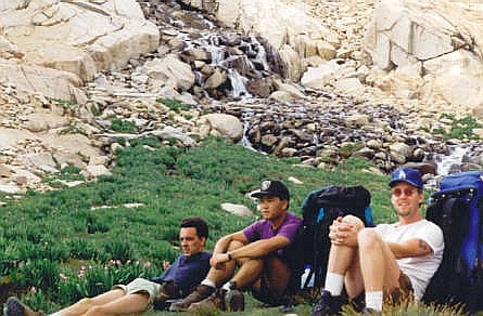 Rest. I'm wearing the Dodgers cap
. . . . . . .
Summit Panoramas
Panoramas from the summit, as created by Jonathan de Ferranti, a map-wizard based in
Scotland. His highly-detailed images describe the distant horizons, ranges and peaks, with compass bearings and distances provided. They are remarkable and, in my opinion, beautiful works of artPlease check them out!
|
Date: July 17-19, 1992
• Elevation: 14,495 feet
• Prominence: 10,075 feet
• Distance: 22 miles
• Time: 10 hours (summit day)
• Gain: 6,500 feet total
• Conditions: Sunny and pleasant
• Teammates: Pals from UC Riverside
California
•
Main
•
PB
Mount Whitney is the highest peak in the coterminous "Lower 48" United States. That alone was reason to think about climbing it. At the time, I had hiked exactly one peak of significance in my life, Telescope Peak in the Panamint Mountains a year ago. I was aware a trail led to the top of Mount Whitney. It looked like an interesting challenge.
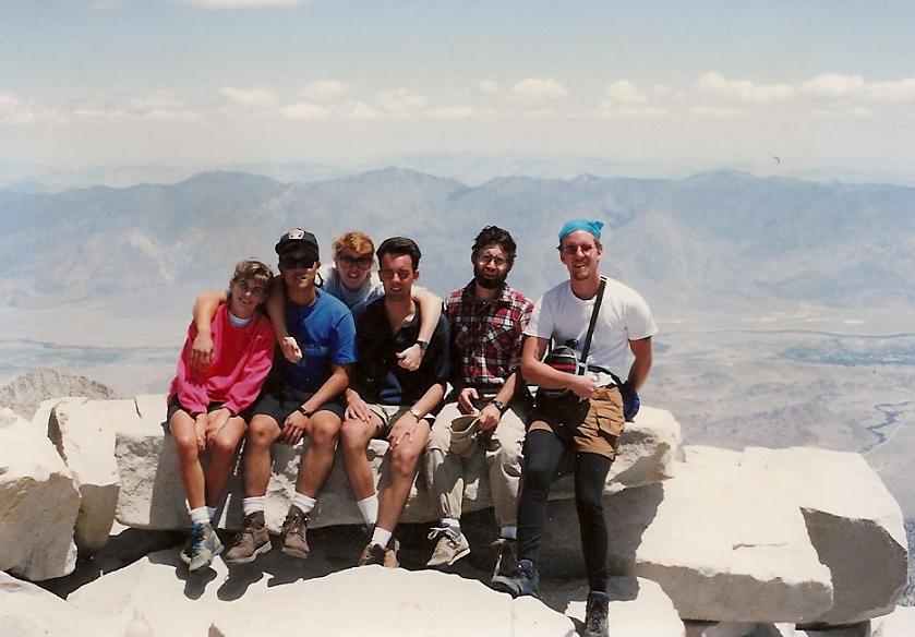
There were six of us, all of us current or former students at the University of California, Riverside. I had just graduated in June with my Masters Degree, and would move to Arizona in less than a month. This hike was a nice way to cap my time (22 years) in California.
We convened in Riverside one evening and drove to Lone Pine, arriving near midnight. Four of the group set up camp in a camping area outside of town, while I and one other went back into Lone Pine to position ourselves for getting back-country permits the next morning. At the time, unused permits would be handed out each day, first come, first serve. This meant we had to get into line early, like at 1 a.m. early. We were second or third in line, and we sat there all night and chatted with others. By dawn, the line was pushing 50 people, and we were able to get permits ... but we got no sleep.
We drove back to meet the others, then drove to the Whitney Portal, elevation 8,800 feet. We started hiking at 9 a.m. in clear, pleasant conditions. We followed the trail, which was a delight, passing through pine forests, lakes, meadows, and higher up, rocky slopes, waterfalls and small tarns. There were many hikers here, many, like us, with big packs aiming for High Camp at 12,000 feet.
One enduring memory is seeing a neat row of parallel vertical gouges in the bark of a tree, from about ten feet up to about three feet up, the gouges a couple inches deep. These were the scratch marks of a grizzly. If it can do that to a tree, imagine what it can do to a person. We did not see any, fortunately.
Higher up, I was lagging. I was exhausted from no sleep and feeling the effects of altitude. We strung out here, and I was among the last to arrive to high camp. I got the tent built then immediately crawled into my bag for a nap. A couple hours later, we cooked dinner, and I felt a little better, but not much. I had a headache, due to altitude, tiredness, and dehydration. This was my first time ever at 12,000 feet. In spite of my aches, I slept well, mainly out of exhaustion.
The next morning, I felt better. We got our stuff together and started hiking the switchbacks above camp, our immediate goal the ridge about a thousand feet higher. This segment contained about 100 switchbacks and portions where the trail was still snowed over. But we plugged along and in time had arrived onto the high ridge. We crossed into Sequoia National Park up here, a small sign telling us so.
We continued northbound along the trail, which stays high on the ridge and skirts big pinnacles along the way. We dropped 300 feet at one point, and just kept walking. Finally, rounding a bend, the summit was visible, still a mile away. We strung out again, and I was hanging back toward the end. When I arrived on top, I was elated but also bonked. I planned to linger just for a few moments then head down. However, the last of our team was not far behind me, and when she arrived, we all stuck around for about an hour.
The top is broad and rocky, with a stone cabin. The day was clear, bright blue and pleasant. I had never been this high before (and haven't since), and I could really feel the elevation. I felt generally clumsy and tired, catching a full breath difficult. We got some photographs, looked around, had lunch, relaxed, and finally, started our trek down.
The hike down went well. Ironically, I was in the lead, and I was first back at camp, although not by much. I napped in my bag for an hour or two, then we made dinner and had a relaxed night at camp. We hiked down the next day, and celebrated with a hearty meal at a cafe in Lone Pine.
The hike was a success and it was especially nice to "conquer" the highest peak in California. It was a good team and we all did well, helping one another out whenever needed. In three weeks, I would be in my new home in Arizona. Being so new at this hobby, I was definitely hooked, but I still had a lot to learn. I made a number of rookie mistakes, such as...
• Pack better-tasting food. I packed bags of gorp, which is peanuts, chocolates and raisins. I was hated it after a half-day. I still hate it, all these years later. Individually, I like the ingredients, just not combined.
• I did not dress properly. I wore shorts and a t-shirt for the summit hike, with no cap and no sun-screen. I knew I'd probably get burned, but I had no idea how bad. It was bad. I knew I was cooked when I had returned to camp after summitting. I could feel the heat radiating off my face. In the ensuing couple of weeks, my skin blistered and peeled. I had given myself a stage-2 burn. I wore cotton and did not carry a heavy all-weather jacket. Had a storm hit us, I would have been in bad shape.
• I was not careful with my water. I think I caught a bug from poor filtering. I had stomach issues for about a week afterwards. It was not as severe as I have read in other cases, but it was unpleasant. We did filter our water, but probably not good enough.
I feel fortunate to have hiked this wonderful peak when (and how) we did. Back then, getting a permit was a minor hassle, but not impossible. These days, it's a major hassle and many people simply don't get picked in the lottery year after year. My teammate pals were great and we all helped one another on this journey and I am grateful for that too.
|


|