The Mountains of California
www.surgent.net |
| Snow Mountain |
• Highpoint: Colusa & Lake Counties • Highpoint: Berryessa Snow Mountain National Monument • Mendocino National Forest, Snow Mountain Wilderness • Northern California Coastal Ranges |
 Snow Mountain from the trailhead
|
Date: July 25, 2005
• Elevation: 7,056 feet (Lake County), 7,040 feet (Colusa County)
• Prominence: 2,496 feet
• Distance: 8.5 miles
• Time: 5 hours and 30 minutes
• Gain: 2,300 feet (gross)
• Conditions: Outstanding
California
•
Main
•
PB
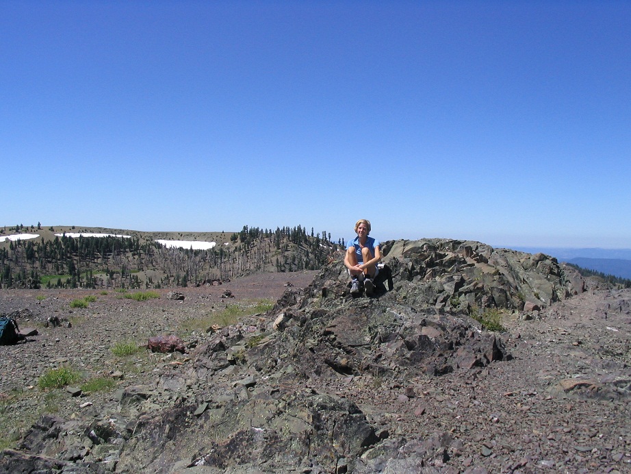
Snow Mountain East Peak is the highest point for both Colusa and Lake Counties, located in the coastal ranges separating the Central Valley from the oceans. The county line actually runs between two mounds of rock atop the summit, one mound being Colusa County's highpoint, the other being Lake County's highpoint. The summit of this peak is the one inside Lake County.
We were here for my sister's wedding in Berkeley. We had flown into Sacramento, drove to Berkeley, and had a fun time with family and friends. After the festivities, we drove north to the town of Williams, in Colusa County, where we stayed at a Motel-6. Snow Mountain Peak is visible to the west, but still sixty road miles away.
The drive to the trailhead went well and was scenic. Once off of the Interstate corridor, the roads narrow and the hills grow taller, encompassing a number of remote, bucolic ranches. The towns out here, Lodoga and Stonyford for example, are small places, seemingly in a time warp from fifty years ago. Past Stonyford, we traveled to Fouts Springs, then a long stretch of well-graded dirt road (Mendocino Forest Road M-10) that led to a 4-way junction along the spine of the main ridge. The final two miles, going straight, were up steep road, but still passable in our Chevy Impala rental car.
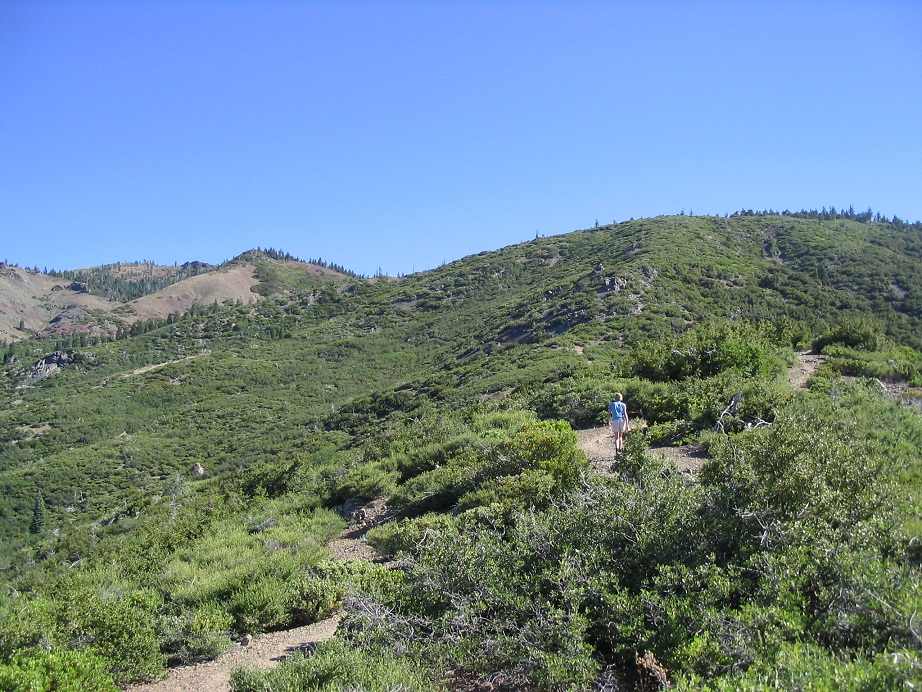
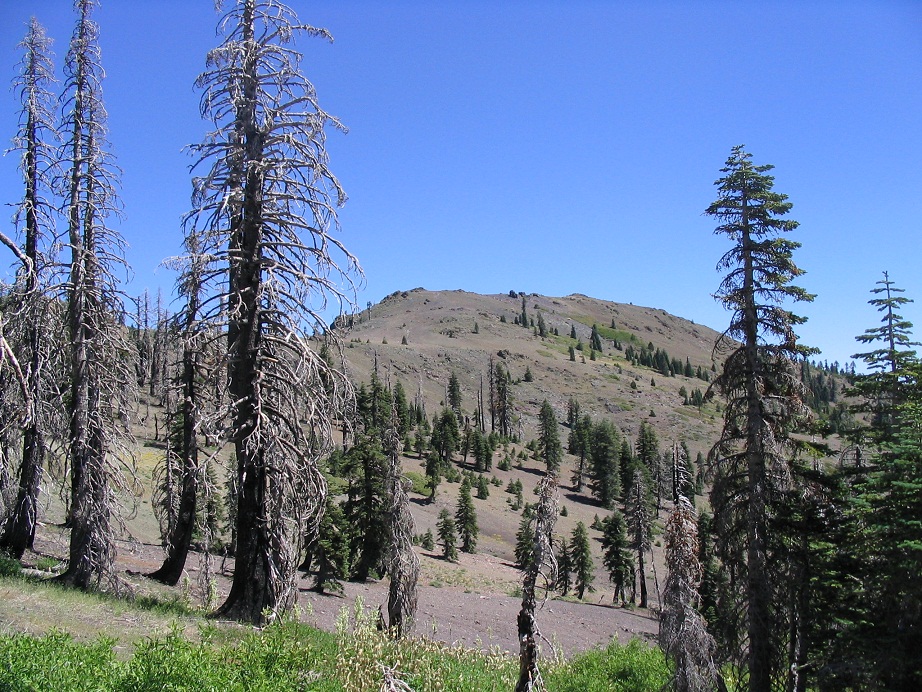
The day was stunning, with blue skies and pleasant temperatures, and no clouds. We were the second car in the lot. βð's back tightened up, so we spent about an hour here so she could loosen it (I helped) and give her meds a chance to kick in. We walked to the trailhead and went left along trail. Within minutes we had gained a small amount of elevation and had emerged from the trees to an open ridge. After passing a minor saddle, we started up a steep segment, entering onto a treeless slope covered in thick brush and chaparral. This section had been burned in a forest from the 1970s. Burned tree hulks still stood in place, and the views, as a result, were open and unobstructed. The trail made one switchback, then worked its way into a side canyon where the forest took over again, dominated by large fir, ferns, brush and a running stream.
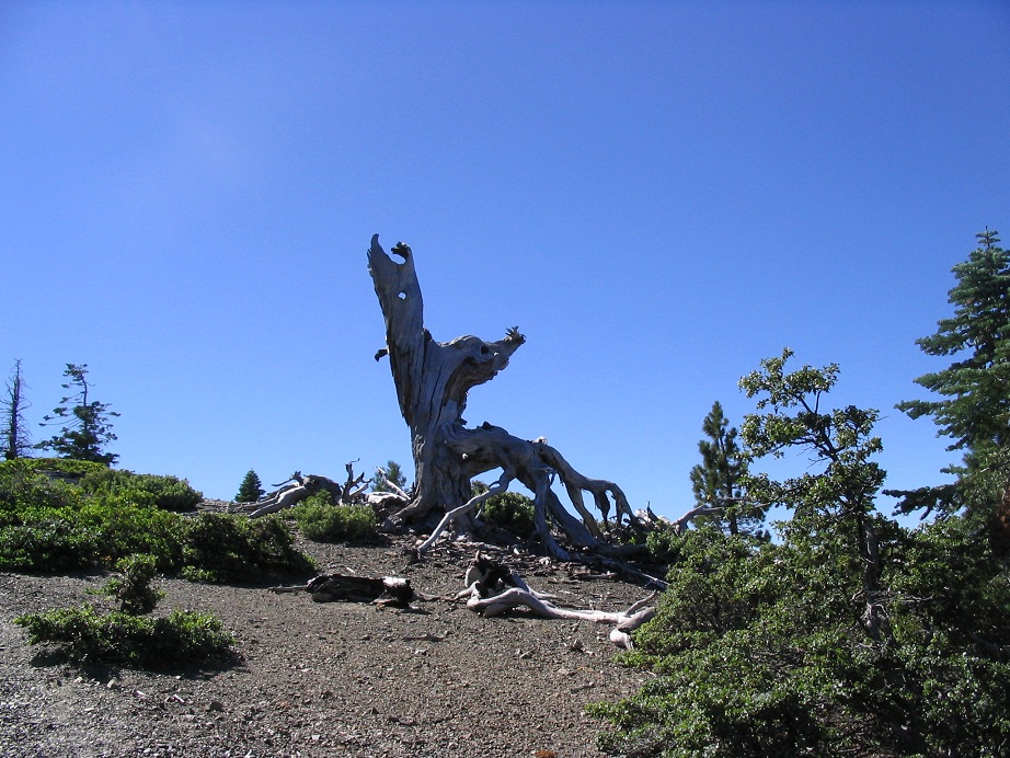
The trail made many switchbacks here, eventually achieving the main ridge of the range in an open section with dead standing tree hulks, some weathered into beautiful, eerie shapes. The terrain itself was rubbly rock and sections of impressive rock outcrops. Shortly, the trail begins a gentle descent, once again in thick forest. It comes to the junction with the trail from Fouts Camp (written as "Foutch" on the sign), and bottoms out at a small marsh.
Walking across this meadow, we re-entered the forest and started a long uphill section, paralleling a drainage. The final segment grew steep as it gained the headwall, and re-emerged onto another small saddle, east of Snow Mountain's West summit. For the first time, we could peer across the small bowl to the north and view Snow Mountain East, our objective. We had been hiking 90 minutes at a moderate pace, gaining 1,500. We took an extended snack break as a reward for our efforts.
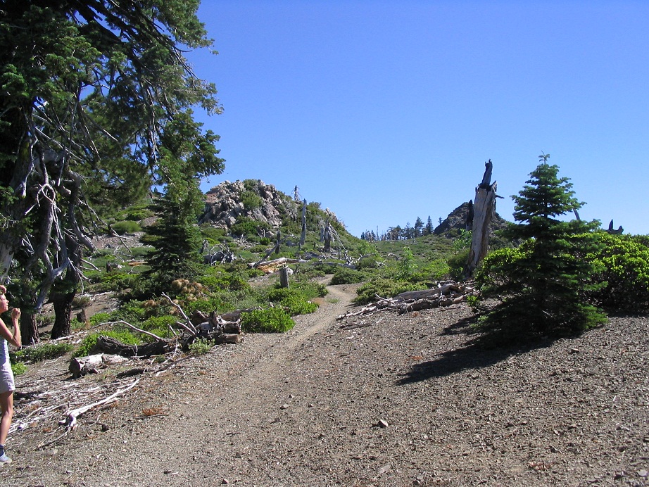
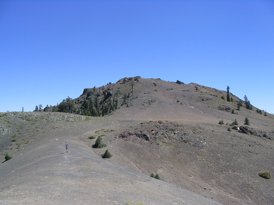
After 20 minutes, we resumed the trek, descending into a bowl hemmed in by the two Snow Mountain peaks and the ridges that connect them. To our surprise, there were still snow banks hanging on the highest ridges. The trail descended into a mix of meadow, spotty forest of low pine and a recent burn section of blackened snags. Past this, we followed the trail toward the summit. We hopped over small creeks, paralleled a running stream, and worked our way up the steepening path as it gained the low saddle separating the West and East summits. Flowers carpeted the slopes, and the trees gave way not long thereafter, leaving us a genuine sub-alpine ascent to the top.
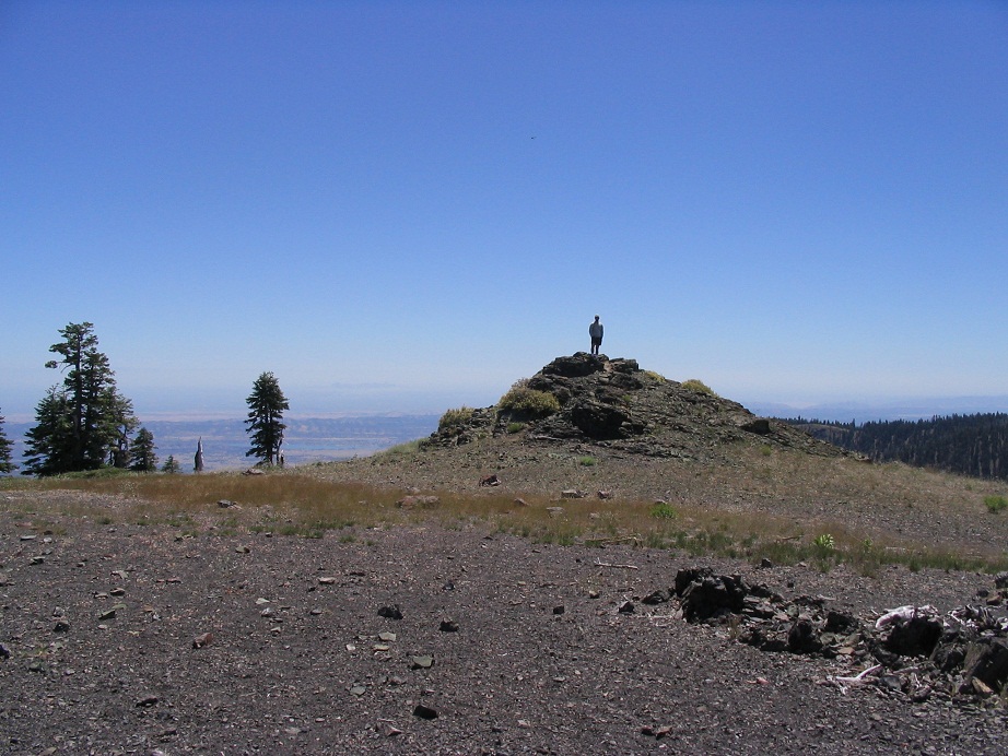
At the saddle, we turned right, crossed a gravelly pass, then up a steep, somewhat loose path to the flat summit, arriving slightly before noon. The summit area is about the size of a football field, with rock outcrops in places. The highest of these rocks is the summit of the mountain, and lies within Lake County. We found the register in a strong box affixed to the summit rocks, and signed in. This is a relatively popular summit, and sees a handful of visitors on a typical weekend. Being here on a Monday, we had the mountain to ourselves. After a break for photos, we walked 200 feet southeast to the next big pile of rocks, the Colusa County highpoint. The rock scrambling was easy, each with 10 or 15 feet of gain. We took many photos and breaks as the views and the weather were gorgeous.
We started our descent after 30 minutes, making excellent time going downhill. We took an extended break near the Fouts Spring trail junction (and met a hiker coming up), and were back out to our car within two hours, arriving at about 2:30 p.m. We had a hotel in Fort Bragg waiting for us. The wisest thing to do would have been to retrace our route back into the Central Valley, then take highways to Fort Bragg.
Instead, we gambled and continued westbound on Forest Road M-10, knowing nothing about its condition or obstacles. The first few miles went well, and the road was good. I made one left at a junction with a sign saying "Upper Lake", the destination, a small town at the north end of Clear Lake. But we still had 30 miles to go on forest roads.
Soon, we came to a significant obstacle: a broad rocky riverbed and a running stream at the far end about 12 feet wide and maybe 10 inches deep. In a truck or any large vehicle, this would have presented no challenge at all. But we had a low-slung Chevy Impala, which up to this point had performed admirably well, but potentially was not capable of fording this stream. We had no desire to backtrack 70 miles then make a long detour west to get toward Fort Bragg. I parked and inspected the entire length of the creek. I moved aside two or three bigger rocks and inspected the stream crossing. It was moving slow. I built up some of the tread with smaller rocks.
Slowly, I drove 150 feet or so along the bumpy river rock, stopping a few feet short of the stream crossing. I picked up momentum, entered into the stream, kicked up all sorts of water and for a moment felt the car lose traction. But momentum carried it forward and its front wheels found the rocks again, and just as fast, we were on the other side. (Whew!)
Concerned about stalling the engine, I kept driving until I felt we were okay, then we parked for an inspection. There was a disconcerting rattle on the front driver's side, and no amount of inspection could reveal the culprit. The car ran fine and after a few miles the rattle stopped when a rock fell out of the front wheel well. The rest of the drive went slowly and up and down over a bunch of hills, somewhat tediously, until we came out onto pavement and down into the town of Upper Lake, where we rewarded ourselves with cool drinks.
We spent the rest of the day driving to Fort Bragg, arriving about 5 p.m. in cool, brisk weather, a huge change from the heat and dryness from where we came. We had a fine dinner at a local brew pub and an enjoyable couple of days exploring the region. Two days later we visited Anthony Peak, the Mendocino County highpoint, before flying home the next day.
|
|