The Mountains of New Mexico
www.surgent.net |
|
Sierra Blanca & Lookout Mountain |
• Highpoint: Otero County (Sierra Blanca) • Highpoint: Lincoln County (Lookout Mountain) • Highpoint: Sacramento Mountains • Highpoint: Mescalero Indian Reservation • Most Prominent Mountain in New Mexico |
 Lookout Mountain from Sierra Blanca
|
Date: July 14, 2001
• Elevation: 11,973 feet (Sierra Blanca), 11,580 (Lookout Mountain)
• Prominence: 5,533 feet (Sierra Blanca), 400 feet (Lookout Mountain)
• Distance: 9 miles
• Time: 6 hours
• Gain: 2,800 feet
• Conditions: Clear at first, humid with clouds building by noon
New Mexico
•
PB (Lookout)
•
PB (Sierra Blanca)
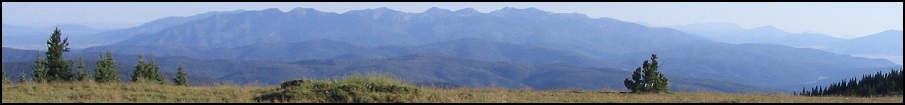
Sierra Blanca is New Mexico's most prominent mountain, and the only one in the state to exceed 5,000 feet in prominence. It is a giant peak that looms over the deserts below, with almost 8,000 feet of elevation differential in some cases. Not surprisingly, it can be seen from a hundred miles away. It is the highest point of Otero County. A bump on the ridge to the north called Lookout Mountain is the highest point in Lincoln County.
I was here a year ago, but I timed my visit just as a major hurricane had slammed into Texas, and was now breaking up over New Mexico. I landed in El Paso and drove to Ruidoso in heavy rain and non-stop lightning. Things did not look promising.
The next day, I woke early. I had stayed at a very cheap motel in town, and had trouble locking my hotel door, so I left it unlocked. I drove up the road to the Apache Ski Area, where the trails to the peaks start. However, I encountered extremely thick fog. This effectively cancelled any hiking for the day, so I returned to Ruidoso.
It was still early, not yet 6 a.m., and I was still tired. So I broke back into my own room at the hotel and slept a little more. When I awoke, the day had cleared and I drove south into Texas for my other planned hike, this one up Livermore Peak.
So this year, here I was again. I flew into El Paso and drove to Ruidoso, staying at a different hotel this time. There were no decaying hurricanes this time, just still, hot and humid weather. Highs in Ruidoso were in the 90s, with daily thunderstorms. But these are predictable, and I knew I would have until about noon to get to the tops and be heading down before the storms built.
My flight into El Paso was amusing. My seatmate was this lady who wouldn't shut up. She bugged the stewardesses for whatever free stuff they had, so that she could give these out as Christmas gifts later on. I knew this because that's what she told everyone within thirty feet. She was very annoying, and it was clear she wanted to talk my ear off, so I pretended to be asleep. Fortunately, the Phoenix-El Paso flight is only about an hour.
I was anxious enough to get started hiking so that I was up extremely early, dressed and at the trailhead at 4:30 a.m., the sun still about a half hour from rising. I had a partial moon, so I started in anyway, hiking up the trails in the pre-dawn blackness. The moonlight was barely enough to allow me to see the trail.
The trail is a good one, regularly maintained, and part of an extensive network of trails in the area. I followed Trail #15 into the forest, paralleling a creek. The trail gained at a pleasant grade for a quarter-mile, then made a switchback and gained another quarter-mile to a junction with Trail #25, elevation 10,200 feet. Aside from a small stand of trees at the start, most of the first half-mile was open grassy slope. easily visible in the dim moonlight. When it passed through the trees, I had a flashlight handy to ensure I didn't step on anything I shouldn't be stepping on, or lose my way.
I made a left turn at Trail #25. It contoured for about a half-mile through a forest, and actually lost about 50 feet over this period (I didn't notice the drop going in, but coming out, tired, I certainly noticed it). The trail then opened up again in a grassy meadow, then began a short series of switchbacks in the forest before again opening up again in the grass. I was roughly at the 11,000-foot mark, and the sun was starting to come up. I could see the Ski Apache complex across the drainage, and Lookout Mountain's bald top was visible above the trees. I was making excellent time, as it was barely 6 a.m.
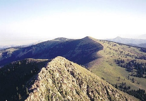
Finally, Trail #25 merged with Trail #78 near Ice Springs, where the trail contoured through one final batch of trees, then to a saddle, and then steeply up an old set of jeep tracks up a grassy slope toward the top of the ski runs. I hiked behind a lodge building and up the final grade to the top of Lookout Mountain, elevation 11,580 feet. I arrived at 6:30 a.m. in cool weather and no breeze. I had seen no one on the trail and there apparently was no one in the buildings at the top, though I did hear a generator buzzing away.
Lookout Mountain has a cicular concrete slab about 10 feet in diameter on its summit, with a stone wall and benches. Markers indicate nearby peaks, with, of course, Sierra Blanca towering above to the south. I stayed on Lookout Mountain for about 15 minutes, then started down the other side toward Sierra Blanca.
There is no maintained trail to Sierra Blanca, but the whole route is open and up grassy and rocky slopes. There are paths beaten in by previous hikers, but more often than not I made my own way. Down from Lookout Mountain, I followed the jeep tracks, then across a grassy field to a breach in the snow fence at the border of the ski area, and from there down to the saddle between Lookout and Blanca, elevation 11,150 feet.
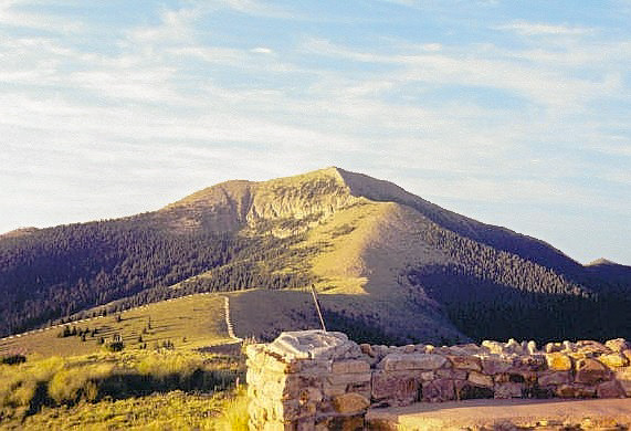
From the saddle, Sierra Blanca looks imposing. First, I had to hike up a steep grassy slope up to a rock knob at elevation 11,672 feet. This tired me, and I was feeling the effects of altitude, too. I rested often, distracted by the awesome views. At this rock knob, I stowed my pack and hiked across a somewhat level section of exposed rock. From below, it looks like a serrated knife-edge, but actually it has plenty of room for maneuvering and I was never in any danger of plummeting to my death.
In short order I was at the base of the final push to the summit, still about 350 feet above me. The route from here follows a faint path through rocky obstacles which, while looking impressive, do not require any technical experience other than route-finding. This was a fun section, albeit steep. I arrived onto the summit at 8 a.m.
I stayed at the summit about 20 minutes, taking photos, signing the register and looking out over the valleys below and the distant ranges. White Sands was visible way off to the southwest. The weather was superb, and the views magnificent. With its prominence, Sierra Blanca offers probably the best views from any peak in New Mexico. I could see half of New Mexico, it seemed.
Soon, I was on my way down. The hike down went quickly, although I rested often, especially on the hike back up Lookout (I didn't go back to the top, but instead followed the road around it). I started to see more hikers as I hiked down. I thought about taking a ski-run back down but figured it would be easier on my knees to take the trail. At least I would get to see what I couldn't in the pre-dawn dark. I arrived back to my car at 10:45 a.m., a total of six hours and nine miles of hiking, with a gross 2,800 feet of gain.
I spent the rest of the day driving down the roads north through the town of Nogal into Carrizozo, then south back to Alamogordo, where I got a hotel room at 1 in the afternoon. I showered and took a long nap. I didn't do much the rest of the day, and my drive back to El Paso and flight home to Phoenix was uneventful, other than a bumpy flight. There were no yackers sitting next to me.
|
|