The Mountains of Hawaii
• www.surgent.net
|
| Mauna Kea • Pu'u Weki'u |
• Highpoint: State of Hawai'i • Highpoint: County and Island of Hawai'i • Most Prominent Mountain in Hawai'i • 15th Most Prominent Mountain on Earth • Highest Mountain (Base to Summit) on Earth |
|
Date: July 6, 2006
• Elevation: 13,796 feet
• Prominence: 13,796 feet
• Distance: 0.5 mile hike
• Time: 30 minute hike, all day journey
• Gain: 230 feet
• Conditions: Cold
Main
•
PB
Mauna Kea is the highest and most prominent mountain in Hawaii, its summit nearly 14,000 feet above sea level. Clouds rarely accumulate this high, and the skies are among the cleanest and clearest in the world, resulting in a number of astronomy facilities being built atop the peak. As such, good roads go all the way to the top, so "climbing" Mauna Kea is logistically simple. For a variety of reasons, we opted to go with a tour group rather than on our own.
We were visiting Hawaii for ten days, split between Kauai and the Big Island. We arrived in Kailua-Kona in the mid-afternoon after a short flight from Lihue, Kauai. The change in scenery was sudden: whereas Kauai had been lush and green, the west half of the Big Island was a veritable rock and lava desert. This "dry side" and "wet side" effect is present on all the Hawaiian Islands, mainly a function of the trade winds, but the scale of the Big Island, and its gigantic mountains, makes the effect much more dramatic here. This was my first time ever on the Big Island.
The Big Island is the youngest of the Hawaiian chain. The islands are a series of volcanoes that grow over a hot spot of magma. As the tectonic plate slowly moves off the hot spot, the volcanoes die out and weather away, and new ones grow. Relatively younger than its mates, the Big Island is essentially five major mountains fused into one mass: Kohala, Mauna Kea, Hualalai and Mauna Loa, plus the active Kilauea, which for now does not look like a mountain, but it surely will grow into one, many hundreds of thousands of years down the line.
Kailua-Kona (or just "Kona", as it's usually known) lies on the west slopes of Hualalai Peak. Hualalai rises to over 8,000 feet elevation, and without any foothills, the rise is consistent and quite impressive. The mountain seemingly thrusts out of the ocean and disappears into the clouds. Maunas Kea and Loa are nearly 6,000 feet higher than Hualalai, but farther away and hidden by the clouds. There is no flat ground here. All the grounds slope down from the peaks into the ocean. The scale is so profound that it messes with your senses. You get tricked into thinking you're leaning all the time. Needless to say, I loved every minute of it.
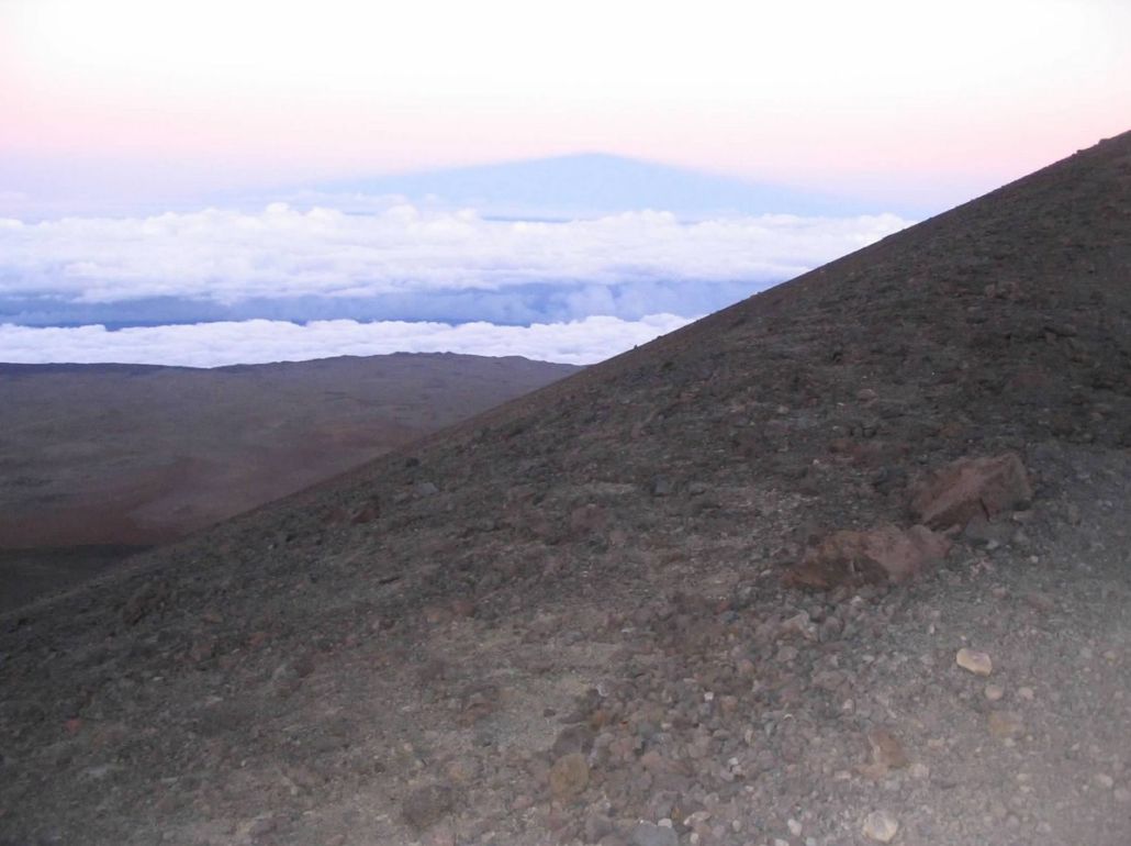
The scale of Mauna Kea has to be seen to comprehend. The mountain, like all the other volcanoes in Hawaii, are shield volcanoes, which build up by layers, forming massive, symmetric humps that are so wide and broad, that it makes the vertical height seem less. The slopes are smooth and consistent, so there are no smaller peaks or foothills by which to gain a sense of scale. The two Maunas, Kea and Loa, may be the single largest "things" on earth. Mauna Kea is sometimes considered to be the largest mountain (base to summit) on earth, with nearly 32,000 vertical feet from its sub-oceanic base to the top.
Given my penchant for state highpoints, I insisted had to work in a day trip to Mauna Kea's summit. Going solo meant getting a beefier rental vehicle for the day, and while we were game, we found a really cool-looking tour outfit, Mauna Kea Tours, that would allow us a quick side-trip to the summit while taking care of the logistics of everything else. The cost was reasonable, and they also included their own high-end telescope viewings as part of the deal.
I did a lot of research before we left for Hawaii, being doubly-sure that we'd be allowed our little excursion to the actual summit. Some tour outfits won't let you at all. Some places told me the top is "sacred", that there's a "heiau" up there, that "no one is ever allowed to go there", all of which are false. This one would, allowing us leave the group for the 20 minutes it would take to scamper to the top and back. This would be an all-day, all-encompassing tour. For us, this was a good way to learn about Mauna Kea and the area from a knowledgeable guide.
Our Mauna Kea Day was July 6th. From our hotel in Kona, we walked a mile to the meeting place. We had on long pants and carried jackets and other cold-weather items. However, at Kona, with temperatures in the 80s and humidity about the same, wearing and carrying all this stuff was uncomfortable and sweaty. The driver rolled in around 3:30 p.m., and in all, there were eleven of us. The driver was immediately cool. He was a young guy with a scraggly beard and well-spoken. Before we boarded, I asked him off to the side if he was aware of our interest to make the short side-hike up to the top, and he was cool with that. He had a nice tip coming.
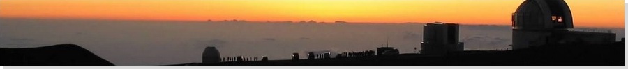
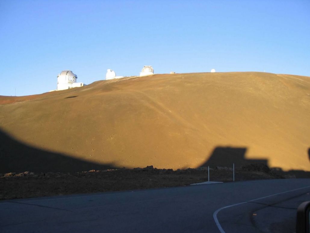
We piled into the tour bus, and started our journey. We drove north on the main highway out of town, across old and new lava flows, some marked with signs mentioning the year of the flow. There'd be a flow from 1975 next to one from 1890. Some lava flows were chunky and plants were growing in the cracks, while other flows looked like they flowed last week, black and barren as the moon. After 35 miles, we came to the junction of Saddle Road, nowadays state route HI-200. We followed Saddle Road another 35 miles until it gained the 6,600-foot saddle that connects the two Maunas, Loa to the south, and Kea to the north. The scale is too much to describe. The mountains are so gigantic that the land rises up in an even, unbroken manner. What looks like a 500-foot tall hill is really a 7,000-foot tall mountain mass. It's too big for the mind to fully grasp. View the photo at the left, and you tell me if that looks like 7,000 vertical feet of mountain in the background.
Saddle Road itself is a journey. In the old days, it was a measly track put in by ranchers and the military to connect Hilo on the east coast to Kona on the west. Otherwise, one is obliged to drive the circumference of the island, adding about 80 miles. Later, the track was paved, but in a very basic manner. The paved road was still narrow with hard shoulders. The military base up here would often ferry big trucks and armored vehicles using this road, so having meddlesome civilians in their little cars getting in the way is probably the real reason the road is closed to tourists. These days, the road has been improved so that it is up to normal highway standards. The long uphill drive from the coast to the saddle was enjoyable, the gradient lenient the whole way.
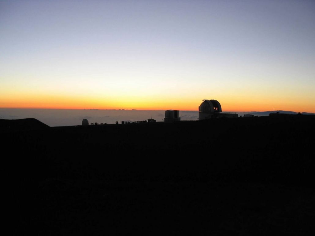
We then turned onto the steep road that wiggled another 3,000 vertical feet in six miles (a consistent 9.5% grade, with sections reaching 15%) to the Onizuka Vistor's Center. We rolled in here around 6 p.m. and milled around with the other handful of tour busses. There's a pre-determined time when the tour busses can start up the remainder of the road. It is not paved after the visitor's center. In time, it was our turn and we started up the road. Up this high, the mountain is basically rubbly rock and clumps of larger rocks. There is very little vegetation. Across the way was the unbelievable mass of Mauna Loa. Occasionally we'd stop for a few minutes while the driver talked about some formation or history. The convoy of tour busses arrived onto the highest roads and the observatories around 7:30 p.m. The shadows were long and at over 13,000 feet elevation, the air was near-freezing cold.
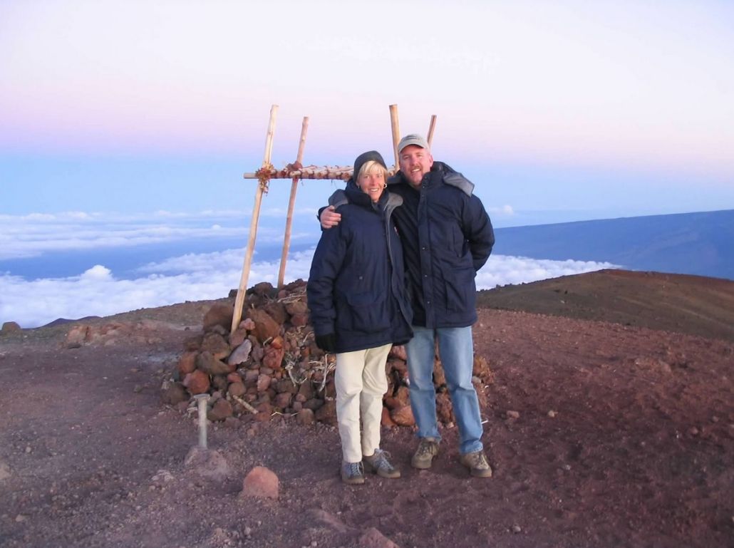
After another small delay, our bus started again. Normally, the busses all congregate on a long, flat open area slightly apart form the observatories, and everyone gets out for the sunset. At a bend in the road just before this congregation area, our driver pulled aside and the two of us scurried out to "climb" Mauna Kea. The summit of Mauna Kea is so massive you could fit a city up here. A number of small hills (called Pu'u) dot the broad summit, and it just so happens one of them, called Pu'u Weki'u, is higher than the rest. This would be what we'd actually climb.
The hike is short. We hopped over a small barrier and onto a well-beaten footpath down to a small saddle, losing about 100 vertical feet. We were sucking air and feeling the effects of suddenly being at 13,700 feet without acclimatization. The final leg of the hike was a 130-foot gain up the trail to the humble summit of Pu'u Weki'u, of Mauna Kea, and of all of Hawaii. There is a small structure up here, but no heiau. A few others were up here and one fellow kindly took a photo of us. We quickly descended and re-met our group at the congregation site, no more than a few hundred feet where we'd been dropped off. Our hike had taken us 20 minutes, and it was nearing darkness as we arrived with the others.
We had no qualms about doing it the way we did. We were having a thoroughly enjoyable day. I will say that in our rush, we both nearly fainted in the thin air up here. The sunset, yes, was remarkable. Our group then reboarded the bus for the drive down.
After descending down past the visitor's center, we drove off the road to a secluded spot for some star-gazing. It's not as if the observatory people would let us look through their scopes. But we had nifty $4,000 Celestron units that are fancier than anything I've ever played with, and definitely for the hobbyist. We spent about an hour looking at various objects including the Ring Nebula, Jupiter and the Jovian moons, some star clusters, a binary system, and other cool stuff which appealed to my inner nerd. From there, we drove back to Kailua-Kona, taking two hours for the drive, and arriving at midnight. A fun day and one I recommend if you might want to go with a tour group. We spent the remainder of our four days on the Big Island by visiting the northern Kohala Coast, and a fascinating and amazing day trip to Hawaii Volcanoes National Park, where we took a long hike across lava field to witness actual lava emerging into the ocean.
|


|