
The Mountains of California
www.surgent.net |
|
County Highpoints Caliente Mountain • Big Pine Mountain
These two peaks required almost 50 miles of hiking and biking to achieve. I was accompanied by Adam Helman, the first time we met. He would become a great friend before passing away in 2015.
Date: December 16, 2000
• Elevation: 5,106 feet
• Prominence: 2,206 feet
• Distance: 17 miles
• Time: 6 hours
• Gain: 1,165 feet, plus 1,000 feet when all ups and downs are added
• Conditions: Crisp and dry
• Partner: Adam Helman
California
•
Main
•
PB
When people think of San Luis Obispo County, they probably think of rolling grassy hills dotted with oaks, like from a Steinbeck novel. Or maybe they think of the ocean and the picturesque towns on the shoreline such as Morro Bay and Pismo Beach. Or perhaps they think of the inland cities of Atascadero and San Luis Obispo, with their pleasant year-round weather and rich history including a few of California's famous missions and wineries. Few likely think of stark desert, but this is what the eastern third of the county consists of, a little slice of central Nevada right here by the ocean.
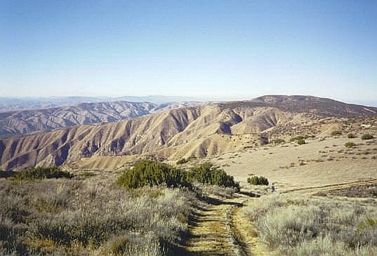
The county's highest point is Caliente Mountain, which rises above a desert plain known as the Carrizo Plain. The plain is rain-shadow desert, with a few dry lakes sitting in the lowest depressions. Few people live out here and almost no one ventures out this way unless they have business to attend to. Caliente Mountain is a long ridge that tops out at 5,106 feet, and during World War II, a lookout was built at the summit to watch for possible air attacks from the Pacific Ocean. Up this high, views are tremendous.
My first time in the area was in 1990. I accompanied a college friend to the Los Padres National Forest, hunting for feral pig. We came up the usual way, via US-101 and the scenic grass-and-oak valleys. The forest itself was a mix of trees and open areas. We hunted for a couple days with no luck, but the experience was a lot of fun.
Exiting, we got onto state route CA-58, heading east. The map showed we would get to Bakersfield this way. I was truly surprised just how big and how vacant the desert was out here ... and that there was one here to begin with. Like most people, it would not have occurred to me there is a bona-fide desert here.
We stopped for snacks at a small general store (note: I did not say mini-mart) in California Valley, the closest thing to a town out here. It was just a few buildings, a weak nexus for the scattered homesteads out this way. I recall the proprietor was a big guy with a scraggly beard. We continued east through the Temblor Mountains and the San Andreas Rift Zone, dropping into the Central Valley near McKittrick, thence to Bakersfield and on home.
I would not return for ten years. Adam Helman and I agreed to meet and hike this peak, along with Santa Barbara County's highpoint, Big Pine Mountain, also here in the general region. We planned to hike both peaks over two days. Caliente Mountain's "easiest" route requires 17 miles round trip, which is just a warm-up for the 32 miles needed to hike Big Pine Mountain. If successful, we'd be putting in nearly 50 miles over the weekend. We came prepared with bicycles.
I drove from Phoenix and 500 miles later, had located myself to the little town of Maricopa, about 45 miles southwest of Bakersfield. The town is tiny, just a few hundred people. But it does have a decent hotel, the "Motel 9". This is where I stayed the night. Early the next morning, Adam drove in, and we met one another for the first time. He transferred his gear into my truck, parked his car here at the hotel, and we were off.
From Maricopa, I drove us west along route CA-166 to Soda Lake Road, then northwest on Soda Lake Road through the foothills, emerging onto the Carrizo Plain. At first, the Carrizo Plain was socked in with heavy fog. The road itself was unpaved in segments, but there was no one else up here except for us. I stayed on Soda Lake Road for 29 miles to the turn off for Caliente Mountain. The fog dissipated as the sun rose.
From Soda Lake Road, I followed a steeper service road to the range crest, the last mile rather steep on exposed shelf roads that in wet weather would be treacherous to drive. Once at the range crest, I parked near a substantial gate. We were eight miles from the summit. The road goes most of the way to the top, but the gate kept us from driving farther. We started our trek at 9 a.m.
The first two miles of road was pretty good, clearly maintained on a regular basis. We came to the top of one ridgepoint where some workers were there, erecting a new tower. They had driven up from a different location, and were surprised to see us. After that, the road's condition grew worse. In another mile and a half, we came to a wrecked trailer in a clearing, apparently an old ranch-hand residence from years ago. We were about halfway to the top.
The farther we walked, the worse the road became. It essentially petered out into a footpath after two more miles, passing by a helicopter landing pad where we stashed our bicycles. The road then dropped and for the remaining couple of miles, worked its way up and down intervening ridge points until finally emerging to the summit. We arrived here at 12:15 p.m. in clear conditions.
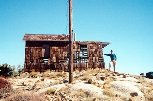
The building up top is (was) a fascinating historical relic from the World War II days. It may seem silly to worry about an air-invasion from the Pacific, but just to the east were the big oil fields surrounding Bakersfield. Those would have been an attractive target for an invading enemy. When we arrived, the building was barely standing, basically staying erect out of habit. It would creak in the wind and was completely unsafe. Nevertheless, we explored around it and took a one-hour break on the summit, happy to be here and admiring the views in all directions.
We started walking out at 1 p.m., picking up our bikes and riding the downhill segments whenever possible. We exited in less than two hours, riding out most of the last four miles on the good service road. We were back to my truck at 3 p.m., which amounted to a six-hour day --- the bicycles certainly helped cut off a lot of the time. After reloading the truck, I inched us down to Soda Lake Road and back to state route CA-166. Instead of returning to Maricopa, we drove west and south on route CA-33 to situate ourselves near tomorrow's big hike, Big Pine Mountain. Being so close to the Winter Solstice, the sun set early this time of year. We were already into dusk as we rolled into camp at the Willow Campground.
The old shack finally collapsed, probably in 2012 or early 2013. I found an interesting report with photographs of the old summit structure. Also, the trailer at the four-mile mark has also decayed into a heap of metal too, judging by his photographs. I wish I had taken more images while there but this was back in 2000 when digital was still very expensive and I wanted to "conserve" my film. Those were the days.
Date: December 17, 2000
• Elevation: 6,800 feet
• Prominence: 2,160 feet
• Distance: 32 miles
• Time: 12 hours
• Gain: Over 5,080 feet when ups and downs are included
• Conditions: Nice, but chilly
California
•
Main
•
PB
Big Pine Mountain is a remote mountaintop in northern Santa Barbara County. It is the highest peak of the San Rafael Mountains and is protected within the Dick Smith Wilderness of the Los Padres National Forest. A road goes near the top, but this road is gated sixteen miles away, so a round trip journey covers 32 miles. The one-way net gain is over 3,400 vertical feet net, but with many drops and regains along the way. My figure above of 5,080 gross feet is conservative --- it may be as high as 5,400 feet. We were looking at a dawn-to-dusk effort at a minimum.
From state route CA-166, we followed a series of rural roads and situated ourselves at the Willow Campground, a basic camping area northeast of Big Pine Mountain. Not surprisingly, we were the only people here. The night was freezing cold. I slept in the open in my truck's bed, and when I awoke around 4 a.m., my biv-sack was covered in a layer of frost.
We drove about a half-mile to where the road is gated. I packed everything up, locked up the vehicle, and we were hiking at 5 a.m., walking past the gate, along with our bicycles. The morning was uncomfortably cold, but clear and calm, with a half-moon offering enough light to navigate by. Our starting elevation was 3,440 feet.
In two hours, we had covered four miles and gained over 1,800 feet to arrive onto the Santa Barbara Potrero, an elevated meadow at 5,300 feet elevation. We took a break here. Being so close to the Winter Solstice, these being the shortest days of the year, the sun was only now breaching the eastern horizon. It was brighter now, clear and calm, but still very cold, a shade above freezing. At the Potrero, Big Pine Mountain Road branches south.
The first mile of this road was downhill and smooth, so we rode it on our bikes, covering it in 10 minutes. The next mile was uphill, gaining 400 feet in a mile, which we walked. After that, we had two more downhill miles, but the road was rutted enough that we walked most of it. Still, we covered this four mile segment in about 90 minutes, arriving at a lowpoint, elevation 5,203 feet according to the map, eight miles from the trailhead. This point is about a mile north of Chokecherry Spring. We were pleased with our pace, having covered half the distance to the peak already. Conditions were still cold, but with the sun up, not as chilly. It was a clear and calm day so far.
We could see the road continue south, making a long sweeping traverse to achieve a notch where the Madulce Trail comes to meet it. This point was another three miles away and about 800 feet higher. The road was in pretty good shape, but we walked much of it. A real mountain biker would probably have no problem on it, but we wanted to conserve our energy whenever possible, and for us, walking was more efficient. This segment took us another 90 minutes.
We arrived to this notch at about 10:30 a.m. and took another rest break. We had covered 11 miles with another five to go. So far, things had gone very well. We were moving at a good pace, the weather was agreeable, and I felt more energy than I probably should have felt after covering 11 miles. While we were relaxing, two men on horseback appeared. We had a chat with them, then they went on their way. They would be the only people we'd see all day.
The remaining five miles broke down into two segments: a one-mile, 500-foot descent to the Alamar Guard Station, then a four-mile, 1,200-foot ascent to the summit. We debated whether to bring our bikes. The road down to the Guard Station was rocky, so riding it was not an option. We decided to stash the bikes in the bushes here and walk the remainder.
The downhill hike went quickly. The Alamar Station was just a simple shack, and no one was home. The hike to the summit also went fast, the road being better here. We were in heavy pine forest, pine cones on the road, some as big as a football, and heavy. We were mindful that if one fell on us, it could be bad news. We just hoped one would not.
A scant side track branches off the main road and leads to the summit. At 12:15, we arrived on top, the culmination of 16 miles and over 7 hours of hiking and bicycling, although just two or three of those miles was done on the bikes.
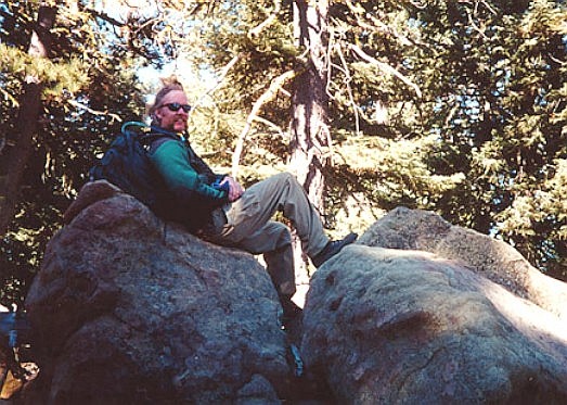
The summit is broad and open, ringed by the big pines, but also allowing for distant views. We could see the Channel Islands and the Pacific Ocean, along with a lot of forested ridgetops. The temperature up here was still cool, in the 40s, but clear with no breeze. We lucked out with the weather today. Any rain, fog or breeze could have made this a miserable slog. We spent about thirty minutes wandering the top, tagging any rock outcrops that could be the highest point.
Now for the hike down. It was sobering to contemplate that we had 16 miles to cover, with sunset about four hours away. We moved quickly. Not running or jogging, but with a steady fast walking pace. The hike down to the Alamar Station took an hour, and another 30 minutes to the Madulce Trail Junction and our bicycles. It was 2:45 p.m. now. The sun was lowering to the southwest, creating long shadows. In the shade, the temperature would drop 10 degrees.
We did not really stop for a break here. We unstashed our bicycles and only now would they pay their dividends. Sunset was less than two hours away and we had 11 miles to cover. To now, we had covered 21 miles, of which 18 of those were by foot.
The roads, thankfully, were in decent shape. I mounted my trusty steed, pointed it downhill and let gravity handle the rest. I rarely pedaled, and mainly just governed my speed with the brakes. We weren't moving terribly fast by bicycle standards, but we were able to cover the three miles to the 5,203-foot lowpoint in twenty minutes (doing the math, that comes out to a whopping 9 miles per hour on the bike).
The four mile segment back to the Potrero took a little over an hour. We biked what we could, but walked most of it due to the road's rocky and rutted condition, and that most of it was uphill. It was now roughly 4:30 p.m.. The sun was low and the land was now mostly in shadow. The temperature was dropping fast.
The remaining four miles back to my truck took just 30 minutes. The road was mostly in good shape and we were able to ride virtually the entire four miles out, arriving back to my truck at nearly 5 p.m. on the nose. By now, the sun had essentially set. It was not completely dark, but getting there. We were done! Big Pine Mountain was now ours to claim, and that felt exhilirating.
But we weren't exactly done. Neither of us had any desire to be stuck here any longer than necessary. We didn't lollygag, shake hands and congratulate ourselves. We got off the bikes, stowed them in my truck, got whatever else we needed to get done taken care of, got into the truck and hustled out of there. By now, it was dark.
To say I was exhausted is an understatement. I was thrashed, but also feeling pretty damn pleased. We had covered 32 miles today, roughly 20 by foot, 12 by bicycle. Without the bikes, we were easily looking at another 4 or 5 hours of hiking. There'd be no way we could have done that without coming out near midnight. The bicycles were critical to our success.
The drive back to Maricopa took about an hour. Adam had parked his vehicle at the Motel-9 in town early yesterday morning, where I had stayed at the previous night before we first met up. Adam had not cleared it with the owner, so when we got back, the owner was upset at us, explaining that he had to call it in as a matter of due diligence. Somehow, Adam's family were notified and they assumed the worst and had called out for Search and Rescue to come save him (and presumably me, I am not sure). It took a lot of apologizing from both of us, and a lot of talking by Adam to the owner, his family, and even the sheriff's people, to calm everyone down.
After about 30 minutes of this drama, everyone had mellowed slightly. We transferred Adam's stuff from my truck to his car, and only then congratulated one another for a successful weekend of bagging two peaks, covering 48 miles. Adam got moving soon thereafter.
I was extremely tired and had no desire to start driving anywhere. My plan for the next day was to drive toward the Bay Area to visit my sister. Since I was already standing in the parking lot of the Motel-9, I asked the owner if I could get a room. He was cool. He understood, once it was all explained, that it was a judgement error to leave the car there without permission. My dinner was whatever I could scare up at the nearby mini-mart, and I was fast asleep not long thereafter.
The next day, I began my drive north to the Bay Area. Up next: San Benito Peak in exciting San Benito County, home of the insane dobermans...
|

|