
The Mountains of Washington
www.surgent.net |
| Mount Constitution |
• Orcas Island • Highpoint: San Juan Mountains • Highpoint: San Juan County |
|
Date: July 22, 2004
• Elevation: 2,407 feet
• Prominence: 2,407 feet
• Distance: 7 miles
• Time: 4 hours
• Gain: 1,500 feet
• Conditions: Stunning
Main
•
PB
Mount Constitution is the highest peak of the San Juan Islands off the northwest coast of Washington. Four of the bigger islands form into San Juan County, and thus, Mount Constitution is the county's highest point. The peak lies on Orcas Island, which is the "main" island of the chain, in that most people who live on these islands live on Orcas Island. Regular ferry service goes between Anacortes (on the mainland) and Orcas Island.
We were visiting Washington as part of a two-week driving holiday. We were attending the National Highpointers convention in Puyallup. Our journey had started in Reno, Nevada, and included stops at various points in California and Oregon. A couple days ago, we were touring the Mount St. Helens area, which blew up back in 1980. Some of the hills here were formed as a result of that eruption, so yes, in this case, we were older than the hills.
So now we were in the Seattle area, and ready for some more hikes. We wanted to go out to the islands, so hiking Mount Constitution was the obvious excuse to go there. We stayed a night in Anacortes, so that we would be close to the ferry that left for Orcas at 5:30 a.m. the following morning. Getting to the ferry was no problem, and we were the last ones on for this ferry, saving us an hour wait. The ride took about an hour to Orcas.
San Juan County is composed of four large islands (Orcas, Shaw, Lopez and San Juan) and many dozens of smaller islands bunched together in the Puget Sound. These islands are set apart from the Washington mainland and are (geographically) more sensibly grouped in with the big island of Vancouver, which belongs to Canada. I wondered how the international boundary between Canada and the United States was figured, since there seemed to be any number of options to split the island groups.
The boundary was established in the 1870s after tensions between American and British-Canadian settlers escalated after a pig belonging to one Brit-Canadian settler rooted through the garden of an American settler in 1859. The American shot the pig, setting of a chain of events that led to armed forces being brought in to stare one another down (this, the so-called "Pig War"). The border agreement that gave the islands to the United States was negotiated over a period of years and formally established in 1871.
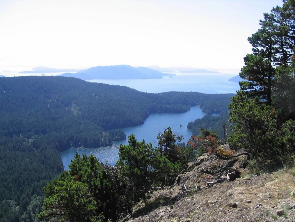
Once in Orcas, we exited the ferry and drove toward Moran State Park, passing through the village of East Sound where we got pastries and drinks. Arriving at the park, we paid our day fee and parked in a dirt pullout near Mountain Lake. The paved road actually goes all the way to the top, but we wanted a hike, so we chose this option. Mountain Lake is popular for fishing, and there's enough room for parking, and a good trail leads from here to the top. Mountain Lake includes a small islet, which means that it is an island on a lake on an island in the ocean.
We started at the Mountain Lake Trailhead beside Mountain Lake, elevation 917 feet. The trail heads north along the lake and stays level for the first 1.4 miles, then comes to a junction where we turned left up towards Twin Lakes, 0.8 mile away and 200 feet higher (staying straight at this junction would have kept us circumnavigating the lake, which is apparently a popular hike itself). Because the route was mostly flat, we covered the 2.2 miles to Twin Lakes in just over a half-hour, and barely had broken a sweat. We were hiking in thick old-growth forest, and at one point along the trail we came upon a huge root-ball of a long-ago fallen tree. The root ball was about 10 feet in diameter and looked like a medusa-head of snaking root veins.
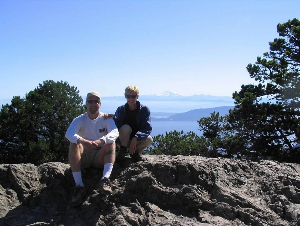
We took a break at Twin Lakes, then we continued, going left and following the signs (and the trail) to the top. The summit was just about 1.5 mile ahead but almost 1,300 feet up. The trail was consistently steep: never too bad but never lenient either. We marched and took a couple of breaks, and actually made faster progress than we originally thought. Finally the trail, which had stayed mostly on the mountain's east face, swung north then west, coming up and meeting the paved road just below the summit. We walked the road the final few feet to the top, a broad, rocky bald area topped by a 30-foot tall stone lookout tower constructed in the 1930s.
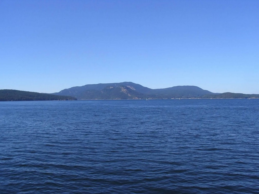
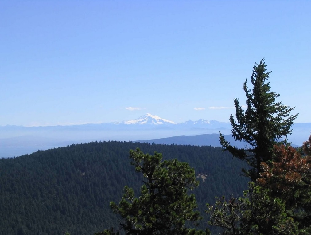
From the summit, the dry air allowed for completely unobstructed views in all directions: Mount Baker was visible about 70 miles to the east, while Mount Rainier's huge mass was visible way off in the southeast, about 120 miles away. The Olympics were close enough to our southwest to see detail of the ridges. The views down over the water were great, with gobs of islands in view.
We stayed for about an hour, and during that time numerous people had driven up. Two little boys about 7 years old had squirmed their way past the rock wall at the viewpoint and were literally playing on the cliff's edge until I went over to tell them to get back from the edge (I was closest to them). Where were their folks? No idea. A whole group of girls about 13 or so showed up and did some impromptu cheerleading. It was an interesting crowd. It was nice, however, to have restrooms and trash bins at the summit. We lightened our loads by tossing away our garbage rather than carry it all down.
Coming down, we followed the Little Summit Trail that heads south and stays high on the ridge. In many areas we had unobstructed views over the islands below as we walked. The Little Summit trail runs for 2.2 miles to "Little Summit", but only loses about 200 feet, so it was mostly level. Actually, we left this trail about 0.1 mile before Little Summit and followed a steep trail directly south back to our car at the trailhead. This trail was not shown on the topo map and was rougher than the other trails, but it was easy to follow and descended fast. In less than an half-hour, we'd dropped over 1,000 feet, coming out to the camping area about a quarter-mile from our car, to which was an easy walk. Our loop covered 7 miles with just under 1,500 feet of net gain.
We rested back at the car, then drove out, driving to a little restaurant in West Sound where we had a lunch. At about 2 p.m., we got our car in line for the 4 o'clock ferry back to Anacortes at Orcas. We used those couple of hours to walk around the tiny community of Orcas and rest on the grassy slopes of a nearby park. We were back in Anacortes by 6 p.m.
The San Juan Islands would seem to have numerous places to explore and if we had the time we probably would have stayed longer. Even so, we thoroughly enjoyed our day on Orcas Island and the hike of the peak. I would highly recommend to go slow and make a day out of any trip to the islands. The vagaries of the ferries are going to slow you down anyway, may as well roll with the punches.
|
|