
Peaks & Highpoints of Virginia
www.surgent.net |
| Mount Rogers |
• Highpoint: State of Virginia • Highpoint: Grayson & Smyth Counties • Appalachian Mountains • Jefferson National Forest |
 Tame horses live beside the trail
|
Date: May 25, 2000
• Elevation: 5,729 feet
• Prominence: 2,449 feet
• Distance: 8.5 miles
• Time: 4 hours
• Gain: 1,070 feet
• Conditions: Misty and rainy
Main
•
PB
I was on the second day of a five-day tour of state highpoints in the southeast. I had flown in to Atlanta early yesterday and had success on two state highpoints the same day: Brasstown Bald in Georgia and Sassafras Mountain in South Carolina.
Yesterday day had been humid but pleasant ... that is, until I arrived in Asheville, North Carolina. The storms were intense and the sky black, and it was still in the middle of the afternoon. Foolishly, I tried to visit Mount Mitchell, the North Carolina state highpoint, but after encountering dense fog while on the Blue Ridge Parkway, I turned around and retreated into Asheville. I planned to try again the following morning, so it made sense for me to find a place to stay in town.
It rained heavily with lightning and thunder all night. The next morning (today), the clouds were still in abundance and there seemed to be no let-up to the action. From my hotel, I could see the clouds billowing over the mountain range above me. I can't imagine how awful it was up there at the moment, and that was my destination. Well, no it wasn't any more, at least for a few days. After watching the Weather Channel, it seemed the storms were concentrated in this part of the country, while up north it seemed less intense. So I rolled the dice and ventured north toward Virginia now, instead of waiting until the end of my trip, as was my original plan.
The drive from Asheville to the Mount Rogers area took a couple hours, since I followed a circuitous route to avoid the worst of the weather. Along the way, I came across trees down in the road, downed tree limbs and leaves, and general small-scale damage, but nothing widespread like a tornado might cause. When I arrived into the parking area for Mount Rogers at the Grayson Highlands State Park, it was slightly after noon and still gloomy, but not nearly as insane as it was down in Asheville. I parked and got my pack in order, including my parka. From where I was parked, the one-way distance to the summit was about 4.25 miles, much of it along the Appalachian Trail.
The initial portion of the hike went through grass meadows and woodlands, with tame horses standing around, amenable to a pet on the snout. Shortly, the side trail I was on merged with the Appalachian Trail. There were a few hikers out today. Most of them were like me, having parked at the nearby parking lot for a dayhike. A few were through-hikers, looking like they'd been out on the trail for weeks. The actual hike was mostly level, with easy gradients up and down. In a few places the trail passed by interesting rock formations. Overall, despite the grayness, it was very lovely.
Later on, I caught up to a girl hiking with her dogs. She was doing a three-day loop back-pack in the immediate region. We hiked for about a mile, coming to a trail junction and a couple of lean-to shelters, where a number of other hikers had stopped and congregated. This was the junction for the spur trail to Mount Rogers' summit.
From here, I went off on my own, hiking the remaining mile up more easy grades toward the forested summit. In about 20 minutes, I was on top, seeking out the highest point amid rock piles and underbrush. I was able to get a self-portrait with my camera's timer, and I stuck around for a few minutes, but soon, started my way back down.
The hike back out went quickly and the weather even improved, now becoming a mix of sun and puffy clouds. I was back to my car around 5 p.m., and despite it still being humid and mildly gloomy, it had not rained once during the hike. My gamble had paid off. This hike was very pretty and I enjoyed every minute of it.
From here I drove west to visit Black Mountain, the state highpoint of Kentucky, before the sun set.
Date: May 25, 2000
• Elevation: 4,139 feet
• Prominence: 1,899 feet
• Distance: 0.1 mile
• Time: 20 minutes
• Gain: 20 feet
• Conditions: Generally cloudy
PB
I had just completed a four-hour hike up Mount Rogers earlier today. Storms delayed me so that by the time I finished that hike, it was past 5 p.m. I hoped to visit Black Mountain before darkness fell.
The roads and the scenery in from Virginia was lovely. Seams of coal could be seen in the rocks lining the roads. By 6 p.m., I had entered Kentucky, the state line sign barely readable after being shot a few times with a shotgun.
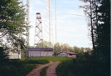
The access road to Black Mountain is nearby, and I drove this road to the top, which is flat and features buildings including a large "golf ball" radar dome run by the FAA. The actual highest point is near a lookout tower behind a gate. I hiked to it, tagged all that looked high, and returned to my vehicle.
The whole area was in sad shape with trash everywhere. People evidently come up here to drink, shoot and mate, judging by the things I found on the ground (and holes in anything vertical). However, while I was here, there was no one around. I didn't stay long, and returned back to the highway and into Virginia. I stayed the night in Kingsport, Tennessee.
|


|