The Mountains of Utah
• www.surgent.net
|
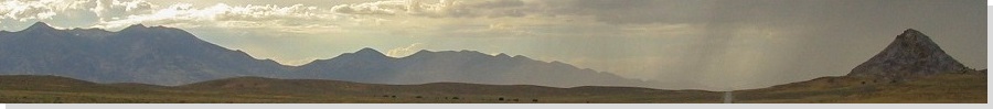
| Delano Peak |
• Highpoint: Beaver & Piute Counties • Highpoint: Tushar Mountains • Fishlake National Forest |
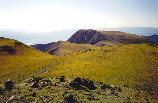
 View of the summit from high on the main ridge
|
Date: September 2, 2001
• Elevation: 12,169 feet
• Prominence: 4,689 feet
• Distance: 10 miles
• Time: 5 hours
• Gain: 2,200 feet
• Conditions: Clear
Utah
•
PB
Yesterday, I drove in from Nevada and hiked a couple easy peaks, ending the day with Brian Head Peak. By the time I was off of Brian Head Peak, it was late afternoon, so I descended the highway into Parowan, drove north an hour into Beaver, and stayed the night at a hotel. Early the next morning, I drove up state route UT-153 about 20 miles to the Elk Meadows Ski Area, arriving to the trailhead at 6:10 a.m. in pleasant weather.
The trail starts on the north side of UT-153 and goes into the forest a half-mile where it meets up with a trail coming from Puffer Lake. Not far after the trail junction, the main trail is blocked by deadfall. At first it was usually a single tree, which could easily be stepped over or around. But doon, there were piles of dead trees in the trail, forcing me to hike off-trail for awhile. The trail eventually rises to the top of a short ridge at about 10,400 feet elevation. At this point, I'd covered just over a mile from my truck.
The next half-mile was unpleasant, too. Now, the deadfall was man-made. There was dead crud everywhere, with bulldozer tracks in all directions. I think they were clearing the area for a future ski run. I'm always amused how bugly ski areas are when not covered in snow. Finally, I was past all this deadfall junk and the ugliness and back on the main trail in the trees. For the next portion, probably a shade less than a mile, the trail gained at a pleasant grade in the forest on the west flanks of Lake Peak. It then crosses a stream and comes out in the open again. It was getting prettier.
At this stream crossing, I followed a faint path to a couple of junctions. My goal was the Skyline Trail. However, I missed an important switchback (the morning sun's glare was intense ... that's my excuse). But in the openness, I could see my immediate goal ahead: a small pass at 10,900 feet elevation directly southwest of Mount Holly, the big peak south of Delano Peak. As I hiked toward this pass, I re-found the trail, and followed it over the pass. On the other side, the trail dropped about 100 feet, went through a couple stands of fir, and then crossed two wooden footbridges. After the second bridge, about 2.5 miles from the start, I began the long cross-country segment of the hike.
I hiked up a drainage that's shown on the map near an obvious left turn in the trail, between the words "Pack" and "Trail" on the map. This part was straightforward. After a few minutes, I was high enough to make out the main route. I had to cross a couple of boggy sections, and I hiked up and across the grassy mountainsides toward a parallel drainage just to the north of the first one. This second drainage is below a long ridge that tops out at 11,526 feet. This is all above tree-line and it is all clumpy grass and lovely wildflowers.
The second drainage has a rudimentary trail, probably a game path that has been used by humans over the years, on the right hand side of the drainage as one looks up. I followed it, then crossed the drainage to the other side at a convenient spot and started walking up the slope below point 11,526. Mount Holly, at 11,985 feet, stood high to my right. My goal was a small pass located between point 11,526 and point 11,815 northwest of Mount Holly. I stopped and turned around periodically to check out the awesome view, as well as to memorize landmarks for my hike down. I also made an extended stop high on the grassy slopes just to relax, for about 20 minutes. The weather was nice, with temperatures in the 60s, and a light breeze. Soon, I was on my way and I arrived to the pass shortly. For the first time, I could see Delano Peak.
At the pass, I continued level toward a ridge, steadily getting closer to Delano's main mass. Surprisingly, I found a very good trail for this final part. This trail stayed on the ridge, allowing for views down the east and west sides of the range. It rose and fell over two minor bumps, then bottomed out at a saddle below Delano Peak.
Here, the trail continued up the steep scree slope. It looked intimidating but aside from a small 20-foot stretch of really loose crud, it was safe and solid. This small section gained about 200 feet quickly, and topped out above rocky outcrops and below a false summit. I saw two mountain goats in the area, covered in their fine fur, munching on the grass.
At this point, I ditched my pack and walked up the false summit, from which I could see Delano Peak about 500 feet away. It was an easy walk to the top, and I arrived at 9:15 a.m., exactly 3 hours after I started. It was beautiful, with incredible views in all directions, including the bare rocky slopes of Mount Belknap to the north.
I stayed for 15 minutes and just relaxed in the cool breeze. I signed into the register, but a wooden sign described by many apparently is no longer there, as I could not find it. Up to this point, I had clear skies, but a couple of puffy clouds started to appear so I figured I should get started down.
I followed the same route down as I did up. Going down was quick as the footing on the grassy slopes was solid, and in less than an hour I was back to the wooden footbridges. I continued to make good time along the trail, but of course, was slowed by the downed trees mentioned earlier. Actually, I did okay, but I stayed too high and found myself about 100 feet above the trail, which I could view from my forested perch, so I downclimbed to it and was back to my truck at 11:15 a.m. From here, I stopped in Beaver for lunch, then made the 250-mile drive back to Henderson, Nevada, to shower up and visit with the folks.
|
|