County Highpoints of Texas
www.surgent.net |
|
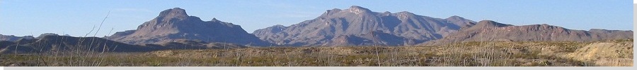
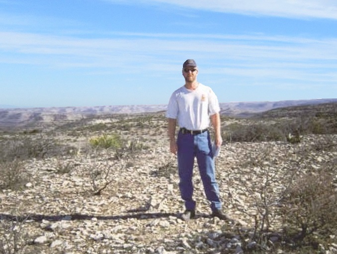
King & Castle Mountains • Ninemile Ranch Mesa I spent a few days on my Spring Break from teaching in March 2002 visiting various county highpoints in Texas. Bob Martin joined me for the first couple of days. We concentrated our efforts on the lower Pecos River areas, then headed north and east and tackled a bunch of easy, and some not-so-easy, highpoints up on the Edwards Plateau. Some of the county highpoints were actual peaks that required effort, some were simple drive-ups in a pasture. Weather was generally good, a little on the warm side. The highlight was me getting a flat tire in the middle of nowhere. I garnered 16 county highpoints total. Below are summaries of the more scintillating ones with photos. I was often gently surprised how pretty some areas were, I guess not having high expectations to begin with. We had no issues with landowners, and were able to gain permission for the trickier privately-owned ones. Out this, way, there just aren't many people to run into to begin with.
Date: March 10, 2002
• Elevation: 3,141 feet
• Prominence: 351 feet
• Distance: 2 miles
• Time: 2 hours
• Gain: 250 feet
• Conditions: Calm and pleasant, a little overcast
Texas
•
PB
•
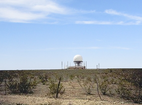
FAA Radome Site
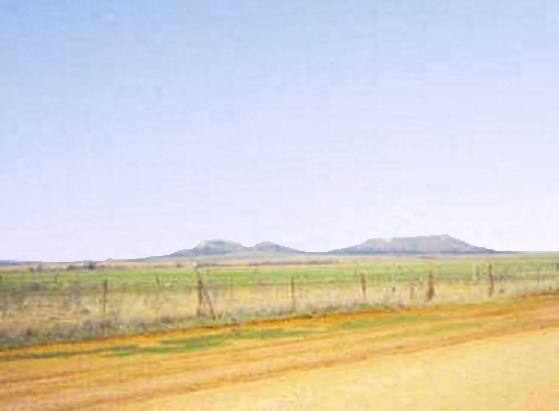
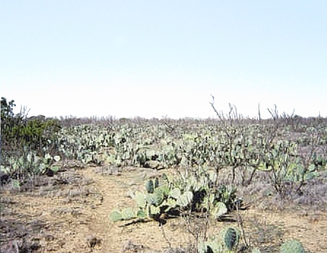
The highpoints of Upton County is a tie between two mesas, called King and Castle Mountains. Both contain spot elevations of 3,141 feet. King Mountain is home to a FAA radar dome.
From the city of Crane, I proceeded south on US-385 to Castle Gap Road, then east aiming for a gap between the two mesas. However, I came to a locked gate a few miles short of the goal, and too far out to walk. So I retreated back to the highway.
I drove north to Ma Earp Road, then east and south, arriving at a ranch property below King Mountain. I could see the FAA dome from the road. There were people in the area, so I parked at the gate, hopped it and walked in to greet them.
An older gentleman was hitching his cattle trailer to his truck when I caught his attention. I introduced myself, showed him my map and explained what I wanted to do. At first he seemed skeptical, but after a few minutes he warmed to me and granted me permission. He introduced himself as Mr. Sanders. As thanks, I helped load some items into his truck.
He opened the gate for me and allowed me to drive the FAA access road to King Mountain's flat top, almost near the FAA facility. He drove with me in his own truck, planning to locate some of his cattle. He explained that the FAA facility is actually on another guy's land, but he didn't mind me walking to it. He also gave me information on the roads to Castle Mountain, including the combination to the gate so I could let myself out. Here, we parted, he on his way to find his lost cattle.
I parked short of the radar dome and walked the perimeter. I kept my visit short. I found what looked like a kicked-over cairn, but didn't linger. Back to my truck, I exited down the mesa, then along ranch roads a mile or two to locate myself below Castle Mountain. A couple hunters were sitting around having a lunch. They didn't seem to mind me being there.
The hike to the top of Castle Mountain was short but strenuous. I barged directly up the slopes to the base of a small cliff band, then scampered through a weakness to attain the flat top. I walked the top for about 20 minutes in a cross-hatch pattern, forced by the lay of the land to complete this one "statistically". The brush is too thick and the land too flat to be able to eyeball any actual highpoints. I exited via the locked gate that Mr. Sanders had given me the combo to, and left a letter of thanks folded up into a space near the lock. I wonder if he got it.
Date: March 11, 2002
• Elevation: 3,765 feet
• Prominence: 65 feet
• Distance: 1 mile
• Time: 20 minutes (hike), 2 hours (whole journey)
• Gain: 200 feet
• Conditions: Calm with blue skies
• Teammate: Bob Martin
PB
Terrell County straddles the confluence of the Rio Grande and the Pecos River, along Texas' boundary with Mexico. The land here is high desert cut by an intricate mazework of canyons. Most of the topography goes down, there being very few hills of any size. However, along the county's west border, there are low mesas of which one is the highest within Terrell County.
The county is remote, the closest "kinda" large city being Del Rio. There are roughly a thousand people in the county, most in the county seat of Sanderson, which lies within the canyons that drain into the Pecos River. Its location makes it prone to flash floooding, including a devastating flood that occured on June 11, 1965.
The other towns are Dryden, Pandale and Langtry, but they are tiny places, just a few dozen people at most. Dryden was (and is) an old train siding, while Langtry is where famous Judge Roy Bean lived for many years. Terrell County was the setting for the Oscar-winning movie "No Country For Old Men". The movie was shot in and around the county and greater region. I appreciated the fact they did not take the lazy route and shoot the desert scenes in Southern California, since "no one would know the difference". Yes, some of us would.
The highpoint is far from everywhere and not near any convenient roads. It was too far for me to gamble and drive all that distance, hoping to "get lucky". I'd need permission before committing to the drive. So one winter morning in early 2002 with not much going on, I got on the horn and started calling various county offices in Sanderson. The county clerk referred me to the tax appraiser, who actually knew the landowner personally. That was a stroke of luck. He gave me the man's name, a Mr. "M" who lives in Amarillo. I wrote Mr. M a letter, sent some maps and was pleasantly surprised to receive an affirmative response. He gave me the contact name of the ranch manager in Fort Stockton, whom I would contact a few days before we were to show up.
I drove from Arizona to Van Horn two days ago, then spent yesterday visiting a handful of county highpoints in the Midland area. I spent last night in Fort Stockton, then awoke early today, drove through Sanderson and then west along US-90 to the Terrell-Brewster county line sign. I parked and waited for Bob Martin, my trusty companion on many previous trips. He rolled in a few minutes later. Not long after that, the ranch hand, Jody, rolled up. He let us on the property.
We followed Jody north through a few gates, coming to a point where he left us to attend to his duties. He pointed out the road we needed to follow. We shook hands and thanked him. Then I parked and rode with Bob. We rumbled east and north another three miles along marginal ranch tracks, parking near a stock tank south of the highpoint.
We walked along a bulldozer track north a half-mile, then up to the highpoint, all this in about 20 minutes. The top was bare and stony with low desert scrub, grass and cactus. A derelict fence cut across the top but was mostly in disrepair. The views were good in all directions, mostly of flat desert to the east and bigger hills and mountains looking west. We spent a few minutes up here, then hiked back to Bob's truck.
From here, we went back to my truck, then drove out, going through the unlocked gates (locking them behind us) back to the main highway. In all, the whole journey lasted 90 minutes when driving times were included. My thanks to Jody, the ranch manager Pat, and Mr. M for their cooperation. I never actually talked with Mr. M when I called his offices but his secretary explained they often allow hunters on the property so having outsiders come on for a visit was not unheard of, although we were the first to visit it for the county highpoint aspect, which I think intrigued her, and probably Mr. M too.
We spent the remainder of today figuring out access onto the Glass Mountains in Pecos County, which we did in waning daylight. That's a whole story unto itself and entirely the result of Bob's charm and tenaciousness in tracking down landowner approval.
Date: March 11, 2002
• Elevation: 5,472 feet
• Prominence: 172 feet
• Distance: 2.2 miles
• Time: 90 minutes
• Gain: 600 feet
• Conditions: Windy and dusty
• Teammate: Bob Martin
PB
The Glass Mountains spread across Pecos and Brewster Counties in West Texas. The range's summit is somewhere in Brewster County, while an unnamed peak about a half-mile inside the Pecos County side is the highest point in Pecos County. Bob Martin and I spent the better part of the day securing permission to hike the peak legally. We got lucky, but ended up hiking it at sunset, emerging in the dark.
We started the day hiking the highest point in Terrell County. From there, we continued west into Marathon, then north along highway US-385 to the road that gets closest to the peak. Not surprisingly, the road was gated. Foot-high letters spelled out Brooks Ranch. This was a lead. However, we had a stroke of good luck: the gate was open.
We decided that I would stay back on the highway while Bob drove in to meet the landowner and see about hiking the peak. In case anyone drove up while Bob was in there, I could warn them to not lock him in. Bob was gone for about a half-hour. When he returned, he had no news. No one was home. We both decided against driving in on our own for fear of being locked in.
Next, we drove north and entered onto an adjacent property, encountering an old, grizzled-looking fellow. He was friendly and knew who owned the land. He even gave us his phone number. The landowner lives up in Odessa. We tried calling from our cell phones but reception was spotty. We decided to drive back south and bide our time in Marathon.
We spent the next couple hours in Marathon. Bob called the number and at first, he was told the man was in a meeting. So we had to wait. In the meantime, we walked around and tried to stave off boredom. The wind was picking up, strong enough to kick up dust clouds and blow tumbleweeds. Finally, Bob got through to the man and he gave us permission. He told us his son would be staying the night at the property and to meet him at the gate. So Bob and I drove back north and waited beside the gate.
The son showed up around 4 in the afternoon, as had a ranch-hand who wondered what we were up to. We all greeted one another, then convoyed along the ranch road to the house, where we had a chat. The son was a college-age kid and seemed cool. We finally departed and drove a rough ranch track another mile roughly west to a flat bench of sparse juniper, parking beside a fence at 4,800 feet. We started our hike at 5 p.m.
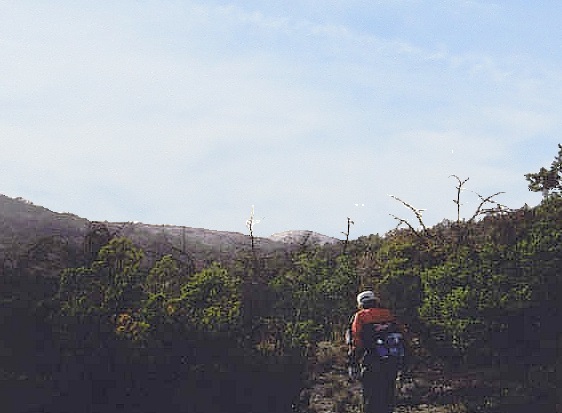
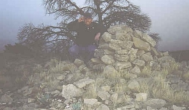
From the vehicle, we went northwest through scrubby juniper forest and weedy brush. The going was slow. We had to cross through a narrow drainage, which we avoided by staying high on the hillsides, hiking by sight toward a peak, elevation 5,360 feet according to the map. This wasn't our highpoint but it was close. Past the drainage things opened up, and we made our way up the hillsides a couple hundred feet, working by sight to the summit. All this is about an hour of hiking, covering a mile and 600 feet of gain.
A large cairn marks the summit, looking like one of those famous Basque sheepherder cairns. Some contending bumps on the ridge line were quickly ruled out by observation and sight-level. The wind was fierce, with gusts up to 40 miles per hour. We stayed in the lee of the wind, got a few photos, but didn't linger as it was getting dark. The hike out went fast, the only event being Bob walking into an agave plant and getting shin daggers.
We made our way up the drainage again to the elevated juniper bench where Bob's truck was parked, but now we had near darkness. The junipers were thick enough to prohibit any long views, so we hiked directly into the fence, which worked well because we followed it back to the truck. By now it was totally dark. We drove out to say goodbye to the son back at the ranch house, then left the premises, happy that we'd got the okay to hike the Pecos County highpoint, which was most unexpected.
From here we backtracked into Terrell County for multiple attempts at the Val Verde County highpoint the next day.
Val Verde County • Unsuccessful
Bob and I camped in the open desert a few miles north of Dryden. During the night, we were rousted by a Border Patrol agent, but he let us stay. From our camp area, Bob and I started looking for ways to get near the highpoint of Val Verde County. The highpoint is atop a bluff overlooking the Pecos River in the county's extreme northwest corner, miles from the nearest decent roads.
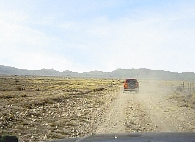
We started from the northwest, following oil roads through a refinery plant called Terrell Plant, plopped incongruously atop the desert flats. There is company housing here, but it is a dreary place, being so remote and nearby a big smelly loud refinery. We drove through the plant, the roads so far not being posted against travel.
We came to a series of large "push" gates spanning the roads. These gates are unlocked but tensioned so that the trucks can nudge into them and pass through without the need to have someone hold it open. Once through, the tension pushes the gate back to its original position. Neither of us wanted to scratch up our vehicles in this manner, so one of us would get out to hold open the gate while the other passed through.
We were now in the middle of nowhere following a warren of sandy roads. There were no features to reckon by, nor signs that named the roads. Also, the roads did not match the map. We decided to stay on the main road and hope for the best. After about a dozen miles, we came to the cliffs overlooking the Pecos River, and drove down a steep road into the bottom. Wouldn't you know, people live there. Bob had driven ahead, but I stopped to greet these people, who were undoubtedly surprised to see us.
They were friendly. I explained our intentions. They told us we were about five miles north of where we wanted to be. More importantly, they were eager for us to leave. I begged their pardons and told them I'd have to go fetch Bob, who was about a mile down the river, futzing with his GPS. I told Bob that we should vacate, and we did. We weren't going to get near the highpoint this way anyway.
We drove back up the bluffs and retraced our route through the Terrell Plant, and back out to the nearest paved road. Looking at the maps, I think we were on Upper Geddis Canyon and Richland Springs Roads. We gathered ourselves back on state route TX-349. Two hours had passed. We had a plan B.
We drove south on TX-349 to Pumpville Road. This road goes east and would bypass the highpoint to its south. The map showed lesser roads that get "close" to the highpoint, but we'd have to possibly ford the river itself and probably climb the bluffs on the other side, assuming there wasn't some road already put in.
We drove Pumpville Road, but had no luck finding decent secondary roads that would get us close to the highpoint. Everything was gated and fenced. We drove over 30 miles on this road, crossing into Val Verde County, eventually stopping for a soda and a rest in the town of Pandale, population 10, all of them in the town's cafe at this very moment. This is the type of place where people get around on ATVs. Plan B was a bust. We actually had a Plan C.
North of Pandale, we saw a "decent" road heading west. We drove in and came upon a couple push gates, We passed through these then came upon a "Posted" notice. We were about six miles from the highpoint area, and the road looked good, so we continued on. However, we came upon a second such notice. We figured we could feign ignorance if we missed one notice, but not two. Thus, we decided to exit.
We drove north on the main road into Crockett County, where the pavement resumed. Believe it or not, we had a Plan D. However, this Plan D was doomed from the start (D for doomed, get it?). A big ranch property along this road might have included the highpoint, but we couldn't get past the front, locked gates. After five hours and nearly one hundred driving miles devoted to this task, we finally conceded defeat. We drove into Ozona on Interstate-10. I got a new air-filter and went on ahead to hike the Schleicher County highpoint, while Bob drove to the town of Barnhart where we would meet a few hours later.
Date: March 12, 2002 • Elevation: 2,600 feet • Distance: 4.5 miles • Time: 1.25 hours • Gain: 200 feet • Conditions: Clear and warm
PB
From Ozona, I went north on TX-163 to eastbound Crockett County Road 09, which I followed for 15 miles as it went east then gently curved north through desolate rangeland. Eventually, this road met with Irion County Road 132, where I turned east and went three more miles to a locked gate spanning the road. I was roughly at the Irion-Crockett-Schleicher county tri-corner. Ranch fencing in the area seemed to coincide with the county boundaries shown on the map.
I walked south on a very rocky road for a mile and a quarter. The road dipped, then gained to top out, so to speak, on a very gentle ridge. It intersected a gas-line road that went southeast, and I walked this road about another half-mile to where it topped out on a rise near one of the highpoint areas. There was enough relief in the area so that finding "the top" wasn't as difficult as usual.
I returned to the first road, then hopped a fence and entered into a stand of juniper, walking in big looping arcs and trying to sense any uphill gradients in the process. I spent about 10 minutes examining this second area and left feeling pretty good I had covered it well.
Back to the road, I walked briskly back to my truck. I had walked over 4 miles in just 45 minutes. I exited the region and re-met with Bob in Barnhart, where he was relaxing at the local mini-mart.
Date: March 12, 2002 • Elevation: 2,788 feet • Prominence: 168 feet • Distance: 0.25 mile • Time: 1 hour • Gain: 20 feet • Conditions: Warming up • Teammates: Bob Martin
PB
While my truck was in the shop, Bob and I drove to Glasscock County for its highpoint, a swell of land in the northeast portion of the county. This is a ranching county, with lots of fencing and not many people. But, we got lucky: the highpoint area was easily accessed by one of the few county roads in the area. We came down FM-33 from Big Spring about 20 miles to Sherrod Road on our left (east), then followed Sherrod Road about 4 miles to where it topped out at a noticeable rise.
The highpoint contour was to the south but the road leading had a "No Trespassing" sign. Fortunately, a quarry company owns the land, and their plant was just north of the road, so we went in, got permission, and we returned to the access road. We drove in about a mile to another fence, and parked. Taking a few sight-level readings, we walked about a quarter mile in a thick cactus grove for a half-hour. The highest area seemed to be south of an abandoned house and north of a fence line, about a mile south of the Sherrod Road. We saw a few big trucks carrying enormous stone slabs for the quarry.
From here, we drove back to Big Spring so I could get my truck, then drove to Stonewall County and its highpoint for later in the day. After my time north, I headed back south for one more attempt at Southwest Mesa in Crockett County, before heading home.
Date: March 13, 2002
• Elevation: 2,580 feet
• Prominence: 540 feet
• Distance: 1 mile
• Time: 1 hour
• Gain: 500 feet
• Conditions: Clear and borderline hot
• Teammate: Bob Martin
PB
Bob and I were in Texas visiting county highpoints. We had just hiked the highpoint in Classcock County about two hours to the west. He then drove me back to Big Spring, where my truck was at a tire shop getting a flat patched after I picked up a nail last night. Once I got my truck back, we met up once again a couple hours later in the town of Aspermont. The day was dry and warm, pushing 90 degrees.
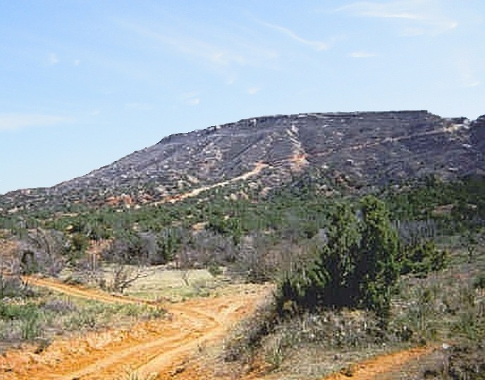
The highpoint of Stonewall County is an actual mountain. It appears to be a mesa that, over the eons, eroded into a pair of nearly-symmetric hills, hence the name "Double Mountains". For this part of Texas, anything with a few dozen feet of prominence is noteworthy. These mountains were veritable giants.
Bob and I drove in Bob's truck, taking a paved route (FM-2211) about 10 miles west and a series of good dirt roads another five or six miles south toward the base of the peaks. From below, we could see radio towers on top and a steep road cut into the side that offered a way to the top.
The road obviously gets use and is in decent shape, but it is very steep, so we hiked it. We followed the road as it snaked up the north side, made one switchback, then ended at the buildings on top. In the heat, we went slow, taking our time and watching for the loose pebbles. Nevertheless, it only took a half-hour to hike the mile to the top.
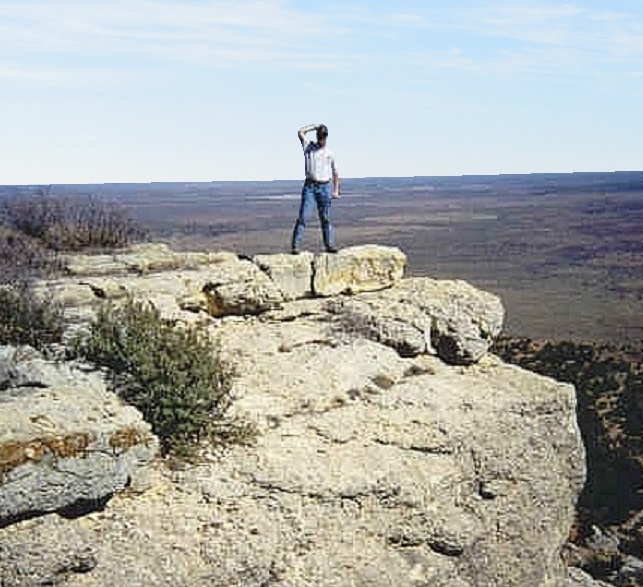
The highpoint is a benchmark at the east end of the top, with two witness markers. A rocky promontory nearby allowed for fantastic views. The land is flat as far as the eye can see, making this isolated range a true anomaly. We ate lunch, then made our way down, arriving back to Bob's truck for a total round trip of slightly over an hour. We drove back into Aspermont, where we parted ways. It had been a fruitful three days of highpoints with Bob, but now he wanted to head toward Dallas while I went north then west toward Lubbock. My thanks to Bob!
Date: March 14, 2002
• Elevation: 3,060 feet
• Prominence: 490 feet
• Distance: 0.1 mile
• Time: 1 hour for the whole journey
• Gain: negligible
• Conditions: High clouds, calm
PB
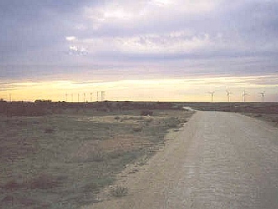
Crockett County is in west Texas, east of the Pecos River. Interstate-10 passes through it, and there is just one town in the county, Ozona, which is well known (to me) as a good place to get a new air filter, which I did a few days ago while passing through town.
Most of the county is flat and featureless, but in its northwest appendage, there are mesas that rise almost 500 feet above the desert floor. The county's highest point lies on top of Southwest Mesa. The whole mesa has been developed as a wind-farm for capturing free energy from the air, as it is almost always windy out this way.
I was here earlier in the week, scouting a way up the mesa. The road that goes to the top of the mesa starts off of US-67 about eight miles east of McCamey, but it was gated and locked shut at the highway. Immediately next door is another road that was open, leading to the "Boob Kelton" Ranch (Yes, it's "Boob"). I was aware there was a connector from the Kelton Ranch road to the windfarm road, but I could not locate it while here. I did not want waste time trying random tracks, so I exited.
(Eugene "Boob" Kelton is a somewhat well-known figure in this area. A google-search brings up many references about him and his history in the region.)
Fast forward to the 14th (today). After talking with Bob Martin (yes, it's "Bob"), he told me what to look for and gave me spot-on instructions. I was now finished with my Texas-2002 trip and heading back home, and as I would be passing by the area again, I came back for a second try.
I drove back to the Kelton Ranch road, driving in a mile and a half to a gas pipeline road. I followed this road a mile southwest to an unlocked gate that fed me onto the good dirt road to the wind farm. I drove a couple miles to a building at the base of the mesa and met a worker, so I parked and went up to him. Generally, workers don't care about visitors. He said he didn't mind me poking around on top and even "escorted" me up the road to the top. He just said to stay away from the fan towers, then we parted ways.
The highpoint is a single 3,060-foot contour on the mesa's east side. I arrived to the highpoint area with no problems. It was windy and nearing sunset, so I spent a few minutes to snap a photo and walk the area a little.
I did not linger, with a keen desire to be back on the main highway before dark. Plus, I had passed a couple gates and I was concerned I might get locked in. I made it out fine, drove back through McCamey and 40 more miles to Interstate-10 in Fort Stockton, by which time it was dark. I drove another 120 miles to Van Horn and stayed in a hotel, then drove back home the following day.
|

|