The County Highpoints of Pennsylvania
• www.surgent.net
|
 Me on the Pennsylvania highpoint rock
|
I visited 16 county highpoints in Pennsylvania over a four-day trip in May 2001, in which I also visited the state highpoints of West Virginia, New Jersey, Delaware and Maryland, plus that of Pennsylvania.
I flew into Columbus, Ohio, drove east and stayed in a hotel in St. Clairesville, which placed me near the southwest corner of Pennsylvania. I generally drove eastward through the state, then back south and west. The highpoints ranged from short hikes and drive-ups to longer hikes to nasty bushwhacks. The weather also ranged from sunny and mild, to rainy and foggy.
Main
Date: May 22, 2001
• Elevation: 1,572 feet
• Prominence: 272 feet
• Distance: 0.3 mile
• Time: 20 minutes
• Gain: 170 feet
• Conditions: Damp
PB
I drove 20 miles along Interstate-70, exiting at state route PA-221. My goal was the highest point of Washington County, the southwesternmost county in the state. The highpoint is a single hill near the community of Gale.
The DeLorme atlas shows the smaller state routes roads have numbers, but in the field, these roads are poorly signed, often with no numbers, or by some other name, or by nothing at all. Thus, I was confused and lost at times, such as now. After some wandering, I found PA-3035, drove it west to PS-3022, into a rural community of random homes, barns, churches, grassy fields and hills. This was Gale, but no sign mentions this.
Where these two roads intersect, there is a local road called Mt. Zion Road that is east of a house. I followed Mount Zion Road up a hill about a half-mile, then where the road crests, I pulled off into a clearing at an open gate. The highpoint was 200 yards east up the hill in a grassy swath cleared for a pipeline. The hike was short but steep, gaining 170 feet. A pipeline marker is found near the top, then the actual top is visible about another 100 feet away. A small clearing ringed by trees is the summit, with no views. I stayed briefly, then hiked back to my car. I was soaking wet from the damp knee-high grass. This wasn't a memorable highpoint, but it was nice to get the first one done.
I exited back to eastbound Interstate-70, coming upon heavy traffic at the Youghiogheny River, where a truck carrying watermelons had overturned. Every single one was smashed open. The cab was upright and no one looked hurt. It was easily the best-smelling vehicle crash I've ever seen ... and smelled.
Date: May 22, 2001
• Elevation: 2,980 feet
• Prominence: 260 feet
• Distance: 1 mile
• Time: 40 minutes
• Gain: 150 feet
• Conditions: Cool
PB
Next up was the highpoint of Westmoreland County, a hill tucked in the county's southeast corner, not far from the Seven Springs Ski Area. From the Pennsylvania Turnpike, I followed PA-771 southeast to Champion, then crossing into Somerset County. At a crest in the road past the county line sign, I turned left onto a dirt road, followed it a mile, then parked at a side road near a closed gate.
I walked this last road, a three-quarter mile hike with 150 feet of gain, to a decaying tower erected in a small clearing. This is the apparent highpoint, but wanting to be sure, I walked a little farther to ensure the roads did drop. Only then did I feel comfortable about being in the right place.
This was another unmemorable highpoint, but my success rate thus far was a perfect 2 for 2.
Date: May 22, 2001
• Elevation: 2,994 feet
• Prominence: 854 feet
• Distance: 1.5 miles
• Time: 1 hour
• Gain: 400 feet
• Conditions: Rain
PB
Fayette County's highpoint is just minutes from Westmoreland County's highpoint. I drove Seven Springs Road to the Seven Springs Ski Resort. When the snow melts, the resort is open to hikers, bikers and tourists. Today, the lot was full for some reason. They host conventions, too. I didn't see too many people outside.
I hiked a service road uphill between the #5 and #6 ski lifts, then at the top of the #5 lift, I barrelled directly up the grassy slope to top out on a ridge. I then walked another quarter mile to the Tahoe Lodge.
Behind Tahoe Lodge is a water reservoir, and behind this, relative to the Lodge, is the highpoint. I hiked counter-clockwise around the reservoir along a service road, then hiked up a small knoll near the top of more ski-lifts. In the woods behind this run was a set of boulders which appeared to be the highest point. I tagged the tops of these rocks. I then continued around the reservoir but the road actually dropped about 40 feet and no other areas appeared to get as high as the aforementioned rocks. I also hiked out another road in the area to scout and be sure.
There was drizzle that developed into a downpour as I hiked back to the car. I was soaked when I arrived back at the car. Of my three successes today, I enjoyed this one the best.
Date: May 22, 2001
• Elevation: 3,120 feet
• Prominence: 780 feet
• Distance: 0.1 mile
• Time: 10 minutes
• Gain: 10 feet
• Conditions: Unsettled
PB
The day was still young, but I was soaked from my previous hike. Next on the agenda was Blue Knob, highest point in Bedford County, and second-highest peak in Pennsylvania. I could drive this to nearly the top. Since I was still soaked, a drive-up was welcome.
From the town of Pavia on route PS-869, I drove four miles north to PA-4035, signed as Forest Road and the entrance to Blue Knob State Park. The drive to the top was fast and eventless. I parked and clambered up a couple hills near the tops of the ski-lifts. Some guys were doing general maintenance work, but they paid me no mind. I kept my visit short, happy to have another success, albeit a very easy one.
Alas, I would have my first failure not far up the road. I wanted to hike Schaeffer Head, the highpoint of Blair County. However, the rain was falling heavily, and I was looking at a bush-whack the whole way up. I didn't want to get any more wet, so I passed by, and continued my journey. The fog in places was extremely thick, with perhaps 100 feet of visibility. I carefully made my way to Altoona.
Date: May 22, 2001
• Elevation: 2,630 feet
• Prominence: 390 feet
• Distance: 0.5 mile
• Time: 20 minutes
• Gain: 30 feet
• Conditions: Misty drizzle
PB
Centre County is aptly-named, being in the center of the state. Its highest point is easy to visit, a broad hilltop with a radio tower, accessed by a good gravel road. The ridge has a benchmark named "Snyder" on its southeast end. The higher point on the northwest end is barely inside Centre County.
From Altoona, I drove north on Interstate-99 to Tyrone, then PA-453 for seven miles to a bend in the road. I exited the road and drove a lesser track another mile to a gated road on my left. I parked here.
The weather was dismal, with dense fog and steady rain. Fortunately, the hike was short, a quarter mile walk with about 30 feet of gain to the top. I couldn't see anything, so after a moment or two, I returned to my car and drove back to Tyrone and killed time at a fast-food restaurant.
Date: May 22, 2001
• Elevation: 2,400 feet
• Prominence: 40 feet
• Distance: 0.1 mile
• Time: 10 minutes
• Gain: 5 feet
• Conditions: Gloomy
PB
It was getting late, and I had one more highpoint I wanted to visit before I ceased operations for the day. My goal was Big Flat on Greenlee Mountain, the highest point in Huntingdon County. I located myself to the city of State College, home to Penn State. I had been here before in 1987, staying a few days with some Penn State pals I had made in Australia earlier that year. Here I was again.
On US-322 east of the city, I followed Bear Meadows Road south to the Tussey Mountain Ski Area. I then followed North Meadows Road about 3 miles to Gettis Ridge Road on the right. Then I drove up Gettis Ridge Road to its crest. This is the highpoint. I didn't spend long here except to walk the area and into the woods to surmount small rock piles to "ensure" a successful visit. It's a heavily wooded area but pretty, almost like a park. That was it for today and I was bushed. I spent the night in Danville.
Date: May 23, 2001
• Elevation: 2,449 feet (summit), 2,320 feet (CoHP)
• Prominence: 209 feet (summit)
• Distance: 2 miles
• Time: 40 minutes
• Gain: 200 feet
• Conditions: More mild
PB
I had a restful night in Danville, and the day started a little more calm than from yesterday's steady rain. After packing up, I drove PA-487 from the town of Red Rock to a logging road that lead to the highest point of Columbia County.
I parked in a clearing and hiked up a road, bypassing big piles of logs. I saw no one and in moments I had topped out on the hilltop near a lookout tower --- Red Rock Mountain's summit. This is not the highpoint, as the hilltop is in Luzerne County. The Columbia County highpoint is on the west slope, at the Sullivan, Columbia and Luzerne county tricorner.
I followed a path west into the trees marked with notices against trespassing. This was promising as it likely indicated the county boundary. I then paced the whole area, meandering into and out of the trees. I found a white-painted cement block about a foot high, solidly planted in the ground. I presumed this to be the point at which the three counties meet. If so, then I had confirmation I was in the right place.
I spent 40 minutes here before returning to my car, a total journey of two miles.
Date: May 23, 2001
• Elevation: 2,460 feet
• Prominence: 220 feet
• Distance: 2 miles
• Time: 1 hour
• Gain: 260 feet
• Conditions: Cloudy but not raining
PB
From the Columbia County highpoint, I drove north on PA-487 for four miles to a Pennsylvania Game Lands access road to the right, then east and south clockwise for two miles to Opperman Pass. This location is not marked on the road, so I had to watch my odometer carefully and try to sense when the road "crested" and started to drop. The area has many downed trees and lots of crud. I wasn't sure if I was in the right place, so I parked and just started to explore ways into the forest, and got kind of lucky when I found a hunter's trail.
The trail is primitive, but it is marked with orange and white blazes on the trees and rocks. About a half-mile and 100 feet of gain later, I came to a grassy swath in the forest which was an old railroad bed. The track was long ago removed, but the ground had that "corduroy" effect from the ties that use to lie here. I turned right and followed this for about 0.4 mile until it started to drop slightly. According to the map, this put me just below the summit of Cherry Ridge, Luzerne County's highest point.
Unfortunately, there is no trail to the top. I left the old railroad grade and started up the hill. The woods are thick, and there were an enormous number of downed trees. Footing was tricky on the slick, wet slopes. After about a half-hour I came out to the "top", as best as I could determine. The downfall was awful and made getting around really tough.
I hiked and clambered carefully to where the highest area seemed to be, then walked a few hundred feet along the ridge in opposite directions to be sure there weren't other higher points. I'm pretty sure I viisited the highpoint, as I found surveyor's ribbon tied to some branches in the area. I was convinced enough to begin the hike out.
The hike out was fairly easy, once I was back to the railroad grade and the trail. The rest of the day was spent doing much easier, less bushy highpoints. This one sucked.
Date: May 23, 2001
• Elevation: 2,094 feet
• Prominence: 774 feet
• Distance: 0.1 mile
• Time: 10 minutes
• Gain: 10 feet
• Conditions: Clearing and mild
PB
After my battle with the logs in Luzerne County, I drove to Northumberland County for an attempt of its highpoint, near the city of Shamokin. However, the access road was muddy with big pools of water from yesterday's rain, so I didn't chance it and moved on.
I was deep in the hills and following meandering state routes through little towns such as Kulpmont, Mt. Carmel and Ashland. They're all lovely places, with old-style homes, narrow streets, rustic shops, and so on. However, I was driving slowly and after awhile, I was tired of the old-timey charm. Thus, when I finally got onto Interstate-81, I slightly exceeded the posted speed limit until I drove to the town of Delano. The highest point of Schuylkill County, Bears Head, is nearby.
Northeast of town, I drove PA-1016 to a well-maintained gravel road to the top, parking in a pull-out about 100 feet short of the towers at the top. I explored the main tower area plus a side road to be sure. My visit was short, but I was happy to get an easy one.
At some point I stopped in a gas station or mini-mart, I forget what exactly, and asked how "Schuylkill" is pronounced. The guy told me "skoo-kull". Now I knew.
Date: May 23, 2001
• Elevation: 2,180 feet
• Prominence: 404 feet
• Distance: 2 miles
• Time: 40 minutes
• Gain: 400 feet
• Conditions: Nice outside
PB
Next on my list was Big Boulder Ski Area on Lake Mountain. I followed Interstate-80 to state route PA-115 near the Pocono Raceway, then onto PA-903 past the Carbon County line sign, past the ski area entrance and south to a dirt road that leads to the top. I parked in a clearing off the main road.
I followed the road down a dip to a reservoir, then hard-left onto another road that goes to the top. These roads are for the ski area to access its machines, but apparently hikers are not prohibited. However, I saw no one.
After 20 minutes and a mile, I arrived to the top and its towers The highest point is a jumble of rocks about a three-minute walk west of the first towers. I climbed ten feet to tag the top rocks. Someone had thoughtfully installed metal steps ages ago, but I did not need them.
I jog-walked back to my car, gone a total of 40 minutes. I was now on the east boundary of Pennsylvania, and soon, I would leave the state and visit the state highpoint of New Jersey. After that visit, I drove south in the waning daylight toward Philadelphia. Frankly, I was tired and wanted to get a hotel somewhere. However, there was one more easy county highpoint close by, and I wanted to visit it before powering down.
Date: May 23, 2001
• Elevation: 500 feet
• Prominence: 40 feet
• Distance: a few feet
• Time: 1 hour overall
• Gain: 2 feet
• Conditions: Dark
PB
Delaware County is a suburb county of Philadelphia, and its highest point is along Valley Forge Road on the county's west boundary. It was about 8:30 p.m. and dark. I hoped I could drive out, find it, tag it and be on my way. However, I had no detailed street map. I had no luck finding Valley Forge Road at first. I had no idea if it was a major boulevard or a small residential street.
I stopped into a CVS drug store and bought a city map. This helped a lot. I followed US-30 to the Chester county line sign, then south on Sugartown Road for a mile to Valley Forge Road. Slowly driving along Valley Forge Road, I stopped whenever it crested and made short walks of the immediate area. There are nice, upscale homes here, and I did not want to draw attention to myself, given that it was pushing 9:30 p.m. I did not bother to hike onto lawns or hedges or other built-up areas.
It was way late by now, but had no luck finding a hotel. I drove farther than I wanted to before finally finding a place to stay off Interstate-95 south of Philadelphia. Tomorrow, I started with a visit to Ebright Azimuth in Delaware, the state.
Date: May 24, 2001
• Elevation: 2,270 feet
• Prominence: 630 feet
• Distance: 4 miles
• Time: 1 hour
• Gain: 140 feet
• Conditions: Lovely
PB
From Delaware, I re-entered Pennsylvania and proceeded west along US-30 towards Lancaster and Gettysburg. I saw a few Amish and a few horse-and-buggies on the road. In Gettysburg, I thought about visiting the Civil War site, but it was packed with tourists, so I moved on.
The immediate objective was Blue Mountain, on which sat the highpoints of Cumberland and Perry counties. From Shippensburg, I followed PA-696 and PA-997 north toward the mountain. The Amish farms were cool. You know them because they lack any vehicles or other tell-tale signs of modernity. They are clean, well-kept places. This was my first time in Amish country, and I enjoyed it very much.
About where PA-696 and PA-997 meet near the Pennsylvania Turnpike, I took Three Squares Hollow Road into the mountains, the pavement giving way to gravel, which I followed for about 9 miles. I parked near a side road, closed to passenger vehicles.
The hike was two miles each way along this road. The rains had left long segments of it muddy and pools of water, so I had to bypass the road in spots by going into the forest. I scared a lot of toads, plus a few deer. By now, the sun was out and it was humid. The walk gained just 140 feet, so it was level and I made good time.
The road crests to near a 2,270-foot spot elevation as shown on the map. This is the Cumberland county highpoint. The Perry county highpoint was more uncertain, given the uncertainly of the county boundary along the ridge. I hiked north into Perry County from this point just to show good faith. I immediately returned to my car, my total time gone one hour.
The drive down was full of surprises. Coming down the mountain road, I came upon a big Amish family out for a picnic, about 20 of them, with six buggies parked along the road. I waved hi, but they just stared at me. Then a bee flew into my car and started to harass me. I swatted it into the space below the windshield and the dash, thinking it was dead. But five minutes later it came out buzzing again. I was able to smash it while not crashing the car at the same time.
Date: May 24, 2001
• Elevation: 2,458 feet
• Prominence: 1,438 feet
• Distance: 0.3 mile
• Time: 30 minutes
• Gain: 120 feet
• Conditions: Mild
PB
Big Mountain is the highpoint for both Franklin and Fulton Counties, assuming the county line passes over the summit. Not all maps are in agreement on this, so to be sure, I also visited nearby Kimber Mountain which was the only other possible (not probable) contender for the Franklin County highpoint.
I left US-30 at the county line sign and followed Augwick Road north about a mile to Tower Road, which led to the top. The roads were paved or gravel and easy to drive. The road rings the top, with parking spaces and places to make short hikes. I walked the top and tagged high rocks and anything else of interest. A 2,458-foot spot elevation was noted on older maps. On the newer maps, a 2,453-foot spot elevation is noted at the south end of the loop road. The county line appears to swing just east of the summit, which would place the entire top in Fulton county. Just to be sure, I walked the perimeter of this road to "get" Franklin's highpoint as well. It shouldn't be this complicated. Grrr.
Date: May 24, 2001
• Elevation: 2,443 feet
• Prominence: 1,103 feet
• Distance: 1 mile
• Time: 1 hour
• Gain: 190 feet
• Conditions: Mild
PB
I then drove to Kimber Mountain via the tiny town of Enid. From US-30, I took PA-915 north to PA-4013 to Enid, then turned left onto Enid Road, which merged with Schenk Road, which eventually leads to the top of the range. From here, I hiked south on a jeep road, keeping right at a junction, for about half a mile. Where this road crested I bushwhacked to a rounded, wooded summit.
Kimber Mountain stretches across a long distance and the actual hill's name is Rays Hill. It has a spot elevation of 2,443 feet which gives it a remote chance of being the highpoint of Fulton County. It was a nice, short hike.
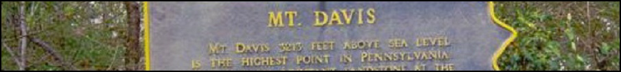
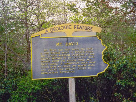
The weather was holding up well. It was about 2 in the afternoon and next on my agenda was the state highpoint, Mount Davis.
Date: May 24, 2001
• Elevation: 3,231 feet
• Prominence: 653 feet
• Distance: 0.1 mile
• Time: 10 minutes
• Gain: 5 feet
• Conditions: Clouding up
PB
I arrived to the Mount Davis area by way of Cumberland, Maryland, via Interstate-68 and US-216 to Salisbury, then PA-669 and local roads to the Mount Davis Recreation Area. It was nearing 5 in the afternoon, but surprisngly, I was the only person here when I rolled in.
Mount Davis has a broad, gently sloping profile that is imperceptible to the eye. There is no climbing required, just a short walk to the lookout tower and some big boulders that contain the benchmark and the state's highest natural point. I took my photos, then scaled the lookout tower for great views over the trees. After a few minutes, I retreated and was on my way. I drove west on Interstate-68 into West Virginia and one more highpoint for the day in Monongalia County. The sky was getting threatening.
|

|
(c) 2001, 2020 Scott Surgent. For entertainment purposes only. This report is not meant to replace maps, compass, gps and other common sense hiking/navigation items. Neither I nor the webhost can be held responsible for unfortunate situations that may arise based on these trip reports. Conditions (physical and legal) change over time! Some of these hikes are major mountaineering or backpacking endeavors that require skill, proper gear, proper fitness and general experience. |