The Mountains of Nevada
• www.surgent.net
|
| Ruby Dome |
• Highpoint: Ruby Mountains • Highpoint: Elko County • Humboldt National Forest |
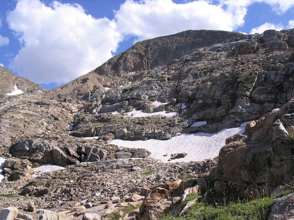
 Griswold Lake
|
Date: August 13, 2006
• Elevation: 11,387 feet
• Prominence: 4,793 feet
• Distance: 14 miles
• Time: 13 hours
• Gain: 5,400 feet
• Conditions: Beautiful
• Teammates: Ben Knorr, Kevin & Sunshine
Nevada
•
PB
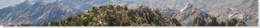
Ruby Dome tops the Ruby Mountains of northeast Nevada, overlooking the city of Elko. The summit is a pyramid of rock, with a noticeable point to the top, visible from below. The Rubys are one of the more well-known mountain ranges in Nevada, with its multitude of summits and its many beautiful canyons. Unlike many of the Great Basin ranges, the Rubys are rockier and wetter, giving it a more Colorado-like feel. Many people come here to hike, camp and hunt, with Lamoille Canyon as its most fanous draw. Ruby Dome sees its share of hikers, but only the super-serious. There is no trail to the top, and the climb requires a full day, about a vertical mile of gain, and some skill at route-finding and rock-hopping on exposed talus.
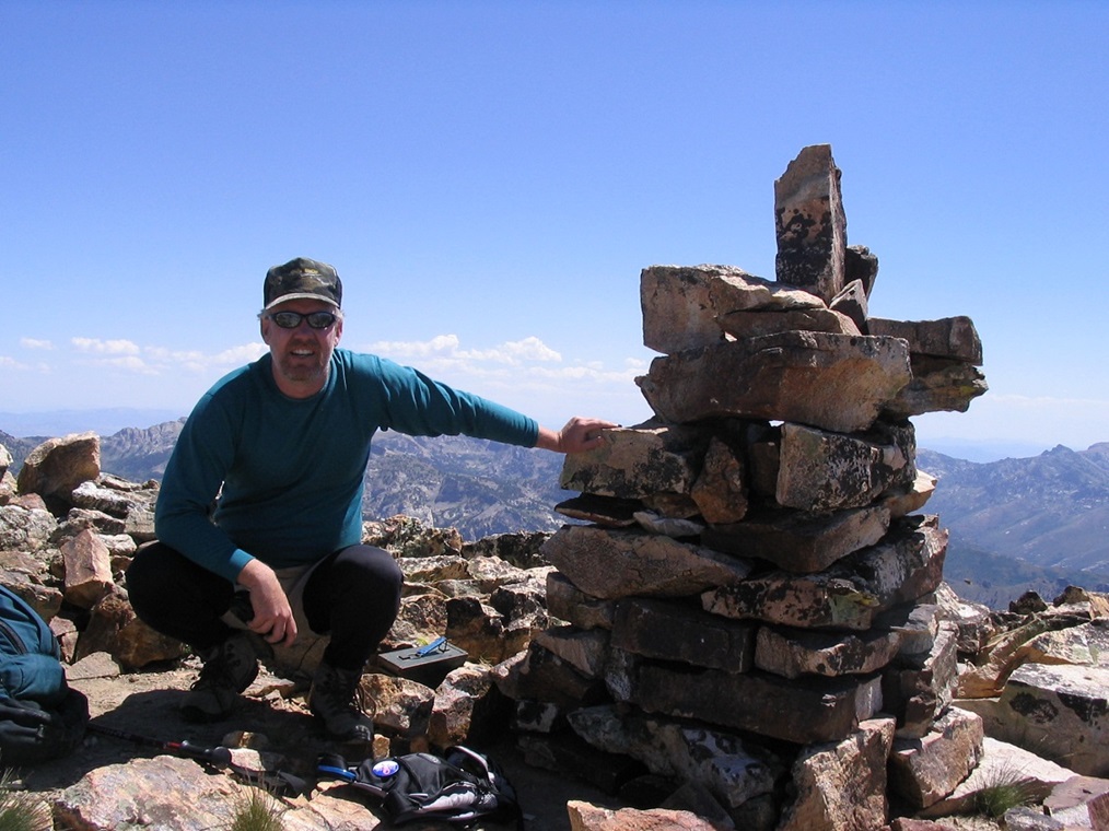
For me, a successful summit of Ruby Dome would be the culmination of my Nevada County Highpoints project. I climbed my first, Boundary Peak, back in 1995. Between 1999 and 2005, I had visited thirteen more county highpoints, leaving me just this one to hike, which seemed like a good peak on which to finish my project. I was joined by Ben Knorr, a Salt Lake City-based climber who I knew through the County Highpointers club. We set Sunday, August 13th as our primary attempt date.
I flew into Salt Lake City, where I talked the car rental guy into an upgrade to a Jeep Equinox for about half its usual price (thus, I could sleep in it and save money by avoiding hotels a couple of nights). I spent time in the Salt Lake area getting supplies before setting out on the long journey on Interstate-80 across the Great Salt Lake Desert into Nevada and on into Elko. It was about 230 miles one way, and I killed some time in Elko at a neat little book store called the Blu Coyote talking to its owner about hockey. In the late afternoon I drove out on highway NV-227 south of Elko through the sprawling "development" of Spring Valley. I followed Pleasant Valley Road to the gate and trailhead, but decided this wasn't a good spot to camp, so I drove back to the highway and into Lamoille Canyon, where I found a spot on forest land near Lamoille Camp. I "camped" in the vehicle. In fact, I fell asleep around 6 p.m. I must have been really tired.
I was awake by 3:30 a.m., fully rested and ready for the day's big adventure. I decided to drive back to the gate on Pleasant Valley Road and wait for Ben. People who live in Spring Valley have access to this gate as part of their homeowner's association deal, while the rest of the world can rent a key for a deposit, as long as it's during a weekday during normal business hours. No such luck for me: arriving Saturday for a Sunday climb, I had no key. All the key does is shave off an extra 1.2 miles of hiking each way, and about 500 feet of gain. Ben rolled up around 5 a.m. local time, just as the sun was barely rising in the east, and by 5:30 we were ready for our long hike. The gate is at 6,040 feet elevation. We would be climbing this mountain from its base to the top, 5,400 feet of gain to the summit.
The walk from the gate to the upper parking area and usual trailhead took about 20 minutes and went quickly. We walked past a mileage sign, across a new wooden bridge that spanned a flowing creek, and took a right at a T junction. For the next three miles (and 2,800 feet of gain), we followed this good trail up Hennen Canyon, paralleling Butterfield Creek. The lower trail crosses open brush and sage slopes, and gains steeply as it sidehills up a rounded ridge. We passed a gate (presumably the National Forest boundary) and continued upward. It entered into forest, mostly aspens, with lots of grasses and shrubs fed by the creek, then alternated through tree cover, open meadow, and occasional rocky sections. The trail itself was easy to follow and we made good time.
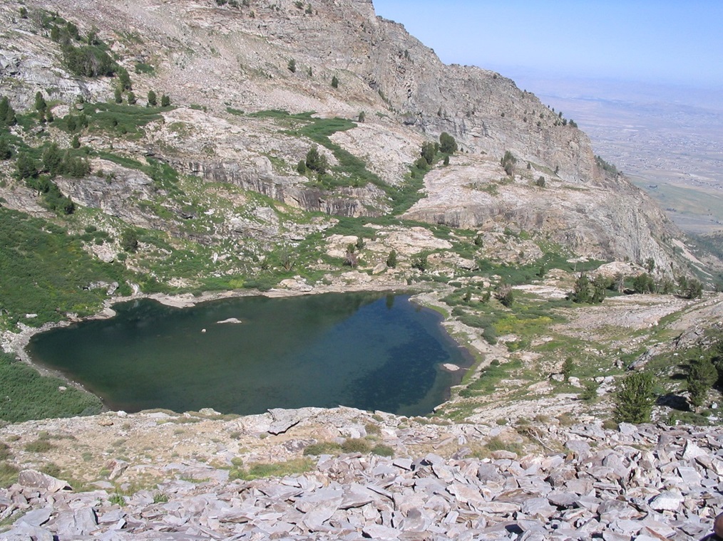
At above 8,000 feet, we encountered the first significant rock band. The trail was cairned in places, but occasionally we had to use comon sense to keep on route. By 8,800 feet we were essentially walking entirely on rock, working our way toward trees and a noticeable shelf up on the headwall. In time we had come upon Griswold Lake, where we met up with a number of hikers breaking camp. They had hiked Ruby Dome the day before and gave us some suggestions. We had a chat, then hiked a few more feet to a rocky flat area on the east side of Griswold Lake where we sat and had an extended break. It was just after 9 a.m. and we had been hiking for 3.5 hours, gaining 3,300 feet. Before I got too proud of this feat, I reminded myself there was still another 2,100 feet to go, and probably not over nice trail either. We spotted another couple come up to the lake and take refuge in a shaded area in the trees for a break.
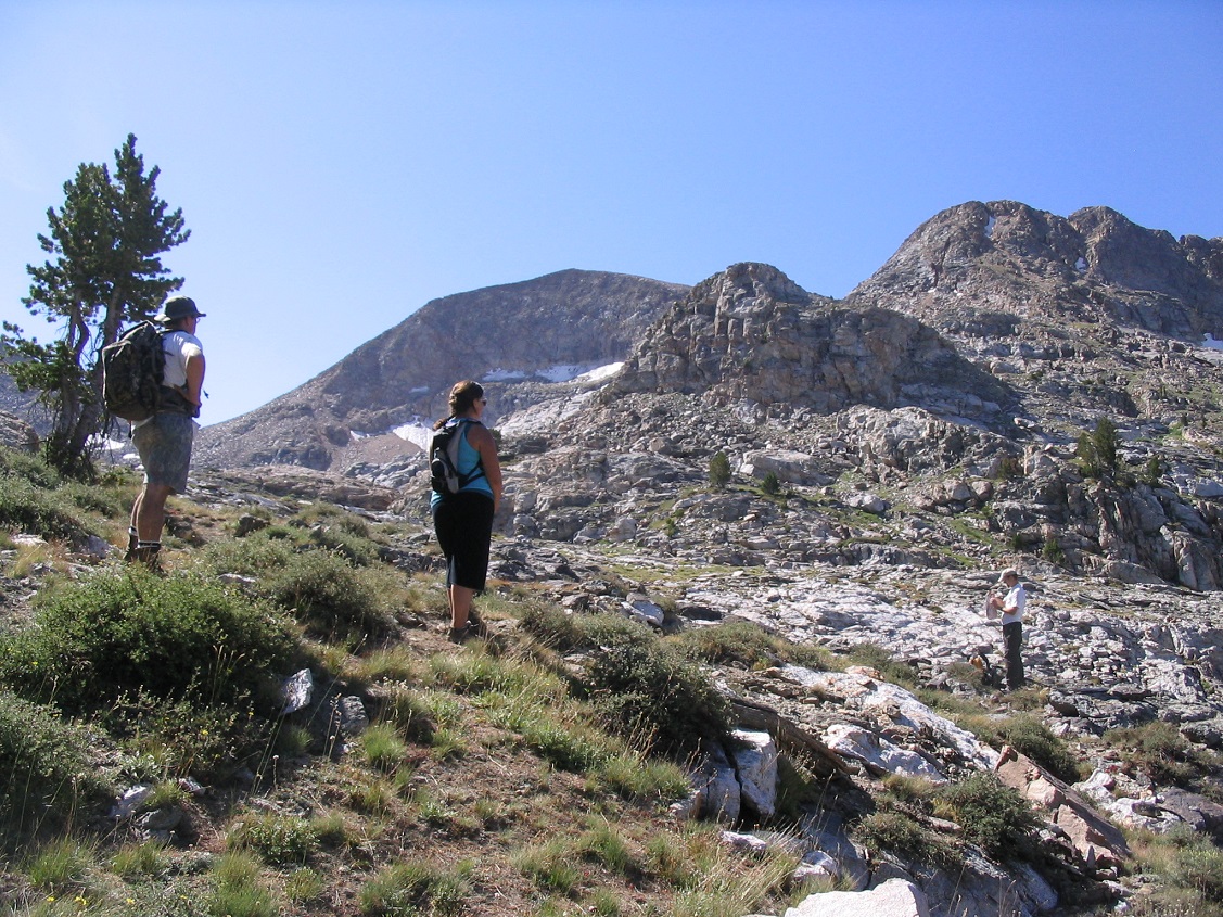
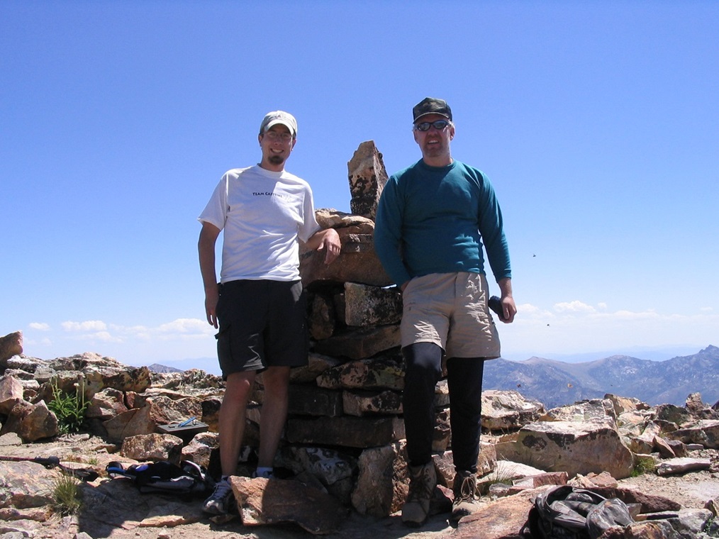
After 45 minutes, Ben and I got moving again. We started barreling up the steep talus shelves east of Griswold Lake, but this proved to be dicey as many of these large blocks gave an uncomfortably hollow sound when being stepped on. We located ourselves onto a wide flat area, and that's when we saw the other couple, now ahead of us, sort of. They had followed a different route and when they saw us we were about 200 feet apart, striking up a conversation. We discovered we all had the same goal in mind so we decided to team up into a group of four. Our new teammates were two Elko locals: Kevin and his sister-in-law, Sunshine. Neither had climbed their home mountain before and were eager for the summit. Together we followed a use path up a steep slope and surmounted a saddle at about 10,140 feet, north of a notable landmark, a tooth-like 10,428-foot peak sitting above this saddle. At this saddle, we had an unobstructed view of Ruby Dome, now much closer, much more grand and considerably more beautiful than from way down below. We still had our work cut out for us, though.
We hiked toward the base of the 10,428 peak, and walked up an easy cleft between it and a rock bald. Shortly the route began a gentle decline into the broad upper reaches of Seitz Canyon. Ruby Dome's massive north face, nearly vertical, gave way to fields of giant talus and lingering snowbanks. Below these gave way to gentler tongues of talus blocks and intervening patches of grassy ground, complete with wildflowers. A stream flowed from the rocks, heavy enough so that we could hear it from about 200 feet away. We walked to this stream and took a break, refilling water bottles. The reports we had suggested to find ramps that would lead us up directly from this basin and onto a series of ledges, eventually leading up to the prominent west ridge of Ruby Dome's summit. However, we didn't see anything obvious and it seemed to us that proceeding generally straight, cutting across the bottom of Ruby Dome, was our best bet. We walked past this flowing stream, up more talus ramps, and soon came upon a large, level snowfield. We were essentially dead center below Ruby's summit, high above us by a good thousand vertical feet.
We had reached a decision to attempt Ruby's summit from its steeper east ridge, so with that in mind we worked our way toward the east ridge and saddle. Coming off of Ruby Dome's summit was an intervening rib of talus, set generally northeast of the summit, and leading all the way up to a point on the east ridge, a point where the slope moderated from steep to easy, at least what our eyes could tell us. Here, we seemed to generally split into three groups: Ben bounded up and went high up this talus rib, while Kevin and Sunshine stayed lower and took a more moderated approach to the saddle. I figured both ways were good, so I cut the difference and followed a route between the two.
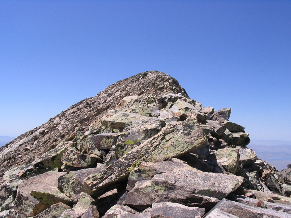
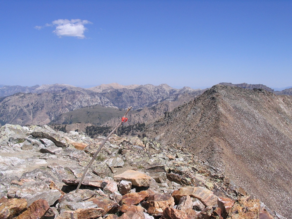
The talus on this ridge was steep and sometimes not set solidly. We took each step carefully and tested each rock to be sure it wouldn't tip or slide under our weight. We convened again at a point about 200 feet below the ridge point, and about 100 feet above the saddle. Our elevation was 11,100 feet. After another rest, we weren't sure what to do next other than to go up and hope for the best. We hiked a few more feet to attain the ridge itself, now able to look down the cliffs on its south side. Above us was the aforementioned ridge point, a narrow clump of randomly-placed rocks, pointing into the sky like a finger. The summit was invisible from here. I have to admit (and I think the others would agree) that even getting to this point looked pretty scary, and not a guarantee that there would be safe passage afterwards. So close to the summit, we were concerned that we had run up a dead end. There was only one way to find out.
We strung out in our usual pattern: Ben first, me second and Kevin and Sunshine not far behind. The final 60 vertical feet to this point was manageable, but class-3 scrambling all the way up with some portions of exposure. The rocks were solid and full of handholds, and the climbing went well. Soon, Ben was near the top of this point. The the rest of us stopped for a report. Shortly, he came back with good news: he could see the summit close by and that the ridge was narrow, but safe. I surmounted this ridge point a few moments later, followed by Kevin and Sunshine.
There was the top, tantalizingly close, maybe a hundred vertical feet higher across a narrow catwalk with thousand-foot-plus drops on both sides. We took each step with the greatest of care, believe you me. Only one obstacle remained: about halfway the ridge narrowed too narrowly and we felt it wise to drop a bit onto a steep but safe rock slope below and traverse this section, 30 horizontal feet where we dropped about 15 feet to get past this portion. At this point Kevin and Sunshine got into the lead and it was Sunshine who had the honor of being the first to tag the 4-foot tall cairn on the summit. It seemed right to allow the local Elkoans be the first to the top.
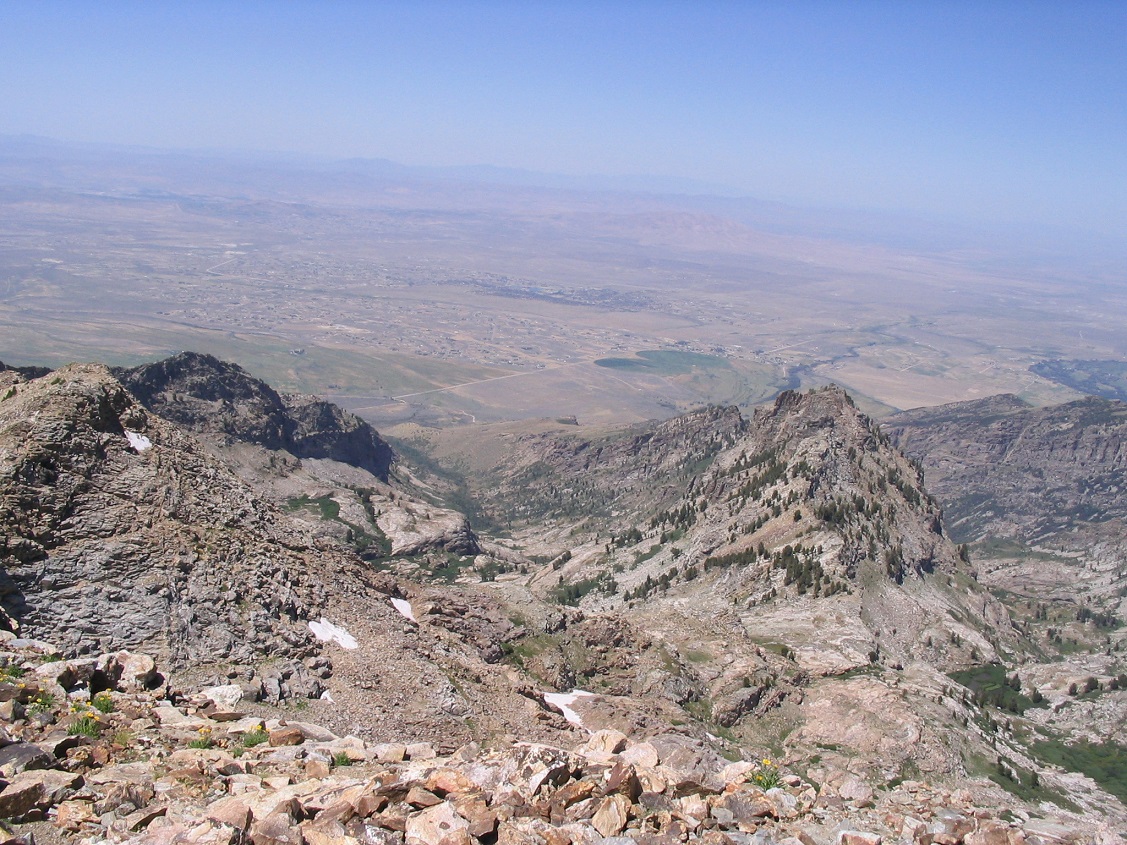
Within moments, the four of us were at the top. For all of us, a wonderful end to a grueling climb and for me, a completion of all seventeen Nevada county highpoints. I was thrilled, but also very tired and kind of itching to get right back onto the talus to get down onto safer ground. We spent about 20 minutes on top, signing in and taking photos, picking out nearby summits in the Ruby Mountains and far-away peaks way off to the north. Elko laid out on the tan-colored desert floor, a jumble of lines and patches of green, a vertical mile below us. Now to get down.
I took the lead and we strung out again, each managing the steep downclimb with care, slowly working our way down onto the fields of talus, opting to go lower than before then cut across. This worked well, although we had to zig-zag around the snowbanks and avoid cliffs that were invisible until we actually were feet from their edges. In less than an hour we were back to the level snowfield below Ruby Dome, where we took an extended break and where we could sit and relax, knowing that the really nasty stuff was now behind us. We spent 40 minutes here, laying down and enjoying the mid-day sun and the gorgeous profile of Ruby Dome's unique summit ridge.
The hike to the 10,140-foot saddle was easy, and the downclimb to Griswold Lake went well, scooting and slithering down rock faces and clefts, all the while following a scant trail beaten in by previous hikers. In another hour we were at Griswold Lake, taking another break. I was dehydrated, and it seemed no matter how much I drank, I was thirsty again. It was uncomfortable, but I still had 2 liters of water on me, and with a flowing creek paralleling our route all the way down, water would always be at hand, so I didn't worry too much. The thought of a cold Gatorade and later on, a beer, kept me motivated.
From Griswold Lake, the hike back to the trailhead took two hours, with Ben and I hiking as a group and Kevin and Sunshine about five minutes behind us. The sun was behind the ridges, giving us welcome shade. Ben and I staggered back to the trailhead, where we both sat on the new footbridge over the creek. I laid down and snoozed, but soon Kevin and Sunshine were out, and they kindly gave us a ride down to our cars (they had a key and had parked at the higher trailhead). Back at the gate and our cars, we said our goodbyes, then Ben and I parted ways, a good end to a very successful afternoon. For us, it had been a thirteen-hour summit day, including all of our breaks. Roughly, it was about 7.5 hours to the top and 4.5 down. I don't care if it took me twenty hours, I felt thrilled to have summitted Ruby Dome, and to have been accompanied by three great teammates! Thanks to Ben, Kevin and Sunshine.
I drove into Elko, stopping at the first Stop-n-rob I could find, and sucked down a green Gatorade. Wow that was good. I got a hotel room at the main casino in Elko and treated myself to a prime rib sandwich and 12 hours of sleep. The next day I drove back into Utah with plans for more peaks, but rain and nasty roads shooed me off a couple peaks. I was able to visit the rocky highpoint of Wasatch County a couple days later as consolation before flying home to start another year of teaching.
|

|