
The Mountains of New Mexico
www.surgent.net |
|
Magdalena Peak • Aden Hills Highpoint I had driven out to Las Cruces yesterday to spend a couple days in and around the city tagging peaks. I had four peaks on the agenda, two west of the city, and two more closer in. I was up before dawn, intending to be on the road before the sun rose.
Date: December 26, 2023
• Elevation: 6,625 feet
• Prominence: 1,925 feet
• Distance: 5.4 miles
• Time: 1 hour, 40 minutes
• Gain: 1,065 feet
• Conditions: Freezing cold and breezy, sunny skies
New Mexico
•
Main
•
PB
•
LoJ
•
USGS BM Datasheet
I left my hotel at 6:30 a.m., temperatures in the high 20s and a thick layer of frost on my windshield which delayed me while I awaited it to defrost. I did not have to drive far, about 12 miles westbound on Interstate-10, exiting at the Corralitos Road exit (#127).
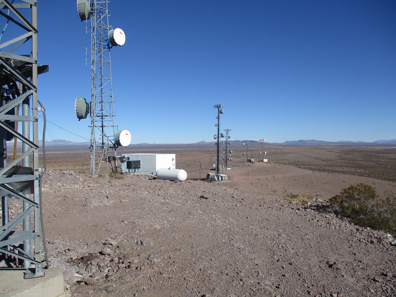
First on the agenda was Magdalena Peak, highest point of the Sierra de las Uvas (Range of the Grapes), which rise northwest of Las Cruces. The top is home to an FAA radome, so a paved road goes all the way to the summit. However, it is gated a couple miles below, meaning I would have to walk it. I was fine with that.
Once off the interstate, I got onto the northern frontage road and went east again about a mile, then making a left (north) onto Corralitos Road, also designated Doña Ana County Road C09. It was still mostly dark, but sunlight was now visible to the east, actual sunrise still about twenty minutes away.
I drove north on this decent road, which is paved. After a couple miles it bends left to the Corralitos Ranch. The road then goes right (north again) to bypass the ranch. Here, the road's quality drops a notch. It is still paved but not striped, with plenty of potholes to watch out for. I generally motored along at 40 miles per hour.
There had been a full moon last night, so it was setting over the western peaks as the sun was steadily rising to the east. The peaks were tinted red by the low sunlight, and the moon looked bigger than normal as it "touched", then set behind the peaks. I was alone in open desert, temperature outside in the low 20s now, clear with no clouds. I wish I could have taken an image of the setting moon but I know it would not have come out well. It was a surreal scene.
The road stays north for a couple more miles, then swings west, now designated CR-D12. It approaches a low pass with a couple antenna structures on the flanking hills. On the other side, it now enters the Organ Mountains-Desert Peaks National Monument. The road's condition stayed steady.
For the next few miles, the road crosses a broad valley. I had excellent views now of the peak and the radome atop it. The road crosses through at least a dozen arroyos along this segment. The arroyos are concrete with sudden dips so I had to slow each time. Many had mud and other crud in them from recent rains.
I got to one such arroyo and had to stop. It was filled with water and iced over, at least 30 feet long and 20 feet wide. I got out to "test" the ice. It was thick but if I placed my weight on it, it would crack. The car would surely crack through the ice. However, I had no idea what kind of mud awaited me under that ice, and I would not be able to use momentum to power through the cracking ice as I might normally would with normal water.
On one side was a muddy berm, and on the other side was drier desert but with a number of little ditches. The mud was still hard due to it still being freezing, so I eased onto the muddy berm and got around this icy barrier, only pushing through a few feet of the icy-water-mud at the end. I skidded and yawed but it worked. One upside: the whole right side of my car got caked in mud.
Beyond this barrier, things went well. The road steepens up one grade and through a pass, then wanders through a higher valley and up one more grade where the pavement was decaying. Past that, I had another mile or so to where the road is gated below the mountaintop. I had driven just under 23 miles since leaving the frontage road, taking about an hour to do it. It was a little after 8 a.m.. I had not seen another car or vheicle the entire time.
The road is gated because after the gate, it is extremely steep and an attractive nuisance to the unwary or unskilled drivers. It's also nominally off limits due to the FAA radome atop it. However, this is National Monument (Federal) land, not private land, and normally, the radomes are themselves behind subtantial fencing at the summit itself. I felt comfortable in bypassing the gate and walking the road to the top. I was not expecting anyone to be here anyway, especially very early on the day after Christmas.
When I got out of my car, the wind and cold knocked me back. It was in the mid 20s, said my car's temperature gauge, and with a steady breeze. I bundled up with polypro, multiple fleece layers, caps and buffs, the only exposed parts of my body being my nose, eyes and hands. I did not bring a pack. I just put a bottle of water in a pocket with my keys, phone and wallet, and started walking. I did not even bring my trekking poles.
I walked fast. I had to, to stay warm. I also wanted to be up and down this peak as soon as possible. The climb was just a road walk, which was easy. It was steep, one segment a sustained 20% grade which would tax most vehicles.
The road makes a couple turns then one long ascending traverse to gain the plateau top. It then slowly bends back south, the radome and summit now in view about a mile away. The sun was up by now, warming things slightly, but it was still very cold, and breezier once on top the plateau. I walked quickly and was at the summit in about 45 minutes, covering 2.4 miles and 930 feet of gain.
As expected, the radome and the other buildings are inside substantial fencing with razor wire atop it. I walked the perimeter (counterclockwise, of course). On the western edge, there are two reference markers for "Flat Top" benchmark. I took this to be the highest point(s). The actual benchmark was probably bulldozed away when they flattened the top for the towers. Nothing inside the fencing looked higher than where I stood. I snapped a couple photos, but kept moving, never really stopping.
I retraced my route out, using gravity to assist, and moving as quickly as I could, was back to my car in under 45 minutes. Counting the time spent on the top, my round trip took 1 hour and 40 minutes. I was not expecting any trouble but I was still glad to get back to my car and not have to worry about someone hassling me.
I had been interested in this peak because it is a highly prominent mountain and I knew it had easy logistics. It was not a hiking challenge per se, but I had a good time and enjoyed the hike.
The drive out went well. With more light, I took more photos and also appreciated just how vacant the desert is out here. It's not as green and brushy as the Sonoran Desert is in Arizona. It feels much more stark than what I am used to.
Getting back to that ice-filled arroyo crossing, I had hoped the warming temperatures had melted some of it, but it was just a jumble of broken ice layers over muddy water, and my muddy bypass was now softer, so I did not want to chance that way again. I got out to walk the other side, and noted where the ditches lay, and then drove carefully through it, avoiding these ditches and animal holes. This worked well. The rest of the drive went quickly, and I actually saw another car, this one coming in as I was leaving.
Back at the frontage, I drove to the Bowlin's gas station and stopped to look over my maps. Nearby was an easy bonus peak to tag, that of the Aden Hills south of the interstate.
Elevation: 4,780 feet
• Prominence: 350 feet
• Distance: 1.6 miles
• Time: 33 minutes
• Gain: feet
• Conditions:
PB
•
LoJ
Crossing over the interstate, I got onto the southside frontage and headed west. It aims for a landfill, the main thing out this way. When the road bent south for the landfill, I stayed straight, now on gravel road and signed for the Aden Hills OHV Area up ahead. This is also designated CR-B5.
The road goes west about a half mile than bends southwest. It was a good and wide road. I passed the turn off for the staging area for the off-roaders. Another mile or so, I went left onto a road that leads up toward the hills, covered in about six towers. These hills are gently rounded with little obvious visual relief.
I went in about a half mile, the road now a little more rutted. One rut forced me onto a sandy bypass. I was able to bach another quarter mile past one band, parking at another bend in the road, less than a mile from the top. This road bypasses what looks to me like an old gravel pit. Someone had erected a "no trespassing" sign at its entry.
Already dressed for hiking, I locked the car and started walking up the road. In fifteen minutes, I was at the highest bump. I took a few images. It's flat desert to the west, then the low mounds and cones of the Potrillo Volcanic Field to the south, plus some lava flows.
I saw some guy driving up when I was at the top. He "paused" when he got to my vehicle, but then he continued up. As I was descending off the highpoint, he was just rounding the final bend. I assumed he'd be coming my way, but he did not. Instead, he went to one of the other towers. I walked past him. He wasn't there for long. As I was close to my car, he was coming down. He gave me the hand-on-the-steering-wheel wave, and I raised one of my poles. Obviously, he did not care if I was there.
This little journey took just a half hour and was very easy, a perfect second peak after my first hike earlier. I returned to the interstate the same way and spent about fifteen minutes looking around the Bowlin's gas station store. They sell all sorts of souvenirs, as well as fireworks. I got a coke and a snack and enjoyed the short break.
From here, I stayed on the northside frontage road all the way back into Las Cruces, now aiming for Picacho Mountain closer in to the city.
|


|