The Mountains of New Mexico
www.surgent.net |
| Sierra Grande |
• Highpoint: Union County • Raton Mesas |
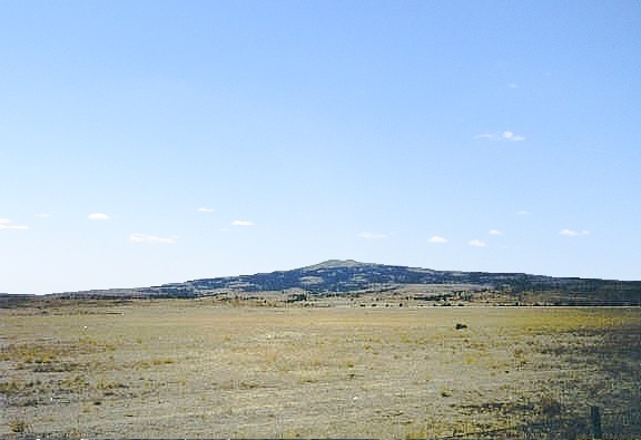 Sierra Grande from the east
|
Date: May 26, 2002
• Elevation: 8,720 feet
• Prominence: 1,880 feet
• Distance: 1 mile
• Time: 45 minute hike
• Gain: 550 feet
• Conditions: Clear but humid
New Mexico
•
PB
I was on the first day of a week-long driving and hiking vacation loop through New Mexico, Texas, Oklahoma, Colorado and Utah. Yesterday, I drove from Arizona all the way past Albuquerque and nearly into Colorado, when I pulled off the interstate and found a pullout in the middle of nowhere to park. I slept a couple hours in the back of my truck, awaking to the sound of birds. I was now in the high plains of Union County, New Mexico.
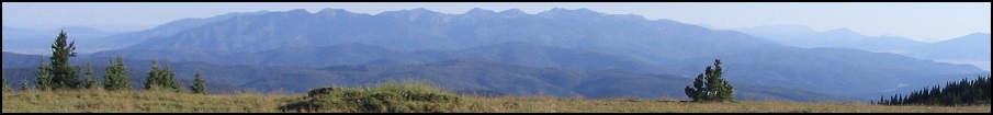
Union County is in the northeast corner of the state, bordering Colorado, Oklahoma and Texas. The land is high-elevation plains, cut by many rivers and creeks and by a number of rocky volcanic "plugs", some that jut dramatically directly above the land. The highest point is atop Sierra Grande, a broad and symmetric conical summit that rises nearly 2,000 feet above the plains. It can be seen from miles around and is an impressive sight.
My goal for now was to find a way to climb Sierra Grande. Naturally, I tried the roads closest to the peak, but found them to be gated closed, or if open, I could only drive in so far before getting blocked. I exited and tried to follow a narrow strip of state trust land on the east side. I went through more gates and found myself in a rocky pasture that didn't feel right. I backed out and drove into the tiny community of Des Moines, and started asking around. On the west end of town at a gas station, the lady mentioned a ranch-retreat center called the Mandala Center, which I had seen coming into town. She mentioned this as a lead, so I went there to check it out.
I drove the roads into the Mandala Center and came upon modernistic "new-age" buildings, but no people. I drove randomly around the roads hoping one just might go to the top, but all led to dead ends. I was giving up hope when, as I was exiting, an SUV pulled in. We rolled down our windows to chat, and it turns out the lady driving the SUV was the owner of the Mandala Center, and that she lived next door (so to speak) at the AR Ranch a mile or two west. When I explained my intentions, she kindly gave me permission to cross her property to the peak.
I drove west to the AR gates, entered onto the property, and following her directions, veered right from the main road onto rougher roads that bent around low hills in such a way that it seemed to go away from the peak. The road was rough and covered in big rocks, so I needed 4-wheel drive and had to go slow. In time, the road bent back toward the peak and started to gain up the slopes. I passed through a couple gates, one looking like it was completely thrashed. I was able to drive about 80% up the road, parking at a small clearing where I had room to turn my truck around. From here, I would walk the remainder, only about a half-mile, but with over 500 feet of gain.
The hike itself went quickly and without incident. I arrived to the summit area after 20 minutes and spent about the same time inspecting the flat summit for the actual highest point. There are a few buildings and towers atop Sierra Grande, but not so many as to upset the overall views. The view was amazing, with 360-degree views over the grassy plains, and the bigger mountains to the west. The weather was holding steady and slightly humid. I was back to my truck after a 10-minute descent.
The drive down was slow but straightforward, and I exited the property and back onto the state highways. I was happy to have had success on Sierra Grande and relieved not to have had to climb it via the state trust strip, which looked long and tedious. From here, I headed east toward Clayton, then popped into Texas near the community of Texline. For the rest of today, I visited a couple more north-Texas plains county highpoints, starting with Dallam County, proceeding east while evading giant panhandle thunderstorms, ending my day in Elk City, Oklahoma.
Important information: The following information is from David Eck, of the New Mexico State Land Office, regarding the status of the state trust land that leads to the summit from the east side, as well as lands surrounding the summit itself:
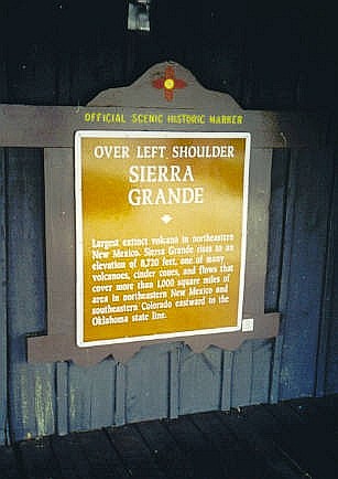
The summit, and a majority of the slopes of Sierra Grande are state trust land. It is important to note that state trust land is not in fact public land, and that all authorized access to trust land is only via the written permission of the head of my agency (whose official title, which is admittedly confusing, is the "Commissioner of Public Lands"). Our neighbors and lessees are not empowered to authorize access to the mountain. Point your browser to www.nmstatelands.org for more information about the New Mexico State Land Office and state trust land.
|
|