The Mountains of New Mexico
www.surgent.net |
 Eddy County's highpoint
|
Dog Canyon Overlook Peak • One Tree Hill I was touring New Mexico for a few days and found myself in Carlsbad mainly to dodge a snowstorm that moved through the state two days ago. I took the time to visit the Carlsbad Caverns and to drive around and look at things, including over the state line in Texas. I stayed last night in Kermit, Texas.
Date: March 17, 2000
• Elevation: 7,480 feet
• Prominence: 380 feet
• Distance: 4 miles
• Time: 4 hours
• Gain: 1,500 feet gross
• Conditions: Pleasant and a little warm
New Mexico
•
PB
Today started clear and warm, and any hint there had been a snowstorm two days ago completely vanished. From Kermit, I drove back into New Mexico, with two mid-size peaks on the agenda. First up was a peak-bump along the Dog Canyon Rim, highpoint of Eddy County.
I backtracked north up US-285 through Carlsbad, then a few miles north and a left on state route NM-137, a nearly 50-mile "dead end" highway that leads to the Dog Canyon (North) Entrance of the Guadalupe Mountains National Park. This highway is scenic as it passes through the hills of the Guadalupe Range, with many side roads leading every-which-way, including some notable waterfalls in the area.
My goal was Lincoln Forest Road 540, located 38 miles in from where NM-137 branched off of US-285. I went south on FR-540 for 9 miles, following a well-maintained gravel road, being sure to take it slow as there were many deer out today. I came to a turn-around, then drove another half-mile south on very rough road, parking at a convenient spot, elevation just over 7,200 feet. It was 9 a.m. when I parked in warm (high 60s), sunny and dry weather.
I walked the road (FR-3008) south for a mile to a point where it turned west. Here, I had two options: drop 800 feet into North McKittrick Canyon, then ascend the other side and up cliff bands to the highpoint, or walk west on the road, then side-hill past an intervening peak to the objective. Both options meant almost all cross-country travel, through grasses, scrub and sections of trees.
I went with the first option. I hiked a little west of Point 7,413, then entered through the trees and back into the open, overlooking an 800-foot drop into the canyon. I poked my way down through the grassy scrub and limestone rocks that conveniently formed steps. I was soon in the canyon, elevation about 6,600 feet.
Next, I ascended to a saddle (elevation 6,820 feet) south of Peak 7,139, which placed me north of my intended peak. I angled a little too far left and approached the top from its north-east facing slopes, which involved some short cliffs about ten feet high. Once on top, I needed to locate the highest point. The top is somewhat flat and torn up with brush and rockpiles, so I meandered around a little more than I would have preferred.
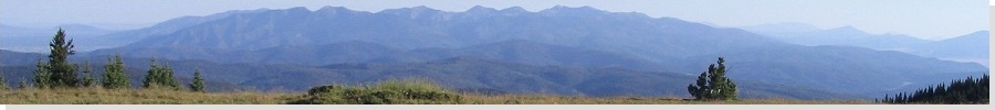
Finally, I found the highest point, marked with a wooden fencepost leaning amid a rubbly cairn. I found a sign-in register, and I knew I had the right place. Only four names had been entered since 1998, and I knew all four, wouldn't you know. With mine, the register now held five names. The views were good, looking over remote New Mexico and West Texas outback where no one goes to. There were some higher peaks to the south, over the state line in Texas. I was just a mile north of the state line.
It had taken me two hours to reach the top, encompassing 2.5 miles and a gross gain of nearly a thousand feet. I spent about 20 minutes up here. Going back, though, was not going to be as simple as retracing my route. I had carefully memorized notable features so that I could navigate my way out.
I descended back to the saddle, staying high on the ridge which was far easier than what I had done coming up. I dropped into the canyon and up the opposite side, keeping a bearing on the various visual cues. This worked well and I was soon back on the road and to my truck. The outbound hike had also encompassed about 800 feet of elevation gain, and I was fairly beat and scratched after this hike.
After a stop in Artesia for lunch, I went west and later in the day, I visited One Tree Peak, the Chaves County highpoint.
Date: March 17, 2000
• Elevation: 7,089 feet
• Prominence: 649 feet
• Distance: 4 miles
• Time: 1 hour, 15 minutes
• Gain: 900 feet
• Conditions: Lovely
PB
One Tree Peak is the highest point in Chaves County, in an appendage of the county that extends southwest into the Sacramento Mountains. It's a hilly mound, covered in juniper and pine, and were it not for its county highpoint status, not very remarkable.
I drove west through Artesia along US-82, aiming for Cloudcroft. At the small town of Dunken, I went south on state route NM-24, then onto Cuevo Canyon Road (dirt) west into the hills. Another eight miles later, I went south on Chimney Lake Road, then followed that to Sunflower Canyon, and parked. It was about 4 p.m., the weather pleasant and still, a nice change after yesterday's fast-moving storm.
One Tree Peak sits back about a mile from the road, forming the peak above the headwall of Sunflower Canyon. The area is fenced and is used for grazing, but there were no signs on the fence, no cattle anywhere, and nobody around to tell me to get lost. So I hopped the fence and started walking.
I walked east, following tire ruts and within 15 minutes, had arrived to the base of the peak. I then charged uphill, wending my way through the sporadic trees. The grades were easy at first, then a steeper higher up. The last couple-hundred feet of gain was up steeper, grassier slopes. But it was all easy, and I was on top at 4:40 p.m., a 900 foot gain from my truck.
The summit was as expected: a smallish hump of grass and rocks. In the register were the same four names as were in the Eddy County register earlier today, so I added mine. The views were nice, with flat plains to the east, and lots of hills and bigger peaks north and west. I stayed here ten minutes before moving downward. The hike down was quick and I was back to my truck by 5:15 p.m.. Although it was still light, the sun was now behind the western peaks and I wanted to be back onto paved highway before dark, which at this time of year came quickly.
I stayed on the main road as it followed a circular clock-wise route through forest, hills and occasional ranch properties. The drive went well but slow, and it was nearly dark when I arrived back on the paved roads near Cloudcroft. I descended the highway into Alamogordo and stayed there for the night, driving home the next day, the end of a successful trip into New Mexico.
|


|