
The Mountains of New Mexico
www.surgent.net |
| Sierra de Cristo Rey |
• Highpoint: City of Sunland Park • Sierra Juarez (outlier) • Doña Ana County |
|
Date: December 25, 2023
• Elevation: 4,675 feet
• Prominence: 738 feet
• Distance: 4.8 miles
• Time: 1 hour, 50 minutes
• Gain: 765 feet
• Conditions: Sunny, clear and cold
New Mexico
•
Main
•
PB
•
LoJ
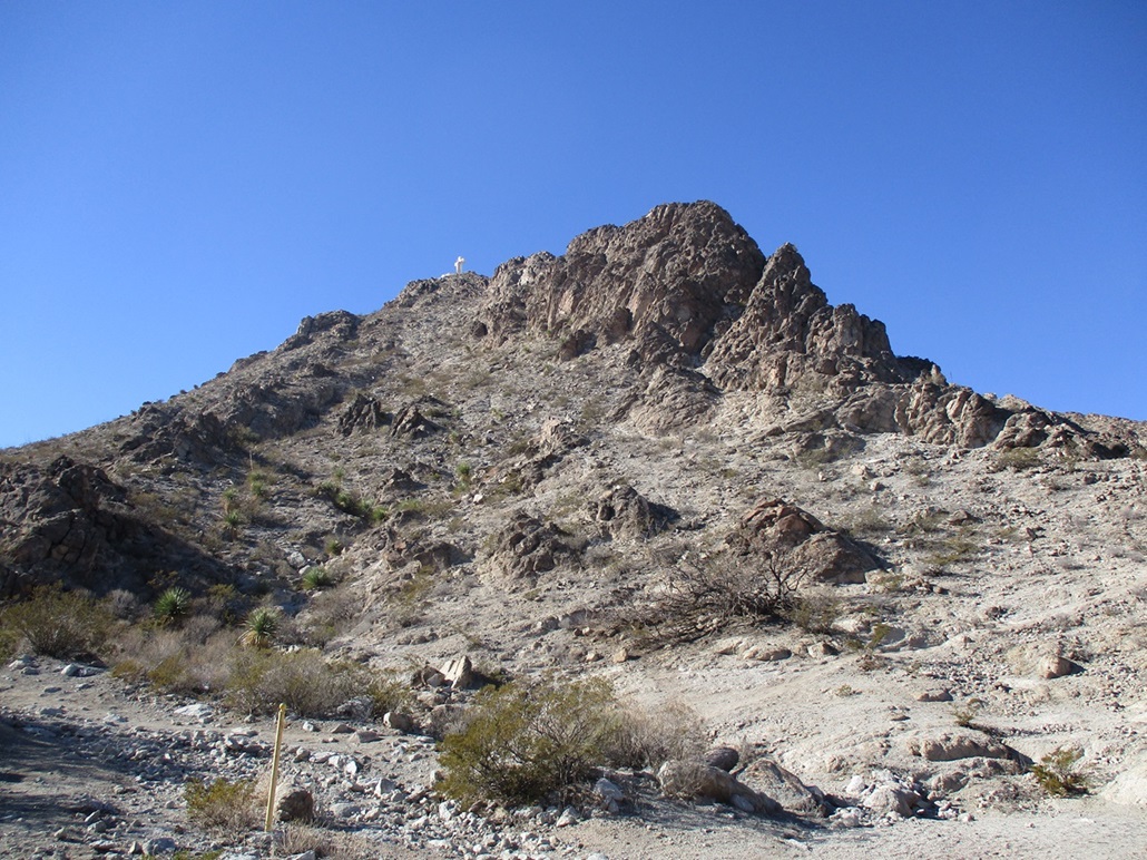
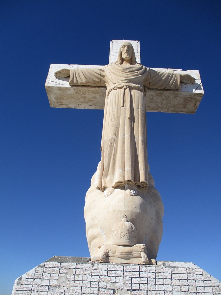
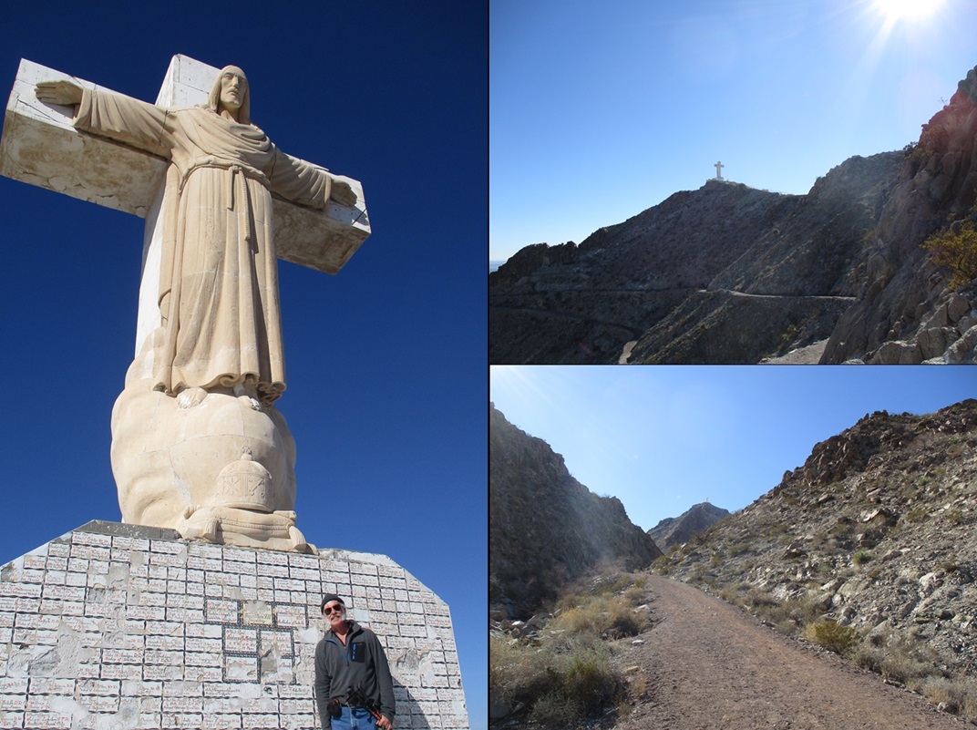
Sierra de Cristo Rey (Mount of Christ the King) is a rocky peak in the town of Sunland Park, New Mexico, tucked into a corner about a quarter-mile north of the Mexican border and less than a mile west of the Texas state line. The peak is the northernmost hill of the Sierra Juarez, which rise south inside Mexico, surrounded by the city of Juarez. The peak is famous for its 40-foot statue of Jesus on the Cross at the summit. It's been there since 1939 and is the site of a yearly pilgrimmage among local Catholics, sometimes over a thousand people on the trails at once.
I recently moved to Bisbee, Arizona, full time. With the winter break from teaching, I had some time to enjoy the holidays. I decided to drive out to El Paso/Las Cruces and spend a couple days in the area hiking peaks. I have not been in El Paso since 2005, and anywhere close to Las Cruces since 2007, and that was just passing through. The distance from Bisbee to El Paso is about the same as from Bisbee to Phoenix.
I monitored the weather and waited for a spell of clear, dry conditions. It turned out that right over Christmas day itself would be best. So I made hotel arrangements, packed the car and hit the road at 6 a.m. on Christmas day. I followed AZ-80 through Douglas then northeast into New Mexico, now signed as NM-80, catching state route NM-9 a few miles north of the town of Rodeo.
Route NM-9 runs along the southern tier of the state, at times less than a mile from the Mexican border. I last drove it in its entirety in 2004, and in bits and pieces since, but rarely. It's a remote highway, passing through only one town of any size, which is Columbus. It passes through two other towns, Animas and Hachita, neither of which have a population more than 50.
Being Christmas day and still early in the morning, no one was on the highway. For the 88 miles from where it leaves NM-80 to Columbus, not a single car came the other way, and I tailed just one car for a few miles, before he turned off in Hachita. No one passed me and I passed no one.
In Columbus, I wanted to stop for a snack. There's a Valero gas station near where NM-9 passes over the other main highway, the one going to Deming to the north, or the border about two miles to the south. But the gas station minimart was closed. Columbus feels like it's on the edge of the world. A very scraggly, quiet place, where the wind whistles through the streets.
I stayed on NM-9 until it hit the Doña Ana County line, where for some reason, state maintenance stops and the county takes over, now named Doña Ana County Road 3. I stayed on this road until I hit the outskirts of Sunland Park. I also encountered "traffic", about five vehicles total. I never saw a trooper, and since the highway is mostly flat with long straightaways, it was bound to happen that some guy would pass me at a hundred. I was moving nearly 80 miles per hour and he whizzed right past me.
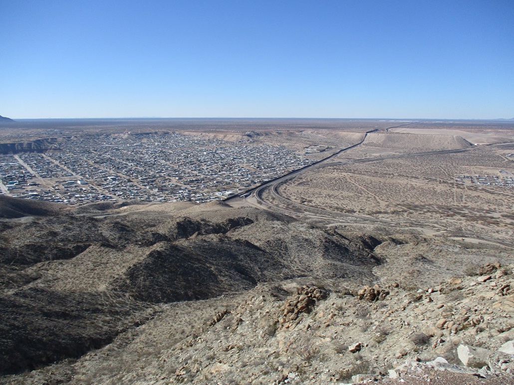
I could also see the peak in the distance, a craggy conical-shaped peak with steep slopes. I was too far to see the cross, though, and the sun was that way so I had background glare to deal with. I got onto the Pete Domenici Highway, which runs from the Santa Teresa Port of Entry with Mexico, north then east into Sunland Park and El Paso.
Sunland Park incorporated about 40 years ago as an amalgamation of a few of the smaller towns that were already here. It is most well-known for its racetrack and casino. Although in New Mexico, it is completely a suburb of El Paso, physically and culturally. The state line wiggles through town and is often not marked. I assumed the Rio Grande was the boundary but it is not.
I located myself onto McNutt Road, which runs to the southeast. Just before entering into Texas, a side road leads uphill toward the peak. It was 9:30 a.m. when I rolled in, having driven 220 miles to get here. When the big pilgrimmage is going on, there is a lot nearby that can hold hundreds of cars. Otherwise, the road is gated short of the lot and trailhead, but there is room to park alongside the road. I was the fourth car there.
Being so close to the border, the city asks that you check in with the police department (the number is provided on a sign, Do NOT call 911!) before starting a hike. The border patrol keeps a presence here, too. The approach and trail are such that it would not be likely to see some random Mexican crosser. From the Mexico side, it's some very steep terrain, and there are easier (relatively speaking) ways to cross the border nearby. Nevertheless, I felt it prudent to register with the Sunland Park PD, and pay attention. However, I did not feel anxious or worried.
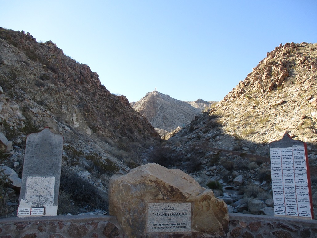
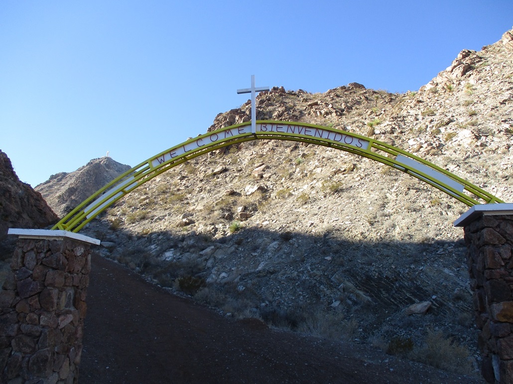
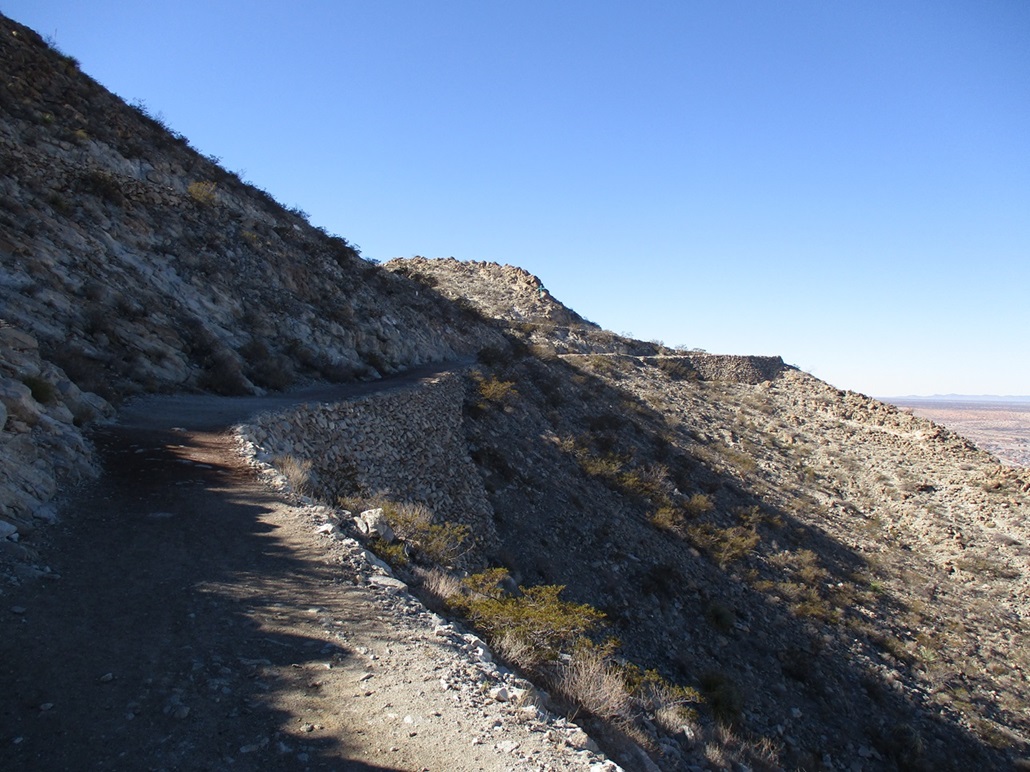
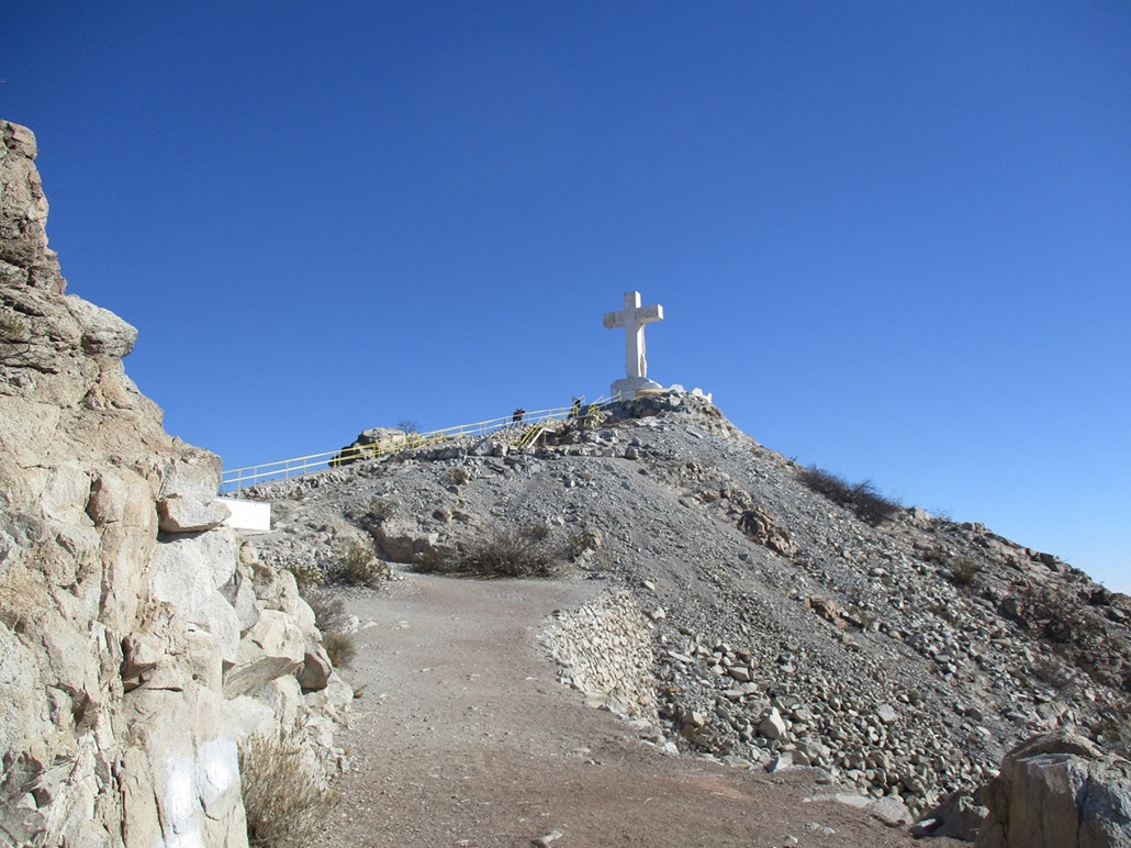
I walked past the lower gate up to the trailhead, where there is an archway and a couple nearby plaques. The summit and the statue can be seen in the space between two foreground slope cliffs. The trail is about as robust and well-constructed a trail as I've ever seen. It's essentially a road about ten feet wide, and pitched extremely leniently, covered in a soft layer of gravel chat. Although the summit is less than a half-mile away on a straight line, the trail makes such long switchbacks so that the actual mileage one way is close to two and a half miles.
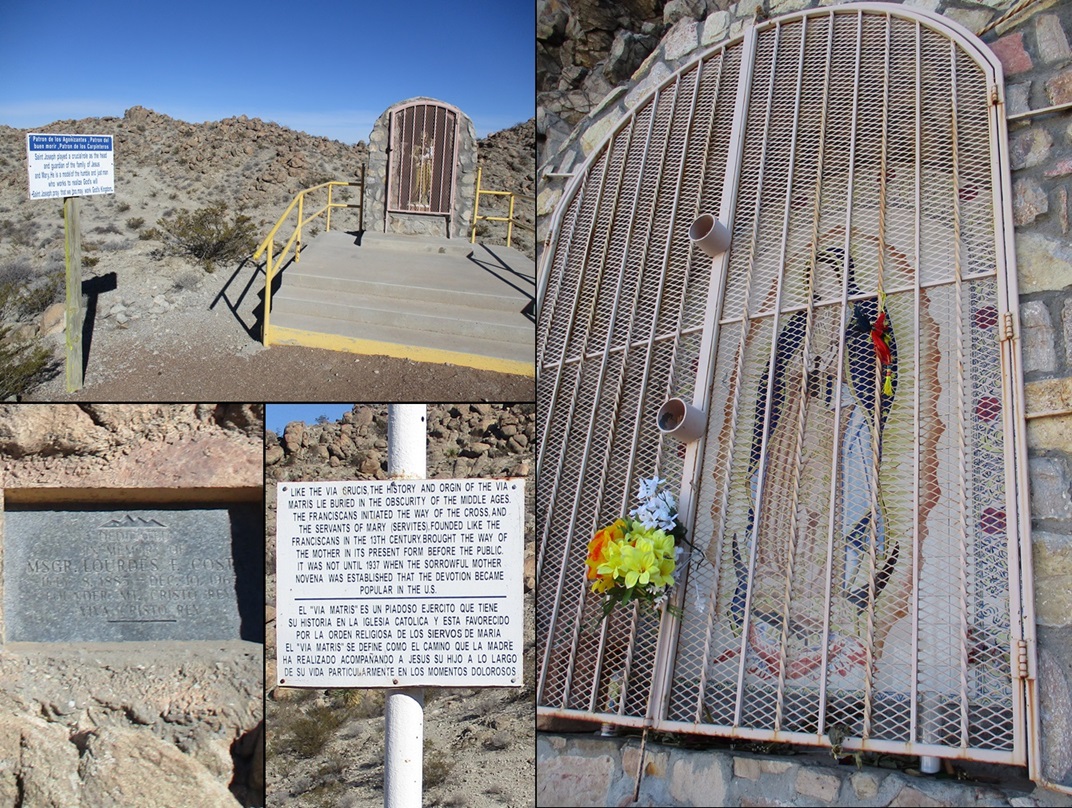
I started walking, taking my time and enjoying the shrines and signs posted alongside the route. There's a smallish one for Joseph, lower down. Later, at one of the switchback bends, there's a plaque for Msgr. Lourdes Costa, a priest and later a Monsignor, who was behind the development of the mountain as a shrine and a pilgrimmage site. I found the following on a website:
Father Lourdes F. Costa arrived in El Paso, Texas in 1912. He was a local parish priest of the Smeltertown Church of San Jose for twenty years, when the Pope summoned parishes in all parts of the world to build sacrosancts or material monuments. Father Costa envisioned a statue on top of the Sierra de Cristo Rey (formerly known as the Cerro de los Muleros, Mule Drivers Mountain), in Sunland Park, New Mexico. He turned in the direction of the conical peak outside of his window every morning. He always thought that such a location was a perfect setting for a monument to Christ the King, the Prince of Peace. First, a twelve foot high wooden cross was erected in 1933 and a couple of month later it was replaced by an iron cross. In 1939, a 29 ft. tall limestone statue of Christ by sculptor Urbici Soler was erected on top of Mount Cristo Rey. It can be seen from all three states and it serves as a shrine to thousands of faithful in the El Paso and Southern New Mexico area. Consequently, Father Costa had realized his dream to inspire the people who live at the crossroads of three states with a lasting symbol of hope and peace. (source)
The trail itself is extremely impressive. This is not some gentle hill, but a rocky peak with aggressive slopes and plentiful cliffs. In the old days, the pilgrimmage took place on looser, scanter paths one might expect on a typical mountain. (The image on the Wikipedia site appears to have been taken before the trail was upgraded). In places, stone bulwarks about 20 feet high were put in place to support a trail. I shot an image of one, but they were everywhere along the way. Why can't all mountains have such fine trails like this?
I rounded a couple last bends and finally saw the statue, now much closer. The route approaches it from the west, whereas the statue faces east toward El Paso. I walked up a long concrete ramp to the viewing platform and the substantial base. The statue itself is about 30 feet high, and the base another ten feet high, covered in tiles commemmorating donors, benefactors, some notables of the region from that era (1930s-40s), and a few more recent, some dating to just last year.
There was a couple there, and they were very friendly, both from El Paso. They both have hiked this peak many times and had stories to tell. The man told me that the trail was "recently" redone into what we see today. The tiles on the base have decayed, some chipped off, some completely off. The statue itself is in fine shape. It's of Jesus, with his arms outstretched on the cross' crossbeam, but because his palms face down, he is blessing us, not being crucified. This Jesus is wearing full robes and looks healthy. My guess is they wanted the cross but not that of the actual crucifixion. I read up on the sculptor and how he actually created the statue. You can see that the statue is composed of large blocks. It's not one continuous piece of limestone. Apparently he would winch the block into place then go about sculpting it into shape.
I spent almost a half hour up here chatting with the couple. Another guy showed up soon thereafter. The couple were totally cool and knowledgeable. They're from El Paso. I mentioned I lived in El Paso way way way back in the olden days. They thought that was cool. I was just a baby, though. I have no first-hand memories of El Paso.
I was raised nominally a Catholic, so this kind of iconography is familiar to me. The elaborate statues, the colorful votive candles and items laid at the base, the quasi-medieval imagery, this is all what I grew up with when we went to church. I stopped practicing it when I was older, but being here on Christmas day was actualy special to me. My mother was Catholic, then went through her years of not practicing, but then started to attend church again in her final days. On her 80th birthday two years ago, I found a local Catholic church in Tempe and sat in the auditorium, this not being during a service. It was just me in there. It was the first time I was inside an actual church (not counting weddings) since 1985. It allowed me a chance to grieve for my mother and by extension, my grandmother, because I knew the church was important to them. So being here today, I thought of my mom and grandma. This one's for you two.
I bid the couple goodbye and hearty thanks, and started down. I made good time on the lovely trail. I made one side trip to view the shrine of Mary. This one was off the main trail up a side trail and stairs, built into the rock. It's the familiar Mary statue with the colorful aura and robes, but unfortunately, behind a metal grate fence presumably to keep from being vandalized.
By now, more people were coming up, and when I was back to the ad-hoc trailhead, there were now well over twenty cars parked every-which-where. I looked at the plates and over half were from Texas. I called the Sunland Park PD to let them know I was down, then got into my car and left. I had been on the mountain just shy of two hours, and enjoyed every minute of it. Not every peak has to be some epic route-finding, scrambling, bushwhacking ordeal. This was about as easy a peak to scale, but the reward was a very spiritual one, even for a non-church-going fellow like me. Merry Christmas!
From here, I somehow found my way onto Interstate-10. I had forgotten Texas does a poor job of signing its roads. They're working on the interstate and in spots was just one lane wide. But traffic was minimal because it being Christmas. I drove north (technically, "westbound") into Las Cruces, then made my way to my next peak, Tortugas Mountain, which, believe it or not, also has Catholic shrines and is a pilgrimmage site as well.
|

|