The Mountains of New Mexico
www.surgent.net |
| Beautiful Mountain |
• Highpoint: San Juan County • Chuska Mountains • Navajo Indian Reservation |
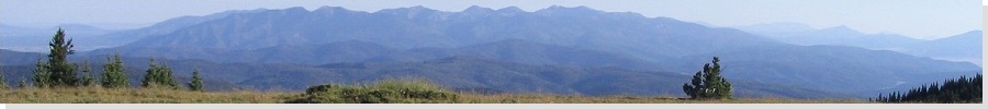
 Summit shot, October 2002
|
Date: (1) October 1, 2002; (2) July 11, 2010
• Elevation: 9,388 feet
• Prominence: 1,508 feet
• Distance: 2 to 3 miles
• Time: 2 hours on average
• Gain: 900 to 1,100 feet
• Conditions: (1) Unsettled with storms in 2002, much nicer in 2010
• Teammates: Adam Helman in 2002; Scott Casterlin, Scott Peavy and Chris Gilsdorf in 2010
New Mexico
•
PB
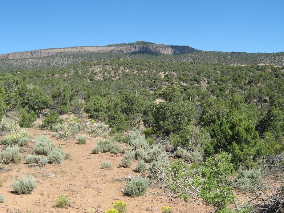
Beautiful Mountain is an isolated peak in northwest New Mexico on the Navajo Indian Reservation. The peak rises above the town of Sanostee, and is actually a part of the Chuska Mountains, which lie mostly in Arizona.
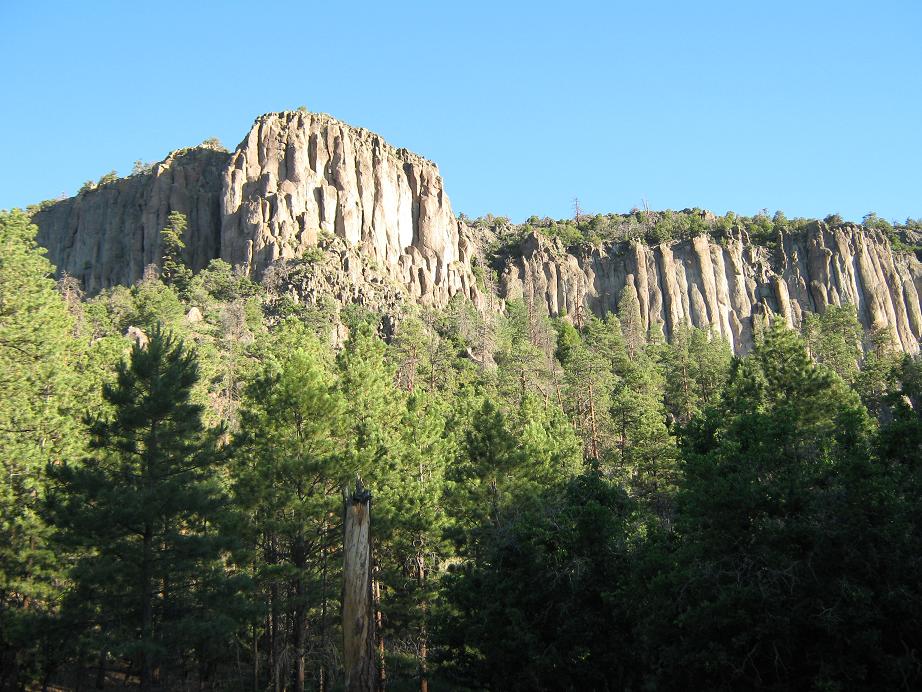
Few people come this far to hike the peak, its status as San Juan County's highpoint drawing some attention from hikers. The peak is surrounded on all sides by fluted cliffs, but a breach in these cliffs permits a rough path to the top. Roads get close so that the hike is short, but it is remote and the roads are not the very best. I have been to the top twice, once in 2002, then again in 2010.
First Visit (October 2002): Adam Helman was spending a week in New Mexico hiking the county highpoints, so we agreed to synch our schedules so I could meet him for this peak. Due to a fluke in my teaching schedule, I had Tuesdays open. I left work Monday afternoon and drove 265 miles to Gallup, New Mexico, meeting Adam at a Motel-6, where we crashed.
We left the next morning before dawn, me stashing my truck at the local Wal-Mart, and sitting shotgun in Adam's new Toyota Tacoma. We drove north on US-666 (now US-491) for 60+ miles through the beautiful high desert. The sun rose as we neared our turn-off, BIA Route N-34, which leads into Sanostee.
Being off the main highways, no one comes to Sanostee as a tourist. It is a tidy town laid out in a grid with a church and basic shops, surrounded by fields with sheep, cattle and crops. Past Sanostee, Road N-34 turns to dirt. We followed this road 4.7 miles to Road 5013, then northwest on 5013 for 5.5 miles to a junction marked by a stone column on the right. The roads were getting rough and gaining considerable elevation, although we did not need 4-wheel drive yet.
At the stone column junction, we went right onto a rougher road for 2.6 miles, going right at two junctions and left at a third junction, parking in an open clearing south of the peak itself, below its impressive cliff bulwarks. Adam got valuable practice using 4-wheel drive on these last roads, including one stretch with an intimidating sideways lean to it.
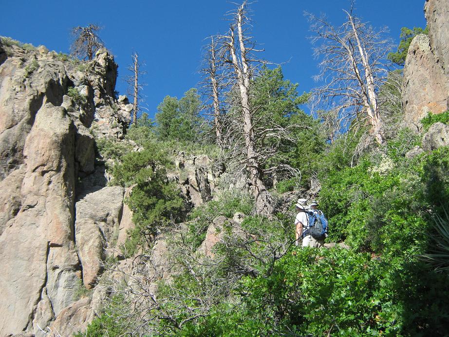
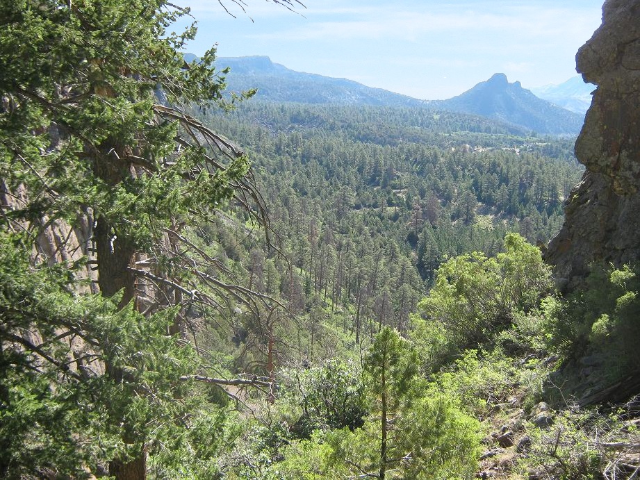
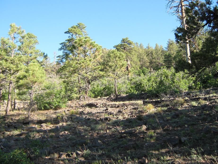
The hike is short, but steep and strenuous. From where we parked, we hiked directly up a hill to the north, gaining 150 feet. From here, we had a commanding view of our objective. We could see a steep slope leading up a break in the cliffs. Getting there meant bashing through brush, although as we got closer we came upon a rough path. The path wormed its way up the steep slope in this breach, allowing us passage onto the upper plateau of Beautiful Mountain. We made note of landmarks and Adam took a compass bearing so we could find it on the way back.
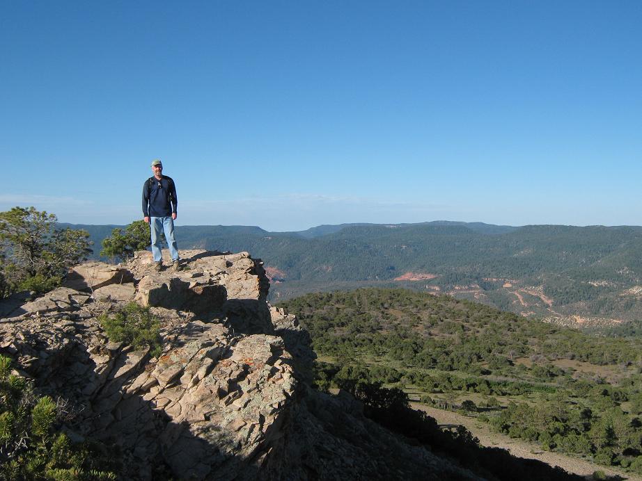
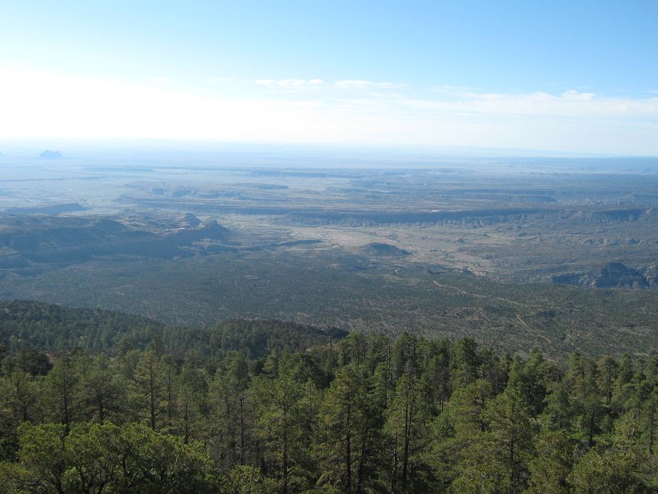
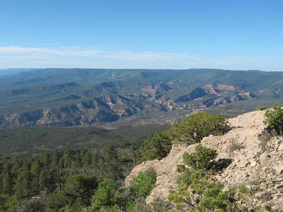
From this point, the summit is sometimes visible through the trees. We started up the hillside, the tree cover lessened, the hill grew steeper and sometimes crumbly, and we hiked toward a rock outcrop which turned out to be the top. The top was small but pronounced, with great views in all directions. To the east was the flatness of the high plateau, with rock monolithic "inselbergs" poking up above the flats. The most famous of them all, Shiprock, was visible to the northeast, partially obscured by Beautiful Mountain's large and extensive plateau.
It was cold and windy on top, cool enough to force us to start moving quickly. The weather was unsettled. After 20 minutes, we started our hike back to the truck. We had no problem at all navigating by reckoning through the trees back to the cliff-breach. Going down was a little tricky for me, as my left knee would tighten, a residue of a biking fall I experienced a month earlier. The hike back to the truck took 40 minutes, for a total round trip of less than two hours. We covered about 2 miles round trip with 950 feet of gain.
Back at Adam's truck, we didn't delay, starting the drive out immediately. We had to pay close attention to the junctions, but at one point, we came to a Y-junction that confused us at first. We took the left fork down to a good road that lead us to an intersection with another "good" road, but neither of us could be sure if it was our correct route out, so we turned back and went up the way we came back to the first Y-junction. Adam was getting kind of spooked driving down these roads so I took over.
From our junction, I drove down the other road, which seemed unfamiliar at first, until I saw rock piles that I'd noticed coming up. So we went out that way and came out to an intersection, the one we were just at a few minutes ago (!). We hustled out to Road 5013, just as the weather turned gray and started to rain. We had no desire to be on these roads in wet conditions. I drove us out to Sanostee and pavement. There, Adam drove us another 20 miles to a gas station on the main highway where he bought a pint of ice cream. I then drove us back to Gallup while he ate the whole thing. The rain picked up so we were happy to be back on pavement and off the mountain, just in time. I picked up my truck in Gallup then spent the rest of the day driving home, arriving about 4:30 p.m. My thanks to Adam for working his schedule to include me on this little adventure.
The next day I became an uncle again as my brother and his wife welcomed their new son into the world. The following weekend I made the drive out to SoCal to meet my new nephew!
Second Visit (July 2010): This was the last peak of four that we (Scott Casterlin, Scott Peavy, Chris Gilsdorf and me) visited during a weekend of driving and hiking in the Four Corners region. Yesterday we had been successful on Pastora Peak in Arizona and on Abajo Peak in Utah. Late yesterday Scott P. and Chris hiked up Roof Butte in Arizona, while Scott C. and I passed on it.
We then drove in the evening twilight up the dirt roads from Sanostee to the base of Beautiful Mountain. The route was the same as Adam and I took in 2002, there being no alternatives. We arrived in darkness and camped in a clearing south of the summit. The night was clear and still, and warm for 8,300 feet. I was eager to re-hike this peak. It's short but steep and fun, and I wanted better photographs.
We started early this morning, walking up a lesser road that paralleled our "main" road. This lesser road is undriveable but leads into the forest, putting us close to the break in the cliffs. We covered this stretch in less than 30 minutes. Then, we hiked down easy draws and up onto the slopes below the big break. In time we found the use-path that worked its way up on top of the plateau, and from here, hiked up the slopes to top out on Beautiful Mountain. It took us a shade over an hour, mainly since we started farther out than Adam and I did in 2002.
The summit is bare and rocky, overlooking the broad flat plateau-top of Beautiful Mountain. We had spectacular conditions and enjoyed the crystal-clear views of the surrounding mountains: Pastora, Ute, Abajo and even the La Sals to the north, Roof Butte to the west, high-desert rangeland and mesas to the east, canyons and cliffs to the south, and Shiprock partially obscured to the immediate east. We spent awhile up top, enjoying the views. I was happy to be up here again.
The hike down went well, the only variation being we cut south to the main road and hiked it back to our vehicle, the round-trip time being about 2.5 hours. After breaking camp and relaxing a bit, we started the drive out, which went well. In time we were back in Sanostee, our peaks done and now, just the long drive back home. Instead of driving through boring Gallup, we took a side route over Narbona Pass to Window Rock, where we toured the well-done memorial at the Window Rock Tribal Park. We had a lunch in town, then continued on our way home via Holbrook and Payson.
The drive was eventful: we got caught in stalled traffic on the AZ-260 east of Payson along the Mogollon Rim. The monsoon thunderstorms had been strong here and dropped a lot of rain, spawning a mudslide that covered the highway for a few hours. Lots of people were turning around, while we took "Control Road" that arcs north of Payson, catching Houston Mesa Road back into Payson, bypassing the traffic. This added an hour to our journey. The rest of the drive was uneventful, and I was happy to be back home, and happier to have had a successful weekend with two new peaks for me, a cool repeat, and good times with cool partners. My thanks to Scott C., Scott P. and Chris ("honorary Scott").
|

|