
North Dakota
• www.surgent.net
|
| White Butte |
• Highpoint: State of North Dakota • Highpoint: Slope County • Highpoint: Chalky Buttes • Highpoint: Little Missouri National Grassland |
|
Date: August 8, 2002
• Elevation: 3,506 feet
• Prominence: 546 feet
• Distance: 1 mile
• Time: 1 hour
• Gain: 400 feet
• Conditions: Generally overcast and cool
Main
•
PB
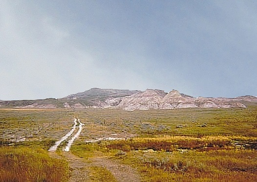
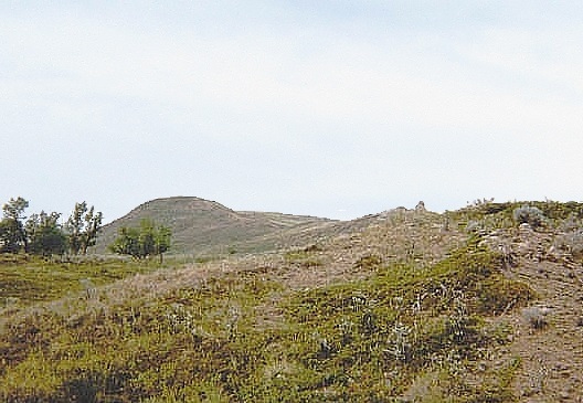
North Dakota's highest point is a bluff called White Butte, located in the southwest part of the state. The hill rises above the grasslands of the Great Northern Plains, part of a small range called the Chalky Buttes. The hill is notable for its soft, chalk-like dirt that becomes hopelessly slick if wet, and for the abundance of rattlesnakes in the area.
I was up in this general part of the country climbing Montana's Granite Peak, with a team of nine. After descending, we convoyed into Wyoming, where we planned to climb another peak. I was not eager to backpack another three or four days for a peak that did not interest me. Thus, that morning, I declined to join the others, thanked everyone heartily, and went on my way. Not that they needed me. The peak was fairly technical and I would have been ballast.
So now I had a few days to kill. I decided to head east and check out two things: the righteous Sturgis Motorcycle Rally, then head up to North Dakota and hike its highpoint. This was a golden opportunity to hike it, given that I never get to this part of the country for any reason.
I spent most of yesterday driving east across the high plains of northern Wyoming, enjoying the wide-open vistas, vast seas of grass and green, meditative silence ... and bikers. The closer in to South Dakota I got, the more bikers that seemed to appear out of the ether.
I detoured off the main highways to visit Devil's Tower, the famous volcanic plug with its fluted sides. I had no intention to climb it. I just wanted to walk around, look up at it, contemplate it and ... hang with the bikers. There were hundreds of them. They all park in long rows then get out and stand around. Everyone was cool.
Soon, I was in Sturgis proper. There were thousands of bikers from all over the world. Many were weekend warriors, others the real deal, from the major "one-percenter" clubs with their colors and vibe. The main drag was choked with bikers and their hogs. And me, in my lame little rental sedan. I drove up and down the main street a couple times. It was amazing! On the fringes of town, people were setting up big tents and camping compounds. I knew I was not going to find a place to stay within a hundred miles.
I drove out of town after a couple hours and ate at a big roadhouse whose name I forget. There were bikers galore in this outfit. One lady sitting one table over was wearing the scantest bikini and her leathers. She was middle age and a knock out. I looked ... but made sure it wasn't too obvious I was looking. I did not need to rile up a bunch of bikers unnecessarily.
Anyway, I started heading north toward Belle Fourche, by now the sun having set. In the darkness, I sought a lonely road where I could pull aside to catch some sleep. I tried a few but never felt comfortable with any of them. Back on the main highway, I drove into a monster thunderstorm throwing down sheets of rain. So I pulled to the side of the highway to wait it out. Next thing I know, it's 3 a.m.. I'd fallen asleep for about 6 hours, right there in my front seat along the highway. Everything was dark, still and quiet. The storm had dissipated. I was genuinely surprised to have fallen asleep so soundly like that. I must have been quite tired.
I was just a few miles from the North Dakota border. I crossed into the state early today and with plans to hike a few county highpoints as well as the state highpoint. However, on my first attempt at a local county highpoint, the access road was nothing but mud, and my small vehicle was not up for these kind of roads. I decided to skip the county highpoints, go hike White Butte, then start driving back to Billings and head home.
White Butte is located in Slope County, on the state's west boundary with Montana. The county has a population in the hundreds, and the county seat, Amidon, has about 50 people. Driving into Amidon, I slowed down when I saw a cop car on the side of the road. Only then did I see there was a mannequin in the seat. Yeah, it fooled me. That was probably half the police force right there.
I pulled into a local market for drinks and general advice on the roads, then proceeded south to the highpoint. The gravel roads were sturdy enough for my little rental car, and after a few minutes, I arrived at the home of a woman named Ms. Van Daele, the landowner whose land includes White Butte, and who (at the time) required a $20 "donation" to park and hike to the highpoint. I paid it, talked to her briefly, then drove to the little parking area, and started my hike. She was friendly.
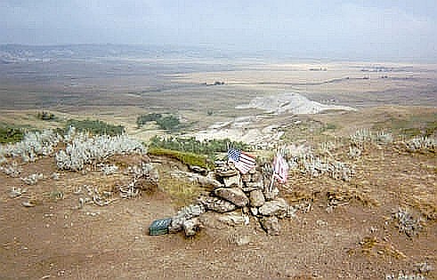
From the parking area, I walked south along a two-track etched into the grassy pasture. The exposed dirt was a chalky-silt sand, slightly sticky and gooey after the rains. Quickly, I came upon eroded foothills composed of this same chalky dirt. Getting up these proved to be tricky, since the slopes were slick. But it was only a few feet and I scampered up onto firmer ground. I then followed a good trail to the summit, marked by a small cairn, a flag and a strong-box.
The one-way hike had taken me 30 minutes, with 400 feet of gain. The sky was gray and it was breezy, so I didn't stay long. The views all around were of high plains prairie and the surrounding hills, some nearly as high as my position. I did not come across nor scare up any of the peak's most famous varmints: rattlesnakes. This peak is famous for its snakes, but today they were all in their snake holes. I did not object.
The hike down was easy until I came upon those chalky slopes. On cue, I slipped going down, landing on my side and caking my skin, my pants and my shirt in this thick, cement-like "dirt". I got back to my car, changed out of what I could, then drove to the Interstate where I went into the men's room at a truck stop and spent another twenty minutes trying to clean it off my skin. It was like concrete. My shirt was a goner, but I bagged my pants and hoped I could wash it out once back home.
I spent the remainder of the day driving back to Billings. It was a cool, blustery day, and I enjoyed the scenery. I had one amusing experience in Miles City: when I exited the interstate, some guy was standing about midway on the shoulder of the exit ramp. He had a backpack and a sign. He was obviously trying to get a ride, but had planted himself on an exit ramp, facing downhill, where all cars would be going the other way. Would he ever figure out his error? I had a lunch, then when I got back onto the interstate, I looked over and yup, there he was, still on the exit ramp, probably wondering why all the cars are going the other way.
White Butte was a fun and enjoyable excursion, a nice way to end the week after a big hike and climb up Granite Peak. I am happy I came this far to visit it, since I had no real plan to come this far for this particular highpoint on its own. I stayed the night in Billings and flew home the next day.
Post-script: Ms. Van Daele died sometime after my visit. The access is still largely the same, but clearly, the information here is old and should be taken for its historical purposes.
|

|