County Highpoints of North Carolina
• www.surgent.net
|
 Me on Mount Mitchell
|
Prologue: I visited North Carolina in May 2000, with Mount Mitchell as my primary goal, and whatever other peaks I could visit along the Blue Ridge Parkway. I was here for just a few days, and had to contend with intense storms and heavy fog, but the weather improved toward the end and I had a couple enjoyable hikes on the Appalachian Trail, plus meeting up with Fred Lobdell later on for a pair of highpoints here and in Tennessee.
Date: May 26, 2000
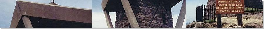
• Elevation: 6,684 feet
• Prominence: 6,089 feet
• Distance: 0.2 mile
• Time: 30 minutes
• Gain: 150 feet
• Conditions: Clear with haze and clouds
Main
•
PB
Mount Mitchell is the highest point in North Carolina and the highest point of the entire Appalachian Mountains, as well as the highest point in the United States east of the Mississippi River. Many trails and roads lead to this summit, which is a state park and a popular tourist destination. One can make a full-day hike of Mount Mitchell, or drive close to it and reduce the hike to just a short nature walk.
I arrived in Atlanta a few days ago, my plan being to visit six state highpoints in the Southeast, plus whatever county highpoints I could tag along the way. I had intended to visit Mount Mitchell two days ago, but encountered heavy fog on the drive to it. I backed off and stayed the night in nearby Asheville, but the next day started with heavy thunderstorms, so I bailed from North Carolina entirely and headed north into Virginia, before doubling back down south, which brings us to today.
I started today in Kingsport, Tennessee, and drove into the Appalachian Mountains. I hike Roan High Knob first, which you can read about below. From there, I drove south on the Blue Ridge Parkway to the spur road to Mount Mitchell State Park. I parked, and hiked a gravel path to the lookout and the sign marking the state highpoint.
There were a few people here at the moment, but it was not crowded. The weather was steady with clouds, some sun and a lot of humidity. I stayed here about a half hour. Although visiting Mount Mitchell required almost no effort, I knew I would be getting a lot of hiking and scratches before the day was over. I had the rest of the day allotted for a sequence of peaks alomng the Blue Ridge Parkway.
Date: May 26, 2000 •
Elevation: 6,285 feet • Prominence: 3,485 feet • Distance: 4.8 miles • Time: 2 hours • Gain: 700 feet
PB
Roan Mountain is a series of peaks along the Tennessee/North Carolina state line. On the Tennessee side, there is a state park with a Ranger Station, information kiosks and built-up areas for visitors. I drove in from the Tennessee side through the towns of Johnson City and Elizabethton, following the signs to Roan Mountain State Park. The Appalachian Trail is the principal hiking route through the park, and would be the trail I would follow to the summit.
Roan High Knob is the highest of the Roan summits. It lies on the state line and is the highpoint of Mitchell County (North Carolina) and Carter County (Tennessee). I parked at Carver's Gap, north and east of the peaks, and a let-in point for the Appalachian Trail. From the parking area, the trail gains steeply and is eroded in places, then the grade moderates via switchbacks before leveling off. Then the trail bends left and starts a slow descent. The highpoint is here somewhere... umm...
I knew something wasn't right, but I hiked onward anyway, coming to another parking area and a fee station. I asked the ladies in the booth where Roan High Knob was and they pointed it to me: right where I had come from. So I retraced my steps, hiked back the way I came, and found the turn-off to the summit. It's poorly marked and only visible for the northbound hikers, not for southbound hikers like I was. That's my excuse and I'm sticking by it.
It was an easy uphill stroll to the summit, marked by rock outcroppings, dense forest, and a nearby shelter (apparently, the highest one along the Appalachian Trail). In all, I added an extra 1.4 miles to the hike, making a 3.5-miler into a near 5-miler. Overall, the hike involved 700 feet of elevation gain and took me 2 hours. I drove down beautiful local highways and got myself onto the Blue Ridge Parkway, heading toward Mount Mitchell.
Date: May 26, 2000 •
Elevation: 5,665 feet • Prominence: 465 feet • Distance: 2 miles • Time: 40 minutes • Gain: 400 feet
PB
From where the Mount Mitchell road meets the Blue Ridge Parkway, I drove a half-mile "south" on the Blue Ridge Parkway, to a locked gate alongside the road. This is not an official hiking trail. Thus, there is no parking area here. I had to fit my car off the road and hoped no one would hit it.
I crossed the gate, and walked up a jeep road about 50 feet to a trail on my right. This trail quickly attains a ridge, along which it is another mile of steady uphill in the thick forest to the top. The last half-mile or so had "no trespassing" signs posted and an old barbed-wire fence that ran along the ridge, but I believe this only refers to the western slopes, as they lie inside the Asheville Watershed, which is known to be off-limits. I think the ridge itself is legal.
After 20 minutes, I came to a rocky jumble, the summit of this little peak and the highpoint of McDowell County. The county line crosses over the top of this peak. I stayed a few minutes, then proceeded back to my car and drove up the road to my next objective, Little Pisgah Mountain. Overall, this little sojourn covered two miles round trip and about 400 feet of gain in about 40 minutes.
Date: May 26, 2000 •
Elevation: 5,280 feet • Prominence: 160 feet • Distance: 1 mile • Time: 1 hour • Gain: 380 feet
PB
From The Pinnacle, I proceeded southbound on the Blue Ridge Parkway to Little Pisgah Mountain. There are two Pisgah Mountains: a little one and a big one. The big one is obviously more substantial and more popular, and most people in the parking lot were there to hike (Big) Pisgah Mountain.
I parked in the farthest lot (at milepost 407.7 off the Blue Ridge Parkway) and started in on the main trail ... toward Pisgah Mountain. The hike was nice but I realized I was actually hiking to the wrong peak, so I backtracked back to the parking lot and read the directions carefully this time.
The trail for Little Pisgah Mountain is located on the east side of the lot across from where the cars park. The trail is marked with white circles, and heads north. It is a short, easy half mile hike up the trail to the summit. The actual highest point is located just off the trail in thick growth, so I got down on the hands and knees and reached into the underbrush to tag the top. I did this around 4 p.m. in pleasant weather.
Only a county highpointer would ignore Pisgah Mountain for its "Little" neighbor. In retrospect, I should have hiked up the main peak too. Some day I will.
Date: May 26, 2000 •
Elevation: 6,025 feet • Prominence: 160 feet • Distance: 3 miles • Time: 1 hour • Gain: 560 feet
PB
It was pushing 5 p.m. when I started the hike up Chestnut Bald. Although the day had gone well, I had put in about 8 miles of hiking already, and a lot of driving. I still had energy, but I was also getting tired. I followed a paved path up a steep slope, hanging a left where I crossed a footbridge over the Parkway, catching the "Mountains to the Sea" trail. I stayed on this trail until it gained a broad ridge, then started to drop.
The summit is just 0.2 mile off the trail directly up-slope, but the growth is thick, with high grass, logs and brambles. Veteran east-coast hikers know to wear long pants, but I was in shorts, and I would suffer. The hike up went quickly and I gained the top in little time, but in the meantime, I shredded my legs badly.
Even up top I couldn't be sure I was at "the top", so I paced the ridge until I was satisfied that I had probably stomped on it at some point. Then I descended back to my car, bleeding like crazy. It's also no small wonder that I didn't get bit by a snake either. Or get a load of ticks. What was I thinking?
Date: May 26, 2000 •
Elevation: 6,410 feet • Prominence: 3,010 feet • Distance: 1.2 miles • Time: 40 minutes • Gain: 400 feet
PB
I arrived at the Haywood-Jackson parking area around 6:30 p.m. The trail begins at the north end of the lot, and is paved for the first thousand feet or so, then gives way to a dirt tread. Small wooden posts numbered 1-13 lead to the summit, presumably in conjunction with a trail-guide one can read when hiking this route (it's a developed "nature trail", but I didn't see any literature on it). I was still a bloody mess from my last hike when I started the hike. The minor hypovolemia helped clear my mind.
In zombie mode, I walked up the hill until I came to the summit, which has a bench and a big sign. It was of foggy, so I tagged the sign, and turned around. It's actually a pretty hike with plenty of views (when there's no fog or clouds), as well as being one of North Carolina's highest county highpoints. But I was dead tired by now and not really paying much attention to the sights.
After hiking down, I bailed from the Blue Ridge Parkway and stayed in a hotel in Wayneville. I've never been so ready for a shower as I was today. I bought a beer to drink but dropped it while fiddling with the doorknob to get in my hotel room, and spritzed precious beer all over the place. The shower felt great, my legs hurt like hell, soothed by Neosporin, and I settled in for a night of channel-surfing, minus the beer.
Date: May 27, 2000 •
Elevation: 6,643 feet • Prominence: 4,503 feet • Distance: 1 mile • Time: 1 hour • Gain: 200 feet
PB
I stayed the night in Wayneville, North Carolina, scratched and tired from yesterday's series of hikes along the Blue Ridge Parkway. I was up early, with Clingmans Dome first on my agenda. I headed into the Great Smoky Mountains National Park through the town of Cherokee, within the Cherokee Indian Reservation.
Every conceivable space in the town was devoted to advertising, souvenirs, restaurants, and eight-hundred other things. Thankfully, once I entered the National Park, the commercialism stopped, the trees resumed, and I could get back to the task of following slow R.V.s going 10 miles per hour up the slopes toward the high peaks ahead.
From the main highway, I followed another road south about six miles to a parking area below Clingmans Dome. Up here, the fog was thick, obscuring views. I walked a paved footpath to the top, tagged the top, hung around for a brief while, then returned to my vehicle. Someone took a blurry hotograph of me.
Interestingly, my entire "Tennessee Highpoint" experience was entirely within North Carolina, other than the moment I tagged the presumed top, which momentarily meant I was "in" Tennessee. With the fog, this was not a memorable experience. I'll come back when I am older, then I can be the slowpoke in an R.V.
I then drove toward Robbinsville (N.C.) where I met Fred Lobdell, a county highpointer celebrity. He has hiked many peaks in the region, and it was his notes that I used for my highpoints along the Blue Ridge Parkway. However, we both encountered delays into Robbinsville and didn't meet there. Instead we met at the Nantahala Forest Ranger station up the road, by luck. Together, we convoyed over the Cherohala Scenic Byway across the Unicoi Mountains along the Tennessee and North Carolina border.
Date: May 27, 2000 • Elevation: 5,560 feet • Prominence: 3,400 feet • Distance: 1.2 miles • Time: 45 minutes • Gain: 300 feet
PB
Fred and I parked at the Huckleberry Pullout, and began our hike. It's an easy hike, just over a mile to the summit, along old tire ruts and grassy slopes. The views are quite nice. Soon we were at the round, broad summit. There is a gravesite at this summit. Apparently an old timber-cutter drank himself to death in a snowstorm while seated at the top. After a few minutes we were back to our cars, overall time just under an hour.
For such a simple hike, it was easy to forget that Huckleberry Knob is the highest point of the Unicoi Mountains and with a significant 3,400 feet of prominence.
|


|
(c) 2000, 2019 Scott Surgent. For entertainment purposes only. This report is not meant to replace maps, compass, gps and other common sense hiking/navigation items. Neither I nor the webhost can be held responsible for unfortunate situations that may arise based on these trip reports. Conditions (physical and legal) change over time! Some of these hikes are major mountaineering or backpacking endeavors that require skill, proper gear, proper fitness and general experience. |