Parish Highpoints of Louisiana
• www.surgent.net
|
| Driskill Mountain |
• Highpoint: State of Louisiana • Highpoint: Bienville Parish • Highpoint: Ouachita Foothills |
. . . . .
|
Date: (1) March 15, 1999; (2) December 28, 2004
• Elevation: 535 feet
• Prominence: 225 feet
• Distance: 2 miles
• Time: 40 minutes
• Gain: 150 feet
• Conditions: Both times pleasant
Main
•
PB
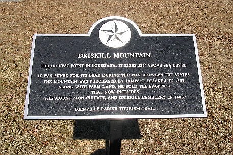
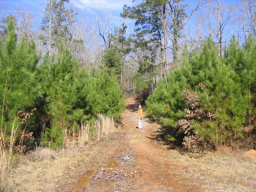
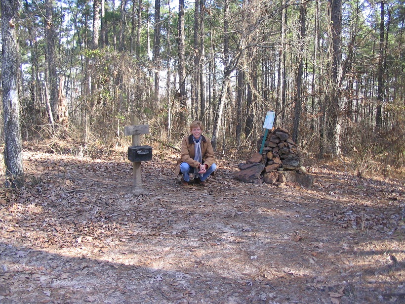
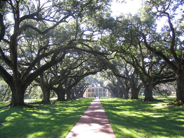
Driskill Mountain is the highest point in Louisiana, a mere hilltop that rises to 535 feet above sea level, located in the northern part of the state near Jonesboro. The area is forested in piney woods, but an old road allows for easy, brush-free passage to the top. I botched my first attempt in 1997. I came back in 1999 and hiked it successfully, then again in 2004 as part of a Christmas trip to New Orleans.
January 1997: I had flown into New Orleans a few days earlier for a few days of hiking the highest points of the southeastern states. I also had some friends living in Baton Rouge, so I saved Driskill Mountain for last as I was heading back toward the southern part of the state.
I started today in Arkadelphia, Arkansas, and popped over the state line into Louisiana, arriving to the correct area with no troubles. I parked near a small church just off the road, then walked the road into the trees a few hundred yards. I did not have my guidebook, and didn't think I'd need it for such a simple hike. In the trees, it all looked the same, and I could only see a few dozen yards ahead of me. I scampered up one hill, and figured this must be the highpoint. So I turned around and started the walk out.
I found a side-road with the chain strung across it, but did not know at the time I was to follow that to the real top. I walked back to my car with an uneasy feeling I hadn't hiked it properly. I drove out anyway, and had a good time with my pals down south, but when I got home and checked the guidebook, I knew I had missed it. How frustrating!
March 15, 1999: I returned in March 1999, on a driving journey from Arizona with the intention of rehiking the Oklahoma state highpoint, and trying again here in Louisiana. Oklahoma was a success, and I drove south into Lubbock, Texas, then east on Interstate-20 to Eastland, where I stayed the night.
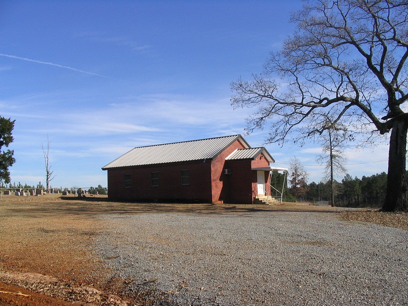
I awoke early the next day, and resumed driving eastward. Staying on Interstate-20, I passed through the Dallas-Fort Worth metroplex with no troubles, then a couple hours later into Shreveport, then another half hour to the town of Arcadia, near Driskill Mountain. I drove the little routes to the little country church that sits at the driveway to the highpoint. Wow, how had the scenery changed. The region had been logged extensively and an entire tract of trees near the church and along the highway were gone. I drove my truck in about a quarter-mile along the muddy access road, parked, and proceeded in.
This time, I had maps and trip reports and found the highpoint with no difficulty. As it turned out, it was one hill to the north of where I had gone the first time. After spending a few minutes surveying all before me, I hiked out back to my car, completing the round trip in about 30 minutes. All that driving for this. I made a long push west to Abilene, then home to Arizona the next day.
December 28, 2004: βð and I had been on the road now over a week, driving across Texas, then a few days in and around New Orleans for Christmas, during which it actually snowed for a day. So now we were up in the north part of the state.
We drove into Natchitoches, touring the riverfront with its thousands of lights strung up and across everywhere. The plan for today was to visit a few easy parish highpoints, a few historical markers (such as the Bonnie and Clyde one), and camp at Lake Claiborne.
For Driskill Mountain, we parked at the same church, with the piney forest regrowing after its levelling in 1999. The hike was fast and we were back to the car in about 40 minutes. Just then, a family drove up, with Illinois plates. They got out --- Pa, Ma and Kid --- with GPS unit in hand. I asked the dad if they were going to the highpoint and he did not really answer, just kind of verbalized something vague. Probably geocachers.
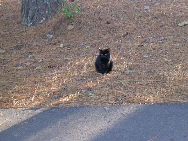
We spent the night camped at Lake Claiborne State Park, where a cute black kitty made friends with us that evening. The next day, we would start the long journey back to Arizona.
During our 2004 trip, we visited nine parish highpoints total. The funny thing is, we both still rank high on the "Louisiana Parish Highpoints List" at peakbagger. Very few people bother with the parish highpoints, and I can't blame them. The ones we visited were usually quick visits, and we spent far more time enjoying New Orleans, drives out to the remote bayous, touring plantations, eating good food, and having a fantastic time. The parish highpoints were only done as convenient, to break up the drives. Below are trip reports for a few of the more interesting ones.
Date: December 22, 2004
• Elevation: 57 feet
• Distance: negligible
• Time: 1 hour driving
• Gain: 2 feet if we're lucky
• Conditions: Rainy and cool
We started today in Baytown, Texas. The rain fell all day and often heavily. In Texas, we visited one scary county highpoint, then drove into De Ridder, Louisiana, for a late breakfast. The plan was to drive to Lafayette, where we had a hotel room reserved.
We visited two stupidly easy parish highpoints along the way, in Allen Parish (twenty-foot hike to a hill along side the road) and in Jefferson Davis Parish (short walks to small mounds near roads). The rain was brutal, falling so heavily it reduced visibility to near nothing at times, and created a loud continuous din on the truck's roof. It was mentally tiring.
Soon, we were in Acadia Parish, not far from Lafayette. The weather improved slightly, to clouds and sprinkles, but with no more heavy rain. The highpoint(s) of Acadia Parish lie in and around the communities of Pitreville and Church Point.
The highpoint could be located in any one of eleven separate areas enclosed within 55-foot contours. However, one large blob of land has three points marked with 57-foot spot elevations. Thus, the plan was to visit these three points, then visit the remaining areas as we drove the roads in and around the area.
We came into this largest area first, on eastbound US-190 toward the community of Swords, and followed state routes LA-752 and LA-751 south to where LA-751 junctions with LA-358. This is the northeast corner of the parish and location of one of the 57-foot spot elevations. We got out and looked around. We visited the second 57-foot spot elevation a few moments later, westbound along LA-358. About a mile later we came to the junction with LA-1103 at Pitreville. South along LA-1103 put us inside one of the bigger areas. Once again, we got out and looked around.
The third 57-foot spot elevation is found along Wagon Road south of a thicket of natural woods, which was higher by about a foot than the road, so in my opinion, this one area is the likeliest natural highpoint of the parish. We also toured Pamela and Gobert Roads and got back out onto LA-1103. All this took about a half-hour.
Next, we proceeded to Church Point and visited the small areas scattered about the town and the immediate area. They are all small and probably not contain the highpoint. We got slightly turned around on the roads and made unplanned detours, but finally found ourselves north of town along LA-35. A re-route of the highway confused us, since our map was apparently not up-to-date.
The last were a pair of areas along Plaquemines Road near the parish boundary. The rain stayed light for most of this journey, which took a total of about an hour to complete. From here, we drove into Opelousas and Lafayette and treated ourselves a fine Cajun dinner at Prejean's, a famous restaurant and music hangout along Interstate-49 north of Lafayette. I dug into some gumbo while the both of us ate alligator for the first time ever.
As far as parish highpoints go, we didn't bother with any for a few days, mainly as we explored in and around New Orleans. We spent a half-day driving south on less-traveled state routes. We drove to Houma for no particular reason. It was a place to go then turn around. We also drove to the Cypremont State Park.
There were two parish highpoints that we explored while down this way. One is a salt-dome hill called Weeks Island in Iberia Parish. It is apparently owned by the Morton Salt Company. I had emailed them for permission before we left but they declined to allow us on. We drove there anyway, but it's surrounded by substantial fencing, so we continued on our way.
We also looked at the Saint Mary Parish highpoint, on Cote Blanche Island. We were deep into the bayou, where it can be hard to tell what's land and what is swamp. Cote Blanche Island is apparently another salt dome, given its elevation of about 93 feet above sea level. We drove to where a private ferry would take cars across about 500 feet of bayou. I called the number on the sign and a guy answered. When I told him what we wanted to do, he apologized and said he couldn't allow us to come over. I expected that response, so we were not surprised. So we left.
Yes, I did consider the Orleans Parish highpoint, in and around New Orleans. It was not convenient to get to and even I felt no particular urge to waste time finding it.
We enjoyed our drive in the bayou, fascinated by the scenery, homes on stilts, water up to the road, and the whole vibe. You don't see too much of this in Arizona.
Date: December 27, 2004
• Elevation: 25 feet
• Distance: negligible
• Time: a few minootsa
• Gain: umm...
• Conditions: Nice
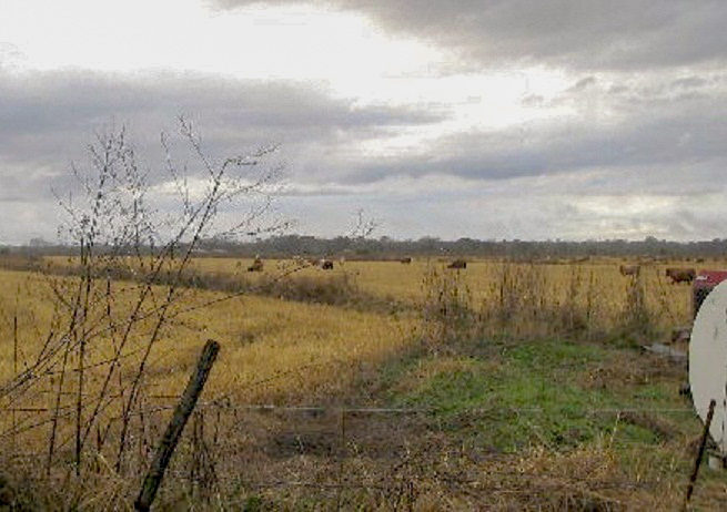
St. John the Baptist Parish is located about 30 miles west of New Orleans in bayou country of southern Louisiana. Most parishes along the Gulf of Mexico rarely exceed 10 or 15 feet of elevation, and any natural high ground has been built upon and altered in some manner. Often, it's the levees that are the highest points, but since they are man-made, they "don't count". That leaves few options for locating the actual natural highpoint.
There's also the issue of accuracy of the maps, the altering of landforms due to natural events such as floods and hurricanes, and cases where a single highpoint contour may stretch many dozens of square miles across inaccessible terrain. Many of the bayou and gulf parish highpoints have never been officially visited or logged due to these reaons, and I suspect never will. It's no wonder this conundrum propels the average Louisiana highpointer to soak his sorrows in good gumbo, music, parades, beads and beer.
We were in Louisiana for the Christmas holidays, and naturally, trying to visit some of the parish highpoints, mostly with no luck. However, the highpoint of St. John the Baptist Parish is an exception. The highpoint is a sand bar that rises to 25 feet elevation and apparently is not altered or covered over by a levee. Not only that, there's a road close to it. Given all the other fascinating distractions this part of the state has to offer, we surrounded the 10-minute visit to this highpoint with about three or four days of other fun activities.
We actually arrived in the area three days earlier, coming to the towns of Gramercy and Lutcher on the 24th (Christmas Eve) to view an amazing spectacle: dozens of massive log pyres lined along the levees, set alight as the sun set, to herald Christmas. Apparently this is a tradition dating back over a hundred years. We arrived about 2 in the afternoon and sat in the truck until 7, when the pyres were lit. Thousands of people were in attendance, walking along the levees and taking in the sights, as were we. The weather was very cold, in the mid 20s, and the fires felt great. Some pyres were 20-30 feet tall, and the builders take pride in building them to burn with maximum efficiency and ferocity. You obviously don't just pile up a bunch of logs; there's an art to it. Some families do this as tradition and each has their own style.
Aside from the pyres, the levees and nearby roads were choked with vendors and people out for the experience. Local families would set up stands selling home-cooked meals. I bought a chicken dinner meal in the best of traditional soul-food cooking from one of the local families, and the food was wonderful. Seriously, I could have moved in with them just for the food alone. Maybe do yard work to earn my keep.
So we watched the pyres from our truck as well as walking among them, and we hung out until about 10 p.m. At some point the cold started to get to us and we wanted to get to our hotel, which we'd booked in the small community of Laplace about 30 miles west of New Orleans along Interstate-10. You're probably wondering if it's named for French mathematician Pierre-Simon Laplace, but I suspect no. Nevertheless, I did take time to think fondly about his useful transforms that solve certain boundary-value differential equations in one big step rather than needing to solve each constant of integration individually. Anyway, the plan was to visit the stupid parish highpoint on Christmas Day, on our way to New Orleans.
Well, Christmas Day started with freezing rain, sleet and snow. Sections of Interstate-10 had been shut and some main bridges were closed due to ice conditions. This forced our hand: we got our fannies into New Orleans before they shut the whole interstate, which they actually did for half the day. We skidded and slid into town and took refuge at a casino, where we each won about $30, paying for a Christmas meal and a movie later on. We walked around the area, but the conditions were biting and most people stayed in. This was the first snow in New Orleans in 15 years and the first time it ever snowed on Christmas Day.
The next day was stupendous: clear, with temperatures in the 50s. It's like the snow never happened. We spent the whole day walking the roads around the French Quarter, going into the shops, checking out the statues, and playing tourist. This was our "official" New Orleans tourist day. We stayed in a hotel near Metairie.
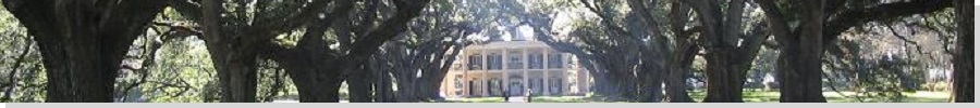
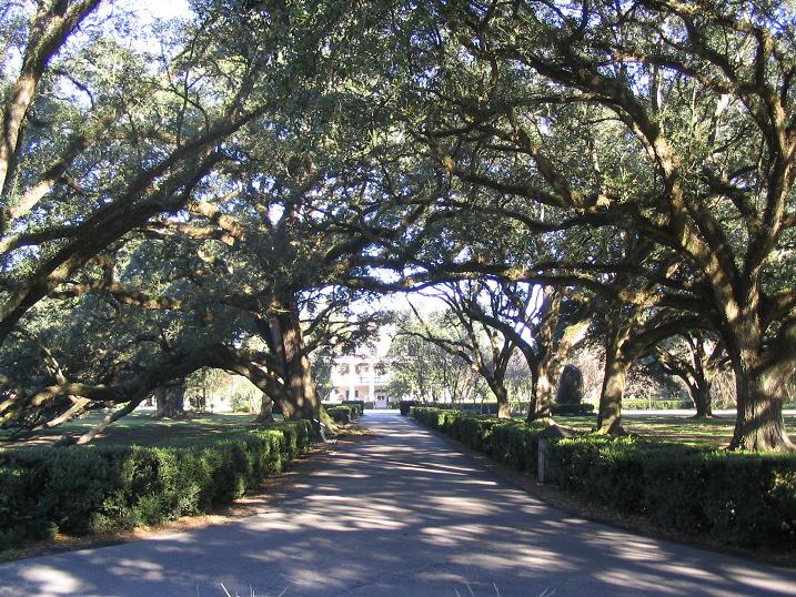
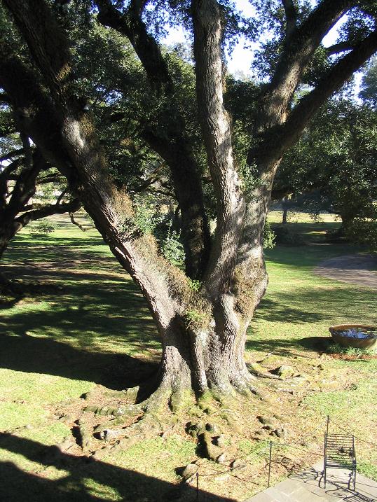
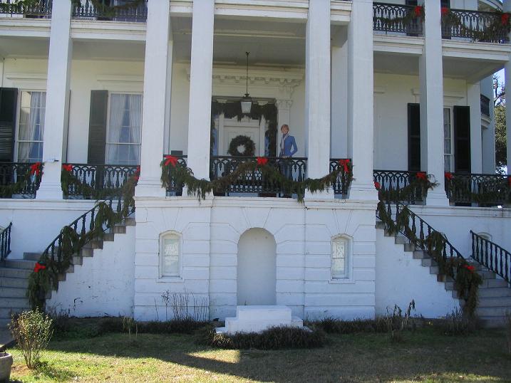
The next day was going to be our "plantation mansions tour" day. These homes date from the plantation era of the 1700s and 1800s, some going back to when the French had control of the area. The mansions are interesting, but the humongous oaks that lined the walkways were far more impressive to me: big giant trees, utterly magnificent. We toured a couple of the plantations and this took up about most of the morning. Once done with the plantations, we drove a couple hours north and ended the day in Natchitoches, where we had a dinner and a walking tour of the downtown, where their big thing is to string up lights everywhere, and it was lovely.
Oh yes, the highpoint. That's why you're reading this. We did that this morning before the plantations. We exited Interstate-10 at Gramercy and went over the giant bridge that spans the Mississippi River onto state route LA-18 to a point east of the community of Wallace. From here we left the road and took a dirt road up over a levee and down into the sand-bar area that holds the parish highpoint. The levee itself is about 34 feet elevation (say the maps), while the "natural" highpoint is about 25 feet. The area was open dirt, some trees, some work trucks, a mix. We explored the high ground and figured we visited the highspot at some point, but frankly, we didn't spend a whole lot of time here.
Date: December 28, 2004
• Elevation: 460 feet
• Distance: negligible
• Time: mere moments
• Gain: 8 inches
• Conditions: Lovely
First on today's agenda was the highpoint of Winn Parish, about 25 miles to the northeast of Natchitoches. We were interested in it for two reasons: at 460 feet, it is one of the higher bumps in Louisiana, and it was real simple, just yards from a road. We were in the forested parts of the state, and the scenery was quite pleasant.
We got onto US-84 eastbound toward Winnfield, and then turned north onto Range Road, across from the Gum Springs Campground within the Kisatchie National Forest. We went north 1.2 miles then turned left and stopped at a gate spanning the road. The highpoint was just a few feet of walking past the gate to a rise in the road. We explored the nearby woods for higher ground, but the cleared area looked highest. The whole visit took five minutes.
We then visited two more parish highpoints, but neither were that pretty. We visited the highpoint of Lincoln Parish because it was close to Driskill Mountain, but it was in a muddy cleared area of the trees and rather homely. Then we visited the highpoint of Webster Parish. It was a viney short hike, but with lots of dumped furniture and crap along the roads.
Date: December 28, 2004
• Elevation: 505 feet
• Distance: drive-up
• Time: not much
• Gain: none
• Conditions: Pleasant
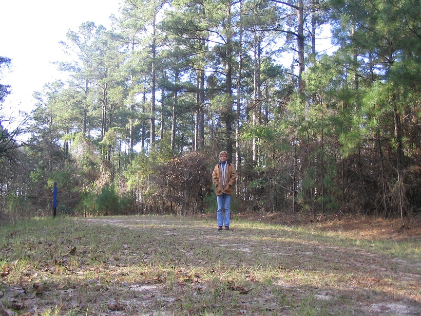
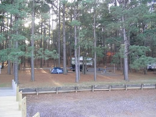
We headed east toward the town of Athens, from which we would go northeast to Lake Claiborne State Park, a popular campsite and fishing spot in northern Louisiana where we planned to camp. Claiborne Parish's highpoint is along the way, so we visited it.
From the town of Old Athens, we went north past a church and cemetary for a mile, then east on Fire Tower Road for 0.3 mile, then northeast on the unnamed road to the top. The top is a cleared area ringed by trees. We stayed long enough to get a photo of me, and that was all. This otherwise unremarkable spot is the second-highest parish highpoint in the state, after Driskill Mountain.
From here we continued on to Lake Claiborne and found a spot to set up for the night. The lake is big and popular for fishing. However, on our visit the water level was down. Walking out to the end of the pier, I was standing over mud.
That night we had ourselves a good fire and sat around it, checking out the stars. A cute and friendly black kitty hung around us, and we pet it and gave it some treats. It may have belonged to a nearby camper or even the camp-host. Or it may have been a stray. That night it pawed at our tent door to get in. I hope it has a good home.
|


|
(c) 2004, 2021 Scott Surgent. For entertainment purposes only. This report is not meant to replace maps, compass, gps and other common sense hiking/navigation items. Neither I nor the webhost can be held responsible for unfortunate situations that may arise based on these trip reports. Conditions (physical and legal) change over time! Some of these hikes are major mountaineering or backpacking endeavors that require skill, proper gear, proper fitness and general experience. |