
The Mountains of Colorado
• www.surgent.net
|
| West Spanish Peak |
• Highpoint: Las Animas County • Highpoint: Wahatoya Mountains • San Isabel National Forest |
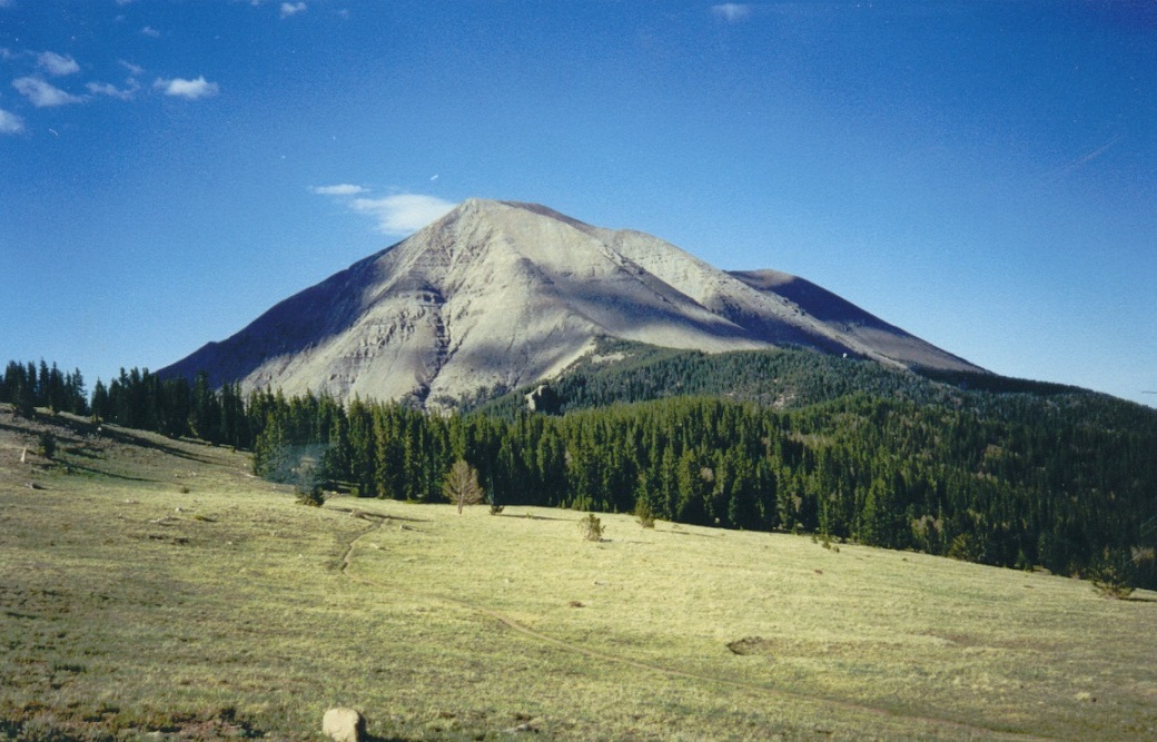 West Spanish Peak in all its glory
|
Date: May 31, 2002
• Elevation: 13,626 feet
• Prominence: 3,666 feet
• Distance: 6 miles
• Time: 4 hours
• Gain: 2,600 feet
• Conditions: Marvelous
Colorado
•
PB
West Spanish Peak is the highest of the two Spanish Peaks, which rise from the plains southwest of Walsenburg, in southern Colorado. The name of the range, Wahatoya, translates as "breasts of the Earth". From a distance, one can see why this is an appropriate name.
I was in Eastern Colorado, busying myself with a series of relatively easy mesa hikes, then heading west toward the Spanish Peaks. I first drove to Walsenburg to resupply, then followed US-160 and CO-12 to Cucharas Pass. Along the way, I marvelled at the massive dikes that radiate from the peaks. These dikes are walls of lava rock that rise up to a couple hundred feet tall, and about 40 to 100 feet wide. Many have holes and other natural arches in them.
From Cucharas Pass, I drove a few more miles along Forest Road to Cordova Pass, elevation 11,240 feet, arriving at 3 in the afternoon. One other vehicle was there, but they left within an hour, so I had the whole place to myself for the rest of the day and the night.
I did not do much except sit, read and look at the scenery, including the rocky slopes of West Spanish Peak, visible about 3 miles away. I hiked out to Levy Lookout, a 1.5-mile round-trip hike, mainly to get some conditioning in. I had not been at this elevation in awhile and needed to acclimate fast before tomorrow's big hike.
I slept in the bed of my truck, the night quite cold given I was over two miles in elevation. I did not sleep well, waking often due to irregular breathing as a result of the thinner air and lack of oxygen. I woke early and was hiking at 5:30 a.m., the sun already up but still low to the east.
The route was short but aggressive: I had about a two-mile hike through forest in which the grades were moderate, then a very steep grind up the talus slopes to the summit. From where I started, the rock slopes looked impossibly steep. However, I knew there was a route knocked in. I'd just have to find it.
The forest hike went fast. The trail ends at a large cairn, directly below the talus slope. From here on up, there would be no trees and almost no vegetation at all. I needed to gain 1,600 feet in a mile. The trail by now is essentially a weak path through the rocks, or an occasional cairn, or nothing. Fortunately, the slope lied back so that climbing it was not technical, just steep.
I took the rocks in hundred-foot segments. I'd find some semblance of a route, follow it, lose it, then look up and spy a rock formation, and hike to it. Then repeat. I never got too far off route, as there was always some way up. At worst, I had to use the hands to clamber up some big rock steps. Then I'd find a cairn and be back on route. I kept to this for about an hour, and slowly, the incline lessened and I was now on the home stretch.
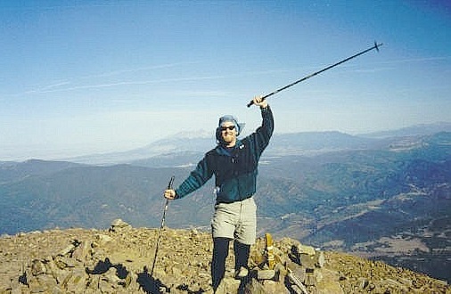
The summit was in view, about 300 feet up and another quarter-mile away, and I reached the summit at 8:10 a.m. At 13,626 feet, this was the highest I'd been since my hike up Mount Rainier in 1997. But I felt good, last night's breathing episodes long gone. There are three summits, the farthest being highest. I signed the register, snapped some shots, then waited as another guy was slowly coming up. When he arrived, we chatted and he snapped a photo of me. He then sat and waited for his buddy while I started down.
Going down wasn't too bad. Actually, I could see the faint trails better, but the loose rock at those lower cliffs slowed me. My trekking poles were vital, but once or twice I used five points of contact to get down the tricky sections. I was soon back to the trail in the forest, and walked out, arriving back to my truck at 10:30 a.m. I didn't see anyone else the whole way down.
This was a brilliant, invigorating climb that challenged me. The views from the summit were magnificent and I was blessed with great weather. It was actually much easier than it first appeared. It was still early, so I drove to Greenhorn Mountain near Pueblo, which I hiked a few hours later.
|
|