The Mountains of California
www.surgent.net |
| Junipero Serra Peak |
• Highpoint: Monterey County • Highpoint: Santa Lucia Mountains • Los Padres National Forest |
 The summit from below
|
Date: May 11, 2001
• Elevation: 5,862 feet
• Prominence: 4,447 feet
• Distance: 12 miles
• Time: 7 hours
• Gain: 3,900 feet
• Conditions: Sunny and hot
California
•
Main
•
PB
The highest peak in Monterey County is Junipero Serra Peak in the coastal ranges west of the Hunter-Liggett Military base. From my home in Arizona, it's a long drive, nearly 700 miles one way. I broke the drive up into segments: one day to Monrovia, where I stayed at my pal Treetops' place, and another day to Paso Robles, where I stayed in a cheap hotel.
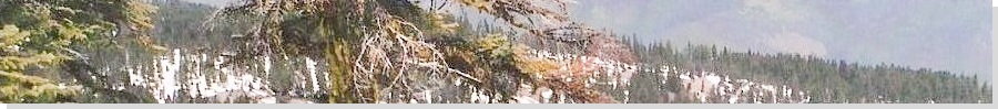
I awoke at 4 a.m. the next morning and started toward the peak. I drove to the town of Bradley, then took Jolon Road to the Hunter-Liggett Military Reservation, then smaller roads west and north to the Los Padres Forest Boundary. Another few miles of twisty driving brought me to the trailhead at "The Indians", which are natural stone formations in the area. I geared up and started hiking at 6:15 a.m., the only person here as far as I could tell. The land here is hilly and mountainous, with tight canyons, heavy forest and dense undergrowth. At this early hour, and not more than ten miles from the ocean, it was warm. Today would be a hot day.
The initial portion of the hike was along the base of the main range, level with some ups and downs as I crossed about six creeks and a dozen drainages. Soon, the trail bent left (north) and I spooked a skunk, who was too far away to spray me. He just walked away as I banged my walking stick against a rock to make noise. The trail began to gain steadily at this point, crossing more streams and working steeply up a ridge. I came to a sign in a meadow which mentioned the Santa Lucia Lookout at the summit was four miles away. I took a snack break here.
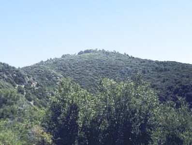
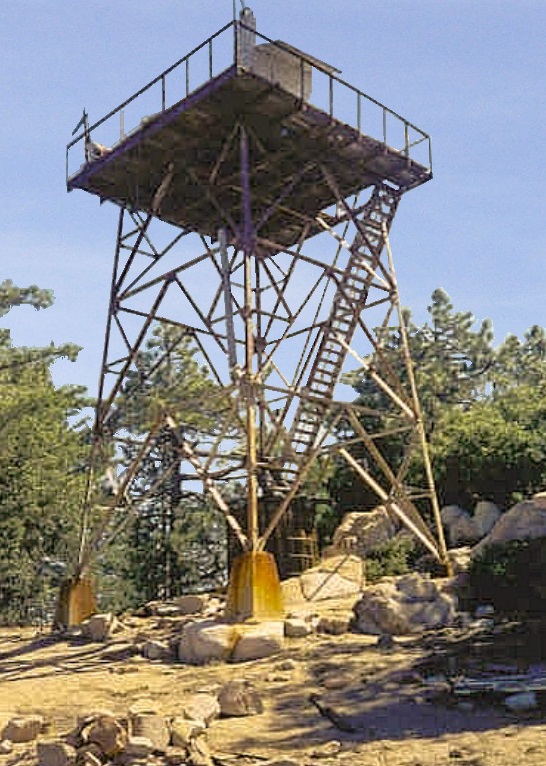
From this sign, I continued up the ridge, leaving the forest and entering into dense, chest-high chaparral. The sun was high enough over the mountains to give me direct sunlight, and I could feel the temperatures rise. I arrived at a saddle at elevation 4,200 feet, about 2,000 feet above where I started. Another smaller sign at the junction pointed to Serra Peak, still two miles away. I could see the Santa Lucia Lookout tower, barely protruding above the summit, still 1,700 feet above me. I still had a lot of work to do. It was now 8:00 a.m.
I continued northeast up a series of long switchbacks through the chaparral and occasional leafy trees toward another saddle at elevation 5,440 feet, arriving at 9 a.m. From here, the summit was obscured behind a smaller foreground peak, but the trail leveled as it contoured behind this smaller peak and up behind the main summit. I found a big fallen tree to sit on and relax before I made the final push to the top, where I arrived at 10 a.m. It had taken me 3 hours and 45 minutes, with almost 4,000 feet of elevation gain in six miles.
The summit is wide and long. The Santa Lucia Lookout tower was in bad shape, and I didn't dare scale it. The area wasn't too attractive, either. I mounted a couple of rock piles along the ridge, one of which should be the highest point. It was getting warm and the flies were buzzing me, so I didn't stay long. At 10:15, I started down. Back at the saddle at 5,440 feet, I saw two hikers coming up, the only people I saw the whole day. I was back to the first sign by 11:30.
By now, it was hot. The shade offered little relief. I still had two miles to my truck. The path was level, so it wasn't difficult, but the heat, in the 90s, was really tough. I took it slow, rested regularly, and arrived back to my truck at 1 p.m. I carried LOTS of water, gatorade and a protein drink, and I went through it all. I felt good, all things considered. Despite the heat and dense brush, I enjoyed this remote hike, and would come back in the future.
From here, I returned to Paso Robles, then took a different route to SoCal, taking CA-46 over the Temblor Range through Cholame (Where James Dean punched his ticket) to the flatness of the San Joaquin Valley and Interstate-5, then across Bakersfield, up through Tehachapi to Mojave, then down through Palmdale and the "back-way" to Interstate-15 to Cucamonga. The mileage was about the same (250 miles) but I avoided Los Angeles entirely, and probably two hours of sitting in Friday night traffic.
My niece turned one this weekend, so we partied. It was fun to watch her make mush of her cake. A day later, I made the hot and boring drive home to get my head right for summer teaching chores. But I felt good. I got a peak done, and also a chance to play with little Em.
|
|