The Mountains of California
• www.surgent.net
|
| Caliente Mountain |
• Highpoint: San Luis Obispo County • Highpoint: Carrizo Plain National Monument • Central California Coastal Ranges |
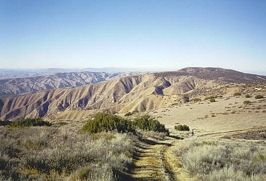 The Caliente Range from on high
|
Date: December 16, 2000
• Elevation: 5,106 feet
• Prominence: 2,206 feet
• Distance: 17 miles
• Time: 6 hours
• Gain: 1,165 feet, plus 1,000 feet when all ups and downs are added
• Conditions: Crisp and dry
• Teammates: Adam Helman
California
•
Main
•
PB
When people think of San Luis Obispo County, they probably think of rolling grassy hills dotted with oaks, like from a Steinbeck novel. Or maybe they think of the ocean and the picturesque towns on the shoreline such as Morro Bay and Pismo Beach. Or perhaps they think of the inland cities of Atascadero and San Luis Obispo, with their pleasant year-round weather and rich history including a few of California's famous missions. Few likely think of stark desert, but this is what the eastern third of the county consists of, a little slice of central Nevada right here by the ocean.
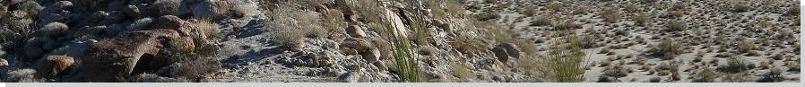
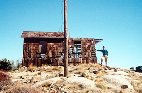
The county's highest point is Caliente Mountain, which rises above a broad desert plain known as the Carrizo Plain. The plain is rain-shadow desert, with a few dry lakes sitting in the lowest depressions. Few people live out here and almost no one ventures out this way unless they have business to attend to. Caliente Mountain is a long ridge that tops out at 5,106 feet, and during World War II, a lookout was built at the summit to watch for possible air attacks from the Pacific Ocean. Up this high, views are tremendous.
My first time in the area was in 1990. I accompanied a college friend to the Los Padres National Forest, hunting for feral pig. We came up the usual way, via US-101 and the scenic grass-and-oak valleys. The forest itself was a mix of trees and open areas. We hunted for a couple days with no luck, but the experience was a lot of fun.
Exiting, we got onto state route CA-58, heading east. The map showed we would get to Bakersfield this way. I was truly surprised just how big and how vacant the desert was out here ... and that there was one here to begin with. Like most people, it would not have occurred to me there is a bona-fide desert here.
We stopped for snacks at a small general store (note: I did not say mini-mart) in California Valley, the closest thing to a town out here. It was just a few buildings, a weak nexus for the scattered homesteads out this way. I recall the proprietor was a big guy with a scraggly beard. We continued east through the Temblor Mountains and the San Andres Rift Zone, dropping into the Central Valley near McKittrick, thence to Bakersfield and on home.
I would not return for ten years. Adam Helman and I agreed to meet and hike this peak, along with Santa Barbara County's highpoint, Big Pine Mountain, also here in the general region. We planned to hike both peaks over two days. Caliente Mountain's "easiest" route requires 17 miles round trip, which is just a warm-up for the 32 miles needed to hike Big Pine Mountain. If successful, we'd be putting in nearly 50 miles over the weekend. We came prepared with bicycles.
I drove from Phoenix and 500 miles later, had located myself to the little town of Maricopa, about 45 miles southwest of Bakersfield. The town is tiny, just a few hundred people. But it does have a decent hotel, the "Motel 9". This is where I stayed the night. Early the next morning, Adam drove in, and we met one another for the first time. He transferred his gear into my truck, parked his car here at the hotel, and we were off.
From Maricopa, I drove us west along route CA-166 to Soda Lake Road, then northwest on Soda Lake Road through the foothills, emerging onto the Carrizo Plain. At first, the Carrizo Plain was socked in with heavy fog. The road itself was unpaved in segments, but there was no one else up here except for us. I stayed on Soda Lake Road for 29 miles to the turn off for Caliente Mountain. The fog dissipated as the sun rose.
From Soda Lake Road, I followed a steeper service road to the range crest, the last mile rather steep on exposed shelf roads that in wet weather would be treacherous to drive. Once at the range crest, I parked near a substantial gate. We were eight miles from the summit. The road goes most of the way to the top, but the gate kept us from driving farther. We started our trek at 9 a.m.
The first two miles of road was pretty good, clearly maintained on a regular basis. We came to the top of one ridgepoint where some workers were there, erecting a new tower. They had driven up from a different location, and were surprised to see us. After that, the road's condition grew worse. In another mile and a half, we came to a wrecked trailer in a clearing, apparently an old ranch-hand residence from years ago. We were about halfway to the top.
The farther we walked, the worse the road became. It essentially petered out into a footpath after two more miles, passing by a helicopter landing pad where we stashed our bicycles. The road then dropped and for the remaining couple of miles, worked its way up and down intervening ridge points until finally emerging to the summit. We arrived here at 12:15 p.m. in clear conditions.
The building up top is (was) a fascinating historical relic from the World War II days. It may seem silly to worry about an air-invasion from the Pacific, but just to the east were the big oil fields surrounding Bakersfield. Those would have been an attractive target for an invading enemy. When we arrived. the building was barely standing, basically staying erect out of habit. It would creak in the wind and was completely unsafe. Nevertheless, we explored around it and took a one-hour break on the summit, happy to be here and admiring the views in all directions.
We started walking out at 1 p.m., picking up our bikes and riding the downhill segments whenever possible. We exited in less than two hours, riding out most of the last four miles on the good service road. We were back to my truck at 3 p.m., which amounted to a six-hour day --- the bicycles certainly helped cut off a lot of the time. After reloading the truck, I inched us down to Soda Lake Road and back to state route CA-166. Instead of returning to Maricopa, we drove west and south on route CA-33 to situate ourselves near tomorrow's big hike, Big Pine Mountain. Being so close to the Winter Solstice, the sun set early this time of year. We were already into dusk as we rolled into camp at the Willow Campground.
The old shack finally collapsed, probably in 2012 or early 2013. I found an interesting report with photographs of the old summit structure. Also, the trailer at the four-mile mark has also decayed into a heap of metal too, judging by his photographs. I wish I had taken more images while there but this was back in 2000 when digital was still very expensive and I wanted to "conserve" my film. Those were the days.
|
|